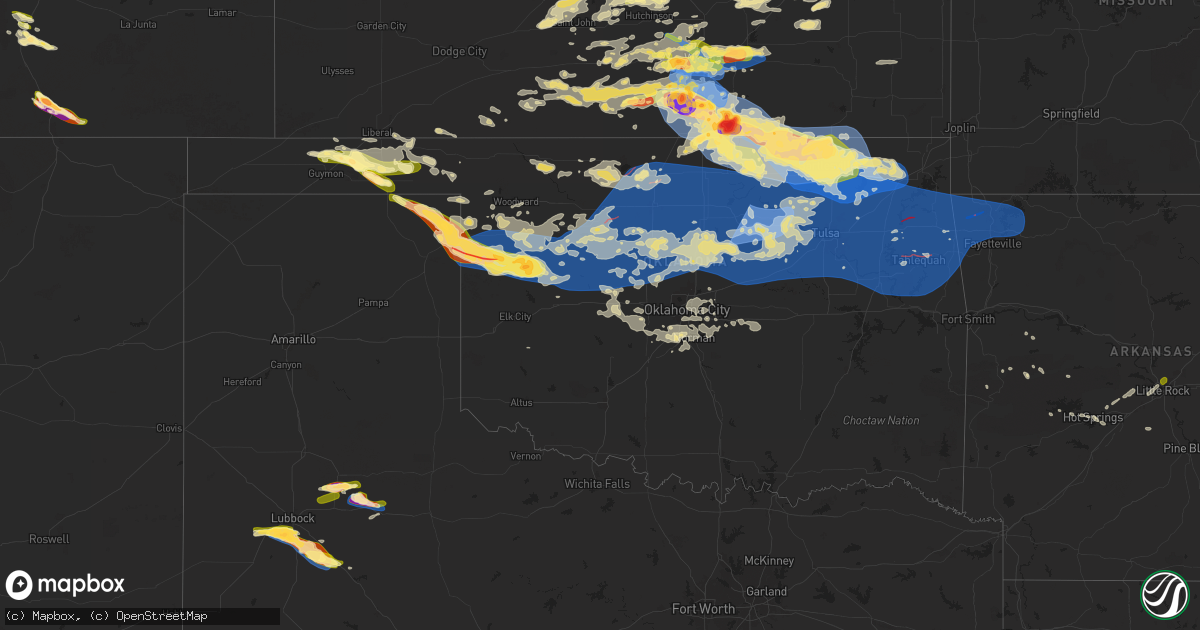
Hail Map in Oklahoma on June 17, 2025
Get this storm
June 17 map
$229
one time, instant access
Download today. No call, no setup
Keep the $229
Bought the map and want the full workflow? Apply the entire $229 to a subscription within 7 days. None of it is wasted.
Every map, not just this one
This buys you this map. Subscription and you get every map we run, in the markets you choose from a few cities to whole states to nationwide. Plus real-time alerts the moment a storm fires.
Contact data
Name, contact info, occupancy, even credit band for addresses in the footprint. You go from where it hit to who to call.
Become the source they trust
Unlimited branding weather history reports on demand. You already have the documented answer ready for the property owner, and you are the one who showed up with it.
Property data and RoofTrace estimates
Pull up any address you have got, its value and the exact code rules for that jurisdiction, straight from One Click Code. Then RoofTrace estimates the squares, pitch, and roof value, priced the way you price.
Storm reports in Oklahoma
Oklahoma
| Date | Description |
|---|---|
| 06/17/20256:32 PM CDT | Hail up to ping pong ball size fell. |
| 06/17/20255:37 PM CDT | Ping pong ball size hail fell. Report via social media. |
| 06/17/20251:25 AM CDT | A local report indicates 62 MPH wind near 5 WNW Westville |
| 06/17/20251:25 AM CDT | Tree down on hwy 10 and cnty road 652 blocking one lane. |
| 06/17/20251:14 AM CDT | Social media report indicating damage to several green houses caused by thunderstorm winds. |
| 06/17/20251:00 AM CDT | Tornado debris signature detected. |
| 06/17/202512:55 AM CDT | Tree on house at 96th and newton place. |
| 06/17/202512:48 AM CDT | Tornado debris signature detected. |
| 06/17/202512:47 AM CDT | A local report indicates 60 MPH wind near 4 WSW Oologah |
| 06/17/202512:45 AM CDT | A local report indicates 72 MPH wind near 4 NW Talala |
| 06/17/202512:40 AM CDT | A local report indicates 64 MPH wind near 2 ENE Copan |
| 06/17/202512:37 AM CDT | Ef1 with damaged homes... Destroyed outbuildings... And damage numerous trees. |
| 06/17/202512:34 AM CDT | A local report indicates 60 MPH wind near 2 ENE Copan |
| 06/17/202512:31 AM CDT | Transformers being blown. Estimated 70mph. |
| 06/17/202512:10 AM CDT | A local report indicates 69 MPH wind near 2 S Wynona |
| 06/17/202512:08 AM CDT | Large tree branch broken off main trunk and fell on vehicle. Additional tree damage in neighborhood. |
| 06/17/202512:07 AM CDT | Thunderstorm wind gust measured at 62 mph. Multiple tree branches broken and blown down at apartment complex. |
| 06/17/202512:06 AM CDT | Wooden pergola blown off back porch. Damage occurred near intersection of south cypress place and west jackson street. |
| 06/17/202512:05 AM CDT | 6 inch limbs down 51st and yale. |
| 06/17/202512:00 AM CDT | A local report indicates 64 MPH wind near 8 ESE Foraker |
| 06/16/202511:58 PM CDT | Damage to promenade mall. |
| 06/16/202511:55 PM CDT | A local report indicates 62 MPH wind near 2 S Wynona |
| 06/16/202511:50 PM CDT | Multiple trees and tree limbs broken or damaged vicinity of eagle view rv park... East of the keystone dam and just south of highway 412. Time estimated by radar. |
| 06/16/202511:45 PM CDT | Numerous 10-12 inch thick limbs down. |
| 06/16/202510:05 PM CDT | A local report indicates 65 MPH wind near 3 SE Delaware |
| 06/16/20259:55 PM CDT | A local report indicates 71 MPH wind near 1 NNW Watonga |
| 06/16/20259:45 PM CDT | A local report indicates 65 MPH wind near Watonga 7W |
| 06/16/20259:40 PM CDT | Personal weather station. |
| 06/16/20259:27 PM CDT | A local report indicates 1.75 inch wind near 1 W Copan |
| 06/16/20259:20 PM CDT | A local report indicates 60 MPH wind near 10 S Bartlesville |
| 06/16/20259:20 PM CDT | A local report indicates 65 MPH wind near 4 N Putnam |
| 06/16/20259:14 PM CDT | A local report indicates 1.25 inch wind near 5 ENE Optima |
| 06/16/20259:05 PM CDT | Report from mping: ping pong ball |
| 06/16/20258:55 PM CDT | A local report indicates 63 MPH wind near 5 NW Camargo |
| 06/16/20258:53 PM CDT | Roof damage and power out. |
| 06/16/20258:47 PM CDT | Corrects previous tstm wnd gst report from foraker. |
| 06/16/20258:40 PM CDT | Report from mping: quarter |
| 06/16/20258:37 PM CDT | Half dollar sized hail reported by a trained spotter. |
| 06/16/20258:37 PM CDT | A local report indicates 1.25 inch wind near 8 SW Arnett |
| 06/16/20258:34 PM CDT | A local report indicates 63 MPH wind near 8 ESE Foraker |
| 06/16/20258:10 PM CDT | A local report indicates 65 MPH wind near 8 WSW Arnett |
| 06/16/20257:47 PM CDT | Quarter to ping pong ball sized hail noted on dot cameras. |
All States Impacted by Hail Map on June 17, 2025
Cities Impacted by Hail Map on June 17, 2025
- Idalia, CO
- Cope, CO
- Akron, CO
- Yuma, CO
- Fort Collins, CO
- Nunn, CO
- Wellington, CO
- Pawnee, OK
- Cushing, OK
- Ripley, OK
- Stillwater, OK
- Glencoe, OK
- Yale, OK
- Maramec, OK
- Elizabeth, CO
- Parker, CO
- Otis, CO
- Byers, CO
- Wray, CO
- Kiowa, CO
- Woodrow, CO
- Jennings, OK
- Cleveland, OK
- Drumright, OK
- Hominy, OK
- Osage, OK
- Terlton, OK
- Fort Morgan, CO
- Haigler, NE
- Mannford, OK
- Marion, LA
- Murdock, KS
- Cheney, KS
- Deer Trail, CO
- Kingman, KS
- Lindon, CO
- Anton, CO
- Bristow, OK
- Garden Plain, KS
- Viola, KS
- Goddard, KS
- Conway Springs, KS
- Clearwater, KS
- Milton, KS
- Wellington, KS
- Peck, KS
- Belle Plaine, KS
- Haysville, KS
- Wichita, KS
- Derby, KS
- Udall, KS
- Mulvane, KS
- Oxford, KS
- Winfield, KS
- Bastrop, LA
- Pretty Prairie, KS
- Broken Arrow, OK
- Haskell, OK
- Haven, KS
- Mount Hope, KS
- Andale, KS
- Colwich, KS
- Saint Francis, KS
- Mcpherson, KS
- Agate, CO
- Windom, KS
- Galva, KS
- Cedar Vale, KS
- Limon, CO
- Laramie, WY
- Walden, CO
- Genoa, CO
- Lyons, KS
- Chase, KS
- Colorado Springs, CO
- Delaware, OK
- Little River, KS
- Nowata, OK
- Peabody, KS
- Marion, KS
- Hamilton, KS
- Cassoday, KS
- Eureka, KS
- Bazine, KS
- Sedalia, CO
- La Crosse, KS
- Burns, KS
- Florence, KS
- Alexander, KS
- Drake, CO
- Glen Haven, CO
- Virgil, KS
- El Dorado, KS
- Raymond, KS
- Jayess, MS
- Hugo, CO
- Bosler, WY
- Ellinwood, KS
- Hudson, KS
- Bison, KS
- Nekoma, KS
- Rush Center, KS
- Estes Park, CO
- Paris, AR
- Magazine, AR
- Woodland Park, CO
- Divide, CO
- Larned, KS
- St John, KS
- Monument, CO
- Larkspur, CO
- Cedar Point, KS
- Franktown, CO
- Mount Ida, AR
- Hillsboro, KS
- Arriba, CO
- Livermore, CO
- Belpre, KS
- Fountain, CO
- Mena, AR
- Royal, AR
- Lisman, AL
- Laurel, MS
- Cottonwood Falls, KS
- Bellvue, CO
- York, AL
- Ward, AL
- Garfield, KS
- Elbert, CO
- Loveland, CO
- West Point, NE
- Lyons, CO
- Hot Springs National Park, AR
- Hill City, SD
- Macksville, KS
- Matfield Green, KS
- Green Mountain Falls, CO
- Waldron, AR
- Canton, KS
- Alden, KS
- Elk Point, SD
- Manitou Springs, CO
- Peyton, CO
- Carr, CO
- Usaf Academy, CO
- Harvey, AR
- Chatsworth, IA
- Hawarden, IA
- Akron, IA
- Sterling, KS
- Berthoud, CO
- Long Pine, NE
- Geddes, SD
- Newport, NE
- Stuart, NE
- Inman, KS
- Lehigh, KS
- Olpe, KS
- Longmont, CO
- Nickerson, KS
- Hutchinson, KS
- Lead, SD
- Pavillion, WY
- Danville, AR
- Deadwood, SD
- Boulder, CO
- Salemburg, NC
- Roseboro, NC
- Autryville, NC
- Rapid City, SD
- Yoder, CO
- Cascade, CO
- Niwot, CO
- Louisville, CO
- Lafayette, CO
- Broomfield, CO
- Erie, CO
- Timnath, CO
- Windsor, CO
- Plainview, AR
- Sylvia, KS
- Smithville, GA
- Elmdale, KS
- Bluffton, AR
- Chanute, KS
- Vilas, NC
- Beulah, CO
- Goessel, KS
- Erie, KS
- Golden, CO
- Sheridan, AR
- Strong City, KS
- Milliken, CO
- Greeley, CO
- Hartford, KS
- Madison, KS
- Pueblo, CO
- Burns, WY
- Pine Bluffs, WY
- Hermosa, SD
- Keystone, SD
- Plevna, KS
- Fort Lupton, CO
- Platteville, CO
- Custer, SD
- Denver, CO
- Alton, IA
- Orange City, IA
- Platte, SD
- Arvada, CO
- Wheat Ridge, CO
- Zionville, NC
- Lincolnville, KS
- Brighton, CO
- Dacono, CO
- Abbyville, KS
- La Salle, CO
- Atkinson, NE
- Karval, CO
- Gridley, KS
- Leonard, MO
- Shelbyville, MO
- Henderson, CO
- Roscoe, MT
- Commerce City, CO
- Bushnell, NE
- Buhler, KS
- Bethel, MO
- Edgemont, SD
- Partridge, KS
- Grover, CO
- Fairburn, SD
- Westminster, CO
- Thornton, CO
- Kaycee, WY
- Boone, CO
- Sterling, CO
- Lance Creek, WY
- Anabel, MO
- Aurora, CO
- Colorado City, CO
- Hudson, CO
- Fishtail, MT
- Beattyville, KY
- Jackson, KY
- Haswell, CO
- Cheyenne, WY
- Hillsdale, WY
- Rye, CO
- Merino, CO
- Douglas, WY
- Le Mars, IA
- Stoneham, CO
- Buffalo Gap, SD
- Lusk, WY
- Gillette, WY
- Attica, KS
- Hot Springs, SD
- Slaughter, LA
- Lake, MS
- Remsen, IA
- Harper, KS
- Winner, SD
- Colome, SD
- Kingsley, IA
- Clinton, LA
- Glenrock, WY
- Cunningham, KS
- Walsenburg, CO
- Musella, GA
- Van Tassell, WY
- Lost Springs, WY
- Manville, WY
- Ewing, MO
- Taylor, MO
- Maywood, MO
- Burrton, KS
- Kit Carson, CO
- Oral, SD
- Maize, KS
- Sedgwick, KS
- Bentley, KS
- Arlington, KS
- Danville, KS
- Wesson, MS
- Lu Verne, IA
- Livermore, IA
- Hazlehurst, MS
- La Grange, MO
- Valley Center, KS
- Norwich, KS
- Argonia, KS
- Eads, CO
- Corwith, IA
- Renwick, IA
- Ovid, CO
- Quincy, IL
- Payson, IL
- Palmyra, MO
- Mcconnell Afb, KS
- Medicine Lodge, KS
- Lake City, KS
- Ursa, IL
- Kechi, KS
- Aguilar, CO
- Trinidad, CO
- Mystic, IA
- Julesburg, CO
- Pocahontas, IA
- Mayersville, MS
- Dalton, NE
- Andover, KS
- Milan, KS
- Rose Hill, KS
- Mission, SD
- Woodland, MS
- Cedarbluff, MS
- Newcastle, WY
- Rock River, WY
- Isabel, KS
- Pine Ridge, SD
- Mayfield, KS
- Fowler, IL
- Nashville, KS
- Bentonia, MS
- Greenwich, KS
- Benton, KS
- Smithdale, MS
- Summit, MS
- Turon, KS
- Augusta, KS
- Towanda, KS
- Douglass, KS
- Bogue Chitto, MS
- Brookhaven, MS
- Yazoo City, MS
- Benton, MS
- Sharon, KS
- Hooker, OK
- Tryon, NE
- Mullen, NE
- Shawnee, WY
- South Haven, KS
- Leon, KS
- Trinchera, CO
- Norcatur, KS
- Newell, SD
- Plymouth, IL
- Tennessee, IL
- Merriman, NE
- Zenda, KS
- Rushville, NE
- Caldwell, KS
- Port Gibson, MS
- Stratton, NE
- Spivey, KS
- Norton, KS
- Batesland, SD
- Madrid, NE
- Grant, NE
- Valentine, NE
- Anthony, KS
- Vicksburg, MS
- Claflin, KS
- Balko, OK
- Floydada, TX
- Hardesty, OK
- Trenton, NE
- Belle Fourche, SD
- Peerless, MT
- Macclenny, FL
- Geuda Springs, KS
- Rosalia, KS
- Lorenzo, TX
- Ralls, TX
- Crosbyton, TX
- Ropesville, TX
- Levelland, TX
- Harrison, NE
- Miller, SD
- Palisade, NE
- Lindsborg, KS
- Elsie, NE
- Wauneta, NE
- Leoti, KS
- Bushton, KS
- Glen Saint Mary, FL
- Marquette, KS
- Great Bend, KS
- Hayes Center, NE
- Hemingford, NE
- Marsland, NE
- Arkansas City, KS
- Gordon, NE
- Perryton, TX
- Keenesburg, CO
- Evans, CO
- Florissant, CO
- Johnstown, CO
- Mead, CO
- Crookston, NE
- Wolfforth, TX
- Kersey, CO
- Booker, TX
- Frederick, CO
- Firestone, CO
- Ellsworth, KS
- Lubbock, TX
- Atwood, KS
- Saint George, GA
- Cody, NE
- Geneseo, KS
- Medford, OK
- Braman, OK
- Greeneville, TN
- Tampa, KS
- Ramona, KS
- Culbertson, NE
- Durham, KS
- Gypsum, KS
- Sanderson, FL
- Wilson, TX
- Tahoka, TX
- Nichols, IA
- West Liberty, IA
- Dexter, KS
- Nardin, OK
- Maple City, KS
- Moundridge, KS
- Newkirk, OK
- Higgins, TX
- Lipscomb, TX
- Canadian, TX
- Follett, TX
- Lost Springs, KS
- Portland, MO
- Eureka, SD
- Bingham, NE
- Mcadoo, TX
- Roxbury, KS
- Blackwell, OK
- Shidler, OK
- Dresden, KS
- Jennings, KS
- Shattuck, OK
- Ionia, IA
- Chuckey, TN
- Ellsworth, NE
- Slaton, TX
- Kinsman, IL
- Stafford, KS
- Arnett, OK
- Ponca City, OK
- Sharon, OK
- Rogersville, TN
- Kaw City, OK
- Kingsport, TN
- Church Hill, TN
- Halstead, KS
- Durham, OK
- Crawford, OK
- Newton, KS
- Sun City, KS
- Coats, KS
- Haviland, KS
- Post, TX
- Freedom, OK
- Mooreland, OK
- Dickens, TX
- Spur, TX
- Lone Tree, IA
- Mount Carmel, TN
- Pawhuska, OK
- Thedford, NE
- Burbank, OK
- Peru, KS
- Bartlesville, OK
- Sedan, KS
- Wynona, OK
- Waynoka, OK
- Pratt, KS
- Vici, OK
- Leedey, OK
- Cheyenne, OK
- Guymon, OK
- Dacoma, OK
- Alva, OK
- Sawyer, KS
- Leasburg, MO
- Bourbon, MO
- Hammon, OK
- Taloga, OK
- Camargo, OK
- Seiling, OK
- Afton, TX
- Cherokee, OK
- Carmen, OK
- Mutual, OK
- Coldwater, KS
- Wilmore, KS
- New Haven, MO
- Barnsdall, OK
- Caney, KS
- Copan, OK
- Niotaze, KS
- Thomson, IL
- Butler, OK
- Nash, OK
- Newark, IL
- Sheridan, IL
- Millington, IL
- Custer City, OK
- Putnam, OK
- Longdale, OK
- Chester, OK
- Oakwood, OK
- Fairview, OK
- Turpin, OK
- Wann, OK
- Ramona, OK
- Dewey, OK
- Ochelata, OK
- Lenapah, OK
- Millbrook, IL
- Yorkville, IL
- Helena, OK
- Meade, KS
- Pond Creek, OK
- Goltry, OK
- Waldron, KS
- Tyrone, OK
- Ashland, KS
- Oologah, OK
- Collinsville, OK
- Vera, OK
- Skiatook, OK
- Talala, OK
- Ringwood, OK
- Cleo Springs, OK
- Jet, OK
- Aline, OK
- Thomas, OK
- Canton, OK
- Ames, OK
- Hitchcock, OK
- Watonga, OK
- Okeene, OK
- Isabella, OK
- Southard, OK
- Fay, OK
- Carrier, OK
- Lahoma, OK
- Meno, OK
- Enid, OK
- Liberal, KS
- Kismet, KS
- Beaver, OK
- Kremlin, OK
- Freeport, KS
- Chelsea, OK
- Claremore, OK
- Vinita, OK
- Geary, OK
- Greenfield, OK
- Weatherford, OK
- Kingfisher, OK
- Hennessey, OK
- Drummond, OK
- Okarche, OK
- Omega, OK
- Loyal, OK
- Calumet, OK
- Waukomis, OK
- Bison, OK
- Forgan, OK
- Iuka, KS
- Lamont, OK
- Hunter, OK
- Covington, OK
- Fairmont, OK
- Billings, OK
- Dover, OK
- Garber, OK
- Douglas, OK
- Marshall, OK
- Crescent, OK
- Adair, OK
- Big Cabin, OK
- Bluejacket, OK
- Gate, OK
- Laverne, OK
- Atlanta, KS
- Bluff City, KS
- Yukon, OK
- El Reno, OK
- Cashion, OK
- Piedmont, OK
- Tonkawa, OK
- Edmond, OK
- Guthrie, OK
- Verona, IL
- Protection, KS
- Englewood, KS
- Wakita, OK
- Perry, OK
- Orlando, OK
- Mulhall, OK
- Lucien, OK
- Bethany, OK
- Oklahoma City, OK
- Coyle, OK
- Red Rock, OK
- Morrison, OK
- Marland, OK
- Burden, KS
- Fargo, OK
- Woodward, OK
- Spencer, OK
- Perkins, OK
- Meridian, OK
- Luther, OK
- Wellston, OK
- Tryon, OK
- Chandler, OK
- Carney, OK
- Agra, OK
- Ralston, OK
- Fairfax, OK
- Cambridge, KS
- Jones, OK
- Choctaw, OK
- Harrah, OK
- Arcadia, OK
- Depew, OK
- Stroud, OK
- Davenport, OK
- Sand Springs, OK
- Sapulpa, OK
- Kellyville, OK
- Prue, OK
- Sperry, OK
- Tulsa, OK
- Kiefer, OK
- Mounds, OK
- Beggs, OK
- Glenpool, OK
- Okmulgee, OK
- Inola, OK
- Catoosa, OK
- Jenks, OK
- Bixby, OK
- Owasso, OK
- Chautauqua, KS
- Independence, KS
- Tyro, KS
- Coffeyville, KS
- S Coffeyville, OK
- Havana, KS
- Dearing, KS
- Salina, OK
- Rose, OK
- Pryor, OK
- Coweta, OK
- Hulbert, OK
- Muskogee, OK
- Chouteau, OK
- Spavinaw, OK
- Wagoner, OK
- Fort Gibson, OK
- Porter, OK
- Boynton, OK
- Strang, OK
- Oktaha, OK
- Taft, OK
- Locust Grove, OK
- Redbird, OK
- Morris, OK
- Afton, OK
- Peggs, OK
- Tahlequah, OK
- Proctor, OK
- Braggs, OK
- Vian, OK
- Park Hill, OK
- Gore, OK
- Colcord, OK
- Ketchum, OK
- Welling, OK
- Twin Oaks, OK
- Eucha, OK
- Siloam Springs, AR
- Jay, OK
- Summers, AR
- Gravette, AR
- Bunch, OK
- Westville, OK
- Gentry, AR
- Oaks, OK
- Watts, OK
- Kansas, OK
- Stilwell, OK
- Sulphur Springs, AR
- Maysville, AR
- Grove, OK
- Cookson, OK
- Decatur, AR
- Fayetteville, AR
- Lincoln, AR
- Bentonville, AR
- Hiwasse, AR
- Centerton, AR
- Springdale, AR
- Malvern, AR
- Arapaho, OK
- Newalla, OK
- Mcloud, OK
- Hinton, OK
- Hydro, OK
- Lookeba, OK
- Sentinel, OK
- Union City, OK
- Cimarron, NM
- Binger, OK
- Minco, OK
- Anadarko, OK
- Tuttle, OK
- Lonsdale, AR
- Newcastle, OK
- Pocasset, OK
- Williamsburg, MO
- Steelville, MO
- Durham, MO
- Cook Sta, MO
- Amber, OK
- Blanchard, OK
- Clarence, MO
- Monroe City, MO
- Benton, AR
- Norman, OK
- Shawnee, OK
- Greenwood, IN
- Indianapolis, IN
- Alexander, AR
- Little Rock, AR
- Earlsboro, OK
- Seminole, OK
- Washington, OK
- Huntsville, AR
- Hindsville, AR
- Rogers, AR
- Prairie Grove, AR
- Cave Springs, AR
- Lowell, AR
- Bella Vista, AR
- Eureka Springs, AR
- Garfield, AR
- Pea Ridge, AR
- Starr, SC
- Anderson, SC
- Belton, SC
- Williamston, SC
- Pelzer, SC
- Woodruff, SC
- Greer, SC
- Duncan, SC
- Moore, SC
- Spartanburg, SC
- Roebuck, SC
- Gaffney, SC
- Pacolet, SC
- Glendale, SC
- Cowpens, SC
- Monetta, SC
- Batesburg, SC
- Ridge Spring, SC
- Leesville, SC
- Gilbert, SC
- Lexington, SC
- Columbia, SC
- Irmo, SC
- West Columbia, SC
- Gaston, SC
- Cayce, SC
- Talladega, AL
- Lincoln, AL
- Munford, AL
- Eastaboga, AL
- Weaver, AL
- Anniston, AL
- Oxford, AL
- Heflin, AL
- Jacksonville, AL
- Piedmont, AL
- Fruithurst, AL
- Muscadine, AL
- Cedartown, GA
- Tallapoosa, GA
- Buchanan, GA
- Decatur, GA
- Scottdale, GA
- Clarkston, GA
- Avondale Estates, GA
- Tucker, GA
- Stone Mountain, GA
- Lithonia, GA
- Pine Lake, GA
- Norcross, GA
- Lilburn, GA
- Lawrenceville, GA
- Snellville, GA
- Suwanee, GA
- Duluth, GA
- Dacula, GA
- Auburn, GA
- Buford, GA
- Hoschton, GA
- Braselton, GA
- Winder, GA
- Jefferson, GA
- Oxford, GA
- Covington, GA
- Loganville, GA
- Monroe, GA
- Social Circle, GA
- Bogart, GA
- Good Hope, GA
- Bishop, GA
- Madison, GA
- Sherwood, AR
- North Little Rock, AR


