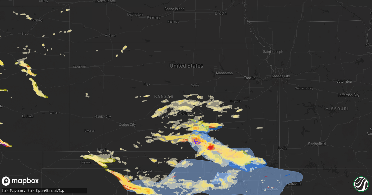
Hail Map in Kansas on June 17, 2025
Get this storm
June 17 map
$229
one time, instant access
Download today. No call, no setup
Keep the $229
Bought the map and want the full workflow? Apply the entire $229 to a subscription within 7 days. None of it is wasted.
Every map, not just this one
This buys you this map. Subscription and you get every map we run, in the markets you choose from a few cities to whole states to nationwide. Plus real-time alerts the moment a storm fires.
Contact data
Name, contact info, occupancy, even credit band for addresses in the footprint. You go from where it hit to who to call.
Become the source they trust
Unlimited branding weather history reports on demand. You already have the documented answer ready for the property owner, and you are the one who showed up with it.
Property data and RoofTrace estimates
Pull up any address you have got, its value and the exact code rules for that jurisdiction, straight from One Click Code. Then RoofTrace estimates the squares, pitch, and roof value, priced the way you price.
Storm reports in Kansas
Kansas
| Date | Description |
|---|---|
| 06/17/20256:45 PM CDT | A local report indicates 1.50 inch wind near Geuda Springs |
| 06/17/20256:15 PM CDT | A local report indicates 60 MPH wind near Leon |
| 06/17/20256:13 PM CDT | 10 inch diameter tree uprooted. |
| 06/17/20256:13 PM CDT | A local report indicates 60 MPH wind near Leon |
| 06/17/20256:10 PM CDT | A local report indicates 1.75 inch wind near 3 E Wellington |
| 06/17/20255:57 PM CDT | A local report indicates 1.75 inch wind near Augusta |
| 06/17/20255:52 PM CDT | A local report indicates 1.00 inch wind near 1 NW Augusta |
| 06/17/20255:52 PM CDT | Power pole snapped and leaning onto a house. |
| 06/17/20255:51 PM CDT | A local report indicates 1.00 inch wind near 1 NW Augusta |
| 06/17/20255:42 PM CDT | A local report indicates 64 MPH wind near 4 SSE Benton |
| 06/17/20255:38 PM CDT | 2 foot diameter trees down. |
| 06/17/20255:35 PM CDT | Awos station k3au augusta municipal airport. |
| 06/17/20255:35 PM CDT | Estimated 80 mph winds along with nickel sized hail. |
| 06/17/20255:34 PM CDT | A local report indicates 2.75 inch wind near 5 SE Conway Springs |
| 06/17/20255:30 PM CDT | Power lines down. |
| 06/17/20255:30 PM CDT | Asos station kict wichita eisenhower airport. |
| 06/17/20255:22 PM CDT | A local report indicates 1.75 inch wind near 4 SSW Conway Springs |
| 06/17/20255:19 PM CDT | A local report indicates 1.00 inch wind near 3 W Andover |
| 06/17/20255:16 PM CDT | A local report indicates 61 MPH wind near Mcconnell Air Force Bas |
| 06/17/20255:13 PM CDT | 60 to 70 mph wind estimate at pawnee and oliver. |
| 06/17/20255:10 PM CDT | A local report indicates 1.25 inch wind near 2 NNW East Wichita |
| 06/17/20255:09 PM CDT | A local report indicates 60 MPH wind near 3 SSE Bel Aire |
| 06/17/20255:08 PM CDT | Several powerlines down throughout the metro. |
| 06/17/20255:06 PM CDT | Six inch diameter branches down. |
| 06/17/20255:01 PM CDT | Overturned semi truck based on view from highway camera. |
| 06/17/20254:59 PM CDT | A local report indicates 1.25 inch wind near Park City |
| 06/17/20254:49 PM CDT | A local report indicates 75 MPH wind near 4 S Maize |
| 06/17/20254:47 PM CDT | Tree limbs down with the 60 mph winds. |
| 06/17/20254:42 PM CDT | Estimated 60 to 70 mph winds near 34th n & ridge rd. |
| 06/17/20254:42 PM CDT | Estim |
| 06/17/20254:41 PM CDT | A local report indicates 62 MPH wind near 2 ESE Maize |
| 06/17/20254:41 PM CDT | A local report indicates a tornado near 1 SSW Harper |
| 06/17/20254:28 PM CDT | A local report indicates 60 MPH wind near Colwich |
| 06/17/20254:26 PM CDT | Law enforcement estimated 70 mph winds and nickel sized hail. |
| 06/17/20254:17 PM CDT | A local report indicates 1.25 inch wind near Mount Hope |
| 06/17/20252:39 PM CDT | A local report indicates 1.00 inch wind near 3 E Sterling |
| 06/17/20252:22 PM CDT | Kake relayed viewer report of quarter sized hail. Time is estimated from radar. |
| 06/17/20257:47 AM CDT | A local report indicates 60 MPH wind near 4 N Clearwater |
| 06/17/20257:40 AM CDT | A local report indicates 60 MPH wind near 4 N Clearwater |
| 06/17/202512:42 AM CDT | A local report indicates 70 MPH wind near Tyro |
| 06/16/202510:59 PM CDT | Asos station kwld strother field airport. |
| 06/16/202510:54 PM CDT | A local report indicates 71 MPH wind near Winfield |
| 06/16/20259:48 PM CDT | A local report indicates 62 MPH wind near 5 SW Conway Springs |
| 06/16/20259:24 PM CDT | A local report indicates 58 MPH wind near 2 N Derby |
| 06/16/20259:20 PM CDT | A local report indicates 59 MPH wind near 3 SE Haysville |
| 06/16/20259:12 PM CDT | A local report indicates 1.00 inch wind near 2 SW Downtown Wichita |
| 06/16/20259:12 PM CDT | Ks storm info estimates 60 to 65 mph and pea to dime sized hail. |
| 06/16/20259:06 PM CDT | Combined with dime sized hail. |
| 06/16/20258:54 PM CDT | Estimates 65 to 70 mph winds. |
| 06/16/20258:54 PM CDT | Estimates 65 to 70 mph winds. |
| 06/16/20258:47 PM CDT | A local report indicates 1.75 inch wind near Goddard |
| 06/16/20258:32 PM CDT | A local report indicates 1.25 inch wind near Garden Plain |
| 06/16/20257:23 PM CDT | A local report indicates 60 MPH wind near 3 W Winfield |
| 06/16/20257:13 PM CDT | A local report indicates 2.00 inch wind near Arkansas City |
| 06/16/20257:07 PM CDT | A local report indicates 3.81 inch wind near Arkansas City |
| 06/16/20257:07 PM CDT | A local report indicates 2.75 inch wind near Arkansas City |
| 06/16/20257:06 PM CDT | A local report indicates 1.75 inch wind near Arkansas City |
| 06/16/20257:03 PM CDT | A local report indicates 1.00 inch wind near Arkansas City |
All States Impacted by Hail Map on June 17, 2025
Cities Impacted by Hail Map on June 17, 2025
- Idalia, CO
- Cope, CO
- Akron, CO
- Yuma, CO
- Fort Collins, CO
- Nunn, CO
- Wellington, CO
- Pawnee, OK
- Cushing, OK
- Ripley, OK
- Stillwater, OK
- Glencoe, OK
- Yale, OK
- Maramec, OK
- Elizabeth, CO
- Parker, CO
- Otis, CO
- Byers, CO
- Wray, CO
- Kiowa, CO
- Woodrow, CO
- Jennings, OK
- Cleveland, OK
- Drumright, OK
- Hominy, OK
- Osage, OK
- Terlton, OK
- Fort Morgan, CO
- Haigler, NE
- Mannford, OK
- Marion, LA
- Murdock, KS
- Cheney, KS
- Deer Trail, CO
- Kingman, KS
- Lindon, CO
- Anton, CO
- Bristow, OK
- Garden Plain, KS
- Viola, KS
- Goddard, KS
- Conway Springs, KS
- Clearwater, KS
- Milton, KS
- Wellington, KS
- Peck, KS
- Belle Plaine, KS
- Haysville, KS
- Wichita, KS
- Derby, KS
- Udall, KS
- Mulvane, KS
- Oxford, KS
- Winfield, KS
- Bastrop, LA
- Pretty Prairie, KS
- Broken Arrow, OK
- Haskell, OK
- Haven, KS
- Mount Hope, KS
- Andale, KS
- Colwich, KS
- Saint Francis, KS
- Mcpherson, KS
- Agate, CO
- Windom, KS
- Galva, KS
- Cedar Vale, KS
- Limon, CO
- Laramie, WY
- Walden, CO
- Genoa, CO
- Lyons, KS
- Chase, KS
- Colorado Springs, CO
- Delaware, OK
- Little River, KS
- Nowata, OK
- Peabody, KS
- Marion, KS
- Hamilton, KS
- Cassoday, KS
- Eureka, KS
- Bazine, KS
- Sedalia, CO
- La Crosse, KS
- Burns, KS
- Florence, KS
- Alexander, KS
- Drake, CO
- Glen Haven, CO
- Virgil, KS
- El Dorado, KS
- Raymond, KS
- Jayess, MS
- Hugo, CO
- Bosler, WY
- Ellinwood, KS
- Hudson, KS
- Bison, KS
- Nekoma, KS
- Rush Center, KS
- Estes Park, CO
- Paris, AR
- Magazine, AR
- Woodland Park, CO
- Divide, CO
- Larned, KS
- St John, KS
- Monument, CO
- Larkspur, CO
- Cedar Point, KS
- Franktown, CO
- Mount Ida, AR
- Hillsboro, KS
- Arriba, CO
- Livermore, CO
- Belpre, KS
- Fountain, CO
- Mena, AR
- Royal, AR
- Lisman, AL
- Laurel, MS
- Cottonwood Falls, KS
- Bellvue, CO
- York, AL
- Ward, AL
- Garfield, KS
- Elbert, CO
- Loveland, CO
- West Point, NE
- Lyons, CO
- Hot Springs National Park, AR
- Hill City, SD
- Macksville, KS
- Matfield Green, KS
- Green Mountain Falls, CO
- Waldron, AR
- Canton, KS
- Alden, KS
- Elk Point, SD
- Manitou Springs, CO
- Peyton, CO
- Carr, CO
- Usaf Academy, CO
- Harvey, AR
- Chatsworth, IA
- Hawarden, IA
- Akron, IA
- Sterling, KS
- Berthoud, CO
- Long Pine, NE
- Geddes, SD
- Newport, NE
- Stuart, NE
- Inman, KS
- Lehigh, KS
- Olpe, KS
- Longmont, CO
- Nickerson, KS
- Hutchinson, KS
- Lead, SD
- Pavillion, WY
- Danville, AR
- Deadwood, SD
- Boulder, CO
- Salemburg, NC
- Roseboro, NC
- Autryville, NC
- Rapid City, SD
- Yoder, CO
- Cascade, CO
- Niwot, CO
- Louisville, CO
- Lafayette, CO
- Broomfield, CO
- Erie, CO
- Timnath, CO
- Windsor, CO
- Plainview, AR
- Sylvia, KS
- Smithville, GA
- Elmdale, KS
- Bluffton, AR
- Chanute, KS
- Vilas, NC
- Beulah, CO
- Goessel, KS
- Erie, KS
- Golden, CO
- Sheridan, AR
- Strong City, KS
- Milliken, CO
- Greeley, CO
- Hartford, KS
- Madison, KS
- Pueblo, CO
- Burns, WY
- Pine Bluffs, WY
- Hermosa, SD
- Keystone, SD
- Plevna, KS
- Fort Lupton, CO
- Platteville, CO
- Custer, SD
- Denver, CO
- Alton, IA
- Orange City, IA
- Platte, SD
- Arvada, CO
- Wheat Ridge, CO
- Zionville, NC
- Lincolnville, KS
- Brighton, CO
- Dacono, CO
- Abbyville, KS
- La Salle, CO
- Atkinson, NE
- Karval, CO
- Gridley, KS
- Leonard, MO
- Shelbyville, MO
- Henderson, CO
- Roscoe, MT
- Commerce City, CO
- Bushnell, NE
- Buhler, KS
- Bethel, MO
- Edgemont, SD
- Partridge, KS
- Grover, CO
- Fairburn, SD
- Westminster, CO
- Thornton, CO
- Kaycee, WY
- Boone, CO
- Sterling, CO
- Lance Creek, WY
- Anabel, MO
- Aurora, CO
- Colorado City, CO
- Hudson, CO
- Fishtail, MT
- Beattyville, KY
- Jackson, KY
- Haswell, CO
- Cheyenne, WY
- Hillsdale, WY
- Rye, CO
- Merino, CO
- Douglas, WY
- Le Mars, IA
- Stoneham, CO
- Buffalo Gap, SD
- Lusk, WY
- Gillette, WY
- Attica, KS
- Hot Springs, SD
- Slaughter, LA
- Lake, MS
- Remsen, IA
- Harper, KS
- Winner, SD
- Colome, SD
- Kingsley, IA
- Clinton, LA
- Glenrock, WY
- Cunningham, KS
- Walsenburg, CO
- Musella, GA
- Van Tassell, WY
- Lost Springs, WY
- Manville, WY
- Ewing, MO
- Taylor, MO
- Maywood, MO
- Burrton, KS
- Kit Carson, CO
- Oral, SD
- Maize, KS
- Sedgwick, KS
- Bentley, KS
- Arlington, KS
- Danville, KS
- Wesson, MS
- Lu Verne, IA
- Livermore, IA
- Hazlehurst, MS
- La Grange, MO
- Valley Center, KS
- Norwich, KS
- Argonia, KS
- Eads, CO
- Corwith, IA
- Renwick, IA
- Ovid, CO
- Quincy, IL
- Payson, IL
- Palmyra, MO
- Mcconnell Afb, KS
- Medicine Lodge, KS
- Lake City, KS
- Ursa, IL
- Kechi, KS
- Aguilar, CO
- Trinidad, CO
- Mystic, IA
- Julesburg, CO
- Pocahontas, IA
- Mayersville, MS
- Dalton, NE
- Andover, KS
- Milan, KS
- Rose Hill, KS
- Mission, SD
- Woodland, MS
- Cedarbluff, MS
- Newcastle, WY
- Rock River, WY
- Isabel, KS
- Pine Ridge, SD
- Mayfield, KS
- Fowler, IL
- Nashville, KS
- Bentonia, MS
- Greenwich, KS
- Benton, KS
- Smithdale, MS
- Summit, MS
- Turon, KS
- Augusta, KS
- Towanda, KS
- Douglass, KS
- Bogue Chitto, MS
- Brookhaven, MS
- Yazoo City, MS
- Benton, MS
- Sharon, KS
- Hooker, OK
- Tryon, NE
- Mullen, NE
- Shawnee, WY
- South Haven, KS
- Leon, KS
- Trinchera, CO
- Norcatur, KS
- Newell, SD
- Plymouth, IL
- Tennessee, IL
- Merriman, NE
- Zenda, KS
- Rushville, NE
- Caldwell, KS
- Port Gibson, MS
- Stratton, NE
- Spivey, KS
- Norton, KS
- Batesland, SD
- Madrid, NE
- Grant, NE
- Valentine, NE
- Anthony, KS
- Vicksburg, MS
- Claflin, KS
- Balko, OK
- Floydada, TX
- Hardesty, OK
- Trenton, NE
- Belle Fourche, SD
- Peerless, MT
- Macclenny, FL
- Geuda Springs, KS
- Rosalia, KS
- Lorenzo, TX
- Ralls, TX
- Crosbyton, TX
- Ropesville, TX
- Levelland, TX
- Harrison, NE
- Miller, SD
- Palisade, NE
- Lindsborg, KS
- Elsie, NE
- Wauneta, NE
- Leoti, KS
- Bushton, KS
- Glen Saint Mary, FL
- Marquette, KS
- Great Bend, KS
- Hayes Center, NE
- Hemingford, NE
- Marsland, NE
- Arkansas City, KS
- Gordon, NE
- Perryton, TX
- Keenesburg, CO
- Evans, CO
- Florissant, CO
- Johnstown, CO
- Mead, CO
- Crookston, NE
- Wolfforth, TX
- Kersey, CO
- Booker, TX
- Frederick, CO
- Firestone, CO
- Ellsworth, KS
- Lubbock, TX
- Atwood, KS
- Saint George, GA
- Cody, NE
- Geneseo, KS
- Medford, OK
- Braman, OK
- Greeneville, TN
- Tampa, KS
- Ramona, KS
- Culbertson, NE
- Durham, KS
- Gypsum, KS
- Sanderson, FL
- Wilson, TX
- Tahoka, TX
- Nichols, IA
- West Liberty, IA
- Dexter, KS
- Nardin, OK
- Maple City, KS
- Moundridge, KS
- Newkirk, OK
- Higgins, TX
- Lipscomb, TX
- Canadian, TX
- Follett, TX
- Lost Springs, KS
- Portland, MO
- Eureka, SD
- Bingham, NE
- Mcadoo, TX
- Roxbury, KS
- Blackwell, OK
- Shidler, OK
- Dresden, KS
- Jennings, KS
- Shattuck, OK
- Ionia, IA
- Chuckey, TN
- Ellsworth, NE
- Slaton, TX
- Kinsman, IL
- Stafford, KS
- Arnett, OK
- Ponca City, OK
- Sharon, OK
- Rogersville, TN
- Kaw City, OK
- Kingsport, TN
- Church Hill, TN
- Halstead, KS
- Durham, OK
- Crawford, OK
- Newton, KS
- Sun City, KS
- Coats, KS
- Haviland, KS
- Post, TX
- Freedom, OK
- Mooreland, OK
- Dickens, TX
- Spur, TX
- Lone Tree, IA
- Mount Carmel, TN
- Pawhuska, OK
- Thedford, NE
- Burbank, OK
- Peru, KS
- Bartlesville, OK
- Sedan, KS
- Wynona, OK
- Waynoka, OK
- Pratt, KS
- Vici, OK
- Leedey, OK
- Cheyenne, OK
- Guymon, OK
- Dacoma, OK
- Alva, OK
- Sawyer, KS
- Leasburg, MO
- Bourbon, MO
- Hammon, OK
- Taloga, OK
- Camargo, OK
- Seiling, OK
- Afton, TX
- Cherokee, OK
- Carmen, OK
- Mutual, OK
- Coldwater, KS
- Wilmore, KS
- New Haven, MO
- Barnsdall, OK
- Caney, KS
- Copan, OK
- Niotaze, KS
- Thomson, IL
- Butler, OK
- Nash, OK
- Newark, IL
- Sheridan, IL
- Millington, IL
- Custer City, OK
- Putnam, OK
- Longdale, OK
- Chester, OK
- Oakwood, OK
- Fairview, OK
- Turpin, OK
- Wann, OK
- Ramona, OK
- Dewey, OK
- Ochelata, OK
- Lenapah, OK
- Millbrook, IL
- Yorkville, IL
- Helena, OK
- Meade, KS
- Pond Creek, OK
- Goltry, OK
- Waldron, KS
- Tyrone, OK
- Ashland, KS
- Oologah, OK
- Collinsville, OK
- Vera, OK
- Skiatook, OK
- Talala, OK
- Ringwood, OK
- Cleo Springs, OK
- Jet, OK
- Aline, OK
- Thomas, OK
- Canton, OK
- Ames, OK
- Hitchcock, OK
- Watonga, OK
- Okeene, OK
- Isabella, OK
- Southard, OK
- Fay, OK
- Carrier, OK
- Lahoma, OK
- Meno, OK
- Enid, OK
- Liberal, KS
- Kismet, KS
- Beaver, OK
- Kremlin, OK
- Freeport, KS
- Chelsea, OK
- Claremore, OK
- Vinita, OK
- Geary, OK
- Greenfield, OK
- Weatherford, OK
- Kingfisher, OK
- Hennessey, OK
- Drummond, OK
- Okarche, OK
- Omega, OK
- Loyal, OK
- Calumet, OK
- Waukomis, OK
- Bison, OK
- Forgan, OK
- Iuka, KS
- Lamont, OK
- Hunter, OK
- Covington, OK
- Fairmont, OK
- Billings, OK
- Dover, OK
- Garber, OK
- Douglas, OK
- Marshall, OK
- Crescent, OK
- Adair, OK
- Big Cabin, OK
- Bluejacket, OK
- Gate, OK
- Laverne, OK
- Atlanta, KS
- Bluff City, KS
- Yukon, OK
- El Reno, OK
- Cashion, OK
- Piedmont, OK
- Tonkawa, OK
- Edmond, OK
- Guthrie, OK
- Verona, IL
- Protection, KS
- Englewood, KS
- Wakita, OK
- Perry, OK
- Orlando, OK
- Mulhall, OK
- Lucien, OK
- Bethany, OK
- Oklahoma City, OK
- Coyle, OK
- Red Rock, OK
- Morrison, OK
- Marland, OK
- Burden, KS
- Fargo, OK
- Woodward, OK
- Spencer, OK
- Perkins, OK
- Meridian, OK
- Luther, OK
- Wellston, OK
- Tryon, OK
- Chandler, OK
- Carney, OK
- Agra, OK
- Ralston, OK
- Fairfax, OK
- Cambridge, KS
- Jones, OK
- Choctaw, OK
- Harrah, OK
- Arcadia, OK
- Depew, OK
- Stroud, OK
- Davenport, OK
- Sand Springs, OK
- Sapulpa, OK
- Kellyville, OK
- Prue, OK
- Sperry, OK
- Tulsa, OK
- Kiefer, OK
- Mounds, OK
- Beggs, OK
- Glenpool, OK
- Okmulgee, OK
- Inola, OK
- Catoosa, OK
- Jenks, OK
- Bixby, OK
- Owasso, OK
- Chautauqua, KS
- Independence, KS
- Tyro, KS
- Coffeyville, KS
- S Coffeyville, OK
- Havana, KS
- Dearing, KS
- Salina, OK
- Rose, OK
- Pryor, OK
- Coweta, OK
- Hulbert, OK
- Muskogee, OK
- Chouteau, OK
- Spavinaw, OK
- Wagoner, OK
- Fort Gibson, OK
- Porter, OK
- Boynton, OK
- Strang, OK
- Oktaha, OK
- Taft, OK
- Locust Grove, OK
- Redbird, OK
- Morris, OK
- Afton, OK
- Peggs, OK
- Tahlequah, OK
- Proctor, OK
- Braggs, OK
- Vian, OK
- Park Hill, OK
- Gore, OK
- Colcord, OK
- Ketchum, OK
- Welling, OK
- Twin Oaks, OK
- Eucha, OK
- Siloam Springs, AR
- Jay, OK
- Summers, AR
- Gravette, AR
- Bunch, OK
- Westville, OK
- Gentry, AR
- Oaks, OK
- Watts, OK
- Kansas, OK
- Stilwell, OK
- Sulphur Springs, AR
- Maysville, AR
- Grove, OK
- Cookson, OK
- Decatur, AR
- Fayetteville, AR
- Lincoln, AR
- Bentonville, AR
- Hiwasse, AR
- Centerton, AR
- Springdale, AR
- Malvern, AR
- Arapaho, OK
- Newalla, OK
- Mcloud, OK
- Hinton, OK
- Hydro, OK
- Lookeba, OK
- Sentinel, OK
- Union City, OK
- Cimarron, NM
- Binger, OK
- Minco, OK
- Anadarko, OK
- Tuttle, OK
- Lonsdale, AR
- Newcastle, OK
- Pocasset, OK
- Williamsburg, MO
- Steelville, MO
- Durham, MO
- Cook Sta, MO
- Amber, OK
- Blanchard, OK
- Clarence, MO
- Monroe City, MO
- Benton, AR
- Norman, OK
- Shawnee, OK
- Greenwood, IN
- Indianapolis, IN
- Alexander, AR
- Little Rock, AR
- Earlsboro, OK
- Seminole, OK
- Washington, OK
- Huntsville, AR
- Hindsville, AR
- Rogers, AR
- Prairie Grove, AR
- Cave Springs, AR
- Lowell, AR
- Bella Vista, AR
- Eureka Springs, AR
- Garfield, AR
- Pea Ridge, AR
- Starr, SC
- Anderson, SC
- Belton, SC
- Williamston, SC
- Pelzer, SC
- Woodruff, SC
- Greer, SC
- Duncan, SC
- Moore, SC
- Spartanburg, SC
- Roebuck, SC
- Gaffney, SC
- Pacolet, SC
- Glendale, SC
- Cowpens, SC
- Monetta, SC
- Batesburg, SC
- Ridge Spring, SC
- Leesville, SC
- Gilbert, SC
- Lexington, SC
- Columbia, SC
- Irmo, SC
- West Columbia, SC
- Gaston, SC
- Cayce, SC
- Talladega, AL
- Lincoln, AL
- Munford, AL
- Eastaboga, AL
- Weaver, AL
- Anniston, AL
- Oxford, AL
- Heflin, AL
- Jacksonville, AL
- Piedmont, AL
- Fruithurst, AL
- Muscadine, AL
- Cedartown, GA
- Tallapoosa, GA
- Buchanan, GA
- Decatur, GA
- Scottdale, GA
- Clarkston, GA
- Avondale Estates, GA
- Tucker, GA
- Stone Mountain, GA
- Lithonia, GA
- Pine Lake, GA
- Norcross, GA
- Lilburn, GA
- Lawrenceville, GA
- Snellville, GA
- Suwanee, GA
- Duluth, GA
- Dacula, GA
- Auburn, GA
- Buford, GA
- Hoschton, GA
- Braselton, GA
- Winder, GA
- Jefferson, GA
- Oxford, GA
- Covington, GA
- Loganville, GA
- Monroe, GA
- Social Circle, GA
- Bogart, GA
- Good Hope, GA
- Bishop, GA
- Madison, GA
- Sherwood, AR
- North Little Rock, AR


