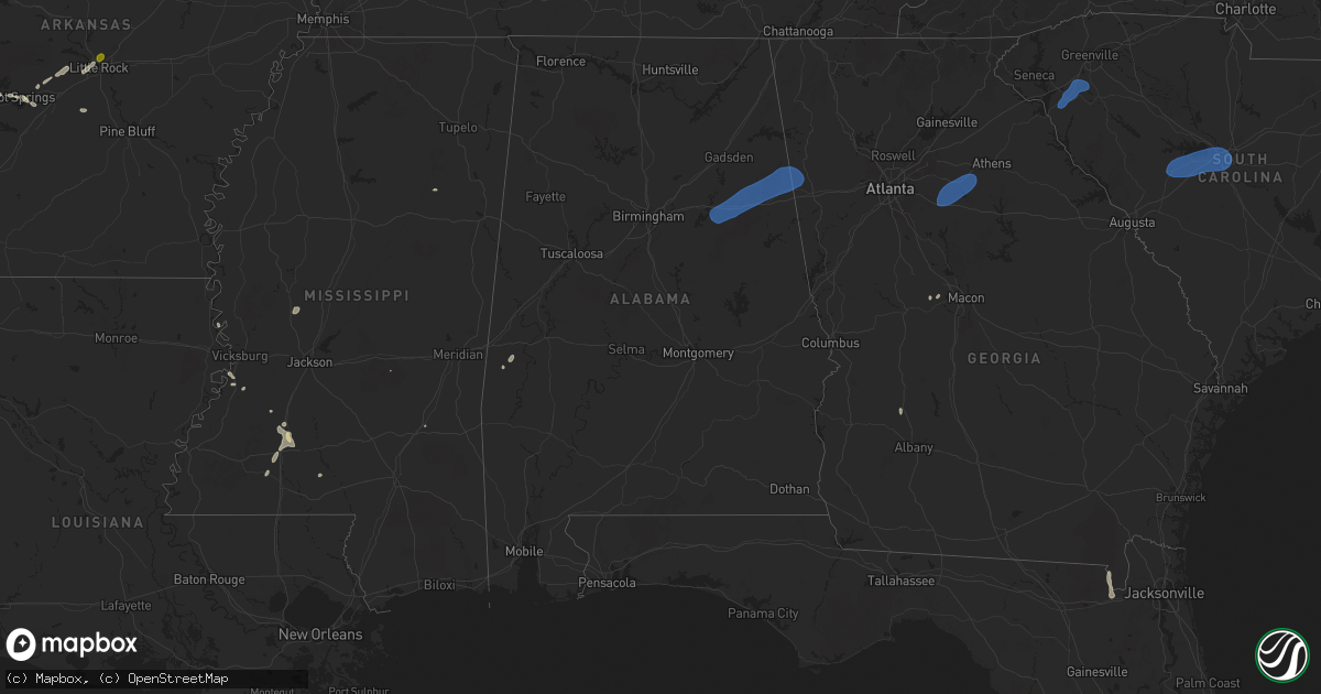
Hail Map in Alabama on June 17, 2025
Get this storm
June 17 map
$229
one time, instant access
Download today. No call, no setup
Keep the $229
Bought the map and want the full workflow? Apply the entire $229 to a subscription within 7 days. None of it is wasted.
Every map, not just this one
This buys you this map. Subscription and you get every map we run, in the markets you choose from a few cities to whole states to nationwide. Plus real-time alerts the moment a storm fires.
Contact data
Name, contact info, occupancy, even credit band for addresses in the footprint. You go from where it hit to who to call.
Become the source they trust
Unlimited branding weather history reports on demand. You already have the documented answer ready for the property owner, and you are the one who showed up with it.
Property data and RoofTrace estimates
Pull up any address you have got, its value and the exact code rules for that jurisdiction, straight from One Click Code. Then RoofTrace estimates the squares, pitch, and roof value, priced the way you price.
Storm reports in Alabama
Alabama
| Date | Description |
|---|---|
| 06/17/20256:49 PM CDT | A tree was knocked down at 561 mill creek loop. Time estimated by radar. |
| 06/17/20256:49 PM CDT | A tree was knocked down at 561 mill creek loop. Time estimated by radar. |
| 06/17/20256:45 PM CDT | Corrects previous tstm wnd dmg report from 1 se cherokee. A tree was knocked down at 19 u.s. Highway 72. Time estimated by radar. |
| 06/17/20256:34 PM CDT | Corrects previous tstm wnd dmg report from 4 wnw cherokee. A tree was knocked down at 561 mill creek loop. Time estimated by radar. |
| 06/17/20255:45 PM CDT | Corrects previous tstm wnd dmg report from 3 ssw leighton. A power pole was knocked down at 2780 highway 157. Time estimated by radar. |
| 06/17/20255:45 PM CDT | A tree was knocked down blocking the entire roadway at the intersection of townsell lane and cr 83. Time estimated by radar. |
| 06/17/20255:19 PM CDT | Corrects previous tstm wnd dmg report from 9 nw russellville. A tree was knocked down at 4525 jones road. Time estimated by radar. |
| 06/17/20255:18 PM CDT | Corrects previous tstm wnd dmg report from 6 w lexington. A tree was knocked down blocking both lanes at the intersection of cr 33 and cr 39. Time estimated by radar. |
| 06/17/20254:54 PM CDT | A tree was knocked down onto cr 25 at cr 170 blocking the northbound lane. Time estimated by radar. |
| 06/17/20254:48 PM CDT | Corrects previous tstm wnd dmg report from 3 ene saint florian. A tree was knocked down just past mt. Zion church near the intersection of cr 27 and cr 122 blocking 3 q |
| 06/17/20254:48 PM CDT | Corrects previous tstm wnd dmg report from 3 e saint florian. A tree was knocked down at the intersection of cr 27 and cr 30. Another tree was leaning over the road. Ti |
| 06/17/20254:43 PM CDT | Corrects previous tstm wnd dmg report from 5 e waterloo. A tree was knocked down blocking the entire roadway at the intersection of townsell l |
| 06/17/20254:43 PM CDT | Corrects previous tstm wnd dmg report from 5 e waterloo. A tree was knocked down blocking the entire roadway at the intersection of townsell lane and cr 83. Time estima |
| 06/17/20254:10 PM CDT | Corrects previous tstm wnd dmg report from 3 n killen. A tree was knocked down onto cr 25 at cr 170 blocking the northbound lane. Time estimated by radar. |
| 06/17/20253:52 PM CDT | A couple trees down in the fruithurst area. |
| 06/17/20253:40 PM CDT | A couple trees down in the heflin area. |
| 06/17/20253:20 PM CDT | Numerous trees down across anniston... Including quintard ave... Rainbow cir... Conger rd... M st... And interstate 20. |
| 06/17/20253:04 PM CDT | A couple trees down in perry county... Including along highway 219. |
| 06/17/20252:55 PM CDT | Several trees down around talladega county... Mainly in and around the city of talladega. |
| 06/17/20252:18 PM CDT | Tree uprooted onto powerline. Time estimated based on radar. |
| 06/16/20257:54 PM CDT | A tree was knocked down at 19 u.s. Highway 72. Time estimated by radar. |
| 06/16/20257:32 PM CDT | A power pole was knocked down at 2780 highway 157. Time estimated by radar. |
| 06/16/20257:28 PM CDT | A tree was knocked down at 4525 jones road. Time estimated by radar. |
| 06/16/20257:12 PM CDT | A tree was knocked down blocking both lanes at the intersection of cr 33 and cr 39. Time estimated by radar. |
| 06/16/20257:10 PM CDT | A tree was knocked down just past mt. Zion church near the intersection of cr 27 and cr 122 blocking 3 quarters of the roadway. Time estimated by radar. |
| 06/16/20257:10 PM CDT | A tree was knocked down at the intersection of cr 27 and cr 30. Another tree was leaning over the road. Time estimated by radar. |
All States Impacted by Hail Map on June 17, 2025
Cities Impacted by Hail Map on June 17, 2025
- Idalia, CO
- Cope, CO
- Akron, CO
- Yuma, CO
- Fort Collins, CO
- Nunn, CO
- Wellington, CO
- Pawnee, OK
- Cushing, OK
- Ripley, OK
- Stillwater, OK
- Glencoe, OK
- Yale, OK
- Maramec, OK
- Elizabeth, CO
- Parker, CO
- Otis, CO
- Byers, CO
- Wray, CO
- Kiowa, CO
- Woodrow, CO
- Jennings, OK
- Cleveland, OK
- Drumright, OK
- Hominy, OK
- Osage, OK
- Terlton, OK
- Fort Morgan, CO
- Haigler, NE
- Mannford, OK
- Marion, LA
- Murdock, KS
- Cheney, KS
- Deer Trail, CO
- Kingman, KS
- Lindon, CO
- Anton, CO
- Bristow, OK
- Garden Plain, KS
- Viola, KS
- Goddard, KS
- Conway Springs, KS
- Clearwater, KS
- Milton, KS
- Wellington, KS
- Peck, KS
- Belle Plaine, KS
- Haysville, KS
- Wichita, KS
- Derby, KS
- Udall, KS
- Mulvane, KS
- Oxford, KS
- Winfield, KS
- Bastrop, LA
- Pretty Prairie, KS
- Broken Arrow, OK
- Haskell, OK
- Haven, KS
- Mount Hope, KS
- Andale, KS
- Colwich, KS
- Saint Francis, KS
- Mcpherson, KS
- Agate, CO
- Windom, KS
- Galva, KS
- Cedar Vale, KS
- Limon, CO
- Laramie, WY
- Walden, CO
- Genoa, CO
- Lyons, KS
- Chase, KS
- Colorado Springs, CO
- Delaware, OK
- Little River, KS
- Nowata, OK
- Peabody, KS
- Marion, KS
- Hamilton, KS
- Cassoday, KS
- Eureka, KS
- Bazine, KS
- Sedalia, CO
- La Crosse, KS
- Burns, KS
- Florence, KS
- Alexander, KS
- Drake, CO
- Glen Haven, CO
- Virgil, KS
- El Dorado, KS
- Raymond, KS
- Jayess, MS
- Hugo, CO
- Bosler, WY
- Ellinwood, KS
- Hudson, KS
- Bison, KS
- Nekoma, KS
- Rush Center, KS
- Estes Park, CO
- Paris, AR
- Magazine, AR
- Woodland Park, CO
- Divide, CO
- Larned, KS
- St John, KS
- Monument, CO
- Larkspur, CO
- Cedar Point, KS
- Franktown, CO
- Mount Ida, AR
- Hillsboro, KS
- Arriba, CO
- Livermore, CO
- Belpre, KS
- Fountain, CO
- Mena, AR
- Royal, AR
- Lisman, AL
- Laurel, MS
- Cottonwood Falls, KS
- Bellvue, CO
- York, AL
- Ward, AL
- Garfield, KS
- Elbert, CO
- Loveland, CO
- West Point, NE
- Lyons, CO
- Hot Springs National Park, AR
- Hill City, SD
- Macksville, KS
- Matfield Green, KS
- Green Mountain Falls, CO
- Waldron, AR
- Canton, KS
- Alden, KS
- Elk Point, SD
- Manitou Springs, CO
- Peyton, CO
- Carr, CO
- Usaf Academy, CO
- Harvey, AR
- Chatsworth, IA
- Hawarden, IA
- Akron, IA
- Sterling, KS
- Berthoud, CO
- Long Pine, NE
- Geddes, SD
- Newport, NE
- Stuart, NE
- Inman, KS
- Lehigh, KS
- Olpe, KS
- Longmont, CO
- Nickerson, KS
- Hutchinson, KS
- Lead, SD
- Pavillion, WY
- Danville, AR
- Deadwood, SD
- Boulder, CO
- Salemburg, NC
- Roseboro, NC
- Autryville, NC
- Rapid City, SD
- Yoder, CO
- Cascade, CO
- Niwot, CO
- Louisville, CO
- Lafayette, CO
- Broomfield, CO
- Erie, CO
- Timnath, CO
- Windsor, CO
- Plainview, AR
- Sylvia, KS
- Smithville, GA
- Elmdale, KS
- Bluffton, AR
- Chanute, KS
- Vilas, NC
- Beulah, CO
- Goessel, KS
- Erie, KS
- Golden, CO
- Sheridan, AR
- Strong City, KS
- Milliken, CO
- Greeley, CO
- Hartford, KS
- Madison, KS
- Pueblo, CO
- Burns, WY
- Pine Bluffs, WY
- Hermosa, SD
- Keystone, SD
- Plevna, KS
- Fort Lupton, CO
- Platteville, CO
- Custer, SD
- Denver, CO
- Alton, IA
- Orange City, IA
- Platte, SD
- Arvada, CO
- Wheat Ridge, CO
- Zionville, NC
- Lincolnville, KS
- Brighton, CO
- Dacono, CO
- Abbyville, KS
- La Salle, CO
- Atkinson, NE
- Karval, CO
- Gridley, KS
- Leonard, MO
- Shelbyville, MO
- Henderson, CO
- Roscoe, MT
- Commerce City, CO
- Bushnell, NE
- Buhler, KS
- Bethel, MO
- Edgemont, SD
- Partridge, KS
- Grover, CO
- Fairburn, SD
- Westminster, CO
- Thornton, CO
- Kaycee, WY
- Boone, CO
- Sterling, CO
- Lance Creek, WY
- Anabel, MO
- Aurora, CO
- Colorado City, CO
- Hudson, CO
- Fishtail, MT
- Beattyville, KY
- Jackson, KY
- Haswell, CO
- Cheyenne, WY
- Hillsdale, WY
- Rye, CO
- Merino, CO
- Douglas, WY
- Le Mars, IA
- Stoneham, CO
- Buffalo Gap, SD
- Lusk, WY
- Gillette, WY
- Attica, KS
- Hot Springs, SD
- Slaughter, LA
- Lake, MS
- Remsen, IA
- Harper, KS
- Winner, SD
- Colome, SD
- Kingsley, IA
- Clinton, LA
- Glenrock, WY
- Cunningham, KS
- Walsenburg, CO
- Musella, GA
- Van Tassell, WY
- Lost Springs, WY
- Manville, WY
- Ewing, MO
- Taylor, MO
- Maywood, MO
- Burrton, KS
- Kit Carson, CO
- Oral, SD
- Maize, KS
- Sedgwick, KS
- Bentley, KS
- Arlington, KS
- Danville, KS
- Wesson, MS
- Lu Verne, IA
- Livermore, IA
- Hazlehurst, MS
- La Grange, MO
- Valley Center, KS
- Norwich, KS
- Argonia, KS
- Eads, CO
- Corwith, IA
- Renwick, IA
- Ovid, CO
- Quincy, IL
- Payson, IL
- Palmyra, MO
- Mcconnell Afb, KS
- Medicine Lodge, KS
- Lake City, KS
- Ursa, IL
- Kechi, KS
- Aguilar, CO
- Trinidad, CO
- Mystic, IA
- Julesburg, CO
- Pocahontas, IA
- Mayersville, MS
- Dalton, NE
- Andover, KS
- Milan, KS
- Rose Hill, KS
- Mission, SD
- Woodland, MS
- Cedarbluff, MS
- Newcastle, WY
- Rock River, WY
- Isabel, KS
- Pine Ridge, SD
- Mayfield, KS
- Fowler, IL
- Nashville, KS
- Bentonia, MS
- Greenwich, KS
- Benton, KS
- Smithdale, MS
- Summit, MS
- Turon, KS
- Augusta, KS
- Towanda, KS
- Douglass, KS
- Bogue Chitto, MS
- Brookhaven, MS
- Yazoo City, MS
- Benton, MS
- Sharon, KS
- Hooker, OK
- Tryon, NE
- Mullen, NE
- Shawnee, WY
- South Haven, KS
- Leon, KS
- Trinchera, CO
- Norcatur, KS
- Newell, SD
- Plymouth, IL
- Tennessee, IL
- Merriman, NE
- Zenda, KS
- Rushville, NE
- Caldwell, KS
- Port Gibson, MS
- Stratton, NE
- Spivey, KS
- Norton, KS
- Batesland, SD
- Madrid, NE
- Grant, NE
- Valentine, NE
- Anthony, KS
- Vicksburg, MS
- Claflin, KS
- Balko, OK
- Floydada, TX
- Hardesty, OK
- Trenton, NE
- Belle Fourche, SD
- Peerless, MT
- Macclenny, FL
- Geuda Springs, KS
- Rosalia, KS
- Lorenzo, TX
- Ralls, TX
- Crosbyton, TX
- Ropesville, TX
- Levelland, TX
- Harrison, NE
- Miller, SD
- Palisade, NE
- Lindsborg, KS
- Elsie, NE
- Wauneta, NE
- Leoti, KS
- Bushton, KS
- Glen Saint Mary, FL
- Marquette, KS
- Great Bend, KS
- Hayes Center, NE
- Hemingford, NE
- Marsland, NE
- Arkansas City, KS
- Gordon, NE
- Perryton, TX
- Keenesburg, CO
- Evans, CO
- Florissant, CO
- Johnstown, CO
- Mead, CO
- Crookston, NE
- Wolfforth, TX
- Kersey, CO
- Booker, TX
- Frederick, CO
- Firestone, CO
- Ellsworth, KS
- Lubbock, TX
- Atwood, KS
- Saint George, GA
- Cody, NE
- Geneseo, KS
- Medford, OK
- Braman, OK
- Greeneville, TN
- Tampa, KS
- Ramona, KS
- Culbertson, NE
- Durham, KS
- Gypsum, KS
- Sanderson, FL
- Wilson, TX
- Tahoka, TX
- Nichols, IA
- West Liberty, IA
- Dexter, KS
- Nardin, OK
- Maple City, KS
- Moundridge, KS
- Newkirk, OK
- Higgins, TX
- Lipscomb, TX
- Canadian, TX
- Follett, TX
- Lost Springs, KS
- Portland, MO
- Eureka, SD
- Bingham, NE
- Mcadoo, TX
- Roxbury, KS
- Blackwell, OK
- Shidler, OK
- Dresden, KS
- Jennings, KS
- Shattuck, OK
- Ionia, IA
- Chuckey, TN
- Ellsworth, NE
- Slaton, TX
- Kinsman, IL
- Stafford, KS
- Arnett, OK
- Ponca City, OK
- Sharon, OK
- Rogersville, TN
- Kaw City, OK
- Kingsport, TN
- Church Hill, TN
- Halstead, KS
- Durham, OK
- Crawford, OK
- Newton, KS
- Sun City, KS
- Coats, KS
- Haviland, KS
- Post, TX
- Freedom, OK
- Mooreland, OK
- Dickens, TX
- Spur, TX
- Lone Tree, IA
- Mount Carmel, TN
- Pawhuska, OK
- Thedford, NE
- Burbank, OK
- Peru, KS
- Bartlesville, OK
- Sedan, KS
- Wynona, OK
- Waynoka, OK
- Pratt, KS
- Vici, OK
- Leedey, OK
- Cheyenne, OK
- Guymon, OK
- Dacoma, OK
- Alva, OK
- Sawyer, KS
- Leasburg, MO
- Bourbon, MO
- Hammon, OK
- Taloga, OK
- Camargo, OK
- Seiling, OK
- Afton, TX
- Cherokee, OK
- Carmen, OK
- Mutual, OK
- Coldwater, KS
- Wilmore, KS
- New Haven, MO
- Barnsdall, OK
- Caney, KS
- Copan, OK
- Niotaze, KS
- Thomson, IL
- Butler, OK
- Nash, OK
- Newark, IL
- Sheridan, IL
- Millington, IL
- Custer City, OK
- Putnam, OK
- Longdale, OK
- Chester, OK
- Oakwood, OK
- Fairview, OK
- Turpin, OK
- Wann, OK
- Ramona, OK
- Dewey, OK
- Ochelata, OK
- Lenapah, OK
- Millbrook, IL
- Yorkville, IL
- Helena, OK
- Meade, KS
- Pond Creek, OK
- Goltry, OK
- Waldron, KS
- Tyrone, OK
- Ashland, KS
- Oologah, OK
- Collinsville, OK
- Vera, OK
- Skiatook, OK
- Talala, OK
- Ringwood, OK
- Cleo Springs, OK
- Jet, OK
- Aline, OK
- Thomas, OK
- Canton, OK
- Ames, OK
- Hitchcock, OK
- Watonga, OK
- Okeene, OK
- Isabella, OK
- Southard, OK
- Fay, OK
- Carrier, OK
- Lahoma, OK
- Meno, OK
- Enid, OK
- Liberal, KS
- Kismet, KS
- Beaver, OK
- Kremlin, OK
- Freeport, KS
- Chelsea, OK
- Claremore, OK
- Vinita, OK
- Geary, OK
- Greenfield, OK
- Weatherford, OK
- Kingfisher, OK
- Hennessey, OK
- Drummond, OK
- Okarche, OK
- Omega, OK
- Loyal, OK
- Calumet, OK
- Waukomis, OK
- Bison, OK
- Forgan, OK
- Iuka, KS
- Lamont, OK
- Hunter, OK
- Covington, OK
- Fairmont, OK
- Billings, OK
- Dover, OK
- Garber, OK
- Douglas, OK
- Marshall, OK
- Crescent, OK
- Adair, OK
- Big Cabin, OK
- Bluejacket, OK
- Gate, OK
- Laverne, OK
- Atlanta, KS
- Bluff City, KS
- Yukon, OK
- El Reno, OK
- Cashion, OK
- Piedmont, OK
- Tonkawa, OK
- Edmond, OK
- Guthrie, OK
- Verona, IL
- Protection, KS
- Englewood, KS
- Wakita, OK
- Perry, OK
- Orlando, OK
- Mulhall, OK
- Lucien, OK
- Bethany, OK
- Oklahoma City, OK
- Coyle, OK
- Red Rock, OK
- Morrison, OK
- Marland, OK
- Burden, KS
- Fargo, OK
- Woodward, OK
- Spencer, OK
- Perkins, OK
- Meridian, OK
- Luther, OK
- Wellston, OK
- Tryon, OK
- Chandler, OK
- Carney, OK
- Agra, OK
- Ralston, OK
- Fairfax, OK
- Cambridge, KS
- Jones, OK
- Choctaw, OK
- Harrah, OK
- Arcadia, OK
- Depew, OK
- Stroud, OK
- Davenport, OK
- Sand Springs, OK
- Sapulpa, OK
- Kellyville, OK
- Prue, OK
- Sperry, OK
- Tulsa, OK
- Kiefer, OK
- Mounds, OK
- Beggs, OK
- Glenpool, OK
- Okmulgee, OK
- Inola, OK
- Catoosa, OK
- Jenks, OK
- Bixby, OK
- Owasso, OK
- Chautauqua, KS
- Independence, KS
- Tyro, KS
- Coffeyville, KS
- S Coffeyville, OK
- Havana, KS
- Dearing, KS
- Salina, OK
- Rose, OK
- Pryor, OK
- Coweta, OK
- Hulbert, OK
- Muskogee, OK
- Chouteau, OK
- Spavinaw, OK
- Wagoner, OK
- Fort Gibson, OK
- Porter, OK
- Boynton, OK
- Strang, OK
- Oktaha, OK
- Taft, OK
- Locust Grove, OK
- Redbird, OK
- Morris, OK
- Afton, OK
- Peggs, OK
- Tahlequah, OK
- Proctor, OK
- Braggs, OK
- Vian, OK
- Park Hill, OK
- Gore, OK
- Colcord, OK
- Ketchum, OK
- Welling, OK
- Twin Oaks, OK
- Eucha, OK
- Siloam Springs, AR
- Jay, OK
- Summers, AR
- Gravette, AR
- Bunch, OK
- Westville, OK
- Gentry, AR
- Oaks, OK
- Watts, OK
- Kansas, OK
- Stilwell, OK
- Sulphur Springs, AR
- Maysville, AR
- Grove, OK
- Cookson, OK
- Decatur, AR
- Fayetteville, AR
- Lincoln, AR
- Bentonville, AR
- Hiwasse, AR
- Centerton, AR
- Springdale, AR
- Malvern, AR
- Arapaho, OK
- Newalla, OK
- Mcloud, OK
- Hinton, OK
- Hydro, OK
- Lookeba, OK
- Sentinel, OK
- Union City, OK
- Cimarron, NM
- Binger, OK
- Minco, OK
- Anadarko, OK
- Tuttle, OK
- Lonsdale, AR
- Newcastle, OK
- Pocasset, OK
- Williamsburg, MO
- Steelville, MO
- Durham, MO
- Cook Sta, MO
- Amber, OK
- Blanchard, OK
- Clarence, MO
- Monroe City, MO
- Benton, AR
- Norman, OK
- Shawnee, OK
- Greenwood, IN
- Indianapolis, IN
- Alexander, AR
- Little Rock, AR
- Earlsboro, OK
- Seminole, OK
- Washington, OK
- Huntsville, AR
- Hindsville, AR
- Rogers, AR
- Prairie Grove, AR
- Cave Springs, AR
- Lowell, AR
- Bella Vista, AR
- Eureka Springs, AR
- Garfield, AR
- Pea Ridge, AR
- Starr, SC
- Anderson, SC
- Belton, SC
- Williamston, SC
- Pelzer, SC
- Woodruff, SC
- Greer, SC
- Duncan, SC
- Moore, SC
- Spartanburg, SC
- Roebuck, SC
- Gaffney, SC
- Pacolet, SC
- Glendale, SC
- Cowpens, SC
- Monetta, SC
- Batesburg, SC
- Ridge Spring, SC
- Leesville, SC
- Gilbert, SC
- Lexington, SC
- Columbia, SC
- Irmo, SC
- West Columbia, SC
- Gaston, SC
- Cayce, SC
- Talladega, AL
- Lincoln, AL
- Munford, AL
- Eastaboga, AL
- Weaver, AL
- Anniston, AL
- Oxford, AL
- Heflin, AL
- Jacksonville, AL
- Piedmont, AL
- Fruithurst, AL
- Muscadine, AL
- Cedartown, GA
- Tallapoosa, GA
- Buchanan, GA
- Decatur, GA
- Scottdale, GA
- Clarkston, GA
- Avondale Estates, GA
- Tucker, GA
- Stone Mountain, GA
- Lithonia, GA
- Pine Lake, GA
- Norcross, GA
- Lilburn, GA
- Lawrenceville, GA
- Snellville, GA
- Suwanee, GA
- Duluth, GA
- Dacula, GA
- Auburn, GA
- Buford, GA
- Hoschton, GA
- Braselton, GA
- Winder, GA
- Jefferson, GA
- Oxford, GA
- Covington, GA
- Loganville, GA
- Monroe, GA
- Social Circle, GA
- Bogart, GA
- Good Hope, GA
- Bishop, GA
- Madison, GA
- Sherwood, AR
- North Little Rock, AR


