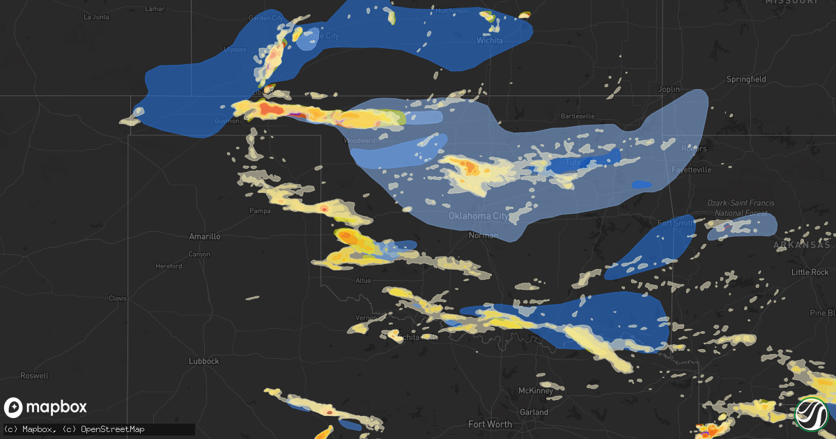
Hail Map in Oklahoma on June 17, 2023
Get this storm
June 17 map
$229
one time, instant access
Download today. No call, no setup
Keep the $229
Bought the map and want the full workflow? Apply the entire $229 to a subscription within 7 days. None of it is wasted.
Every map, not just this one
This buys you this map. Subscription and you get every map we run, in the markets you choose from a few cities to whole states to nationwide. Plus real-time alerts the moment a storm fires.
Contact data
Name, contact info, occupancy, even credit band for addresses in the footprint. You go from where it hit to who to call.
Become the source they trust
Unlimited branding weather history reports on demand. You already have the documented answer ready for the property owner, and you are the one who showed up with it.
Property data and RoofTrace estimates
Pull up any address you have got, its value and the exact code rules for that jurisdiction, straight from One Click Code. Then RoofTrace estimates the squares, pitch, and roof value, priced the way you price.
Storm reports in Oklahoma
Oklahoma
| Date | Description |
|---|---|
| 06/17/20236:53 PM CDT | A local report indicates 63 MPH wind near 1 WSW Guymon |
| 06/17/20236:53 PM CDT | D gst report from tulsa. Tulsa international airport. |
| 06/17/20236:50 PM CDT | A local report indicates 70 MPH wind near 1 W Hooker |
| 06/17/20236:25 PM CDT | A local report indicates 59 MPH wind near 12 NE Eva |
| 06/17/20236:22 PM CDT | Report submitted via spotter network. |
| 06/17/20236:20 PM CDT | Report submitted via spotter network. |
| 06/17/20236:03 PM CDT | Report submitted via spotter network. |
| 06/17/20236:01 PM CDT | Photo submitted via social media. Time estimated on radar. |
| 06/17/20235:57 PM CDT | Hail report submitted via spotter network. |
| 06/17/20235:54 PM CDT | Hail reported via spotter network. |
| 06/17/20235:45 PM CDT | Most hailstones were the size of nickels to quarters. However... There were some hailstones around 2 inches in diameter. |
| 06/17/20235:37 PM CDT | Quarter sized hail reported by storm chaser via social media 2 miles east of adams. |
| 06/17/20235:37 PM CDT | Picture submitted via social media. Time estimated on radar. |
| 06/17/20235:15 PM CDT | A local report indicates 59 MPH wind near 5 SE Kenton |
| 06/17/202312:40 PM CDT | Power flashes... Power outage.. Tree limbs down. |
| 06/17/202310:22 AM CDT | Facebook report. |
| 06/17/20231:55 AM CDT | A local report indicates 64 MPH wind near Grove |
| 06/17/20231:45 AM CDT | A few weak trees uprooted... A few homes with gutters ripped off... Many large branches down... Small branches and leaves everywhere. Relayed via twitter. |
| 06/17/20231:45 AM CDT | Large branches down didnt see any major tree damage power still on here no downed power lines winds were around 70-80 mph with leading edge of storm. |
| 06/17/20231:35 AM CDT | Several trees down. |
| 06/17/20231:21 AM CDT | A local report indicates 80 MPH wind near Chouteau |
| 06/17/20231:20 AM CDT | A local report indicates 74 MPH wind near 7 S Tahlequah |
| 06/17/20231:05 AM CDT | A local report indicates 70 MPH wind near Hulbert |
| 06/17/20231:05 AM CDT | Very large... Mature trees down... Two hackberry trees with trunk diameters of 1.5 ft + and root balls 6+ ft in diameter taken down by wind gusts. Mature hickory tree t |
| 06/17/20231:05 AM CDT | A local report indicates 75 MPH wind near Pryor |
| 06/17/20231:00 AM CDT | Roof blown off of commercial building; numerous large tree limbs down. |
| 06/17/20231:00 AM CDT | A local report indicates 60 MPH wind near Peggs |
| 06/17/20231:00 AM CDT | Numerous large tree limbs down; time estimated by radar. |
| 06/17/202312:58 AM CDT | Sveral large trees down; structural damage to a brick building. Time estimated from radar. |
| 06/17/202312:50 AM CDT | A local report indicates 65 MPH wind near Inola |
| 06/17/202312:50 AM CDT | Tulsa international airport. |
| 06/17/202312:50 AM CDT | Tree damage and part of wooden privacy fence destroyed. |
| 06/17/202312:45 AM CDT | Numerous tree limbs and power lines down from checotah to eufaula. |
| 06/17/202312:45 AM CDT | A 61 mph wind gust was recorded at oklahoma mesonet idabel site. |
| 06/17/202312:42 AM CDT | Tornado debris signature; time estimated by radar. |
| 06/17/202312:40 AM CDT | Extensive damage in and south of inola. Large trees snapped... Metal and wood/brick buildings collapsed. Power poles downed along approximately 3 mile stretch of 4200 r |
| 06/17/202312:40 AM CDT | An nws storm survey team has confirmed an ef1 tornado running from ssw of oologah to ese of oologah. Extensive tree and some structural damage was noted. Additional det |
| 06/17/202312:40 AM CDT | Corrects previous tstm wnd gst report from 1 e tulsa. Power flashes... Power outage.. Tree limbs down. |
| 06/17/202312:38 AM CDT | Large section of tree canopies/large branches snapped off near 106th st n and n 197th; time estimated by radar. |
| 06/17/202312:35 AM CDT | Report from mping: trees uprooted or snapped; roof blown off. |
| 06/17/202312:35 AM CDT | Multiple tree branches snapped around area up to 1ft in diameter. |
| 06/17/202312:35 AM CDT | A local report indicates 60 MPH wind near Sallisaw |
| 06/17/202312:32 AM CDT | *** 1 fatal * |
| 06/17/202312:32 AM CDT | *** 1 fatal *** a tree fell onto an rv at beavers bend state park... Resulting in a fatality of a female occupant inside. |
| 06/17/202312:30 AM CDT | Roofs blown off buildings at industrial park near 129th and admiral. |
| 06/17/202312:30 AM CDT | Corrects time of previous tstm wnd gst report from tulsa. Tulsa international airport. |
| 06/17/202312:30 AM CDT | Several tree limbs down. Winds estimated 70 mph. |
| 06/17/202312:27 AM CDT | Numerous trees and power lines were downed across much of mccurtain county. |
| 06/17/202312:27 AM CDT | Reported near 31st and peoria. |
| 06/17/202312:25 AM CDT | Tree limbs broken off. Garden and flowers laid flat to the south east ... Trash cans and debris in roads. |
| 06/17/202312:21 AM CDT | Trees down on old 98 from valliant to wright city. Trees also down on state highway 98 north of hwy 70. |
| 06/17/202312:20 AM CDT | Trees and power lines down near 41st and yale. |
| 06/17/202312:20 AM CDT | Several rvs at pine creek lake were flipped over by severe thunderstorm wind gusts. No injuries were reported. |
| 06/17/202312:15 AM CDT | Numerous 1-3 inch limbs down. |
| 06/17/202312:15 AM CDT | Tree down. Report relayed from public. |
| 06/17/202312:13 AM CDT | Jenks riverside airport. |
| 06/17/202312:09 AM CDT | A local report indicates 60 MPH wind near Oilton |
| 06/17/202312:06 AM CDT | Several large tree limbs |
| 06/17/202312:05 AM CDT | A local report indicates 90 MPH wind near 3 E Mannford |
| 06/17/202312:05 AM CDT | Roof damage to a home; several 15-24 inch diameter trees down; power lines down. Time estimated from radar. |
| 06/17/202312:05 AM CDT | Power lines down at 209th w ave and wekiwa rd. |
| 06/17/202312:05 AM CDT | Large tree down. |
| 06/17/202312:00 AM CDT | Polycarbonate roof on pergola torn loose. Large branches broken off trees. |
| 06/17/202312:00 AM CDT | Tree damage. |
| 06/16/202311:57 PM CDT | A local report indicates 59 MPH wind near Hugo |
| 06/16/202311:55 PM CDT | Measured at the oilton mesonet. |
| 06/16/202311:55 PM CDT | Street signs blown over... Large trees uprooted. |
| 06/16/202311:55 PM CDT | Large tree uprooted and down across road. |
| 06/16/202311:50 PM CDT | Measured by the oilton mesonet. |
| 06/16/202311:37 PM CDT | Structural damages throughout the town. |
| 06/16/202311:26 PM CDT | Tree limbs down... Car port tossed... Power line down. |
| 06/16/202311:26 PM CDT | A local report indicates 60 MPH wind near Cushing |
| 06/16/202311:25 PM CDT | A local report indicates 59 MPH wind near Tinker Air Force Base |
| 06/16/202311:23 PM CDT | Several homes with roof damage in indianola and crowder. |
| 06/16/202311:23 PM CDT | 6-8 inch tree limbs snapped. |
| 06/16/202311:22 PM CDT | Downed power lines. Time estimated. |
| 06/16/202311:21 PM CDT | A local report indicates 59 MPH wind near 3 NW Stillwater |
| 06/16/202311:20 PM CDT | A local report indicates 70 MPH wind near 2 NNW Perkins |
| 06/16/202311:17 PM CDT | 8-10 inch diameter tree limb down. |
| 06/16/202311:16 PM CDT | Numerous power lines down. Tree over roadway. |
| 06/16/202311:15 PM CDT | A local report indicates 61 MPH wind near 3 N Calera |
| 06/16/202311:15 PM CDT | A local report indicates 60 MPH wind near 3 NW Norman |
| 06/16/202311:15 PM CDT | Marena mesonet site. |
| 06/16/202311:15 PM CDT | A local report indicates 60 MPH wind near 2 NW Norman |
| 06/16/202311:15 PM CDT | A local report indicates 58 MPH wind near 2 NNW Perkins |
| 06/16/202311:14 PM CDT | Large tree down at parsons and flood. |
| 06/16/202311:13 PM CDT | Extensive tree damage. Numerous trees blocking city streets. |
| 06/16/202311:11 PM CDT | 4 in. Diameter tree limbs broken... Gutters and shingles damaged near 23rd and penn. |
| 06/16/202311:10 PM CDT | A local report indicates 60 MPH wind near 2 NW Del City |
| 06/16/202311:08 PM CDT | A local report indicates 63 MPH wind near 6 SW Oklahoma City |
| 06/16/202311:05 PM CDT | A local report indicates 58 MPH wind near 5 SSW Lake Carl Blackwe |
| 06/16/202311:04 PM CDT | Numerous power poles and trees limbs down. Time estimated. |
| 06/16/202311:01 PM CDT | Power lines down. |
| 06/16/202310:59 PM CDT | A local report indicates 58 MPH wind near 2 SSE Guthrie |
| 06/16/202310:59 PM CDT | A local report indicates 58 MPH wind near 2 S Guthrie |
| 06/16/202310:56 PM CDT | A local report indicates 59 MPH wind near 2 WNW Warr Acres |
| 06/16/202310:55 PM CDT | A local report indicates 69 MPH wind near 4 SSE Marshall |
| 06/16/202310:55 PM CDT | A local report indicates 59 MPH wind near 4 SE Piedmont |
| 06/16/202310:53 PM CDT | Several 3 inch tree limbs broken. |
| 06/16/202310:47 PM CDT | Numerous power lines down. Time estimated. |
| 06/16/202310:35 PM CDT | Mesonet station brec breckinridge. |
| 06/16/202310:34 PM CDT | Roof damaged. Near highway 1 and buffalo rd. Radar estimated time. |
| 06/16/202310:32 PM CDT | Tin roof removed from housing... Multiple trees uprooted and power lines down. |
| 06/16/202310:30 PM CDT | Mesonet station madi madill. |
| 06/16/202310:22 PM CDT | Corrects previous hail report from 6 wnw dempsey. Facebook report. |
| 06/16/202310:20 PM CDT | Tree down on state hwy 1 and cr 3510. Radar estimated time. |
| 06/16/202310:18 PM CDT | Awos station kend enid vance afb. |
| 06/16/202310:15 PM CDT | Awos station kjwg watonga. |
| 06/16/202310:12 PM CDT | Tree landed on a mobile home. Time estimated. |
| 06/16/202310:11 PM CDT | Semi turned over on i-35 mile marker 32. Time estimated. |
| 06/16/202310:10 PM CDT | Ardmore mesonet. |
| 06/16/202310:08 PM CDT | Damage to a warehouse... Tore off 39 air vents and causing extensive water damage. Time is radar estimate. |
| 06/16/20239:55 PM CDT | Mesonet station laho lahoma. |
| 06/16/20239:50 PM CDT | Mesonet station ring ringling. |
| 06/16/20239:35 PM CDT | Mesonet station cher cherokee. |
| 06/16/20239:26 PM CDT | A local report indicates 76 MPH wind near 1 S Cleo Springs |
| 06/16/20239:10 PM CDT | Mesonet station dw7732 alva. |
| 06/16/20239:00 PM CDT | Mesonet station seil seiling. |
| 06/16/20238:50 PM CDT | Mesonet station free freedom. |
| 06/16/20238:50 PM CDT | Social media video - damage to tree limbs. Time estimated. |
| 06/16/20238:25 PM CDT | Mesonet station wood woodward. |
| 06/16/20238:16 PM CDT | Em reports power line damage in vicinity of fort supply. Time estimated by radar. |
| 06/16/20238:15 PM CDT | Mesonet station buff buffalo. |
| 06/16/20238:06 PM CDT | Em reports power line damage in region of the arnett vicinity. Time estimated by radar. |
| 06/16/20238:02 PM CDT | Report from mping: 3-inch tree limbs broken; power poles broken. |
| 06/16/20237:50 PM CDT | Multiple sources including broadcast media... Ohp... And storm spotter. Time estimated from radar 7:50-7:55pm. |
| 06/16/20237:44 PM CDT | Report from mping: 3-inch tree limbs broken; power poles broken. Photo confirmed via twitter. |
| 06/16/20237:43 PM CDT | Report from mping: hen egg |
| 06/16/20237:35 PM CDT | A local report indicates 64 MPH wind near 8 W Slapout |
| 06/16/20237:32 PM CDT | Report submitted via spotter network. |
| 06/16/20237:05 PM CDT | A local report indicates 64 MPH wind near 1 SSW Beaver |
All States Impacted by Hail Map on June 17, 2023
Cities Impacted by Hail Map on June 17, 2023
- Grinnell, KS
- Hoxie, KS
- Weskan, KS
- Arapahoe, CO
- Sharon Springs, KS
- Wallace, KS
- Orlando, FL
- Malabar, FL
- Palm Bay, FL
- Laurel, MS
- Waynesboro, MS
- Pueblo, CO
- Beulah, CO
- Clayton, LA
- Ferriday, LA
- Vidalia, LA
- Richton, MS
- Newhebron, MS
- Castleberry, AL
- Repton, AL
- Brewton, AL
- Evergreen, AL
- Natchez, MS
- Colorado City, CO
- Rye, CO
- Avondale, CO
- Walsenburg, CO
- Fowler, CO
- Neely, MS
- Leakesville, MS
- Andalusia, AL
- Agate, CO
- Boone, CO
- Jay, FL
- Milton, FL
- Wing, AL
- Louin, MS
- Bay Springs, MS
- Lucedale, MS
- Stringer, MS
- Woodville, MS
- Baker, FL
- Marianna, FL
- Altha, FL
- Blountstown, FL
- Grand Ridge, FL
- Clyde, TX
- Abilene, TX
- Ovalo, TX
- Wilmer, AL
- Centreville, MS
- Holt, FL
- Eglin Afb, FL
- Baird, TX
- Bronte, TX
- Winters, TX
- Norton, TX
- Moss Point, MS
- Mobile, AL
- Grand Bay, AL
- Fort Walton Beach, FL
- Mary Esther, FL
- Hurlburt Field, FL
- Saint Francisville, LA
- Des Moines, NM
- Grenville, NM
- Jackson, LA
- Ethel, LA
- Kim, CO
- La Junta, CO
- Las Animas, CO
- Coden, AL
- Theodore, AL
- Irvington, AL
- Bayou La Batre, AL
- Folsom, NM
- Voss, TX
- Valera, TX
- Coleman, TX
- Gouldbusk, TX
- Santa Anna, TX
- Albany, TX
- Moran, TX
- State Line, MS
- Zachary, LA
- Slaughter, LA
- Baker, LA
- Erwinville, LA
- Baton Rouge, LA
- Talpa, TX
- Port Allen, LA
- Brusly, LA
- Cameron, MO
- Winston, MO
- Kidder, MO
- Hamilton, MO
- Lathrop, MO
- Lawson, MO
- Polo, MO
- Altamont, MO
- Gallatin, MO
- Hooker, OK
- Tyrone, OK
- Weatherby, MO
- Pattonsburg, MO
- Liberal, KS
- Waskom, TX
- Marshall, TX
- Karnack, TX
- McFall, MO
- San Angelo, TX
- Christoval, TX
- Kismet, KS
- Mount Olive, MS
- Manning, IA
- Manilla, IA
- Audubon, IA
- Pascagoula, MS
- Matheson, CO
- Limon, CO
- Nunn, CO
- Grover, CO
- Brooklet, GA
- Pembroke, GA
- Manzanola, CO
- Pritchett, CO
- Shubuta, MS
- Vossburg, MS
- Pachuta, MS
- Gilmore City, IA
- Palmer, IA
- Model, CO
- Byers, CO
- Waterproof, LA
- Strasburg, CO
- New Augusta, MS
- Beaumont, MS
- Rutland, IA
- Humboldt, IA
- Buckatunna, MS
- Raleigh, MS
- Harlan, IA
- Hugo, CO
- Karval, CO
- Havana, FL
- Tallahassee, FL
- Hogansville, GA
- Trinidad, CO
- Forest, MS
- Lake, MS
- Flagler, CO
- Olney Springs, CO
- Rocky Ford, CO
- Arriba, CO
- Vinegar Bend, AL
- Millry, AL
- Quincy, FL
- Wetmore, CO
- Loxahatchee, FL
- Wellington, FL
- Loxley, AL
- Robertsdale, AL
- Gretna, FL
- Chattahoochee, FL
- Opp, AL
- Elba, AL
- Wesson, MS
- Hazlehurst, MS
- Monticello, MS
- Norwood, LA
- Pulaski, MS
- Lena, MS
- Morton, MS
- Heidelberg, MS
- Anton, CO
- Silver Creek, MS
- Georgetown, MS
- Pinola, MS
- Monticello, FL
- Lloyd, FL
- McKenzie, AL
- Brantley, AL
- Dozier, AL
- Red Level, AL
- McLain, MS
- Springfield, CO
- Florence, CO
- Monroeville, AL
- Collins, MS
- Peterman, AL
- Citronelle, AL
- Rose Hill, MS
- Alford, FL
- Fountain, FL
- Chipley, FL
- Bristol, FL
- Greenville, FL
- Pahokee, FL
- Canal Point, FL
- Crestview, FL
- Shalimar, FL
- Live Oak, FL
- Ellisville, MS
- Semmes, AL
- Taylorsville, MS
- Soso, MS
- Paulding, MS
- Ovett, MS
- Quitman, MS
- Dawson, MN
- Petal, MS
- Merkel, TX
- Turpin, OK
- Tye, TX
- Dyess Afb, TX
- Beaver, OK
- Forgan, OK
- Rockwood, TX
- Mereta, TX
- Miles, TX
- Mooringsport, LA
- Shreveport, LA
- Rowena, TX
- Paint Rock, TX
- Ballinger, TX
- Burkett, TX
- Coffey, MO
- Bethany, MO
- Cross Plains, TX
- Brownwood, TX
- Rising Star, TX
- Rochelle, TX
- Brookesmith, TX
- Blanchard, LA
- Millersview, TX
- Borger, TX
- Pampa, TX
- Miami, TX
- Sublette, KS
- Satanta, KS
- Sanderson, FL
- Ridgeway, MO
- Campo, CO
- Boise City, OK
- Kenton, OK
- Felt, OK
- Rolla, KS
- Goodwell, OK
- Walsh, CO
- Elkhart, KS
- Keyes, OK
- Hugoton, KS
- Richfield, KS
- Texhoma, OK
- Snyder, TX
- Manter, KS
- Vilas, CO
- Johnson, KS
- Ulysses, KS
- Benton, LA
- Guymon, OK
- Jayton, TX
- Aspermont, TX
- Rotan, TX
- Stratford, TX
- Hamlin, TX
- Stamford, TX
- Rule, TX
- Trent, TX
- Plains, KS
- Copeland, KS
- Oil City, LA
- Jefferson, TX
- Vivian, LA
- Bossier City, LA
- Laverne, OK
- Moscow, KS
- Garden City, KS
- Lakin, KS
- Gruver, TX
- Texhoma, TX
- Gate, OK
- Anson, TX
- Holcomb, KS
- Montezuma, KS
- Canadian, TX
- Cimarron, KS
- Lohn, TX
- Plain Dealing, LA
- Ingalls, KS
- Meade, KS
- Pierceville, KS
- Casey, IA
- Hawley, TX
- Fontanelle, IA
- Greenfield, IA
- Menlo, IA
- Lueders, TX
- Avoca, TX
- Stuart, IA
- Cisco, TX
- Rosston, OK
- Fowler, KS
- Ensign, KS
- Doole, TX
- Vernon, TX
- Eden, TX
- Frederick, OK
- Loveland, OK
- Dodge City, KS
- Minneola, KS
- Jetmore, KS
- Brady, TX
- May, OK
- Carbon, TX
- Buffalo, OK
- Ford, KS
- Wright, KS
- Chattanooga, OK
- Indiahoma, OK
- Breckenridge, TX
- Haynesville, LA
- Emerson, AR
- Walters, OK
- Fort Supply, OK
- Freedom, OK
- Faxon, OK
- Cache, OK
- Spearville, KS
- Greensburg, KS
- Mullinville, KS
- Bucklin, KS
- Offerle, KS
- Junction City, AR
- Kinsley, KS
- Macksville, KS
- St John, KS
- Mooreland, OK
- Woodward, OK
- Alva, OK
- Burns, KS
- Electra, TX
- Iowa Park, TX
- Haviland, KS
- Lewis, KS
- Glen Saint Mary, FL
- Holliday, TX
- Waynoka, OK
- Cassoday, KS
- Chester, OK
- Dacoma, OK
- Aline, OK
- Carmen, OK
- Wichita Falls, TX
- Fairview, OK
- Seiling, OK
- Cleo Springs, OK
- Ryan, OK
- Waurika, OK
- Burlington, OK
- Cherokee, OK
- Orient, IA
- Helena, OK
- Amorita, OK
- Manchester, OK
- Winterset, IA
- Fargo, OK
- Sharon, OK
- Mutual, OK
- Vici, OK
- Fay, OK
- Taloga, OK
- Custer City, OK
- Thomas, OK
- Weatherford, OK
- Putnam, OK
- Oakwood, OK
- Okarche, OK
- Longdale, OK
- Isabella, OK
- Meno, OK
- Southard, OK
- Calumet, OK
- Geary, OK
- Canton, OK
- Ringwood, OK
- Goltry, OK
- Ames, OK
- Greenfield, OK
- Kingfisher, OK
- Jet, OK
- Hitchcock, OK
- Watonga, OK
- Hennessey, OK
- Omega, OK
- Okeene, OK
- Hinton, OK
- Hydro, OK
- Valley Center, KS
- Wichita, KS
- Arnett, OK
- Camargo, OK
- Nash, OK
- Lahoma, OK
- Waukomis, OK
- Kremlin, OK
- Enid, OK
- Drummond, OK
- Carrier, OK
- Pond Creek, OK
- Medford, OK
- Wakita, OK
- Dover, OK
- Marshall, OK
- Loyal, OK
- Hunter, OK
- Douglas, OK
- Fairmont, OK
- Bison, OK
- Thayer, IA
- Afton, IA
- Murray, IA
- Mobeetie, TX
- Eureka, KS
- Hamilton, KS
- Newton, KS
- Halstead, KS
- Creston, IA
- Wheeler, TX
- Briscoe, TX
- Lenox, IA
- Bedford, IA
- Clearfield, IA
- Early, TX
- Zephyr, TX
- Mullin, TX
- Ringling, OK
- Wilson, OK
- Healdton, OK
- Lone Grove, OK
- Ardmore, OK
- Springer, OK
- Loco, OK
- Sedgwick, KS
- Garber, OK
- Tonkawa, OK
- Deer Creek, OK
- Crescent, OK
- Nardin, OK
- Billings, OK
- Lamont, OK
- Covington, OK
- Braman, OK
- Blackwell, OK
- Binger, OK
- El Reno, OK
- Lookeba, OK
- Larned, KS
- Garfield, KS
- Hanston, KS
- Rozel, KS
- Burdett, KS
- Tishomingo, OK
- Madill, OK
- Mannsville, OK
- Mill Creek, OK
- Belpre, KS
- Great Bend, KS
- Pawnee Rock, KS
- Otis, KS
- Rush Center, KS
- Albert, KS
- Hoisington, KS
- Olmitz, KS
- Bison, KS
- Claflin, KS
- Russell, KS
- Bunker Hill, KS
- Dorrance, KS
- Pratt, KS
- Cunningham, KS
- Byers, KS
- Iuka, KS
- Stafford, KS
- Turon, KS
- Hudson, KS
- Sylvia, KS
- Plevna, KS
- Murdock, KS
- Abbyville, KS
- South Hutchinson, KS
- Haven, KS
- Pretty Prairie, KS
- Kingman, KS
- Partridge, KS
- Arlington, KS
- Cheney, KS
- Nickerson, KS
- Hutchinson, KS
- Buhler, KS
- Sweetwater, OK
- Reydon, OK
- Cheyenne, OK
- Goldthwaite, TX
- Sayre, OK
- Goddard, KS
- Burrton, KS
- Andale, KS
- Colwich, KS
- Bentley, KS
- Garden Plain, KS
- Mount Hope, KS
- Norwich, KS
- Nashville, KS
- Spivey, KS
- Isabel, KS
- Milton, KS
- Viola, KS
- Harper, KS
- Zenda, KS
- Clearwater, KS
- Argonia, KS
- Danville, KS
- Conway Springs, KS
- Sawyer, KS
- Oklahoma City, OK
- Yukon, OK
- Minco, OK
- Union City, OK
- Mustang, OK
- Cashion, OK
- Piedmont, OK
- Mulhall, OK
- Guthrie, OK
- Perry, OK
- Lucien, OK
- Bethany, OK
- Orlando, OK
- Edmond, OK
- Wheatland, OK
- Blanchard, OK
- Tuttle, OK
- Newcastle, OK
- Erick, OK
- Carter, OK
- Willow, OK
- Granite, OK
- Norman, OK
- Coyle, OK
- Jones, OK
- Spencer, OK
- Meridian, OK
- Perkins, OK
- Ponca City, OK
- Morrison, OK
- Harrah, OK
- Arcadia, OK
- Choctaw, OK
- Wellston, OK
- Stillwater, OK
- Carney, OK
- Red Rock, OK
- Luther, OK
- Marland, OK
- Whitewater, KS
- Jefferson, IA
- Vona, CO
- Stratton, CO
- Kit Carson, CO
- Sweetwater, TX
- Maysville, MO
- Dana, IA
- Ogden, IA
- Grand Junction, IA
- Otis, CO
- Crowell, TX
- Ozona, TX
- Cope, CO
- Fulda, MN
- Redfield, IA
- Adair, IA
- Lane, OK
- Stringtown, OK
- Winona, KS
- Cheyenne Wells, CO
- Bangs, TX
- Sharpsburg, IA
- Diagonal, IA
- Gravity, IA
- Rippey, IA
- Pine Hill, AL
- Vredenburgh, AL
- Lower Peach Tree, AL
- Coy, AL
- Gonzales, LA
- Prairieville, LA
- Statesboro, GA
- Lewis, IA
- Atlantic, IA
- Mertzon, TX
- Harrold, TX
- Oklaunion, TX
- Braymer, MO
- Cowgill, MO
- Belcher, LA
- Remsen, IA
- Marcus, IA
- Cotton Valley, LA
- Badger, IA
- Clare, IA
- Fort Dodge, IA
- Jackson, AL
- Englewood, KS
- Bainbridge, GA
- Brinson, GA
- Iron City, GA
- Mize, MS
- Grandfield, OK
- Kingsley, IA
- Lake City, FL
- Lake Butler, FL
- May, TX
- Davidson, OK
- Wiggins, MS
- Blanket, TX
- Ellabell, GA
- Perryton, TX
- Spearman, TX
- Balko, OK
- Destin, FL
- Ashland, KS
- Eola, TX
- Akron, CO
- Palatka, FL
- Gautier, MS
- Clayton, NM
- Coffeeville, AL
- Sarepta, LA
- Crosby, MS
- Roscoe, TX
- Potwin, KS
- El Dorado, KS
- Hardesty, OK
- Lutz, FL
- Tampa, FL
- Land O'Lakes, FL
- New Port Richey, FL
- Odessa, FL
- Port Richey, FL
- Randlett, OK
- Temple, OK
- Byers, TX
- Petrolia, TX
- Seminary, MS
- Panora, IA
- Guthrie Center, IA
- Sorrento, LA
- Climax, GA
- Thomasville, GA
- Cairo, GA
- Fort Lauderdale, FL
- Shongaloo, LA
- Lillie, LA
- Fort White, FL
- Wellborn, FL
- Waldron, KS
- Comanche, OK
- Spearsville, LA
- Duncan, OK
- Brooklyn, MS
- Jonesville, LA
- Roxie, MS
- Quitaque, TX
- Nolan, TX
- Bonaire, GA
- Comanche, TX
- Sidney, TX
- Bluff City, KS
- Devol, OK
- Hastings, OK
- Miami, FL
- Hallandale, FL
- Hollywood, FL
- North Miami Beach, FL
- Anthony, KS
- Attica, KS
- Westboro, MO
- Elmo, MO
- Franklin, AL
- Lincoln, AL
- Sterling, KS
- Wall, TX
- Sentinel, OK
- Lone Wolf, OK
- Newalla, OK
- Mcloud, OK
- Noble, OK
- Glencoe, OK
- Ripley, OK
- Agra, OK
- Chandler, OK
- Tryon, OK
- Wellington, KS
- Haysville, KS
- Peck, KS
- Mulvane, KS
- Derby, KS
- Maize, KS
- Mcconnell Afb, KS
- Canton, KS
- Moundridge, KS
- Hesston, KS
- Mead, OK
- Cartwright, OK
- Kingston, OK
- Colbert, OK
- Calera, OK
- Kenefic, OK
- Bokchito, OK
- Caddo, OK
- Milburn, OK
- Durant, OK
- Ravenna, TX
- Hendrix, OK
- Caney, OK
- Finley, OK
- Coleman, OK
- Antlers, OK
- Moyers, OK
- Bennington, OK
- Atoka, OK
- Boswell, OK
- Clayton, OK
- Snow, OK
- Wapanucka, OK
- Macomb, OK
- Wanette, OK
- Shawnee, OK
- Tecumseh, OK
- Lexington, OK
- Yale, OK
- Pawnee, OK
- Jennings, OK
- Drumright, OK
- Cushing, OK
- Maramec, OK
- Meeker, OK
- Stroud, OK
- Davenport, OK
- Sparks, OK
- Gotebo, OK
- Hobart, OK
- Roosevelt, OK
- Cordell, OK
- Mountain View, OK
- Rocky, OK
- Carnegie, OK
- Rose Hill, KS
- North Newton, KS
- Kechi, KS
- Greenwich, KS
- Benton, KS
- Augusta, KS
- Andover, KS
- Towanda, KS
- Leon, KS
- Prue, OK
- Mannford, OK
- Osage, OK
- Cleveland, OK
- Terlton, OK
- Bristow, OK
- Depew, OK
- Sand Springs, OK
- Fairfax, OK
- Barnsdall, OK
- Skiatook, OK
- Hominy, OK
- Wynona, OK
- Ralston, OK
- Earlsboro, OK
- Kellyville, OK
- Prague, OK
- Castle, OK
- Paden, OK
- Okemah, OK
- Boley, OK
- Seminole, OK
- Sapulpa, OK
- Fort Cobb, OK
- Beggs, OK
- Mounds, OK
- Okmulgee, OK
- Pawhuska, OK
- Telephone, TX
- Sumner, TX
- Rattan, OK
- Grant, OK
- Hugo, OK
- Soper, OK
- Arthur City, TX
- Ivanhoe, TX
- Paris, TX
- Honey Grove, TX
- Powderly, TX
- Mangum, OK
- Wister, OK
- Mccurtain, OK
- Red Oak, OK
- Talihina, OK
- Wilburton, OK
- Tuskahoma, OK
- Poteau, OK
- Howe, OK
- Heavener, OK
- Hodgen, OK
- Waldron, AR
- Hartford, AR
- Bokoshe, OK
- Shady Point, OK
- Keota, OK
- Henryetta, OK
- Kiefer, OK
- Weleetka, OK
- Morris, OK
- Bixby, OK
- Ramona, OK
- Sperry, OK
- Vera, OK
- Collinsville, OK
- Glenpool, OK
- Bartlesville, OK
- Tulsa, OK
- Owasso, OK
- Broken Arrow, OK
- Jenks, OK
- Ochelata, OK
- Rosalia, KS
- Cameron, OK
- Mansfield, AR
- Booneville, AR
- Hackett, AR
- Dill City, OK
- Elk City, OK
- Council Hill, OK
- Haskell, OK
- Catoosa, OK
- Claremore, OK
- Boynton, OK
- Talala, OK
- Oologah, OK
- Coweta, OK
- Pocola, OK
- Midland, AR
- Muldrow, OK
- Spiro, OK
- Huntington, AR
- Inola, OK
- Wagoner, OK
- Chouteau, OK
- Redbird, OK
- Pryor, OK
- Porter, OK
- Chelsea, OK
- Nowata, OK
- Taft, OK
- Oktaha, OK
- Muskogee, OK
- Checotah, OK
- Bagwell, TX
- Bethel, OK
- Rufe, OK
- Detroit, TX
- Idabel, OK
- Broken Bow, OK
- Fort Towson, OK
- Blossom, TX
- Eagletown, OK
- Wright City, OK
- Garvin, OK
- Sawyer, OK
- Ringold, OK
- Clarksville, TX
- Spencerville, OK
- Valliant, OK
- Haworth, OK
- Nashoba, OK
- Charleston, AR
- Fort Smith, AR
- Greenwood, AR
- Barling, AR
- Arkoma, OK
- Lavaca, AR
- Roland, OK
- Van Buren, AR
- Big Cabin, OK
- Fort Gibson, OK
- Adair, OK
- Alma, AR
- Locust Grove, OK
- Hulbert, OK
- Tahlequah, OK
- Peggs, OK
- Braggs, OK
- Salina, OK
- Vinita, OK
- Avery, TX
- De Kalb, TX
- Watson, OK
- Hatfield, AR
- Smithville, OK
- Vandervoort, AR
- Porum, OK
- Cove, AR
- Webbers Falls, OK
- Warner, OK
- Stigler, OK
- Rose, OK
- Strang, OK
- Proctor, OK
- Spavinaw, OK
- Paris, AR
- Subiaco, AR
- Scranton, AR
- Welling, OK
- Park Hill, OK
- Bunch, OK
- Stilwell, OK
- Magazine, AR
- Delaware, AR
- Dardanelle, AR
- New Blaine, AR
- Dover, AR
- Lamar, AR
- Knoxville, AR
- Russellville, AR
- London, AR
- Pottsville, AR
- Afton, OK
- Ketchum, OK
- Noel, MO
- Siloam Springs, AR
- Wyandotte, OK
- Grove, OK
- Maysville, AR
- Watts, OK
- Fayetteville, AR
- Twin Oaks, OK
- Anderson, MO
- Lincoln, AR
- Gravette, AR
- Kansas, OK
- Gentry, AR
- Summers, AR
- South West City, MO
- Oaks, OK
- Prairie Grove, AR
- Westville, OK
- Bentonville, AR
- Colcord, OK
- Jay, OK
- Sulphur Springs, AR
- Decatur, AR
- Eucha, OK
- Tiff City, MO
- Fairland, OK
- Pelsor, AR
- Jerusalem, AR
- Hattieville, AR
- Atkins, AR
- Hector, AR
- Cainsville, MO
- Inman, KS
- Mcpherson, KS
- Shannon City, IA
- Ellston, IA
- Pittsburg, OK
- Springfield, AR
- Higgins, TX
- Okolona, AR
- Prescott, AR
- Ozan, AR
- Gurdon, AR
- Blevins, AR
- Lockesburg, AR
- De Queen, AR
- Hampton, AR
- Washington, AR
- Hope, AR
- Galena, MO
- Cape Fair, MO
- Canute, OK
- Caldwell, KS
- Blanco, OK
- Winfield, KS
- Malvern, AR
- Sims, AR
- Pencil Bluff, AR
- Amity, AR
- Delight, AR
- Murfreesboro, AR
- Gould, OK
- Durham, OK
- Fulton, AR
- Greenbrier, AR
- Conway, AR
- Liberty, KS
- Coffeyville, KS
- Rush Springs, OK
- Ninnekah, OK
- Warren, AR
- Hermitage, AR
- Cyril, OK
- Emmet, AR
- Columbus, AR
- Mineral Springs, AR
- McCaskill, AR
- Nashville, AR
- Bonnerdale, AR
- Houston, AR
- Bigelow, AR
- Perryville, AR
- Perry, AR
- S Coffeyville, OK
- Nocona, TX
- Apache, OK
- Burneyville, OK
- Story, AR
- Mena, AR
- Norman, AR
- Donaldson, AR
- Huntsville, AR
- Foss, OK
- Stinnett, TX
- Butler, OK
- Hammon, OK
- Vinson, OK
- Camden, AR
- Chidester, AR
- Ozark, AR
- Ratcliff, AR
- Hot Springs National Park, AR
- Jessieville, AR
- Madrid, IA
- Kelley, IA
- Slater, IA
- Rogers, AR
- Bradley, OK
- Cecil, AR
- Lorimor, IA
- Lindsay, OK
- Cement, OK
- Fletcher, OK
- Ashdown, AR
- Coalgate, OK
- Solgohachia, AR
- Dexter, IA
- Earlham, IA
- Traskwood, AR
- Mount Ida, AR
- Oden, AR
- Damascus, AR
- Mount Vernon, AR
- Elgin, OK
- Bearden, AR
- Missouri Valley, IA
- Arkadelphia, AR
- Olustee, OK
- Elmer, OK
- South Haven, KS
- Morrilton, AR
- Plumerville, AR
- Tipton, OK
- Jersey, AR
- Banks, AR
- Bismarck, AR
- Pearcy, AR
- Lindsborg, KS
- Harrell, AR
- Leedey, OK
- Chickasha, OK
- Anadarko, OK
- Hollis, OK
- Wellington, TX
- El Dorado, AR
- Quitman, AR
- Rose Bud, AR
- Sulphur, OK
- Centrahoma, OK
- Guyton, GA
- Bloomingdale, GA
- Hartman, AR
- Altus, AR
- Branch, AR
- Coal Hill, AR
- Hartshorne, OK
- Farmington, AR
- Springdale, AR
- Powell, MO
- Seneca, MO
- Goodman, MO
- Stark City, MO
- Fairview, MO
- Pineville, MO
- Pierce City, MO
- Diamond, MO
- Lanagan, MO
- Granby, MO
- Neosho, MO
- Wentworth, MO
- Cave Springs, AR
- Sarcoxie, MO
- Rocky Comfort, MO
- Stella, MO
- Bella Vista, AR
- Centerton, AR
- Hiwasse, AR
- Exeter, MO
- Purdy, MO
- Pea Ridge, AR
- Washburn, MO
- Wheaton, MO
- Seligman, MO
- Garfield, AR
- Lowell, AR
- Monett, MO
- Cassville, MO
- Butterfield, MO
- Bogata, TX
- Deport, TX
- Cookville, TX
- Mount Pleasant, TX
- Montrose, AR
- Crossett, AR
- Hamburg, AR
- Fountain Hill, AR
- Bastrop, LA
- Mer Rouge, LA
- Bonita, LA
- Parkdale, AR
- Portland, AR
- Jones, LA
- Wilmot, AR
- Marietta, OK
- Overbrook, OK
- Brookston, TX
- Vicksburg, MS
- Edwards, MS
- Raymond, MS
- Utica, MS
- Crystal Springs, MS
- Terry, MS
- Stuart, OK
- Kiowa, OK
- Omaha, TX
- Searcy, AR
- Romance, AR
- Aurora, MO
- Roff, OK
- Vilonia, AR
- El Paso, AR
- Foster, OK
- Greenville, TX
- Nevada, TX
- Farmersville, TX
- Caddo Mills, TX
- Tingley, IA
- Osceola, IA
- Summerfield, LA
- Pickens, MS
- Camden, MS
- Bernice, LA
- Henrietta, TX
- Farmerville, LA
- Van Alstyne, TX
- Anna, TX
- Monroe, LA
- Sumrall, MS
- Elmore City, OK
- Alex, OK
- Saint Jo, TX
- Pioneer, LA
- Lake Providence, LA
- Erie, KS
- Stonewall, OK
- Carrollton, MS
- Atlanta, TX
- Homer, LA
- Lisbon, LA
- Foreman, AR
- Walnut Ridge, AR
- Greenwood, MS
- Hernando, MS
- Douglassville, TX
- Prentiss, MS
- Pattonville, TX
- Valley Park, MS
- Mayersville, MS
- Cary, MS
- Rolling Fork, MS
- Yazoo City, MS
- Honobia, OK
- Dubach, LA
- Horatio, AR
- Winthrop, AR
- Taylor, AR
- Springhill, LA
- Rayville, LA
- Oak Ridge, LA
- Enola, AR
- Eudora, AR
- Princeton, TX
- Mckinney, TX
- Blue Ridge, TX
- Melissa, TX
- Alleene, AR
- Nesbit, MS
- Bono, AR
- Oswego, KS
- Strong, AR
- Huttig, AR
- Hot Springs Village, AR
- Marion, LA
- Sulphur Springs, TX
- Cumby, TX
- Mound Valley, KS
- Delhi, LA
- Celeste, TX
- Magnolia, AR
- Altamont, KS
- Edna, KS
- Bartlett, KS
- Beebe, AR
- Texarkana, AR
- Texarkana, TX
- Verona, MO
- Oak Grove, LA
- Sheppard Afb, TX
- Bradley, AR
- Lewisville, AR
- Blair, OK
- Pauls Valley, OK
- Maysville, OK
- Rodessa, LA
- Doddridge, AR
- Ida, LA
- Collinston, LA
- Sterlington, LA
- Wilmar, AR
- Carthage, MS
- Simms, TX
- Talco, TX
- Tupelo, OK
- Royse City, TX
- Welch, OK
- Haughton, LA
- Helena, AR
- West Helena, AR
- Fouke, AR
- Mountain View, MO
- Marlow, OK
- Maud, TX
- New Boston, TX
- Hooks, TX
- Fitzhugh, OK
- McRae, AR
- Whitewright, TX
- Hoxie, AR
- Walnut Grove, MS
- Port Gibson, MS
- Hermanville, MS
- Newellton, LA
- Bolton, MS
- Redwood, MS
- Harrisville, MS
- De Kalb, MS
- Collinsville, MS
- Conehatta, MS
- Decatur, MS
- Union, MS
- Satartia, MS
- Bentonia, MS
- Tallulah, LA
- Grenada, MS
- Kosciusko, MS
- Scooba, MS
- Louisville, MS
- Noxapater, MS
- Braxton, MS
- Winnsboro, LA
- Preston, MS
- Shuqualak, MS
- Roxton, TX
- Baskin, LA
- Lake Cormorant, MS


