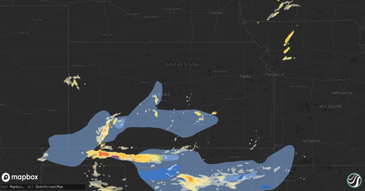
Hail Map in Kansas on June 17, 2023
Get this storm
June 17 map
$229
one time, instant access
Download today. No call, no setup
Keep the $229
Bought the map and want the full workflow? Apply the entire $229 to a subscription within 7 days. None of it is wasted.
Every map, not just this one
This buys you this map. Subscription and you get every map we run, in the markets you choose from a few cities to whole states to nationwide. Plus real-time alerts the moment a storm fires.
Contact data
Name, contact info, occupancy, even credit band for addresses in the footprint. You go from where it hit to who to call.
Become the source they trust
Unlimited branding weather history reports on demand. You already have the documented answer ready for the property owner, and you are the one who showed up with it.
Property data and RoofTrace estimates
Pull up any address you have got, its value and the exact code rules for that jurisdiction, straight from One Click Code. Then RoofTrace estimates the squares, pitch, and roof value, priced the way you price.
Storm reports in Kansas
Kansas
| Date | Description |
|---|---|
| 06/17/20236:59 PM CDT | A local report indicates 1.75 inch wind near 1 E Tice |
| 06/17/20236:54 PM CDT | 3.25 inches. |
| 06/17/20236:54 PM CDT | 3.25 inches. |
| 06/17/20236:50 PM CDT | A local report indicates 60 MPH wind near Lakin |
| 06/17/20236:23 PM CDT | Mesonet station cglk1 cimarron. |
| 06/17/20236:11 PM CDT | Mesonet station cw8810 elkhart. |
| 06/17/20232:25 AM CDT | A large limb was broken out of a tree. |
| 06/16/202311:30 PM CDT | Powerlines down and large tree limbs down in road way of the 6100 block of e douglas ave. |
| 06/16/202311:15 PM CDT | A local report indicates 62 MPH wind near 3 ESE Bel Aire |
| 06/16/202311:01 PM CDT | Report came in through social media of a 3 inch tree that was down at the base. |
| 06/16/202310:56 PM CDT | A local report indicates 71 MPH wind near 1 SE Wichita Eisenhower |
| 06/16/202310:51 PM CDT | A local report indicates 60 MPH wind near 1 SSE Wichita Eisenhowe |
| 06/16/202310:48 PM CDT | A local report indicates 62 MPH wind near 1 N Conway Springs |
| 06/16/202310:40 PM CDT | A local report indicates 62 MPH wind near 5 SSE Goddard |
| 06/16/202310:35 PM CDT | A local report indicates 65 MPH wind near 5 ESE Norwich |
| 06/16/202310:33 PM CDT | A local report indicates 66 MPH wind near 3 E Hutchinson |
| 06/16/202310:32 PM CDT | A local report indicates 62 MPH wind near Hutchinson Airport |
| 06/16/202310:20 PM CDT | A local report indicates 70 MPH wind near Russell Airport |
| 06/16/202310:20 PM CDT | Quarter inch hail covering the ground. |
| 06/16/202310:04 PM CDT | A local report indicates 70 MPH wind near Kingman |
| 06/16/20239:56 PM CDT | Multiple tree limbs down. Delayed report. Time estimated from radar. |
| 06/16/20239:54 PM CDT | Also reported some large tree limbs down in town. |
| 06/16/20239:37 PM CDT | Public sent in a video of wind and hail falling. Wind speeds were estimated to be 65 mph. |
| 06/16/20239:37 PM CDT | Reported through social media. |
| 06/16/20239:15 PM CDT | Spotter reported multiple power lines down along sr34 road. |
| 06/16/20238:55 PM CDT | Several 6 - 8 inch tree limbs down in city park. |
| 06/16/20238:52 PM CDT | Asos station kddc dodge city regional airport. |
| 06/16/20238:48 PM CDT | A local report indicates 1.00 inch wind near Park City |
| 06/16/20238:30 PM CDT | Mesonet station kjtk1. |
| 06/16/20238:20 PM CDT | Tree down... Reported through social media. |
| 06/16/20238:15 PM CDT | A local report indicates 63 MPH wind near 3 NW Ft. Dodge |
| 06/16/20238:15 PM CDT | Tree limbs down on north side of town. Reported through social media. |
| 06/16/20238:15 PM CDT | Mesonet station cw9785 dodge city. |
| 06/16/20238:10 PM CDT | Tree down... Photo. Reported through social media. |
| 06/16/20238:10 PM CDT | Tree down... Photo. Reported through social media. |
| 06/16/20238:07 PM CDT | Several poles down near roads h and i and highway 56. Also winds estimated at 70 mph. |
| 06/16/20238:00 PM CDT | Mesonet station up313 2.1 w minneola |
| 06/16/20237:55 PM CDT | Mesonet station fw8871 cimarron. |
| 06/16/20237:54 PM CDT | Asos station kgck garden city. |
| 06/16/20237:42 PM CDT | Public report through mping 1 inch tree limbs broken and shingles blown off. |
| 06/16/20237:38 PM CDT | Reported through social media. |
| 06/16/20237:36 PM CDT | Reported through social media. |
| 06/16/20237:30 PM CDT | 3 pivot sprinklers blown over and 13 power poles blown down. Power lost. Report was from social media with picture of power poles blown down. Time estimated from radar. |
| 06/16/20237:17 PM CDT | Corrects time of event from previous tstm wnd dmg report from 3 nnw tice. 3 pivot sprinklers blown over and 13 power poles blown down. Power lost. Report was from socia |
| 06/16/20237:16 PM CDT | Reported as 65 to 70 mph wind. Reported through social media. |
| 06/16/20237:16 PM CDT | A local report indicates 70 MPH wind near Sublette |
| 06/16/20237:15 PM CDT | Awos station k19s 1 ne sublette. |
| 06/16/20237:15 PM CDT | Reported through social media. |
| 06/16/20237:15 PM CDT | Numerous structural damage to utility poles and a gas station awning. Photos sent though social media. |
| 06/16/20237:14 PM CDT | Mesonet station up407 0.6 sw hayne |
| 06/16/20237:12 PM CDT | Mesonet station ur350 4.4 ne hayne |
| 06/16/20237:10 PM CDT | Mesonet station sauk1. |
| 06/16/20237:02 PM CDT | At least two flipped semis and power poles down in liberal. |
| 06/16/20237:00 PM CDT | Report was from social media with a picture. |
| 06/16/20237:00 PM CDT | A local report indicates 2.75 inch wind near Liberal |
All States Impacted by Hail Map on June 17, 2023
Cities Impacted by Hail Map on June 17, 2023
- Grinnell, KS
- Hoxie, KS
- Weskan, KS
- Arapahoe, CO
- Sharon Springs, KS
- Wallace, KS
- Orlando, FL
- Malabar, FL
- Palm Bay, FL
- Laurel, MS
- Waynesboro, MS
- Pueblo, CO
- Beulah, CO
- Clayton, LA
- Ferriday, LA
- Vidalia, LA
- Richton, MS
- Newhebron, MS
- Castleberry, AL
- Repton, AL
- Brewton, AL
- Evergreen, AL
- Natchez, MS
- Colorado City, CO
- Rye, CO
- Avondale, CO
- Walsenburg, CO
- Fowler, CO
- Neely, MS
- Leakesville, MS
- Andalusia, AL
- Agate, CO
- Boone, CO
- Jay, FL
- Milton, FL
- Wing, AL
- Louin, MS
- Bay Springs, MS
- Lucedale, MS
- Stringer, MS
- Woodville, MS
- Baker, FL
- Marianna, FL
- Altha, FL
- Blountstown, FL
- Grand Ridge, FL
- Clyde, TX
- Abilene, TX
- Ovalo, TX
- Wilmer, AL
- Centreville, MS
- Holt, FL
- Eglin Afb, FL
- Baird, TX
- Bronte, TX
- Winters, TX
- Norton, TX
- Moss Point, MS
- Mobile, AL
- Grand Bay, AL
- Fort Walton Beach, FL
- Mary Esther, FL
- Hurlburt Field, FL
- Saint Francisville, LA
- Des Moines, NM
- Grenville, NM
- Jackson, LA
- Ethel, LA
- Kim, CO
- La Junta, CO
- Las Animas, CO
- Coden, AL
- Theodore, AL
- Irvington, AL
- Bayou La Batre, AL
- Folsom, NM
- Voss, TX
- Valera, TX
- Coleman, TX
- Gouldbusk, TX
- Santa Anna, TX
- Albany, TX
- Moran, TX
- State Line, MS
- Zachary, LA
- Slaughter, LA
- Baker, LA
- Erwinville, LA
- Baton Rouge, LA
- Talpa, TX
- Port Allen, LA
- Brusly, LA
- Cameron, MO
- Winston, MO
- Kidder, MO
- Hamilton, MO
- Lathrop, MO
- Lawson, MO
- Polo, MO
- Altamont, MO
- Gallatin, MO
- Hooker, OK
- Tyrone, OK
- Weatherby, MO
- Pattonsburg, MO
- Liberal, KS
- Waskom, TX
- Marshall, TX
- Karnack, TX
- McFall, MO
- San Angelo, TX
- Christoval, TX
- Kismet, KS
- Mount Olive, MS
- Manning, IA
- Manilla, IA
- Audubon, IA
- Pascagoula, MS
- Matheson, CO
- Limon, CO
- Nunn, CO
- Grover, CO
- Brooklet, GA
- Pembroke, GA
- Manzanola, CO
- Pritchett, CO
- Shubuta, MS
- Vossburg, MS
- Pachuta, MS
- Gilmore City, IA
- Palmer, IA
- Model, CO
- Byers, CO
- Waterproof, LA
- Strasburg, CO
- New Augusta, MS
- Beaumont, MS
- Rutland, IA
- Humboldt, IA
- Buckatunna, MS
- Raleigh, MS
- Harlan, IA
- Hugo, CO
- Karval, CO
- Havana, FL
- Tallahassee, FL
- Hogansville, GA
- Trinidad, CO
- Forest, MS
- Lake, MS
- Flagler, CO
- Olney Springs, CO
- Rocky Ford, CO
- Arriba, CO
- Vinegar Bend, AL
- Millry, AL
- Quincy, FL
- Wetmore, CO
- Loxahatchee, FL
- Wellington, FL
- Loxley, AL
- Robertsdale, AL
- Gretna, FL
- Chattahoochee, FL
- Opp, AL
- Elba, AL
- Wesson, MS
- Hazlehurst, MS
- Monticello, MS
- Norwood, LA
- Pulaski, MS
- Lena, MS
- Morton, MS
- Heidelberg, MS
- Anton, CO
- Silver Creek, MS
- Georgetown, MS
- Pinola, MS
- Monticello, FL
- Lloyd, FL
- McKenzie, AL
- Brantley, AL
- Dozier, AL
- Red Level, AL
- McLain, MS
- Springfield, CO
- Florence, CO
- Monroeville, AL
- Collins, MS
- Peterman, AL
- Citronelle, AL
- Rose Hill, MS
- Alford, FL
- Fountain, FL
- Chipley, FL
- Bristol, FL
- Greenville, FL
- Pahokee, FL
- Canal Point, FL
- Crestview, FL
- Shalimar, FL
- Live Oak, FL
- Ellisville, MS
- Semmes, AL
- Taylorsville, MS
- Soso, MS
- Paulding, MS
- Ovett, MS
- Quitman, MS
- Dawson, MN
- Petal, MS
- Merkel, TX
- Turpin, OK
- Tye, TX
- Dyess Afb, TX
- Beaver, OK
- Forgan, OK
- Rockwood, TX
- Mereta, TX
- Miles, TX
- Mooringsport, LA
- Shreveport, LA
- Rowena, TX
- Paint Rock, TX
- Ballinger, TX
- Burkett, TX
- Coffey, MO
- Bethany, MO
- Cross Plains, TX
- Brownwood, TX
- Rising Star, TX
- Rochelle, TX
- Brookesmith, TX
- Blanchard, LA
- Millersview, TX
- Borger, TX
- Pampa, TX
- Miami, TX
- Sublette, KS
- Satanta, KS
- Sanderson, FL
- Ridgeway, MO
- Campo, CO
- Boise City, OK
- Kenton, OK
- Felt, OK
- Rolla, KS
- Goodwell, OK
- Walsh, CO
- Elkhart, KS
- Keyes, OK
- Hugoton, KS
- Richfield, KS
- Texhoma, OK
- Snyder, TX
- Manter, KS
- Vilas, CO
- Johnson, KS
- Ulysses, KS
- Benton, LA
- Guymon, OK
- Jayton, TX
- Aspermont, TX
- Rotan, TX
- Stratford, TX
- Hamlin, TX
- Stamford, TX
- Rule, TX
- Trent, TX
- Plains, KS
- Copeland, KS
- Oil City, LA
- Jefferson, TX
- Vivian, LA
- Bossier City, LA
- Laverne, OK
- Moscow, KS
- Garden City, KS
- Lakin, KS
- Gruver, TX
- Texhoma, TX
- Gate, OK
- Anson, TX
- Holcomb, KS
- Montezuma, KS
- Canadian, TX
- Cimarron, KS
- Lohn, TX
- Plain Dealing, LA
- Ingalls, KS
- Meade, KS
- Pierceville, KS
- Casey, IA
- Hawley, TX
- Fontanelle, IA
- Greenfield, IA
- Menlo, IA
- Lueders, TX
- Avoca, TX
- Stuart, IA
- Cisco, TX
- Rosston, OK
- Fowler, KS
- Ensign, KS
- Doole, TX
- Vernon, TX
- Eden, TX
- Frederick, OK
- Loveland, OK
- Dodge City, KS
- Minneola, KS
- Jetmore, KS
- Brady, TX
- May, OK
- Carbon, TX
- Buffalo, OK
- Ford, KS
- Wright, KS
- Chattanooga, OK
- Indiahoma, OK
- Breckenridge, TX
- Haynesville, LA
- Emerson, AR
- Walters, OK
- Fort Supply, OK
- Freedom, OK
- Faxon, OK
- Cache, OK
- Spearville, KS
- Greensburg, KS
- Mullinville, KS
- Bucklin, KS
- Offerle, KS
- Junction City, AR
- Kinsley, KS
- Macksville, KS
- St John, KS
- Mooreland, OK
- Woodward, OK
- Alva, OK
- Burns, KS
- Electra, TX
- Iowa Park, TX
- Haviland, KS
- Lewis, KS
- Glen Saint Mary, FL
- Holliday, TX
- Waynoka, OK
- Cassoday, KS
- Chester, OK
- Dacoma, OK
- Aline, OK
- Carmen, OK
- Wichita Falls, TX
- Fairview, OK
- Seiling, OK
- Cleo Springs, OK
- Ryan, OK
- Waurika, OK
- Burlington, OK
- Cherokee, OK
- Orient, IA
- Helena, OK
- Amorita, OK
- Manchester, OK
- Winterset, IA
- Fargo, OK
- Sharon, OK
- Mutual, OK
- Vici, OK
- Fay, OK
- Taloga, OK
- Custer City, OK
- Thomas, OK
- Weatherford, OK
- Putnam, OK
- Oakwood, OK
- Okarche, OK
- Longdale, OK
- Isabella, OK
- Meno, OK
- Southard, OK
- Calumet, OK
- Geary, OK
- Canton, OK
- Ringwood, OK
- Goltry, OK
- Ames, OK
- Greenfield, OK
- Kingfisher, OK
- Jet, OK
- Hitchcock, OK
- Watonga, OK
- Hennessey, OK
- Omega, OK
- Okeene, OK
- Hinton, OK
- Hydro, OK
- Valley Center, KS
- Wichita, KS
- Arnett, OK
- Camargo, OK
- Nash, OK
- Lahoma, OK
- Waukomis, OK
- Kremlin, OK
- Enid, OK
- Drummond, OK
- Carrier, OK
- Pond Creek, OK
- Medford, OK
- Wakita, OK
- Dover, OK
- Marshall, OK
- Loyal, OK
- Hunter, OK
- Douglas, OK
- Fairmont, OK
- Bison, OK
- Thayer, IA
- Afton, IA
- Murray, IA
- Mobeetie, TX
- Eureka, KS
- Hamilton, KS
- Newton, KS
- Halstead, KS
- Creston, IA
- Wheeler, TX
- Briscoe, TX
- Lenox, IA
- Bedford, IA
- Clearfield, IA
- Early, TX
- Zephyr, TX
- Mullin, TX
- Ringling, OK
- Wilson, OK
- Healdton, OK
- Lone Grove, OK
- Ardmore, OK
- Springer, OK
- Loco, OK
- Sedgwick, KS
- Garber, OK
- Tonkawa, OK
- Deer Creek, OK
- Crescent, OK
- Nardin, OK
- Billings, OK
- Lamont, OK
- Covington, OK
- Braman, OK
- Blackwell, OK
- Binger, OK
- El Reno, OK
- Lookeba, OK
- Larned, KS
- Garfield, KS
- Hanston, KS
- Rozel, KS
- Burdett, KS
- Tishomingo, OK
- Madill, OK
- Mannsville, OK
- Mill Creek, OK
- Belpre, KS
- Great Bend, KS
- Pawnee Rock, KS
- Otis, KS
- Rush Center, KS
- Albert, KS
- Hoisington, KS
- Olmitz, KS
- Bison, KS
- Claflin, KS
- Russell, KS
- Bunker Hill, KS
- Dorrance, KS
- Pratt, KS
- Cunningham, KS
- Byers, KS
- Iuka, KS
- Stafford, KS
- Turon, KS
- Hudson, KS
- Sylvia, KS
- Plevna, KS
- Murdock, KS
- Abbyville, KS
- South Hutchinson, KS
- Haven, KS
- Pretty Prairie, KS
- Kingman, KS
- Partridge, KS
- Arlington, KS
- Cheney, KS
- Nickerson, KS
- Hutchinson, KS
- Buhler, KS
- Sweetwater, OK
- Reydon, OK
- Cheyenne, OK
- Goldthwaite, TX
- Sayre, OK
- Goddard, KS
- Burrton, KS
- Andale, KS
- Colwich, KS
- Bentley, KS
- Garden Plain, KS
- Mount Hope, KS
- Norwich, KS
- Nashville, KS
- Spivey, KS
- Isabel, KS
- Milton, KS
- Viola, KS
- Harper, KS
- Zenda, KS
- Clearwater, KS
- Argonia, KS
- Danville, KS
- Conway Springs, KS
- Sawyer, KS
- Oklahoma City, OK
- Yukon, OK
- Minco, OK
- Union City, OK
- Mustang, OK
- Cashion, OK
- Piedmont, OK
- Mulhall, OK
- Guthrie, OK
- Perry, OK
- Lucien, OK
- Bethany, OK
- Orlando, OK
- Edmond, OK
- Wheatland, OK
- Blanchard, OK
- Tuttle, OK
- Newcastle, OK
- Erick, OK
- Carter, OK
- Willow, OK
- Granite, OK
- Norman, OK
- Coyle, OK
- Jones, OK
- Spencer, OK
- Meridian, OK
- Perkins, OK
- Ponca City, OK
- Morrison, OK
- Harrah, OK
- Arcadia, OK
- Choctaw, OK
- Wellston, OK
- Stillwater, OK
- Carney, OK
- Red Rock, OK
- Luther, OK
- Marland, OK
- Whitewater, KS
- Jefferson, IA
- Vona, CO
- Stratton, CO
- Kit Carson, CO
- Sweetwater, TX
- Maysville, MO
- Dana, IA
- Ogden, IA
- Grand Junction, IA
- Otis, CO
- Crowell, TX
- Ozona, TX
- Cope, CO
- Fulda, MN
- Redfield, IA
- Adair, IA
- Lane, OK
- Stringtown, OK
- Winona, KS
- Cheyenne Wells, CO
- Bangs, TX
- Sharpsburg, IA
- Diagonal, IA
- Gravity, IA
- Rippey, IA
- Pine Hill, AL
- Vredenburgh, AL
- Lower Peach Tree, AL
- Coy, AL
- Gonzales, LA
- Prairieville, LA
- Statesboro, GA
- Lewis, IA
- Atlantic, IA
- Mertzon, TX
- Harrold, TX
- Oklaunion, TX
- Braymer, MO
- Cowgill, MO
- Belcher, LA
- Remsen, IA
- Marcus, IA
- Cotton Valley, LA
- Badger, IA
- Clare, IA
- Fort Dodge, IA
- Jackson, AL
- Englewood, KS
- Bainbridge, GA
- Brinson, GA
- Iron City, GA
- Mize, MS
- Grandfield, OK
- Kingsley, IA
- Lake City, FL
- Lake Butler, FL
- May, TX
- Davidson, OK
- Wiggins, MS
- Blanket, TX
- Ellabell, GA
- Perryton, TX
- Spearman, TX
- Balko, OK
- Destin, FL
- Ashland, KS
- Eola, TX
- Akron, CO
- Palatka, FL
- Gautier, MS
- Clayton, NM
- Coffeeville, AL
- Sarepta, LA
- Crosby, MS
- Roscoe, TX
- Potwin, KS
- El Dorado, KS
- Hardesty, OK
- Lutz, FL
- Tampa, FL
- Land O'Lakes, FL
- New Port Richey, FL
- Odessa, FL
- Port Richey, FL
- Randlett, OK
- Temple, OK
- Byers, TX
- Petrolia, TX
- Seminary, MS
- Panora, IA
- Guthrie Center, IA
- Sorrento, LA
- Climax, GA
- Thomasville, GA
- Cairo, GA
- Fort Lauderdale, FL
- Shongaloo, LA
- Lillie, LA
- Fort White, FL
- Wellborn, FL
- Waldron, KS
- Comanche, OK
- Spearsville, LA
- Duncan, OK
- Brooklyn, MS
- Jonesville, LA
- Roxie, MS
- Quitaque, TX
- Nolan, TX
- Bonaire, GA
- Comanche, TX
- Sidney, TX
- Bluff City, KS
- Devol, OK
- Hastings, OK
- Miami, FL
- Hallandale, FL
- Hollywood, FL
- North Miami Beach, FL
- Anthony, KS
- Attica, KS
- Westboro, MO
- Elmo, MO
- Franklin, AL
- Lincoln, AL
- Sterling, KS
- Wall, TX
- Sentinel, OK
- Lone Wolf, OK
- Newalla, OK
- Mcloud, OK
- Noble, OK
- Glencoe, OK
- Ripley, OK
- Agra, OK
- Chandler, OK
- Tryon, OK
- Wellington, KS
- Haysville, KS
- Peck, KS
- Mulvane, KS
- Derby, KS
- Maize, KS
- Mcconnell Afb, KS
- Canton, KS
- Moundridge, KS
- Hesston, KS
- Mead, OK
- Cartwright, OK
- Kingston, OK
- Colbert, OK
- Calera, OK
- Kenefic, OK
- Bokchito, OK
- Caddo, OK
- Milburn, OK
- Durant, OK
- Ravenna, TX
- Hendrix, OK
- Caney, OK
- Finley, OK
- Coleman, OK
- Antlers, OK
- Moyers, OK
- Bennington, OK
- Atoka, OK
- Boswell, OK
- Clayton, OK
- Snow, OK
- Wapanucka, OK
- Macomb, OK
- Wanette, OK
- Shawnee, OK
- Tecumseh, OK
- Lexington, OK
- Yale, OK
- Pawnee, OK
- Jennings, OK
- Drumright, OK
- Cushing, OK
- Maramec, OK
- Meeker, OK
- Stroud, OK
- Davenport, OK
- Sparks, OK
- Gotebo, OK
- Hobart, OK
- Roosevelt, OK
- Cordell, OK
- Mountain View, OK
- Rocky, OK
- Carnegie, OK
- Rose Hill, KS
- North Newton, KS
- Kechi, KS
- Greenwich, KS
- Benton, KS
- Augusta, KS
- Andover, KS
- Towanda, KS
- Leon, KS
- Prue, OK
- Mannford, OK
- Osage, OK
- Cleveland, OK
- Terlton, OK
- Bristow, OK
- Depew, OK
- Sand Springs, OK
- Fairfax, OK
- Barnsdall, OK
- Skiatook, OK
- Hominy, OK
- Wynona, OK
- Ralston, OK
- Earlsboro, OK
- Kellyville, OK
- Prague, OK
- Castle, OK
- Paden, OK
- Okemah, OK
- Boley, OK
- Seminole, OK
- Sapulpa, OK
- Fort Cobb, OK
- Beggs, OK
- Mounds, OK
- Okmulgee, OK
- Pawhuska, OK
- Telephone, TX
- Sumner, TX
- Rattan, OK
- Grant, OK
- Hugo, OK
- Soper, OK
- Arthur City, TX
- Ivanhoe, TX
- Paris, TX
- Honey Grove, TX
- Powderly, TX
- Mangum, OK
- Wister, OK
- Mccurtain, OK
- Red Oak, OK
- Talihina, OK
- Wilburton, OK
- Tuskahoma, OK
- Poteau, OK
- Howe, OK
- Heavener, OK
- Hodgen, OK
- Waldron, AR
- Hartford, AR
- Bokoshe, OK
- Shady Point, OK
- Keota, OK
- Henryetta, OK
- Kiefer, OK
- Weleetka, OK
- Morris, OK
- Bixby, OK
- Ramona, OK
- Sperry, OK
- Vera, OK
- Collinsville, OK
- Glenpool, OK
- Bartlesville, OK
- Tulsa, OK
- Owasso, OK
- Broken Arrow, OK
- Jenks, OK
- Ochelata, OK
- Rosalia, KS
- Cameron, OK
- Mansfield, AR
- Booneville, AR
- Hackett, AR
- Dill City, OK
- Elk City, OK
- Council Hill, OK
- Haskell, OK
- Catoosa, OK
- Claremore, OK
- Boynton, OK
- Talala, OK
- Oologah, OK
- Coweta, OK
- Pocola, OK
- Midland, AR
- Muldrow, OK
- Spiro, OK
- Huntington, AR
- Inola, OK
- Wagoner, OK
- Chouteau, OK
- Redbird, OK
- Pryor, OK
- Porter, OK
- Chelsea, OK
- Nowata, OK
- Taft, OK
- Oktaha, OK
- Muskogee, OK
- Checotah, OK
- Bagwell, TX
- Bethel, OK
- Rufe, OK
- Detroit, TX
- Idabel, OK
- Broken Bow, OK
- Fort Towson, OK
- Blossom, TX
- Eagletown, OK
- Wright City, OK
- Garvin, OK
- Sawyer, OK
- Ringold, OK
- Clarksville, TX
- Spencerville, OK
- Valliant, OK
- Haworth, OK
- Nashoba, OK
- Charleston, AR
- Fort Smith, AR
- Greenwood, AR
- Barling, AR
- Arkoma, OK
- Lavaca, AR
- Roland, OK
- Van Buren, AR
- Big Cabin, OK
- Fort Gibson, OK
- Adair, OK
- Alma, AR
- Locust Grove, OK
- Hulbert, OK
- Tahlequah, OK
- Peggs, OK
- Braggs, OK
- Salina, OK
- Vinita, OK
- Avery, TX
- De Kalb, TX
- Watson, OK
- Hatfield, AR
- Smithville, OK
- Vandervoort, AR
- Porum, OK
- Cove, AR
- Webbers Falls, OK
- Warner, OK
- Stigler, OK
- Rose, OK
- Strang, OK
- Proctor, OK
- Spavinaw, OK
- Paris, AR
- Subiaco, AR
- Scranton, AR
- Welling, OK
- Park Hill, OK
- Bunch, OK
- Stilwell, OK
- Magazine, AR
- Delaware, AR
- Dardanelle, AR
- New Blaine, AR
- Dover, AR
- Lamar, AR
- Knoxville, AR
- Russellville, AR
- London, AR
- Pottsville, AR
- Afton, OK
- Ketchum, OK
- Noel, MO
- Siloam Springs, AR
- Wyandotte, OK
- Grove, OK
- Maysville, AR
- Watts, OK
- Fayetteville, AR
- Twin Oaks, OK
- Anderson, MO
- Lincoln, AR
- Gravette, AR
- Kansas, OK
- Gentry, AR
- Summers, AR
- South West City, MO
- Oaks, OK
- Prairie Grove, AR
- Westville, OK
- Bentonville, AR
- Colcord, OK
- Jay, OK
- Sulphur Springs, AR
- Decatur, AR
- Eucha, OK
- Tiff City, MO
- Fairland, OK
- Pelsor, AR
- Jerusalem, AR
- Hattieville, AR
- Atkins, AR
- Hector, AR
- Cainsville, MO
- Inman, KS
- Mcpherson, KS
- Shannon City, IA
- Ellston, IA
- Pittsburg, OK
- Springfield, AR
- Higgins, TX
- Okolona, AR
- Prescott, AR
- Ozan, AR
- Gurdon, AR
- Blevins, AR
- Lockesburg, AR
- De Queen, AR
- Hampton, AR
- Washington, AR
- Hope, AR
- Galena, MO
- Cape Fair, MO
- Canute, OK
- Caldwell, KS
- Blanco, OK
- Winfield, KS
- Malvern, AR
- Sims, AR
- Pencil Bluff, AR
- Amity, AR
- Delight, AR
- Murfreesboro, AR
- Gould, OK
- Durham, OK
- Fulton, AR
- Greenbrier, AR
- Conway, AR
- Liberty, KS
- Coffeyville, KS
- Rush Springs, OK
- Ninnekah, OK
- Warren, AR
- Hermitage, AR
- Cyril, OK
- Emmet, AR
- Columbus, AR
- Mineral Springs, AR
- McCaskill, AR
- Nashville, AR
- Bonnerdale, AR
- Houston, AR
- Bigelow, AR
- Perryville, AR
- Perry, AR
- S Coffeyville, OK
- Nocona, TX
- Apache, OK
- Burneyville, OK
- Story, AR
- Mena, AR
- Norman, AR
- Donaldson, AR
- Huntsville, AR
- Foss, OK
- Stinnett, TX
- Butler, OK
- Hammon, OK
- Vinson, OK
- Camden, AR
- Chidester, AR
- Ozark, AR
- Ratcliff, AR
- Hot Springs National Park, AR
- Jessieville, AR
- Madrid, IA
- Kelley, IA
- Slater, IA
- Rogers, AR
- Bradley, OK
- Cecil, AR
- Lorimor, IA
- Lindsay, OK
- Cement, OK
- Fletcher, OK
- Ashdown, AR
- Coalgate, OK
- Solgohachia, AR
- Dexter, IA
- Earlham, IA
- Traskwood, AR
- Mount Ida, AR
- Oden, AR
- Damascus, AR
- Mount Vernon, AR
- Elgin, OK
- Bearden, AR
- Missouri Valley, IA
- Arkadelphia, AR
- Olustee, OK
- Elmer, OK
- South Haven, KS
- Morrilton, AR
- Plumerville, AR
- Tipton, OK
- Jersey, AR
- Banks, AR
- Bismarck, AR
- Pearcy, AR
- Lindsborg, KS
- Harrell, AR
- Leedey, OK
- Chickasha, OK
- Anadarko, OK
- Hollis, OK
- Wellington, TX
- El Dorado, AR
- Quitman, AR
- Rose Bud, AR
- Sulphur, OK
- Centrahoma, OK
- Guyton, GA
- Bloomingdale, GA
- Hartman, AR
- Altus, AR
- Branch, AR
- Coal Hill, AR
- Hartshorne, OK
- Farmington, AR
- Springdale, AR
- Powell, MO
- Seneca, MO
- Goodman, MO
- Stark City, MO
- Fairview, MO
- Pineville, MO
- Pierce City, MO
- Diamond, MO
- Lanagan, MO
- Granby, MO
- Neosho, MO
- Wentworth, MO
- Cave Springs, AR
- Sarcoxie, MO
- Rocky Comfort, MO
- Stella, MO
- Bella Vista, AR
- Centerton, AR
- Hiwasse, AR
- Exeter, MO
- Purdy, MO
- Pea Ridge, AR
- Washburn, MO
- Wheaton, MO
- Seligman, MO
- Garfield, AR
- Lowell, AR
- Monett, MO
- Cassville, MO
- Butterfield, MO
- Bogata, TX
- Deport, TX
- Cookville, TX
- Mount Pleasant, TX
- Montrose, AR
- Crossett, AR
- Hamburg, AR
- Fountain Hill, AR
- Bastrop, LA
- Mer Rouge, LA
- Bonita, LA
- Parkdale, AR
- Portland, AR
- Jones, LA
- Wilmot, AR
- Marietta, OK
- Overbrook, OK
- Brookston, TX
- Vicksburg, MS
- Edwards, MS
- Raymond, MS
- Utica, MS
- Crystal Springs, MS
- Terry, MS
- Stuart, OK
- Kiowa, OK
- Omaha, TX
- Searcy, AR
- Romance, AR
- Aurora, MO
- Roff, OK
- Vilonia, AR
- El Paso, AR
- Foster, OK
- Greenville, TX
- Nevada, TX
- Farmersville, TX
- Caddo Mills, TX
- Tingley, IA
- Osceola, IA
- Summerfield, LA
- Pickens, MS
- Camden, MS
- Bernice, LA
- Henrietta, TX
- Farmerville, LA
- Van Alstyne, TX
- Anna, TX
- Monroe, LA
- Sumrall, MS
- Elmore City, OK
- Alex, OK
- Saint Jo, TX
- Pioneer, LA
- Lake Providence, LA
- Erie, KS
- Stonewall, OK
- Carrollton, MS
- Atlanta, TX
- Homer, LA
- Lisbon, LA
- Foreman, AR
- Walnut Ridge, AR
- Greenwood, MS
- Hernando, MS
- Douglassville, TX
- Prentiss, MS
- Pattonville, TX
- Valley Park, MS
- Mayersville, MS
- Cary, MS
- Rolling Fork, MS
- Yazoo City, MS
- Honobia, OK
- Dubach, LA
- Horatio, AR
- Winthrop, AR
- Taylor, AR
- Springhill, LA
- Rayville, LA
- Oak Ridge, LA
- Enola, AR
- Eudora, AR
- Princeton, TX
- Mckinney, TX
- Blue Ridge, TX
- Melissa, TX
- Alleene, AR
- Nesbit, MS
- Bono, AR
- Oswego, KS
- Strong, AR
- Huttig, AR
- Hot Springs Village, AR
- Marion, LA
- Sulphur Springs, TX
- Cumby, TX
- Mound Valley, KS
- Delhi, LA
- Celeste, TX
- Magnolia, AR
- Altamont, KS
- Edna, KS
- Bartlett, KS
- Beebe, AR
- Texarkana, AR
- Texarkana, TX
- Verona, MO
- Oak Grove, LA
- Sheppard Afb, TX
- Bradley, AR
- Lewisville, AR
- Blair, OK
- Pauls Valley, OK
- Maysville, OK
- Rodessa, LA
- Doddridge, AR
- Ida, LA
- Collinston, LA
- Sterlington, LA
- Wilmar, AR
- Carthage, MS
- Simms, TX
- Talco, TX
- Tupelo, OK
- Royse City, TX
- Welch, OK
- Haughton, LA
- Helena, AR
- West Helena, AR
- Fouke, AR
- Mountain View, MO
- Marlow, OK
- Maud, TX
- New Boston, TX
- Hooks, TX
- Fitzhugh, OK
- McRae, AR
- Whitewright, TX
- Hoxie, AR
- Walnut Grove, MS
- Port Gibson, MS
- Hermanville, MS
- Newellton, LA
- Bolton, MS
- Redwood, MS
- Harrisville, MS
- De Kalb, MS
- Collinsville, MS
- Conehatta, MS
- Decatur, MS
- Union, MS
- Satartia, MS
- Bentonia, MS
- Tallulah, LA
- Grenada, MS
- Kosciusko, MS
- Scooba, MS
- Louisville, MS
- Noxapater, MS
- Braxton, MS
- Winnsboro, LA
- Preston, MS
- Shuqualak, MS
- Roxton, TX
- Baskin, LA
- Lake Cormorant, MS


