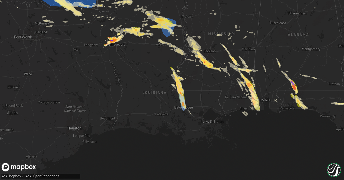
Hail Map in Louisiana on June 17, 2023
Get this storm
June 17 map
$229
one time, instant access
Download today. No call, no setup
Keep the $229
Bought the map and want the full workflow? Apply the entire $229 to a subscription within 7 days. None of it is wasted.
Every map, not just this one
This buys you this map. Subscription and you get every map we run, in the markets you choose from a few cities to whole states to nationwide. Plus real-time alerts the moment a storm fires.
Contact data
Name, contact info, occupancy, even credit band for addresses in the footprint. You go from where it hit to who to call.
Become the source they trust
Unlimited branding weather history reports on demand. You already have the documented answer ready for the property owner, and you are the one who showed up with it.
Property data and RoofTrace estimates
Pull up any address you have got, its value and the exact code rules for that jurisdiction, straight from One Click Code. Then RoofTrace estimates the squares, pitch, and roof value, priced the way you price.
Storm reports in Louisiana
Louisiana
| Date | Description |
|---|---|
| 06/17/20236:55 PM CDT | Social media photos of quarter to half dollar hail in mooringsport. |
| 06/17/20236:50 PM CDT | Hail reported in the woodlake south area near benton. |
| 06/17/20236:45 PM CDT | Hail up to ping pong size reported in the legacy subdivision. |
| 06/17/20236:45 PM CDT | Quarter size hail on palmetto road in benton |
| 06/17/20236:45 PM CDT | Hail reported at mooringsport baptist church. |
| 06/17/20236:42 PM CDT | Ping pong size hail reported between bossier city and benton in the willow heights subdivision. |
| 06/17/20236:40 PM CDT | Ping pong size hail reported between bossier city and benton in the willow heights subdivision. |
| 06/17/20236:25 PM CDT | Hail larger than ping pong size in the town of blanchard... With golf ball size hail reported at elsie truck stop along highway 1. |
| 06/17/20236:20 PM CDT | Hail near 2 inches reported along highway 1 in the blanchard area. |
| 06/17/20236:20 PM CDT | Hail reported larger than golf ball via social media along highway 1 near blanchard. |
| 06/17/20236:20 PM CDT | Quarter size hail posted near the intersection of highway 1 and highway 71. |
| 06/17/20236:20 PM CDT | Quarter size hail posted near the intersection of highway 1 and highway 71 in north shreveport. |
| 06/17/20236:20 PM CDT | Report of 3 inch hail just off old mooringsport road in the blanchard area. |
| 06/17/20236:20 PM CDT | Photo via social media of 3 inch hail just off old mooringsport road in the blanchard area. |
| 06/17/20236:15 PM CDT | Estimated dime to quarter size hail reported by police. |
| 06/17/20235:30 PM CDT | Minor structural damage. Metal roofing from a patio or shed blown onto a house and shingles ripped off. |
| 06/17/20235:23 PM CDT | Measured at top of tiger stadium. |
| 06/17/20235:22 PM CDT | Report from mping: quarter |
| 06/17/20235:20 PM CDT | Public reports on social media a tree is down |
| 06/17/20235:11 PM CDT | Fire department reports a tree on a house at clark drive and rafe mayer rd in unincorporated east baton rouge parish. |
| 06/17/20235:11 PM CDT | Report from mping: 1-inch tree limbs broken; shingles blown off. |
| 06/17/20235:04 PM CDT | Report from mping: ping pong ball |
| 06/17/20235:02 PM CDT | Asos station kbtr baton rouge airport. |
| 06/17/20234:55 PM CDT | Trees and power lines down in the city of baker. |
| 06/17/20234:52 PM CDT | Multiple power poles down along hwy 61. |
| 06/17/20234:50 PM CDT | A local report indicates 1.00 inch wind near Zachary |
| 06/17/20234:42 PM CDT | Quarter size hail. |
| 06/17/20234:29 PM CDT | Large tree down on commerce st blocking the road by the courthouse. |
| 06/17/20234:28 PM CDT | A local report indicates 1.00 inch wind near St. Francisville |
| 06/17/20234:25 PM CDT | Corrects previous tstm wnd dmg report time from 2 nnw st. Francisville. Multiple power poles down along hwy 61. |
| 06/17/20234:25 PM CDT | Shingles blown off roofs of homes in the bluffs subdivision. |
| 06/17/20234:25 PM CDT | Corrects previous tstm wnd dmg report from 2 nnw st. Francisville. Multiple power poles down along hwy 61. |
| 06/17/20234:25 PM CDT | Quarter size hail. |
| 06/17/20234:25 PM CDT | Strong winds also removed some shingles from the roofs of homes in the bluffs subdivision. |
| 06/17/20234:20 PM CDT | Quarter size hail reported at the oaks plantation. |
| 06/17/20234:15 PM CDT | Corrects previous tstm wnd dmg report from 1 e jackson. Quarter size hail. |
| 06/17/20234:15 PM CDT | Quarter size hail. |
| 06/17/20234:15 PM CDT | Multiple trees down around bains and blocking the highways. |
| 06/17/20234:10 PM CDT | Quarter to ping pong ball size hail around lake rosemound. |
| 06/17/20234:07 PM CDT | Hail up to the size of golf balls reported in spillman. |
| 06/17/20236:53 AM CDT | A tree was downed across highway 550 near lem road in the laran community. |
| 06/17/20236:53 AM CDT | Trees were downed across cox ferry road... West bayou street... James avenue... And park street within the farmerville city limits. |
| 06/17/20236:48 AM CDT | Trees down on scotts hideaway road... Corney creek drive... Spring lake road... Webster bluff road... Sandfield road... And masonic road. |
| 06/17/20236:39 AM CDT | A large tree was blown down across newman road near the intersection of tommy green road. |
| 06/17/20236:37 AM CDT | Trees were downed across double bridges road near bernice. |
| 06/17/20236:37 AM CDT | Trees down across pisgah church road in bernice. |
| 06/17/20235:05 AM CDT | A couple lines down and power out on the e side of the parish. |
| 06/17/20234:06 AM CDT | Trees and power lines down across hwy 17... Gaddis street... And koerner street. |
| 06/16/20238:05 PM CDT | Widespread trees and power lines down across the haynesville. |
| 06/16/20237:55 PM CDT | Trees down near intersection of highway 159 and highway 160. |
| 06/16/20237:35 PM CDT | Social media report of dime to quarter size hail in the cotton valley area. |
All States Impacted by Hail Map on June 17, 2023
Cities Impacted by Hail Map on June 17, 2023
- Grinnell, KS
- Hoxie, KS
- Weskan, KS
- Arapahoe, CO
- Sharon Springs, KS
- Wallace, KS
- Orlando, FL
- Malabar, FL
- Palm Bay, FL
- Laurel, MS
- Waynesboro, MS
- Pueblo, CO
- Beulah, CO
- Clayton, LA
- Ferriday, LA
- Vidalia, LA
- Richton, MS
- Newhebron, MS
- Castleberry, AL
- Repton, AL
- Brewton, AL
- Evergreen, AL
- Natchez, MS
- Colorado City, CO
- Rye, CO
- Avondale, CO
- Walsenburg, CO
- Fowler, CO
- Neely, MS
- Leakesville, MS
- Andalusia, AL
- Agate, CO
- Boone, CO
- Jay, FL
- Milton, FL
- Wing, AL
- Louin, MS
- Bay Springs, MS
- Lucedale, MS
- Stringer, MS
- Woodville, MS
- Baker, FL
- Marianna, FL
- Altha, FL
- Blountstown, FL
- Grand Ridge, FL
- Clyde, TX
- Abilene, TX
- Ovalo, TX
- Wilmer, AL
- Centreville, MS
- Holt, FL
- Eglin Afb, FL
- Baird, TX
- Bronte, TX
- Winters, TX
- Norton, TX
- Moss Point, MS
- Mobile, AL
- Grand Bay, AL
- Fort Walton Beach, FL
- Mary Esther, FL
- Hurlburt Field, FL
- Saint Francisville, LA
- Des Moines, NM
- Grenville, NM
- Jackson, LA
- Ethel, LA
- Kim, CO
- La Junta, CO
- Las Animas, CO
- Coden, AL
- Theodore, AL
- Irvington, AL
- Bayou La Batre, AL
- Folsom, NM
- Voss, TX
- Valera, TX
- Coleman, TX
- Gouldbusk, TX
- Santa Anna, TX
- Albany, TX
- Moran, TX
- State Line, MS
- Zachary, LA
- Slaughter, LA
- Baker, LA
- Erwinville, LA
- Baton Rouge, LA
- Talpa, TX
- Port Allen, LA
- Brusly, LA
- Cameron, MO
- Winston, MO
- Kidder, MO
- Hamilton, MO
- Lathrop, MO
- Lawson, MO
- Polo, MO
- Altamont, MO
- Gallatin, MO
- Hooker, OK
- Tyrone, OK
- Weatherby, MO
- Pattonsburg, MO
- Liberal, KS
- Waskom, TX
- Marshall, TX
- Karnack, TX
- McFall, MO
- San Angelo, TX
- Christoval, TX
- Kismet, KS
- Mount Olive, MS
- Manning, IA
- Manilla, IA
- Audubon, IA
- Pascagoula, MS
- Matheson, CO
- Limon, CO
- Nunn, CO
- Grover, CO
- Brooklet, GA
- Pembroke, GA
- Manzanola, CO
- Pritchett, CO
- Shubuta, MS
- Vossburg, MS
- Pachuta, MS
- Gilmore City, IA
- Palmer, IA
- Model, CO
- Byers, CO
- Waterproof, LA
- Strasburg, CO
- New Augusta, MS
- Beaumont, MS
- Rutland, IA
- Humboldt, IA
- Buckatunna, MS
- Raleigh, MS
- Harlan, IA
- Hugo, CO
- Karval, CO
- Havana, FL
- Tallahassee, FL
- Hogansville, GA
- Trinidad, CO
- Forest, MS
- Lake, MS
- Flagler, CO
- Olney Springs, CO
- Rocky Ford, CO
- Arriba, CO
- Vinegar Bend, AL
- Millry, AL
- Quincy, FL
- Wetmore, CO
- Loxahatchee, FL
- Wellington, FL
- Loxley, AL
- Robertsdale, AL
- Gretna, FL
- Chattahoochee, FL
- Opp, AL
- Elba, AL
- Wesson, MS
- Hazlehurst, MS
- Monticello, MS
- Norwood, LA
- Pulaski, MS
- Lena, MS
- Morton, MS
- Heidelberg, MS
- Anton, CO
- Silver Creek, MS
- Georgetown, MS
- Pinola, MS
- Monticello, FL
- Lloyd, FL
- McKenzie, AL
- Brantley, AL
- Dozier, AL
- Red Level, AL
- McLain, MS
- Springfield, CO
- Florence, CO
- Monroeville, AL
- Collins, MS
- Peterman, AL
- Citronelle, AL
- Rose Hill, MS
- Alford, FL
- Fountain, FL
- Chipley, FL
- Bristol, FL
- Greenville, FL
- Pahokee, FL
- Canal Point, FL
- Crestview, FL
- Shalimar, FL
- Live Oak, FL
- Ellisville, MS
- Semmes, AL
- Taylorsville, MS
- Soso, MS
- Paulding, MS
- Ovett, MS
- Quitman, MS
- Dawson, MN
- Petal, MS
- Merkel, TX
- Turpin, OK
- Tye, TX
- Dyess Afb, TX
- Beaver, OK
- Forgan, OK
- Rockwood, TX
- Mereta, TX
- Miles, TX
- Mooringsport, LA
- Shreveport, LA
- Rowena, TX
- Paint Rock, TX
- Ballinger, TX
- Burkett, TX
- Coffey, MO
- Bethany, MO
- Cross Plains, TX
- Brownwood, TX
- Rising Star, TX
- Rochelle, TX
- Brookesmith, TX
- Blanchard, LA
- Millersview, TX
- Borger, TX
- Pampa, TX
- Miami, TX
- Sublette, KS
- Satanta, KS
- Sanderson, FL
- Ridgeway, MO
- Campo, CO
- Boise City, OK
- Kenton, OK
- Felt, OK
- Rolla, KS
- Goodwell, OK
- Walsh, CO
- Elkhart, KS
- Keyes, OK
- Hugoton, KS
- Richfield, KS
- Texhoma, OK
- Snyder, TX
- Manter, KS
- Vilas, CO
- Johnson, KS
- Ulysses, KS
- Benton, LA
- Guymon, OK
- Jayton, TX
- Aspermont, TX
- Rotan, TX
- Stratford, TX
- Hamlin, TX
- Stamford, TX
- Rule, TX
- Trent, TX
- Plains, KS
- Copeland, KS
- Oil City, LA
- Jefferson, TX
- Vivian, LA
- Bossier City, LA
- Laverne, OK
- Moscow, KS
- Garden City, KS
- Lakin, KS
- Gruver, TX
- Texhoma, TX
- Gate, OK
- Anson, TX
- Holcomb, KS
- Montezuma, KS
- Canadian, TX
- Cimarron, KS
- Lohn, TX
- Plain Dealing, LA
- Ingalls, KS
- Meade, KS
- Pierceville, KS
- Casey, IA
- Hawley, TX
- Fontanelle, IA
- Greenfield, IA
- Menlo, IA
- Lueders, TX
- Avoca, TX
- Stuart, IA
- Cisco, TX
- Rosston, OK
- Fowler, KS
- Ensign, KS
- Doole, TX
- Vernon, TX
- Eden, TX
- Frederick, OK
- Loveland, OK
- Dodge City, KS
- Minneola, KS
- Jetmore, KS
- Brady, TX
- May, OK
- Carbon, TX
- Buffalo, OK
- Ford, KS
- Wright, KS
- Chattanooga, OK
- Indiahoma, OK
- Breckenridge, TX
- Haynesville, LA
- Emerson, AR
- Walters, OK
- Fort Supply, OK
- Freedom, OK
- Faxon, OK
- Cache, OK
- Spearville, KS
- Greensburg, KS
- Mullinville, KS
- Bucklin, KS
- Offerle, KS
- Junction City, AR
- Kinsley, KS
- Macksville, KS
- St John, KS
- Mooreland, OK
- Woodward, OK
- Alva, OK
- Burns, KS
- Electra, TX
- Iowa Park, TX
- Haviland, KS
- Lewis, KS
- Glen Saint Mary, FL
- Holliday, TX
- Waynoka, OK
- Cassoday, KS
- Chester, OK
- Dacoma, OK
- Aline, OK
- Carmen, OK
- Wichita Falls, TX
- Fairview, OK
- Seiling, OK
- Cleo Springs, OK
- Ryan, OK
- Waurika, OK
- Burlington, OK
- Cherokee, OK
- Orient, IA
- Helena, OK
- Amorita, OK
- Manchester, OK
- Winterset, IA
- Fargo, OK
- Sharon, OK
- Mutual, OK
- Vici, OK
- Fay, OK
- Taloga, OK
- Custer City, OK
- Thomas, OK
- Weatherford, OK
- Putnam, OK
- Oakwood, OK
- Okarche, OK
- Longdale, OK
- Isabella, OK
- Meno, OK
- Southard, OK
- Calumet, OK
- Geary, OK
- Canton, OK
- Ringwood, OK
- Goltry, OK
- Ames, OK
- Greenfield, OK
- Kingfisher, OK
- Jet, OK
- Hitchcock, OK
- Watonga, OK
- Hennessey, OK
- Omega, OK
- Okeene, OK
- Hinton, OK
- Hydro, OK
- Valley Center, KS
- Wichita, KS
- Arnett, OK
- Camargo, OK
- Nash, OK
- Lahoma, OK
- Waukomis, OK
- Kremlin, OK
- Enid, OK
- Drummond, OK
- Carrier, OK
- Pond Creek, OK
- Medford, OK
- Wakita, OK
- Dover, OK
- Marshall, OK
- Loyal, OK
- Hunter, OK
- Douglas, OK
- Fairmont, OK
- Bison, OK
- Thayer, IA
- Afton, IA
- Murray, IA
- Mobeetie, TX
- Eureka, KS
- Hamilton, KS
- Newton, KS
- Halstead, KS
- Creston, IA
- Wheeler, TX
- Briscoe, TX
- Lenox, IA
- Bedford, IA
- Clearfield, IA
- Early, TX
- Zephyr, TX
- Mullin, TX
- Ringling, OK
- Wilson, OK
- Healdton, OK
- Lone Grove, OK
- Ardmore, OK
- Springer, OK
- Loco, OK
- Sedgwick, KS
- Garber, OK
- Tonkawa, OK
- Deer Creek, OK
- Crescent, OK
- Nardin, OK
- Billings, OK
- Lamont, OK
- Covington, OK
- Braman, OK
- Blackwell, OK
- Binger, OK
- El Reno, OK
- Lookeba, OK
- Larned, KS
- Garfield, KS
- Hanston, KS
- Rozel, KS
- Burdett, KS
- Tishomingo, OK
- Madill, OK
- Mannsville, OK
- Mill Creek, OK
- Belpre, KS
- Great Bend, KS
- Pawnee Rock, KS
- Otis, KS
- Rush Center, KS
- Albert, KS
- Hoisington, KS
- Olmitz, KS
- Bison, KS
- Claflin, KS
- Russell, KS
- Bunker Hill, KS
- Dorrance, KS
- Pratt, KS
- Cunningham, KS
- Byers, KS
- Iuka, KS
- Stafford, KS
- Turon, KS
- Hudson, KS
- Sylvia, KS
- Plevna, KS
- Murdock, KS
- Abbyville, KS
- South Hutchinson, KS
- Haven, KS
- Pretty Prairie, KS
- Kingman, KS
- Partridge, KS
- Arlington, KS
- Cheney, KS
- Nickerson, KS
- Hutchinson, KS
- Buhler, KS
- Sweetwater, OK
- Reydon, OK
- Cheyenne, OK
- Goldthwaite, TX
- Sayre, OK
- Goddard, KS
- Burrton, KS
- Andale, KS
- Colwich, KS
- Bentley, KS
- Garden Plain, KS
- Mount Hope, KS
- Norwich, KS
- Nashville, KS
- Spivey, KS
- Isabel, KS
- Milton, KS
- Viola, KS
- Harper, KS
- Zenda, KS
- Clearwater, KS
- Argonia, KS
- Danville, KS
- Conway Springs, KS
- Sawyer, KS
- Oklahoma City, OK
- Yukon, OK
- Minco, OK
- Union City, OK
- Mustang, OK
- Cashion, OK
- Piedmont, OK
- Mulhall, OK
- Guthrie, OK
- Perry, OK
- Lucien, OK
- Bethany, OK
- Orlando, OK
- Edmond, OK
- Wheatland, OK
- Blanchard, OK
- Tuttle, OK
- Newcastle, OK
- Erick, OK
- Carter, OK
- Willow, OK
- Granite, OK
- Norman, OK
- Coyle, OK
- Jones, OK
- Spencer, OK
- Meridian, OK
- Perkins, OK
- Ponca City, OK
- Morrison, OK
- Harrah, OK
- Arcadia, OK
- Choctaw, OK
- Wellston, OK
- Stillwater, OK
- Carney, OK
- Red Rock, OK
- Luther, OK
- Marland, OK
- Whitewater, KS
- Jefferson, IA
- Vona, CO
- Stratton, CO
- Kit Carson, CO
- Sweetwater, TX
- Maysville, MO
- Dana, IA
- Ogden, IA
- Grand Junction, IA
- Otis, CO
- Crowell, TX
- Ozona, TX
- Cope, CO
- Fulda, MN
- Redfield, IA
- Adair, IA
- Lane, OK
- Stringtown, OK
- Winona, KS
- Cheyenne Wells, CO
- Bangs, TX
- Sharpsburg, IA
- Diagonal, IA
- Gravity, IA
- Rippey, IA
- Pine Hill, AL
- Vredenburgh, AL
- Lower Peach Tree, AL
- Coy, AL
- Gonzales, LA
- Prairieville, LA
- Statesboro, GA
- Lewis, IA
- Atlantic, IA
- Mertzon, TX
- Harrold, TX
- Oklaunion, TX
- Braymer, MO
- Cowgill, MO
- Belcher, LA
- Remsen, IA
- Marcus, IA
- Cotton Valley, LA
- Badger, IA
- Clare, IA
- Fort Dodge, IA
- Jackson, AL
- Englewood, KS
- Bainbridge, GA
- Brinson, GA
- Iron City, GA
- Mize, MS
- Grandfield, OK
- Kingsley, IA
- Lake City, FL
- Lake Butler, FL
- May, TX
- Davidson, OK
- Wiggins, MS
- Blanket, TX
- Ellabell, GA
- Perryton, TX
- Spearman, TX
- Balko, OK
- Destin, FL
- Ashland, KS
- Eola, TX
- Akron, CO
- Palatka, FL
- Gautier, MS
- Clayton, NM
- Coffeeville, AL
- Sarepta, LA
- Crosby, MS
- Roscoe, TX
- Potwin, KS
- El Dorado, KS
- Hardesty, OK
- Lutz, FL
- Tampa, FL
- Land O'Lakes, FL
- New Port Richey, FL
- Odessa, FL
- Port Richey, FL
- Randlett, OK
- Temple, OK
- Byers, TX
- Petrolia, TX
- Seminary, MS
- Panora, IA
- Guthrie Center, IA
- Sorrento, LA
- Climax, GA
- Thomasville, GA
- Cairo, GA
- Fort Lauderdale, FL
- Shongaloo, LA
- Lillie, LA
- Fort White, FL
- Wellborn, FL
- Waldron, KS
- Comanche, OK
- Spearsville, LA
- Duncan, OK
- Brooklyn, MS
- Jonesville, LA
- Roxie, MS
- Quitaque, TX
- Nolan, TX
- Bonaire, GA
- Comanche, TX
- Sidney, TX
- Bluff City, KS
- Devol, OK
- Hastings, OK
- Miami, FL
- Hallandale, FL
- Hollywood, FL
- North Miami Beach, FL
- Anthony, KS
- Attica, KS
- Westboro, MO
- Elmo, MO
- Franklin, AL
- Lincoln, AL
- Sterling, KS
- Wall, TX
- Sentinel, OK
- Lone Wolf, OK
- Newalla, OK
- Mcloud, OK
- Noble, OK
- Glencoe, OK
- Ripley, OK
- Agra, OK
- Chandler, OK
- Tryon, OK
- Wellington, KS
- Haysville, KS
- Peck, KS
- Mulvane, KS
- Derby, KS
- Maize, KS
- Mcconnell Afb, KS
- Canton, KS
- Moundridge, KS
- Hesston, KS
- Mead, OK
- Cartwright, OK
- Kingston, OK
- Colbert, OK
- Calera, OK
- Kenefic, OK
- Bokchito, OK
- Caddo, OK
- Milburn, OK
- Durant, OK
- Ravenna, TX
- Hendrix, OK
- Caney, OK
- Finley, OK
- Coleman, OK
- Antlers, OK
- Moyers, OK
- Bennington, OK
- Atoka, OK
- Boswell, OK
- Clayton, OK
- Snow, OK
- Wapanucka, OK
- Macomb, OK
- Wanette, OK
- Shawnee, OK
- Tecumseh, OK
- Lexington, OK
- Yale, OK
- Pawnee, OK
- Jennings, OK
- Drumright, OK
- Cushing, OK
- Maramec, OK
- Meeker, OK
- Stroud, OK
- Davenport, OK
- Sparks, OK
- Gotebo, OK
- Hobart, OK
- Roosevelt, OK
- Cordell, OK
- Mountain View, OK
- Rocky, OK
- Carnegie, OK
- Rose Hill, KS
- North Newton, KS
- Kechi, KS
- Greenwich, KS
- Benton, KS
- Augusta, KS
- Andover, KS
- Towanda, KS
- Leon, KS
- Prue, OK
- Mannford, OK
- Osage, OK
- Cleveland, OK
- Terlton, OK
- Bristow, OK
- Depew, OK
- Sand Springs, OK
- Fairfax, OK
- Barnsdall, OK
- Skiatook, OK
- Hominy, OK
- Wynona, OK
- Ralston, OK
- Earlsboro, OK
- Kellyville, OK
- Prague, OK
- Castle, OK
- Paden, OK
- Okemah, OK
- Boley, OK
- Seminole, OK
- Sapulpa, OK
- Fort Cobb, OK
- Beggs, OK
- Mounds, OK
- Okmulgee, OK
- Pawhuska, OK
- Telephone, TX
- Sumner, TX
- Rattan, OK
- Grant, OK
- Hugo, OK
- Soper, OK
- Arthur City, TX
- Ivanhoe, TX
- Paris, TX
- Honey Grove, TX
- Powderly, TX
- Mangum, OK
- Wister, OK
- Mccurtain, OK
- Red Oak, OK
- Talihina, OK
- Wilburton, OK
- Tuskahoma, OK
- Poteau, OK
- Howe, OK
- Heavener, OK
- Hodgen, OK
- Waldron, AR
- Hartford, AR
- Bokoshe, OK
- Shady Point, OK
- Keota, OK
- Henryetta, OK
- Kiefer, OK
- Weleetka, OK
- Morris, OK
- Bixby, OK
- Ramona, OK
- Sperry, OK
- Vera, OK
- Collinsville, OK
- Glenpool, OK
- Bartlesville, OK
- Tulsa, OK
- Owasso, OK
- Broken Arrow, OK
- Jenks, OK
- Ochelata, OK
- Rosalia, KS
- Cameron, OK
- Mansfield, AR
- Booneville, AR
- Hackett, AR
- Dill City, OK
- Elk City, OK
- Council Hill, OK
- Haskell, OK
- Catoosa, OK
- Claremore, OK
- Boynton, OK
- Talala, OK
- Oologah, OK
- Coweta, OK
- Pocola, OK
- Midland, AR
- Muldrow, OK
- Spiro, OK
- Huntington, AR
- Inola, OK
- Wagoner, OK
- Chouteau, OK
- Redbird, OK
- Pryor, OK
- Porter, OK
- Chelsea, OK
- Nowata, OK
- Taft, OK
- Oktaha, OK
- Muskogee, OK
- Checotah, OK
- Bagwell, TX
- Bethel, OK
- Rufe, OK
- Detroit, TX
- Idabel, OK
- Broken Bow, OK
- Fort Towson, OK
- Blossom, TX
- Eagletown, OK
- Wright City, OK
- Garvin, OK
- Sawyer, OK
- Ringold, OK
- Clarksville, TX
- Spencerville, OK
- Valliant, OK
- Haworth, OK
- Nashoba, OK
- Charleston, AR
- Fort Smith, AR
- Greenwood, AR
- Barling, AR
- Arkoma, OK
- Lavaca, AR
- Roland, OK
- Van Buren, AR
- Big Cabin, OK
- Fort Gibson, OK
- Adair, OK
- Alma, AR
- Locust Grove, OK
- Hulbert, OK
- Tahlequah, OK
- Peggs, OK
- Braggs, OK
- Salina, OK
- Vinita, OK
- Avery, TX
- De Kalb, TX
- Watson, OK
- Hatfield, AR
- Smithville, OK
- Vandervoort, AR
- Porum, OK
- Cove, AR
- Webbers Falls, OK
- Warner, OK
- Stigler, OK
- Rose, OK
- Strang, OK
- Proctor, OK
- Spavinaw, OK
- Paris, AR
- Subiaco, AR
- Scranton, AR
- Welling, OK
- Park Hill, OK
- Bunch, OK
- Stilwell, OK
- Magazine, AR
- Delaware, AR
- Dardanelle, AR
- New Blaine, AR
- Dover, AR
- Lamar, AR
- Knoxville, AR
- Russellville, AR
- London, AR
- Pottsville, AR
- Afton, OK
- Ketchum, OK
- Noel, MO
- Siloam Springs, AR
- Wyandotte, OK
- Grove, OK
- Maysville, AR
- Watts, OK
- Fayetteville, AR
- Twin Oaks, OK
- Anderson, MO
- Lincoln, AR
- Gravette, AR
- Kansas, OK
- Gentry, AR
- Summers, AR
- South West City, MO
- Oaks, OK
- Prairie Grove, AR
- Westville, OK
- Bentonville, AR
- Colcord, OK
- Jay, OK
- Sulphur Springs, AR
- Decatur, AR
- Eucha, OK
- Tiff City, MO
- Fairland, OK
- Pelsor, AR
- Jerusalem, AR
- Hattieville, AR
- Atkins, AR
- Hector, AR
- Cainsville, MO
- Inman, KS
- Mcpherson, KS
- Shannon City, IA
- Ellston, IA
- Pittsburg, OK
- Springfield, AR
- Higgins, TX
- Okolona, AR
- Prescott, AR
- Ozan, AR
- Gurdon, AR
- Blevins, AR
- Lockesburg, AR
- De Queen, AR
- Hampton, AR
- Washington, AR
- Hope, AR
- Galena, MO
- Cape Fair, MO
- Canute, OK
- Caldwell, KS
- Blanco, OK
- Winfield, KS
- Malvern, AR
- Sims, AR
- Pencil Bluff, AR
- Amity, AR
- Delight, AR
- Murfreesboro, AR
- Gould, OK
- Durham, OK
- Fulton, AR
- Greenbrier, AR
- Conway, AR
- Liberty, KS
- Coffeyville, KS
- Rush Springs, OK
- Ninnekah, OK
- Warren, AR
- Hermitage, AR
- Cyril, OK
- Emmet, AR
- Columbus, AR
- Mineral Springs, AR
- McCaskill, AR
- Nashville, AR
- Bonnerdale, AR
- Houston, AR
- Bigelow, AR
- Perryville, AR
- Perry, AR
- S Coffeyville, OK
- Nocona, TX
- Apache, OK
- Burneyville, OK
- Story, AR
- Mena, AR
- Norman, AR
- Donaldson, AR
- Huntsville, AR
- Foss, OK
- Stinnett, TX
- Butler, OK
- Hammon, OK
- Vinson, OK
- Camden, AR
- Chidester, AR
- Ozark, AR
- Ratcliff, AR
- Hot Springs National Park, AR
- Jessieville, AR
- Madrid, IA
- Kelley, IA
- Slater, IA
- Rogers, AR
- Bradley, OK
- Cecil, AR
- Lorimor, IA
- Lindsay, OK
- Cement, OK
- Fletcher, OK
- Ashdown, AR
- Coalgate, OK
- Solgohachia, AR
- Dexter, IA
- Earlham, IA
- Traskwood, AR
- Mount Ida, AR
- Oden, AR
- Damascus, AR
- Mount Vernon, AR
- Elgin, OK
- Bearden, AR
- Missouri Valley, IA
- Arkadelphia, AR
- Olustee, OK
- Elmer, OK
- South Haven, KS
- Morrilton, AR
- Plumerville, AR
- Tipton, OK
- Jersey, AR
- Banks, AR
- Bismarck, AR
- Pearcy, AR
- Lindsborg, KS
- Harrell, AR
- Leedey, OK
- Chickasha, OK
- Anadarko, OK
- Hollis, OK
- Wellington, TX
- El Dorado, AR
- Quitman, AR
- Rose Bud, AR
- Sulphur, OK
- Centrahoma, OK
- Guyton, GA
- Bloomingdale, GA
- Hartman, AR
- Altus, AR
- Branch, AR
- Coal Hill, AR
- Hartshorne, OK
- Farmington, AR
- Springdale, AR
- Powell, MO
- Seneca, MO
- Goodman, MO
- Stark City, MO
- Fairview, MO
- Pineville, MO
- Pierce City, MO
- Diamond, MO
- Lanagan, MO
- Granby, MO
- Neosho, MO
- Wentworth, MO
- Cave Springs, AR
- Sarcoxie, MO
- Rocky Comfort, MO
- Stella, MO
- Bella Vista, AR
- Centerton, AR
- Hiwasse, AR
- Exeter, MO
- Purdy, MO
- Pea Ridge, AR
- Washburn, MO
- Wheaton, MO
- Seligman, MO
- Garfield, AR
- Lowell, AR
- Monett, MO
- Cassville, MO
- Butterfield, MO
- Bogata, TX
- Deport, TX
- Cookville, TX
- Mount Pleasant, TX
- Montrose, AR
- Crossett, AR
- Hamburg, AR
- Fountain Hill, AR
- Bastrop, LA
- Mer Rouge, LA
- Bonita, LA
- Parkdale, AR
- Portland, AR
- Jones, LA
- Wilmot, AR
- Marietta, OK
- Overbrook, OK
- Brookston, TX
- Vicksburg, MS
- Edwards, MS
- Raymond, MS
- Utica, MS
- Crystal Springs, MS
- Terry, MS
- Stuart, OK
- Kiowa, OK
- Omaha, TX
- Searcy, AR
- Romance, AR
- Aurora, MO
- Roff, OK
- Vilonia, AR
- El Paso, AR
- Foster, OK
- Greenville, TX
- Nevada, TX
- Farmersville, TX
- Caddo Mills, TX
- Tingley, IA
- Osceola, IA
- Summerfield, LA
- Pickens, MS
- Camden, MS
- Bernice, LA
- Henrietta, TX
- Farmerville, LA
- Van Alstyne, TX
- Anna, TX
- Monroe, LA
- Sumrall, MS
- Elmore City, OK
- Alex, OK
- Saint Jo, TX
- Pioneer, LA
- Lake Providence, LA
- Erie, KS
- Stonewall, OK
- Carrollton, MS
- Atlanta, TX
- Homer, LA
- Lisbon, LA
- Foreman, AR
- Walnut Ridge, AR
- Greenwood, MS
- Hernando, MS
- Douglassville, TX
- Prentiss, MS
- Pattonville, TX
- Valley Park, MS
- Mayersville, MS
- Cary, MS
- Rolling Fork, MS
- Yazoo City, MS
- Honobia, OK
- Dubach, LA
- Horatio, AR
- Winthrop, AR
- Taylor, AR
- Springhill, LA
- Rayville, LA
- Oak Ridge, LA
- Enola, AR
- Eudora, AR
- Princeton, TX
- Mckinney, TX
- Blue Ridge, TX
- Melissa, TX
- Alleene, AR
- Nesbit, MS
- Bono, AR
- Oswego, KS
- Strong, AR
- Huttig, AR
- Hot Springs Village, AR
- Marion, LA
- Sulphur Springs, TX
- Cumby, TX
- Mound Valley, KS
- Delhi, LA
- Celeste, TX
- Magnolia, AR
- Altamont, KS
- Edna, KS
- Bartlett, KS
- Beebe, AR
- Texarkana, AR
- Texarkana, TX
- Verona, MO
- Oak Grove, LA
- Sheppard Afb, TX
- Bradley, AR
- Lewisville, AR
- Blair, OK
- Pauls Valley, OK
- Maysville, OK
- Rodessa, LA
- Doddridge, AR
- Ida, LA
- Collinston, LA
- Sterlington, LA
- Wilmar, AR
- Carthage, MS
- Simms, TX
- Talco, TX
- Tupelo, OK
- Royse City, TX
- Welch, OK
- Haughton, LA
- Helena, AR
- West Helena, AR
- Fouke, AR
- Mountain View, MO
- Marlow, OK
- Maud, TX
- New Boston, TX
- Hooks, TX
- Fitzhugh, OK
- McRae, AR
- Whitewright, TX
- Hoxie, AR
- Walnut Grove, MS
- Port Gibson, MS
- Hermanville, MS
- Newellton, LA
- Bolton, MS
- Redwood, MS
- Harrisville, MS
- De Kalb, MS
- Collinsville, MS
- Conehatta, MS
- Decatur, MS
- Union, MS
- Satartia, MS
- Bentonia, MS
- Tallulah, LA
- Grenada, MS
- Kosciusko, MS
- Scooba, MS
- Louisville, MS
- Noxapater, MS
- Braxton, MS
- Winnsboro, LA
- Preston, MS
- Shuqualak, MS
- Roxton, TX
- Baskin, LA
- Lake Cormorant, MS


