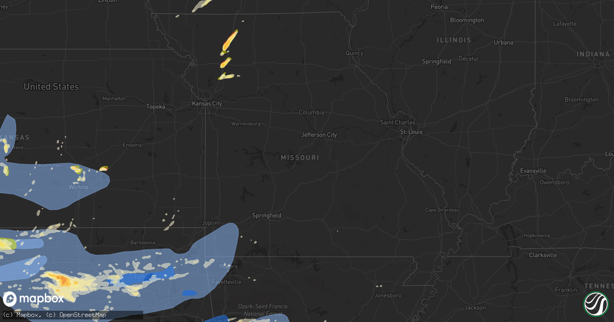
Hail Map in Missouri on June 17, 2023
Get this storm
June 17 map
$229
one time, instant access
Download today. No call, no setup
Keep the $229
Bought the map and want the full workflow? Apply the entire $229 to a subscription within 7 days. None of it is wasted.
Every map, not just this one
This buys you this map. Subscription and you get every map we run, in the markets you choose from a few cities to whole states to nationwide. Plus real-time alerts the moment a storm fires.
Contact data
Name, contact info, occupancy, even credit band for addresses in the footprint. You go from where it hit to who to call.
Become the source they trust
Unlimited branding weather history reports on demand. You already have the documented answer ready for the property owner, and you are the one who showed up with it.
Property data and RoofTrace estimates
Pull up any address you have got, its value and the exact code rules for that jurisdiction, straight from One Click Code. Then RoofTrace estimates the squares, pitch, and roof value, priced the way you price.
Storm reports in Missouri
Missouri
| Date | Description |
|---|---|
| 06/17/20236:10 PM CDT | At least quarter size hail estimated by public via social media. |
| 06/17/20235:50 PM CDT | Public measured 1.75 inch hail reported via social media. |
| 06/17/20235:45 PM CDT | Public report via social media. |
| 06/17/20235:39 PM CDT | A local report indicates 1.00 inch wind near 3 NE Pattonsburg |
| 06/17/20234:58 PM CDT | A local report indicates 1.75 inch wind near 1 N Cameron |
| 06/17/20234:25 AM CDT | A large tree was uprooted and fell on the corner of a home causing minor roof and gutter damage. |
| 06/17/20233:57 AM CDT | Utility company reporting widespread outages with powerlines down. Highest concentration of outages just west of stockton lake. |
| 06/17/20233:28 AM CDT | Delayed report of trees down at state highway 125 and gladetop trail. |
| 06/17/20233:28 AM CDT | Delayed report of tree down on highway 160 near ozark/taney county line. |
| 06/17/20233:23 AM CDT | Tree down in southwest nixa. |
| 06/17/20233:02 AM CDT | Delayed report of tree down at state highway aa. |
| 06/17/20233:00 AM CDT | Delayed report. Tree down blocking the roadway on east highway 248. |
| 06/17/20232:56 AM CDT | Corrects previous tstm wnd dmg report from carthage. Tree limbs down into power lines... Blew transformer. City police reports multiple tree limbs down throughout carth |
| 06/17/20232:56 AM CDT | A power pole was reported down along highway 76. Delayed report. |
| 06/17/20232:53 AM CDT | Large tree branches down on house. |
| 06/17/20232:53 AM CDT | Asos station kjln joplin asos. |
| 06/17/20232:48 AM CDT | Delayed report of 2 trees down across the roadway at hideaway road. |
| 06/17/20232:44 AM CDT | Several large limbs from 3 to 8 inches in diameter were reported down by high winds. |
| 06/17/20232:40 AM CDT | 69 mph wind reported by amateur radio halfway between diamond and wentworth. |
| 06/17/20232:30 AM CDT | Corrects previous tstm wnd dmg report from diamond. Photo posted to facebook of the top of a healthy tree being stripped. |
| 06/17/20232:30 AM CDT | Several large branches reported down due to high winds. |
| 06/17/20232:28 AM CDT | Photos posted to facebook of downed tree limbs. |
| 06/17/20232:22 AM CDT | A local report indicates 62 MPH wind near Neosho |
| 06/17/20232:21 AM CDT | Delayed report. Limbs down across roadway near seligman. |
| 06/17/20232:17 AM CDT | Several photos posted to facebook of large... Healthy trees uprooted... Limbs down... Limbs coming through outbuildings. |
| 06/17/20232:08 AM CDT | Several trees down in the goodman area. |
| 06/17/20232:07 AM CDT | Pictures sent to the office email of large trees uprooted and limbs snapped off large... Healthy trees. Some trees snapped 12 to 15 feet high. |
| 06/17/20232:00 AM CDT | Tree down into an electric transfomer in anderson. |
| 06/17/20231:50 AM CDT | Several trees down in the noel and southwest city area. Time estimated via radar. |
All States Impacted by Hail Map on June 17, 2023
Cities Impacted by Hail Map on June 17, 2023
- Grinnell, KS
- Hoxie, KS
- Weskan, KS
- Arapahoe, CO
- Sharon Springs, KS
- Wallace, KS
- Orlando, FL
- Malabar, FL
- Palm Bay, FL
- Laurel, MS
- Waynesboro, MS
- Pueblo, CO
- Beulah, CO
- Clayton, LA
- Ferriday, LA
- Vidalia, LA
- Richton, MS
- Newhebron, MS
- Castleberry, AL
- Repton, AL
- Brewton, AL
- Evergreen, AL
- Natchez, MS
- Colorado City, CO
- Rye, CO
- Avondale, CO
- Walsenburg, CO
- Fowler, CO
- Neely, MS
- Leakesville, MS
- Andalusia, AL
- Agate, CO
- Boone, CO
- Jay, FL
- Milton, FL
- Wing, AL
- Louin, MS
- Bay Springs, MS
- Lucedale, MS
- Stringer, MS
- Woodville, MS
- Baker, FL
- Marianna, FL
- Altha, FL
- Blountstown, FL
- Grand Ridge, FL
- Clyde, TX
- Abilene, TX
- Ovalo, TX
- Wilmer, AL
- Centreville, MS
- Holt, FL
- Eglin Afb, FL
- Baird, TX
- Bronte, TX
- Winters, TX
- Norton, TX
- Moss Point, MS
- Mobile, AL
- Grand Bay, AL
- Fort Walton Beach, FL
- Mary Esther, FL
- Hurlburt Field, FL
- Saint Francisville, LA
- Des Moines, NM
- Grenville, NM
- Jackson, LA
- Ethel, LA
- Kim, CO
- La Junta, CO
- Las Animas, CO
- Coden, AL
- Theodore, AL
- Irvington, AL
- Bayou La Batre, AL
- Folsom, NM
- Voss, TX
- Valera, TX
- Coleman, TX
- Gouldbusk, TX
- Santa Anna, TX
- Albany, TX
- Moran, TX
- State Line, MS
- Zachary, LA
- Slaughter, LA
- Baker, LA
- Erwinville, LA
- Baton Rouge, LA
- Talpa, TX
- Port Allen, LA
- Brusly, LA
- Cameron, MO
- Winston, MO
- Kidder, MO
- Hamilton, MO
- Lathrop, MO
- Lawson, MO
- Polo, MO
- Altamont, MO
- Gallatin, MO
- Hooker, OK
- Tyrone, OK
- Weatherby, MO
- Pattonsburg, MO
- Liberal, KS
- Waskom, TX
- Marshall, TX
- Karnack, TX
- McFall, MO
- San Angelo, TX
- Christoval, TX
- Kismet, KS
- Mount Olive, MS
- Manning, IA
- Manilla, IA
- Audubon, IA
- Pascagoula, MS
- Matheson, CO
- Limon, CO
- Nunn, CO
- Grover, CO
- Brooklet, GA
- Pembroke, GA
- Manzanola, CO
- Pritchett, CO
- Shubuta, MS
- Vossburg, MS
- Pachuta, MS
- Gilmore City, IA
- Palmer, IA
- Model, CO
- Byers, CO
- Waterproof, LA
- Strasburg, CO
- New Augusta, MS
- Beaumont, MS
- Rutland, IA
- Humboldt, IA
- Buckatunna, MS
- Raleigh, MS
- Harlan, IA
- Hugo, CO
- Karval, CO
- Havana, FL
- Tallahassee, FL
- Hogansville, GA
- Trinidad, CO
- Forest, MS
- Lake, MS
- Flagler, CO
- Olney Springs, CO
- Rocky Ford, CO
- Arriba, CO
- Vinegar Bend, AL
- Millry, AL
- Quincy, FL
- Wetmore, CO
- Loxahatchee, FL
- Wellington, FL
- Loxley, AL
- Robertsdale, AL
- Gretna, FL
- Chattahoochee, FL
- Opp, AL
- Elba, AL
- Wesson, MS
- Hazlehurst, MS
- Monticello, MS
- Norwood, LA
- Pulaski, MS
- Lena, MS
- Morton, MS
- Heidelberg, MS
- Anton, CO
- Silver Creek, MS
- Georgetown, MS
- Pinola, MS
- Monticello, FL
- Lloyd, FL
- McKenzie, AL
- Brantley, AL
- Dozier, AL
- Red Level, AL
- McLain, MS
- Springfield, CO
- Florence, CO
- Monroeville, AL
- Collins, MS
- Peterman, AL
- Citronelle, AL
- Rose Hill, MS
- Alford, FL
- Fountain, FL
- Chipley, FL
- Bristol, FL
- Greenville, FL
- Pahokee, FL
- Canal Point, FL
- Crestview, FL
- Shalimar, FL
- Live Oak, FL
- Ellisville, MS
- Semmes, AL
- Taylorsville, MS
- Soso, MS
- Paulding, MS
- Ovett, MS
- Quitman, MS
- Dawson, MN
- Petal, MS
- Merkel, TX
- Turpin, OK
- Tye, TX
- Dyess Afb, TX
- Beaver, OK
- Forgan, OK
- Rockwood, TX
- Mereta, TX
- Miles, TX
- Mooringsport, LA
- Shreveport, LA
- Rowena, TX
- Paint Rock, TX
- Ballinger, TX
- Burkett, TX
- Coffey, MO
- Bethany, MO
- Cross Plains, TX
- Brownwood, TX
- Rising Star, TX
- Rochelle, TX
- Brookesmith, TX
- Blanchard, LA
- Millersview, TX
- Borger, TX
- Pampa, TX
- Miami, TX
- Sublette, KS
- Satanta, KS
- Sanderson, FL
- Ridgeway, MO
- Campo, CO
- Boise City, OK
- Kenton, OK
- Felt, OK
- Rolla, KS
- Goodwell, OK
- Walsh, CO
- Elkhart, KS
- Keyes, OK
- Hugoton, KS
- Richfield, KS
- Texhoma, OK
- Snyder, TX
- Manter, KS
- Vilas, CO
- Johnson, KS
- Ulysses, KS
- Benton, LA
- Guymon, OK
- Jayton, TX
- Aspermont, TX
- Rotan, TX
- Stratford, TX
- Hamlin, TX
- Stamford, TX
- Rule, TX
- Trent, TX
- Plains, KS
- Copeland, KS
- Oil City, LA
- Jefferson, TX
- Vivian, LA
- Bossier City, LA
- Laverne, OK
- Moscow, KS
- Garden City, KS
- Lakin, KS
- Gruver, TX
- Texhoma, TX
- Gate, OK
- Anson, TX
- Holcomb, KS
- Montezuma, KS
- Canadian, TX
- Cimarron, KS
- Lohn, TX
- Plain Dealing, LA
- Ingalls, KS
- Meade, KS
- Pierceville, KS
- Casey, IA
- Hawley, TX
- Fontanelle, IA
- Greenfield, IA
- Menlo, IA
- Lueders, TX
- Avoca, TX
- Stuart, IA
- Cisco, TX
- Rosston, OK
- Fowler, KS
- Ensign, KS
- Doole, TX
- Vernon, TX
- Eden, TX
- Frederick, OK
- Loveland, OK
- Dodge City, KS
- Minneola, KS
- Jetmore, KS
- Brady, TX
- May, OK
- Carbon, TX
- Buffalo, OK
- Ford, KS
- Wright, KS
- Chattanooga, OK
- Indiahoma, OK
- Breckenridge, TX
- Haynesville, LA
- Emerson, AR
- Walters, OK
- Fort Supply, OK
- Freedom, OK
- Faxon, OK
- Cache, OK
- Spearville, KS
- Greensburg, KS
- Mullinville, KS
- Bucklin, KS
- Offerle, KS
- Junction City, AR
- Kinsley, KS
- Macksville, KS
- St John, KS
- Mooreland, OK
- Woodward, OK
- Alva, OK
- Burns, KS
- Electra, TX
- Iowa Park, TX
- Haviland, KS
- Lewis, KS
- Glen Saint Mary, FL
- Holliday, TX
- Waynoka, OK
- Cassoday, KS
- Chester, OK
- Dacoma, OK
- Aline, OK
- Carmen, OK
- Wichita Falls, TX
- Fairview, OK
- Seiling, OK
- Cleo Springs, OK
- Ryan, OK
- Waurika, OK
- Burlington, OK
- Cherokee, OK
- Orient, IA
- Helena, OK
- Amorita, OK
- Manchester, OK
- Winterset, IA
- Fargo, OK
- Sharon, OK
- Mutual, OK
- Vici, OK
- Fay, OK
- Taloga, OK
- Custer City, OK
- Thomas, OK
- Weatherford, OK
- Putnam, OK
- Oakwood, OK
- Okarche, OK
- Longdale, OK
- Isabella, OK
- Meno, OK
- Southard, OK
- Calumet, OK
- Geary, OK
- Canton, OK
- Ringwood, OK
- Goltry, OK
- Ames, OK
- Greenfield, OK
- Kingfisher, OK
- Jet, OK
- Hitchcock, OK
- Watonga, OK
- Hennessey, OK
- Omega, OK
- Okeene, OK
- Hinton, OK
- Hydro, OK
- Valley Center, KS
- Wichita, KS
- Arnett, OK
- Camargo, OK
- Nash, OK
- Lahoma, OK
- Waukomis, OK
- Kremlin, OK
- Enid, OK
- Drummond, OK
- Carrier, OK
- Pond Creek, OK
- Medford, OK
- Wakita, OK
- Dover, OK
- Marshall, OK
- Loyal, OK
- Hunter, OK
- Douglas, OK
- Fairmont, OK
- Bison, OK
- Thayer, IA
- Afton, IA
- Murray, IA
- Mobeetie, TX
- Eureka, KS
- Hamilton, KS
- Newton, KS
- Halstead, KS
- Creston, IA
- Wheeler, TX
- Briscoe, TX
- Lenox, IA
- Bedford, IA
- Clearfield, IA
- Early, TX
- Zephyr, TX
- Mullin, TX
- Ringling, OK
- Wilson, OK
- Healdton, OK
- Lone Grove, OK
- Ardmore, OK
- Springer, OK
- Loco, OK
- Sedgwick, KS
- Garber, OK
- Tonkawa, OK
- Deer Creek, OK
- Crescent, OK
- Nardin, OK
- Billings, OK
- Lamont, OK
- Covington, OK
- Braman, OK
- Blackwell, OK
- Binger, OK
- El Reno, OK
- Lookeba, OK
- Larned, KS
- Garfield, KS
- Hanston, KS
- Rozel, KS
- Burdett, KS
- Tishomingo, OK
- Madill, OK
- Mannsville, OK
- Mill Creek, OK
- Belpre, KS
- Great Bend, KS
- Pawnee Rock, KS
- Otis, KS
- Rush Center, KS
- Albert, KS
- Hoisington, KS
- Olmitz, KS
- Bison, KS
- Claflin, KS
- Russell, KS
- Bunker Hill, KS
- Dorrance, KS
- Pratt, KS
- Cunningham, KS
- Byers, KS
- Iuka, KS
- Stafford, KS
- Turon, KS
- Hudson, KS
- Sylvia, KS
- Plevna, KS
- Murdock, KS
- Abbyville, KS
- South Hutchinson, KS
- Haven, KS
- Pretty Prairie, KS
- Kingman, KS
- Partridge, KS
- Arlington, KS
- Cheney, KS
- Nickerson, KS
- Hutchinson, KS
- Buhler, KS
- Sweetwater, OK
- Reydon, OK
- Cheyenne, OK
- Goldthwaite, TX
- Sayre, OK
- Goddard, KS
- Burrton, KS
- Andale, KS
- Colwich, KS
- Bentley, KS
- Garden Plain, KS
- Mount Hope, KS
- Norwich, KS
- Nashville, KS
- Spivey, KS
- Isabel, KS
- Milton, KS
- Viola, KS
- Harper, KS
- Zenda, KS
- Clearwater, KS
- Argonia, KS
- Danville, KS
- Conway Springs, KS
- Sawyer, KS
- Oklahoma City, OK
- Yukon, OK
- Minco, OK
- Union City, OK
- Mustang, OK
- Cashion, OK
- Piedmont, OK
- Mulhall, OK
- Guthrie, OK
- Perry, OK
- Lucien, OK
- Bethany, OK
- Orlando, OK
- Edmond, OK
- Wheatland, OK
- Blanchard, OK
- Tuttle, OK
- Newcastle, OK
- Erick, OK
- Carter, OK
- Willow, OK
- Granite, OK
- Norman, OK
- Coyle, OK
- Jones, OK
- Spencer, OK
- Meridian, OK
- Perkins, OK
- Ponca City, OK
- Morrison, OK
- Harrah, OK
- Arcadia, OK
- Choctaw, OK
- Wellston, OK
- Stillwater, OK
- Carney, OK
- Red Rock, OK
- Luther, OK
- Marland, OK
- Whitewater, KS
- Jefferson, IA
- Vona, CO
- Stratton, CO
- Kit Carson, CO
- Sweetwater, TX
- Maysville, MO
- Dana, IA
- Ogden, IA
- Grand Junction, IA
- Otis, CO
- Crowell, TX
- Ozona, TX
- Cope, CO
- Fulda, MN
- Redfield, IA
- Adair, IA
- Lane, OK
- Stringtown, OK
- Winona, KS
- Cheyenne Wells, CO
- Bangs, TX
- Sharpsburg, IA
- Diagonal, IA
- Gravity, IA
- Rippey, IA
- Pine Hill, AL
- Vredenburgh, AL
- Lower Peach Tree, AL
- Coy, AL
- Gonzales, LA
- Prairieville, LA
- Statesboro, GA
- Lewis, IA
- Atlantic, IA
- Mertzon, TX
- Harrold, TX
- Oklaunion, TX
- Braymer, MO
- Cowgill, MO
- Belcher, LA
- Remsen, IA
- Marcus, IA
- Cotton Valley, LA
- Badger, IA
- Clare, IA
- Fort Dodge, IA
- Jackson, AL
- Englewood, KS
- Bainbridge, GA
- Brinson, GA
- Iron City, GA
- Mize, MS
- Grandfield, OK
- Kingsley, IA
- Lake City, FL
- Lake Butler, FL
- May, TX
- Davidson, OK
- Wiggins, MS
- Blanket, TX
- Ellabell, GA
- Perryton, TX
- Spearman, TX
- Balko, OK
- Destin, FL
- Ashland, KS
- Eola, TX
- Akron, CO
- Palatka, FL
- Gautier, MS
- Clayton, NM
- Coffeeville, AL
- Sarepta, LA
- Crosby, MS
- Roscoe, TX
- Potwin, KS
- El Dorado, KS
- Hardesty, OK
- Lutz, FL
- Tampa, FL
- Land O'Lakes, FL
- New Port Richey, FL
- Odessa, FL
- Port Richey, FL
- Randlett, OK
- Temple, OK
- Byers, TX
- Petrolia, TX
- Seminary, MS
- Panora, IA
- Guthrie Center, IA
- Sorrento, LA
- Climax, GA
- Thomasville, GA
- Cairo, GA
- Fort Lauderdale, FL
- Shongaloo, LA
- Lillie, LA
- Fort White, FL
- Wellborn, FL
- Waldron, KS
- Comanche, OK
- Spearsville, LA
- Duncan, OK
- Brooklyn, MS
- Jonesville, LA
- Roxie, MS
- Quitaque, TX
- Nolan, TX
- Bonaire, GA
- Comanche, TX
- Sidney, TX
- Bluff City, KS
- Devol, OK
- Hastings, OK
- Miami, FL
- Hallandale, FL
- Hollywood, FL
- North Miami Beach, FL
- Anthony, KS
- Attica, KS
- Westboro, MO
- Elmo, MO
- Franklin, AL
- Lincoln, AL
- Sterling, KS
- Wall, TX
- Sentinel, OK
- Lone Wolf, OK
- Newalla, OK
- Mcloud, OK
- Noble, OK
- Glencoe, OK
- Ripley, OK
- Agra, OK
- Chandler, OK
- Tryon, OK
- Wellington, KS
- Haysville, KS
- Peck, KS
- Mulvane, KS
- Derby, KS
- Maize, KS
- Mcconnell Afb, KS
- Canton, KS
- Moundridge, KS
- Hesston, KS
- Mead, OK
- Cartwright, OK
- Kingston, OK
- Colbert, OK
- Calera, OK
- Kenefic, OK
- Bokchito, OK
- Caddo, OK
- Milburn, OK
- Durant, OK
- Ravenna, TX
- Hendrix, OK
- Caney, OK
- Finley, OK
- Coleman, OK
- Antlers, OK
- Moyers, OK
- Bennington, OK
- Atoka, OK
- Boswell, OK
- Clayton, OK
- Snow, OK
- Wapanucka, OK
- Macomb, OK
- Wanette, OK
- Shawnee, OK
- Tecumseh, OK
- Lexington, OK
- Yale, OK
- Pawnee, OK
- Jennings, OK
- Drumright, OK
- Cushing, OK
- Maramec, OK
- Meeker, OK
- Stroud, OK
- Davenport, OK
- Sparks, OK
- Gotebo, OK
- Hobart, OK
- Roosevelt, OK
- Cordell, OK
- Mountain View, OK
- Rocky, OK
- Carnegie, OK
- Rose Hill, KS
- North Newton, KS
- Kechi, KS
- Greenwich, KS
- Benton, KS
- Augusta, KS
- Andover, KS
- Towanda, KS
- Leon, KS
- Prue, OK
- Mannford, OK
- Osage, OK
- Cleveland, OK
- Terlton, OK
- Bristow, OK
- Depew, OK
- Sand Springs, OK
- Fairfax, OK
- Barnsdall, OK
- Skiatook, OK
- Hominy, OK
- Wynona, OK
- Ralston, OK
- Earlsboro, OK
- Kellyville, OK
- Prague, OK
- Castle, OK
- Paden, OK
- Okemah, OK
- Boley, OK
- Seminole, OK
- Sapulpa, OK
- Fort Cobb, OK
- Beggs, OK
- Mounds, OK
- Okmulgee, OK
- Pawhuska, OK
- Telephone, TX
- Sumner, TX
- Rattan, OK
- Grant, OK
- Hugo, OK
- Soper, OK
- Arthur City, TX
- Ivanhoe, TX
- Paris, TX
- Honey Grove, TX
- Powderly, TX
- Mangum, OK
- Wister, OK
- Mccurtain, OK
- Red Oak, OK
- Talihina, OK
- Wilburton, OK
- Tuskahoma, OK
- Poteau, OK
- Howe, OK
- Heavener, OK
- Hodgen, OK
- Waldron, AR
- Hartford, AR
- Bokoshe, OK
- Shady Point, OK
- Keota, OK
- Henryetta, OK
- Kiefer, OK
- Weleetka, OK
- Morris, OK
- Bixby, OK
- Ramona, OK
- Sperry, OK
- Vera, OK
- Collinsville, OK
- Glenpool, OK
- Bartlesville, OK
- Tulsa, OK
- Owasso, OK
- Broken Arrow, OK
- Jenks, OK
- Ochelata, OK
- Rosalia, KS
- Cameron, OK
- Mansfield, AR
- Booneville, AR
- Hackett, AR
- Dill City, OK
- Elk City, OK
- Council Hill, OK
- Haskell, OK
- Catoosa, OK
- Claremore, OK
- Boynton, OK
- Talala, OK
- Oologah, OK
- Coweta, OK
- Pocola, OK
- Midland, AR
- Muldrow, OK
- Spiro, OK
- Huntington, AR
- Inola, OK
- Wagoner, OK
- Chouteau, OK
- Redbird, OK
- Pryor, OK
- Porter, OK
- Chelsea, OK
- Nowata, OK
- Taft, OK
- Oktaha, OK
- Muskogee, OK
- Checotah, OK
- Bagwell, TX
- Bethel, OK
- Rufe, OK
- Detroit, TX
- Idabel, OK
- Broken Bow, OK
- Fort Towson, OK
- Blossom, TX
- Eagletown, OK
- Wright City, OK
- Garvin, OK
- Sawyer, OK
- Ringold, OK
- Clarksville, TX
- Spencerville, OK
- Valliant, OK
- Haworth, OK
- Nashoba, OK
- Charleston, AR
- Fort Smith, AR
- Greenwood, AR
- Barling, AR
- Arkoma, OK
- Lavaca, AR
- Roland, OK
- Van Buren, AR
- Big Cabin, OK
- Fort Gibson, OK
- Adair, OK
- Alma, AR
- Locust Grove, OK
- Hulbert, OK
- Tahlequah, OK
- Peggs, OK
- Braggs, OK
- Salina, OK
- Vinita, OK
- Avery, TX
- De Kalb, TX
- Watson, OK
- Hatfield, AR
- Smithville, OK
- Vandervoort, AR
- Porum, OK
- Cove, AR
- Webbers Falls, OK
- Warner, OK
- Stigler, OK
- Rose, OK
- Strang, OK
- Proctor, OK
- Spavinaw, OK
- Paris, AR
- Subiaco, AR
- Scranton, AR
- Welling, OK
- Park Hill, OK
- Bunch, OK
- Stilwell, OK
- Magazine, AR
- Delaware, AR
- Dardanelle, AR
- New Blaine, AR
- Dover, AR
- Lamar, AR
- Knoxville, AR
- Russellville, AR
- London, AR
- Pottsville, AR
- Afton, OK
- Ketchum, OK
- Noel, MO
- Siloam Springs, AR
- Wyandotte, OK
- Grove, OK
- Maysville, AR
- Watts, OK
- Fayetteville, AR
- Twin Oaks, OK
- Anderson, MO
- Lincoln, AR
- Gravette, AR
- Kansas, OK
- Gentry, AR
- Summers, AR
- South West City, MO
- Oaks, OK
- Prairie Grove, AR
- Westville, OK
- Bentonville, AR
- Colcord, OK
- Jay, OK
- Sulphur Springs, AR
- Decatur, AR
- Eucha, OK
- Tiff City, MO
- Fairland, OK
- Pelsor, AR
- Jerusalem, AR
- Hattieville, AR
- Atkins, AR
- Hector, AR
- Cainsville, MO
- Inman, KS
- Mcpherson, KS
- Shannon City, IA
- Ellston, IA
- Pittsburg, OK
- Springfield, AR
- Higgins, TX
- Okolona, AR
- Prescott, AR
- Ozan, AR
- Gurdon, AR
- Blevins, AR
- Lockesburg, AR
- De Queen, AR
- Hampton, AR
- Washington, AR
- Hope, AR
- Galena, MO
- Cape Fair, MO
- Canute, OK
- Caldwell, KS
- Blanco, OK
- Winfield, KS
- Malvern, AR
- Sims, AR
- Pencil Bluff, AR
- Amity, AR
- Delight, AR
- Murfreesboro, AR
- Gould, OK
- Durham, OK
- Fulton, AR
- Greenbrier, AR
- Conway, AR
- Liberty, KS
- Coffeyville, KS
- Rush Springs, OK
- Ninnekah, OK
- Warren, AR
- Hermitage, AR
- Cyril, OK
- Emmet, AR
- Columbus, AR
- Mineral Springs, AR
- McCaskill, AR
- Nashville, AR
- Bonnerdale, AR
- Houston, AR
- Bigelow, AR
- Perryville, AR
- Perry, AR
- S Coffeyville, OK
- Nocona, TX
- Apache, OK
- Burneyville, OK
- Story, AR
- Mena, AR
- Norman, AR
- Donaldson, AR
- Huntsville, AR
- Foss, OK
- Stinnett, TX
- Butler, OK
- Hammon, OK
- Vinson, OK
- Camden, AR
- Chidester, AR
- Ozark, AR
- Ratcliff, AR
- Hot Springs National Park, AR
- Jessieville, AR
- Madrid, IA
- Kelley, IA
- Slater, IA
- Rogers, AR
- Bradley, OK
- Cecil, AR
- Lorimor, IA
- Lindsay, OK
- Cement, OK
- Fletcher, OK
- Ashdown, AR
- Coalgate, OK
- Solgohachia, AR
- Dexter, IA
- Earlham, IA
- Traskwood, AR
- Mount Ida, AR
- Oden, AR
- Damascus, AR
- Mount Vernon, AR
- Elgin, OK
- Bearden, AR
- Missouri Valley, IA
- Arkadelphia, AR
- Olustee, OK
- Elmer, OK
- South Haven, KS
- Morrilton, AR
- Plumerville, AR
- Tipton, OK
- Jersey, AR
- Banks, AR
- Bismarck, AR
- Pearcy, AR
- Lindsborg, KS
- Harrell, AR
- Leedey, OK
- Chickasha, OK
- Anadarko, OK
- Hollis, OK
- Wellington, TX
- El Dorado, AR
- Quitman, AR
- Rose Bud, AR
- Sulphur, OK
- Centrahoma, OK
- Guyton, GA
- Bloomingdale, GA
- Hartman, AR
- Altus, AR
- Branch, AR
- Coal Hill, AR
- Hartshorne, OK
- Farmington, AR
- Springdale, AR
- Powell, MO
- Seneca, MO
- Goodman, MO
- Stark City, MO
- Fairview, MO
- Pineville, MO
- Pierce City, MO
- Diamond, MO
- Lanagan, MO
- Granby, MO
- Neosho, MO
- Wentworth, MO
- Cave Springs, AR
- Sarcoxie, MO
- Rocky Comfort, MO
- Stella, MO
- Bella Vista, AR
- Centerton, AR
- Hiwasse, AR
- Exeter, MO
- Purdy, MO
- Pea Ridge, AR
- Washburn, MO
- Wheaton, MO
- Seligman, MO
- Garfield, AR
- Lowell, AR
- Monett, MO
- Cassville, MO
- Butterfield, MO
- Bogata, TX
- Deport, TX
- Cookville, TX
- Mount Pleasant, TX
- Montrose, AR
- Crossett, AR
- Hamburg, AR
- Fountain Hill, AR
- Bastrop, LA
- Mer Rouge, LA
- Bonita, LA
- Parkdale, AR
- Portland, AR
- Jones, LA
- Wilmot, AR
- Marietta, OK
- Overbrook, OK
- Brookston, TX
- Vicksburg, MS
- Edwards, MS
- Raymond, MS
- Utica, MS
- Crystal Springs, MS
- Terry, MS
- Stuart, OK
- Kiowa, OK
- Omaha, TX
- Searcy, AR
- Romance, AR
- Aurora, MO
- Roff, OK
- Vilonia, AR
- El Paso, AR
- Foster, OK
- Greenville, TX
- Nevada, TX
- Farmersville, TX
- Caddo Mills, TX
- Tingley, IA
- Osceola, IA
- Summerfield, LA
- Pickens, MS
- Camden, MS
- Bernice, LA
- Henrietta, TX
- Farmerville, LA
- Van Alstyne, TX
- Anna, TX
- Monroe, LA
- Sumrall, MS
- Elmore City, OK
- Alex, OK
- Saint Jo, TX
- Pioneer, LA
- Lake Providence, LA
- Erie, KS
- Stonewall, OK
- Carrollton, MS
- Atlanta, TX
- Homer, LA
- Lisbon, LA
- Foreman, AR
- Walnut Ridge, AR
- Greenwood, MS
- Hernando, MS
- Douglassville, TX
- Prentiss, MS
- Pattonville, TX
- Valley Park, MS
- Mayersville, MS
- Cary, MS
- Rolling Fork, MS
- Yazoo City, MS
- Honobia, OK
- Dubach, LA
- Horatio, AR
- Winthrop, AR
- Taylor, AR
- Springhill, LA
- Rayville, LA
- Oak Ridge, LA
- Enola, AR
- Eudora, AR
- Princeton, TX
- Mckinney, TX
- Blue Ridge, TX
- Melissa, TX
- Alleene, AR
- Nesbit, MS
- Bono, AR
- Oswego, KS
- Strong, AR
- Huttig, AR
- Hot Springs Village, AR
- Marion, LA
- Sulphur Springs, TX
- Cumby, TX
- Mound Valley, KS
- Delhi, LA
- Celeste, TX
- Magnolia, AR
- Altamont, KS
- Edna, KS
- Bartlett, KS
- Beebe, AR
- Texarkana, AR
- Texarkana, TX
- Verona, MO
- Oak Grove, LA
- Sheppard Afb, TX
- Bradley, AR
- Lewisville, AR
- Blair, OK
- Pauls Valley, OK
- Maysville, OK
- Rodessa, LA
- Doddridge, AR
- Ida, LA
- Collinston, LA
- Sterlington, LA
- Wilmar, AR
- Carthage, MS
- Simms, TX
- Talco, TX
- Tupelo, OK
- Royse City, TX
- Welch, OK
- Haughton, LA
- Helena, AR
- West Helena, AR
- Fouke, AR
- Mountain View, MO
- Marlow, OK
- Maud, TX
- New Boston, TX
- Hooks, TX
- Fitzhugh, OK
- McRae, AR
- Whitewright, TX
- Hoxie, AR
- Walnut Grove, MS
- Port Gibson, MS
- Hermanville, MS
- Newellton, LA
- Bolton, MS
- Redwood, MS
- Harrisville, MS
- De Kalb, MS
- Collinsville, MS
- Conehatta, MS
- Decatur, MS
- Union, MS
- Satartia, MS
- Bentonia, MS
- Tallulah, LA
- Grenada, MS
- Kosciusko, MS
- Scooba, MS
- Louisville, MS
- Noxapater, MS
- Braxton, MS
- Winnsboro, LA
- Preston, MS
- Shuqualak, MS
- Roxton, TX
- Baskin, LA
- Lake Cormorant, MS


