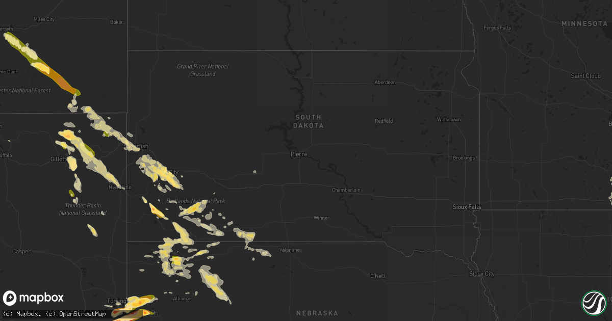
Hail Map in South Dakota on June 17, 2015
Get this storm
June 17 map
$229
one time, instant access
Download today. No call, no setup
Keep the $229
Bought the map and want the full workflow? Apply the entire $229 to a subscription within 7 days. None of it is wasted.
Every map, not just this one
This buys you this map. Subscription and you get every map we run, in the markets you choose from a few cities to whole states to nationwide. Plus real-time alerts the moment a storm fires.
Contact data
Name, contact info, occupancy, even credit band for addresses in the footprint. You go from where it hit to who to call.
Become the source they trust
Unlimited branding weather history reports on demand. You already have the documented answer ready for the property owner, and you are the one who showed up with it.
Property data and RoofTrace estimates
Pull up any address you have got, its value and the exact code rules for that jurisdiction, straight from One Click Code. Then RoofTrace estimates the squares, pitch, and roof value, priced the way you price.
Storm reports in South Dakota
South Dakota
| Date | Description |
|---|---|
| 06/17/20156:50 PM CDT | Report from nssl shave project |
| 06/17/20156:45 PM CDT | A local report indicates 1.00 inch wind near 1 WSW DOWNTOWN RAPID CI |
| 06/17/20156:45 PM CDT | A local report indicates 1.00 inch wind near 2 SW DOWNTOWN RAPID CIT |
| 06/17/20152:30 AM CDT | Torrential rainfall - 0.94 in less than an hour. |
| 06/17/20152:30 AM CDT | A local report indicates 70 MPH wind near MARTIN |
| 06/17/20152:20 AM CDT | A local report indicates 60 MPH wind near VETAL |
| 06/17/20152:00 AM CDT | Torrential rainfall - 0.94 in less than an hour. |
| 06/17/20152:00 AM CDT | A local report indicates 70 MPH wind near MARTIN |
| 06/17/20151:41 AM CDT | A local report indicates 61 MPH wind near 5 NE PORCUPINE |
| 06/17/20151:33 AM CDT | A local report indicates 61 MPH wind near 3 ESE PINE RIDGE |
| 06/17/20151:30 AM CDT | A local report indicates 65 MPH wind near 5 S KYLE |
| 06/17/20151:22 AM CDT | A local report indicates 60 MPH wind near OGLALA |
| 06/17/20151:12 AM CDT | A local report indicates 60 MPH wind near OGLALA |
| 06/17/201512:45 AM CDT | Pea to dime size hail |
| 06/17/201512:30 AM CDT | Report relayed via twitter |
| 06/17/201512:30 AM CDT | Report relayed via twitter |
| 06/16/201511:52 PM CDT | A local report indicates 1.50 inch wind near 2 ESE DOWNTOWN RAPID CI |
| 06/16/201511:50 PM CDT | A local report indicates 1.25 inch wind near 2 E DOWNTOWN RAPID CITY |
| 06/16/201511:49 PM CDT | A local report indicates 58 MPH wind near 4 S DOWNTOWN RAPID CITY |
| 06/16/201511:45 PM CDT | Patio furniture damaged - found 100 yards from property. |
| 06/16/201511:41 PM CDT | A local report indicates 58 MPH wind near 4 S DOWNTOWN RAPID CITY |
| 06/16/201511:35 PM CDT | A local report indicates 1.00 inch wind near 3 N SHERIDAN LAKE |
| 06/16/201511:30 PM CDT | A local report indicates 1.50 inch wind near 8 W ROCKYFORD |
| 06/16/201510:15 PM CDT | A local report indicates 1.00 inch wind near 2 ENE SLIM BUTTE |
| 06/16/20157:20 PM CDT | Hail lasted 10-15 minutes. Mainly quarters with a few golf balls. |
| 06/16/20157:17 PM CDT | Hail covering roads |
| 06/16/20157:17 PM CDT | A local report indicates 1.75 inch wind near 7 SSE DOWNTOWN RAPID CI |
All States Impacted by Hail Map on June 17, 2015
Cities Impacted by Hail Map on June 17, 2015
- Gillette, WY
- Weston, WY
- Plainville, KS
- Santa Fe, NM
- Baconton, GA
- Hardin, MT
- New Richland, MN
- Effingham, SC
- Timmonsville, SC
- Dublin, GA
- Otter, MT
- Clarks Grove, MN
- Albert Lea, MN
- Lavina, MT
- Upton, WY
- Lagrange, WY
- Hawk Springs, WY
- Alton, VA
- Ringgold, VA
- Milton, NC
- Sutherlin, VA
- Blanch, NC
- Rozet, WY
- Caputa, SD
- Rapid City, SD
- Moorcroft, WY
- Crawford, NE
- Whitney, NE
- Hill City, SD
- Yoder, WY
- Tuthill, SD
- Nemo, SD
- Piedmont, SD
- Deadwood, SD
- Sturgis, SD
- Martin, SD
- Aurora, CO
- Ellsworth, NE
- Rushville, NE
- Gordon, NE
- Merriman, NE
- Bingham, NE
- Chula, GA
- Olive, MT
- Broadus, MT
- Prospect, VA
- Farmville, VA
- Hay Springs, NE
- Forsyth, MT
- Volborg, MT
- Kilgore, NE
- Nenzel, NE
- Cairo, IL
- Charleston, MO
- Morrisville, NC
- Garner, NC
- Cary, NC
- Raleigh, NC
- Oral, SD
- Custer, SD
- Buffalo Gap, SD
- Hot Springs, SD
- Angier, NC
- Chadron, NE
- Rocky Mount, VA
- Scottsbluff, NE
- Gering, NE
- Lillington, NC
- Spearfish, SD
- Beulah, WY
- Stockton, KS
- Hulett, WY
- Tallahassee, FL
- Thomasville, GA
- Cairo, GA
- Lecanto, FL
- Monticello, FL
- Sanford, NC
- Princeton, KY
- Peebles, OH
- West Union, OH
- Alzada, MT
- Wrightsville, GA
- Eddyville, KY
- Kuttawa, KY
- Fredonia, KY
- Marion, KY
- Danville, VA
- Blairs, VA
- Martinsville, VA
- Batesland, SD
- Lead, SD
- Aladdin, WY
- Sundance, WY
- Spottsville, KY
- Henderson, KY
- Alden, MN
- Lyman, NE
- Brooksville, FL
- Marion, NC
- Pine Ridge, SD
- Ashby, NE
- Moriarty, NM
- Alliance, NE
- Mitchell, NE
- Harrison, NE
- Torrington, WY
- Morrill, NE
- Westcliffe, CO
- La Mesa, NM
- Bennett, CO
- Watkins, CO
- Collyer, KS
- Newcastle, WY
- Hysham, MT
- Belle Fourche, SD
- Cullowhee, NC
- Healy, KS
- Osage, WY
- Semora, NC
- Leasburg, NC
- Roxboro, NC
- Coward, SC
- Olanta, SC
- Scranton, SC
- Lake City, SC
- Rainsville, AL
- Fyffe, AL
- Silver City, NM
- Rocky Mount, NC
- Spring Hope, NC
- Nashville, NC
- Elm City, NC
- Tularosa, NM
- Douglas, GA
- Florence, AL
- Pollocksville, NC
- Wirtz, VA
- Rio Grande City, TX
- Roma, TX
- Culbertson, NE
- Lynchburg, SC
- Lance Creek, WY
- Kyle, SD
- Sycamore, GA
- Oelrichs, SD
- Wakeeney, KS
- Quinter, KS
- Ocate, NM
- Guadalupita, NM
- Radford, VA
- Laredo, TX
- Realitos, TX
- Black Hawk, SD
- Hermosa, SD
- Pecos, NM
- Henry, VA
- Smithfield, NC
- Morris, GA
- Fort Gaines, GA
- Georgetown, GA
- Boston, GA
- Dixie, GA
- Evansville, IN
- Wadesville, IN
- Sardinia, OH
- Pamplico, SC
- Alamogordo, NM
- Wagon Mound, NM
- Allen, SD
- Ellendale, MN
- Clinton, NC
- Oneonta, AL
- Colorado Springs, CO
- Divide, CO
- Parker, CO
- Manderson, SD
- Porcupine, SD
- Wounded Knee, SD
- Maysville, NC
- Gresham, SC
- Chatham, VA
- Appomattox, VA
- Biscoe, NC
- Cody, NE
- Freer, TX
- Alva, WY
- Albany, GA
- Doerun, GA
- Camilla, GA
- Keystone, SD
- Bassett, VA
- Willacoochee, GA
- Ferrum, VA
- Cloudcroft, NM
- Blackshear, GA
- Gordonsville, VA
- Keswick, VA
- Barboursville, VA
- New Underwood, SD
- Santa Rosa, NM
- Hemingford, NE
- Marsland, NE
- Denton, NC
- Cheyenne, WY
- New Bern, NC
- Cadwell, GA
- McRae Helena, GA
- Alice, TX
- East Dublin, GA
- Roundup, MT
- Saint Matthews, SC
- Collinsville, VA
- Axton, VA
- Fieldale, VA
- Sale City, GA
- Fort Sumner, NM
- Richland, GA
- Hiwassee, VA
- Victoria, KS
- Coxs Mills, WV
- Candor, NC
- Troy, NC
- Lake City, FL
- Veteran, WY
- Strasburg, CO
- Princeton, NC
- Goldsboro, NC
- Linn, WV
- Troy, WV
- Glenville, WV
- Aynor, SC
- Galivants Ferry, SC
- Woodston, KS
- Apex, NC
- Asheboro, NC
- Hardy, VA
- Boones Mill, VA
- Pearson, GA
- Minatare, NE
- Ocala, FL
- Reddick, FL
- Morriston, FL
- Dawson Springs, KY
- La Luz, NM
- Vaughn, NM
- Pamplin, VA
- Las Vegas, NM
- Abbeville, AL
- Fuquay Varina, NC
- Holly Springs, NC
- Metropolis, IL
- Belknap, IL
- Orange Grove, TX
- Tifton, GA
- Callands, VA
- Comstock, NE
- Ridgeway, VA
- Palco, KS
- Broadway, NC
- Chauncey, GA
- Geneva, MN
- Blooming Prairie, MN
- Hartland, MN
- Waseca, MN
- Sandy Level, VA
- Goodview, VA
- Bedford, VA
- Moneta, VA
- Providence, NC
- Banner, WY
- Clearmont, WY
- Thomasville, AL
- Dunn, NC
- Alton, KS
- Vinton, VA
- Vernon Hill, VA
- South Boston, VA
- Halifax, VA
- Wetumpka, AL
- Lawrenceburg, TN
- Eufaula, AL
- Alum Bridge, WV
- Weston, WV
- Auburn, WV
- Smithville, WV
- Weston, CO
- Ord, NE
- Moncure, NC
- New Hill, NC
- Judith Gap, MT
- Garfield, NM
- Clarion, IA
- Newton Grove, NC
- Four Oaks, NC
- Raton, NM
- Belmond, IA
- Penrose, CO
- Comfort, TX
- Boerne, TX
- Maxwell, NE
- Radcliffe, IA
- Williams, IA
- Alden, IA
- Hubbard, IA
- Hayes Center, NE
- Hyannis, NE
- Mount Vernon, IN
- Castle Rock, CO
- Walsenburg, CO
- Glade Hill, VA
- Callaway, VA
- Penhook, VA
- Wray, GA
- Ocilla, GA
- Shepherd, MT
- Fountain, FL
- Austin, MN
- Trenton, NE
- Hollandale, MN
- Hayward, MN
- Cameron, SC
- Orangeburg, SC
- Roanoke, VA
- Bunnlevel, NC
- Philpot, KY
- Sanders, MT
- Whigham, GA
- Pelham, GA
- Winchester, OH
- Georgetown, OH
- Bethel, OH
- Mount Orab, OH
- Fairburn, SD
- Alamo, GA
- Roswell, NM
- Crystal River, FL
- Eclectic, AL
- Hebbronville, TX
- Willow Spring, NC
- State Road, NC
- Cascade, VA
- La Grange, NC
- Wanblee, SD
- Cameron, NC
- Sumter, SC
- Selmer, TN
- Gove, KS
- Trinidad, CO
- Bristol, FL
- Decherd, TN
- Durham, NC
- Conger, MN
- Glenville, MN
- Twin Lakes, MN
- Emmons, MN
- Wells, MN
- Freeborn, MN
- Stuart, VA
- Yanceyville, NC
- Dry Fork, VA
- Keeling, VA
- Yeso, NM
- Cadiz, KY
- Mills, NM
- Greenville, FL
- Williston, FL
- Rowan, IA
- Centennial, WY
- Las Cruces, NM
- Patrick Springs, VA
- Kenna, WV
- Advent, WV
- Ripley, WV
- Gandeeville, WV
- Dawson, GA
- Beverly Hills, FL
- Trementina, NM
- Conchas Dam, NM
- Scenic, SD
- Inverness, FL
- Seven Springs, NC
- Midland, SD
- Hazlehurst, GA
- Denton, GA
- Laramie, WY
- Rosebud, MT
- Biddle, MT
- Owatonna, MN
- Hope, MN
- Guyton, GA


