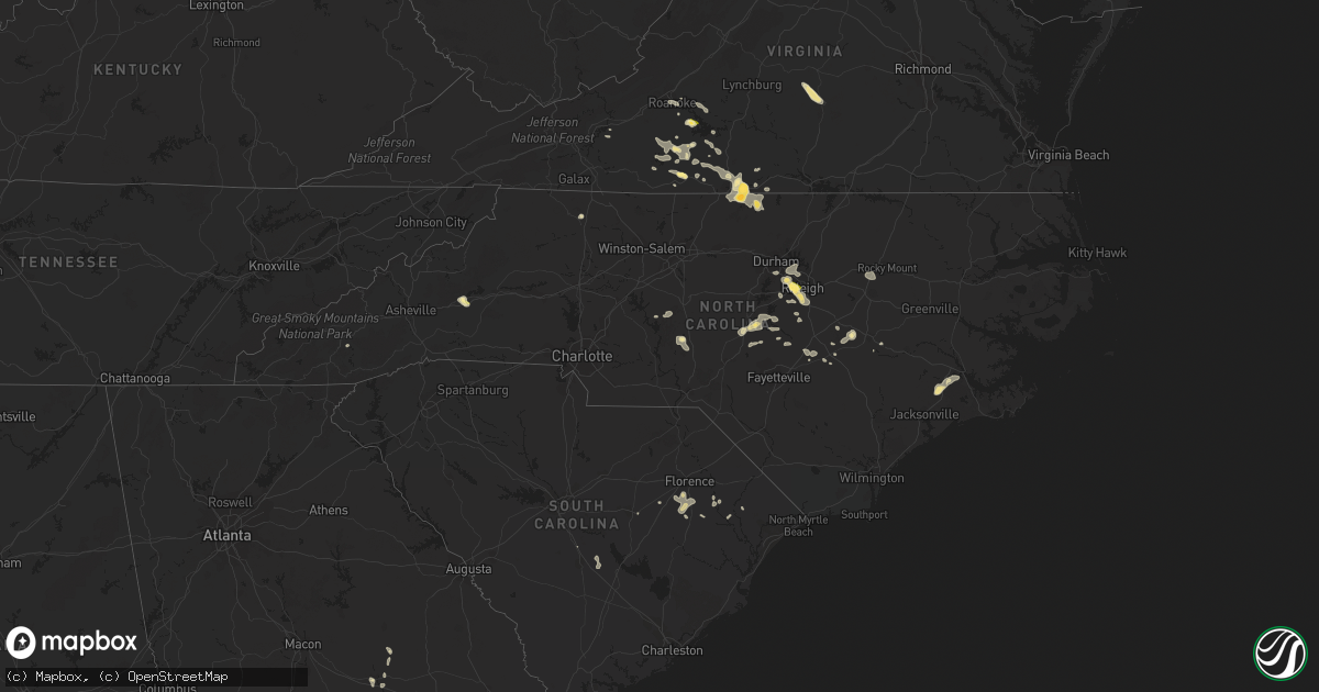
Hail Map in North Carolina on June 17, 2015
Get this storm
June 17 map
$229
one time, instant access
Download today. No call, no setup
Keep the $229
Bought the map and want the full workflow? Apply the entire $229 to a subscription within 7 days. None of it is wasted.
Every map, not just this one
This buys you this map. Subscription and you get every map we run, in the markets you choose from a few cities to whole states to nationwide. Plus real-time alerts the moment a storm fires.
Contact data
Name, contact info, occupancy, even credit band for addresses in the footprint. You go from where it hit to who to call.
Become the source they trust
Unlimited branding weather history reports on demand. You already have the documented answer ready for the property owner, and you are the one who showed up with it.
Property data and RoofTrace estimates
Pull up any address you have got, its value and the exact code rules for that jurisdiction, straight from One Click Code. Then RoofTrace estimates the squares, pitch, and roof value, priced the way you price.
Storm reports in North Carolina
North Carolina
| Date | Description |
|---|---|
| 06/17/20156:54 PM CDT | Numerous trees were reported down across the road and on houses along morton pulliam road between semora road and jack hambrick road. |
| 06/17/20156:25 PM CDT | Many trees and power lines blown down in and around the campus of western carolina university. |
| 06/17/20155:05 PM CDT | Large tree down on island creek road. |
| 06/17/20154:01 PM CDT | Tree down on power line on twin oaks road and snowhill church road |
| 06/17/20154:00 PM CDT | Power line down on twin oaks road near zephyr rd |
| 06/17/20153:55 PM CDT | Tree down on bert cockerman road |
| 06/17/20153:38 PM CDT | Volunteer fire fighter reports quarter sized hail at the loves travel stop at exit 86 off interstate 40. |
| 06/17/20153:23 PM CDT | A local report indicates 1.00 inch wind near MARION |
| 06/17/20153:21 PM CDT | A local report indicates 1.00 inch wind near MARION |
| 06/17/20153:00 PM CDT | Trees and power lines down at intersection of school street and virginia road. |
| 06/17/20152:52 PM CDT | Tree blown down at emergency management center at south gordon and east court streets. Time estimated by radar. |
| 06/16/201511:35 PM CDT | Tree down. Report from wral traffic. |
| 06/16/201511:30 PM CDT | Several powerlines down around angier. |
| 06/16/201511:03 PM CDT | Trees down in sanford. One tree blocking the ems garage. |
| 06/16/201511:00 PM CDT | Along main st in milton. Time estimated by radar |
| 06/16/201511:00 PM CDT | Several reports of trees down in several places in milton. Time estimated by radar. |
| 06/16/201510:57 PM CDT | A local report indicates 1.00 inch wind near MILTON |
| 06/16/201510:50 PM CDT | Trees down in sanford. One tree blocking the ems garage. |
| 06/16/201510:30 PM CDT | Several powerlines down around angier. |
| 06/16/201510:25 PM CDT | Multiple trees down across roadway. |
| 06/16/20159:45 PM CDT | Nc state campus. Lasted about 15 minutes. |
| 06/16/20159:38 PM CDT | Half dollar size hail possibly some larger was reported near the interchange of us highway 1 and walnut st. |
| 06/16/20159:30 PM CDT | Tree down on powelines on chapel hill rd at sorrell st. Report from wral traffic. |
| 06/16/20159:23 PM CDT | Tree down on a house. 100 block of honeysuckle lane |
All States Impacted by Hail Map on June 17, 2015
Cities Impacted by Hail Map on June 17, 2015
- Gillette, WY
- Weston, WY
- Plainville, KS
- Santa Fe, NM
- Baconton, GA
- Hardin, MT
- New Richland, MN
- Effingham, SC
- Timmonsville, SC
- Dublin, GA
- Otter, MT
- Clarks Grove, MN
- Albert Lea, MN
- Lavina, MT
- Upton, WY
- Lagrange, WY
- Hawk Springs, WY
- Alton, VA
- Ringgold, VA
- Milton, NC
- Sutherlin, VA
- Blanch, NC
- Rozet, WY
- Caputa, SD
- Rapid City, SD
- Moorcroft, WY
- Crawford, NE
- Whitney, NE
- Hill City, SD
- Yoder, WY
- Tuthill, SD
- Nemo, SD
- Piedmont, SD
- Deadwood, SD
- Sturgis, SD
- Martin, SD
- Aurora, CO
- Ellsworth, NE
- Rushville, NE
- Gordon, NE
- Merriman, NE
- Bingham, NE
- Chula, GA
- Olive, MT
- Broadus, MT
- Prospect, VA
- Farmville, VA
- Hay Springs, NE
- Forsyth, MT
- Volborg, MT
- Kilgore, NE
- Nenzel, NE
- Cairo, IL
- Charleston, MO
- Morrisville, NC
- Garner, NC
- Cary, NC
- Raleigh, NC
- Oral, SD
- Custer, SD
- Buffalo Gap, SD
- Hot Springs, SD
- Angier, NC
- Chadron, NE
- Rocky Mount, VA
- Scottsbluff, NE
- Gering, NE
- Lillington, NC
- Spearfish, SD
- Beulah, WY
- Stockton, KS
- Hulett, WY
- Tallahassee, FL
- Thomasville, GA
- Cairo, GA
- Lecanto, FL
- Monticello, FL
- Sanford, NC
- Princeton, KY
- Peebles, OH
- West Union, OH
- Alzada, MT
- Wrightsville, GA
- Eddyville, KY
- Kuttawa, KY
- Fredonia, KY
- Marion, KY
- Danville, VA
- Blairs, VA
- Martinsville, VA
- Batesland, SD
- Lead, SD
- Aladdin, WY
- Sundance, WY
- Spottsville, KY
- Henderson, KY
- Alden, MN
- Lyman, NE
- Brooksville, FL
- Marion, NC
- Pine Ridge, SD
- Ashby, NE
- Moriarty, NM
- Alliance, NE
- Mitchell, NE
- Harrison, NE
- Torrington, WY
- Morrill, NE
- Westcliffe, CO
- La Mesa, NM
- Bennett, CO
- Watkins, CO
- Collyer, KS
- Newcastle, WY
- Hysham, MT
- Belle Fourche, SD
- Cullowhee, NC
- Healy, KS
- Osage, WY
- Semora, NC
- Leasburg, NC
- Roxboro, NC
- Coward, SC
- Olanta, SC
- Scranton, SC
- Lake City, SC
- Rainsville, AL
- Fyffe, AL
- Silver City, NM
- Rocky Mount, NC
- Spring Hope, NC
- Nashville, NC
- Elm City, NC
- Tularosa, NM
- Douglas, GA
- Florence, AL
- Pollocksville, NC
- Wirtz, VA
- Rio Grande City, TX
- Roma, TX
- Culbertson, NE
- Lynchburg, SC
- Lance Creek, WY
- Kyle, SD
- Sycamore, GA
- Oelrichs, SD
- Wakeeney, KS
- Quinter, KS
- Ocate, NM
- Guadalupita, NM
- Radford, VA
- Laredo, TX
- Realitos, TX
- Black Hawk, SD
- Hermosa, SD
- Pecos, NM
- Henry, VA
- Smithfield, NC
- Morris, GA
- Fort Gaines, GA
- Georgetown, GA
- Boston, GA
- Dixie, GA
- Evansville, IN
- Wadesville, IN
- Sardinia, OH
- Pamplico, SC
- Alamogordo, NM
- Wagon Mound, NM
- Allen, SD
- Ellendale, MN
- Clinton, NC
- Oneonta, AL
- Colorado Springs, CO
- Divide, CO
- Parker, CO
- Manderson, SD
- Porcupine, SD
- Wounded Knee, SD
- Maysville, NC
- Gresham, SC
- Chatham, VA
- Appomattox, VA
- Biscoe, NC
- Cody, NE
- Freer, TX
- Alva, WY
- Albany, GA
- Doerun, GA
- Camilla, GA
- Keystone, SD
- Bassett, VA
- Willacoochee, GA
- Ferrum, VA
- Cloudcroft, NM
- Blackshear, GA
- Gordonsville, VA
- Keswick, VA
- Barboursville, VA
- New Underwood, SD
- Santa Rosa, NM
- Hemingford, NE
- Marsland, NE
- Denton, NC
- Cheyenne, WY
- New Bern, NC
- Cadwell, GA
- McRae Helena, GA
- Alice, TX
- East Dublin, GA
- Roundup, MT
- Saint Matthews, SC
- Collinsville, VA
- Axton, VA
- Fieldale, VA
- Sale City, GA
- Fort Sumner, NM
- Richland, GA
- Hiwassee, VA
- Victoria, KS
- Coxs Mills, WV
- Candor, NC
- Troy, NC
- Lake City, FL
- Veteran, WY
- Strasburg, CO
- Princeton, NC
- Goldsboro, NC
- Linn, WV
- Troy, WV
- Glenville, WV
- Aynor, SC
- Galivants Ferry, SC
- Woodston, KS
- Apex, NC
- Asheboro, NC
- Hardy, VA
- Boones Mill, VA
- Pearson, GA
- Minatare, NE
- Ocala, FL
- Reddick, FL
- Morriston, FL
- Dawson Springs, KY
- La Luz, NM
- Vaughn, NM
- Pamplin, VA
- Las Vegas, NM
- Abbeville, AL
- Fuquay Varina, NC
- Holly Springs, NC
- Metropolis, IL
- Belknap, IL
- Orange Grove, TX
- Tifton, GA
- Callands, VA
- Comstock, NE
- Ridgeway, VA
- Palco, KS
- Broadway, NC
- Chauncey, GA
- Geneva, MN
- Blooming Prairie, MN
- Hartland, MN
- Waseca, MN
- Sandy Level, VA
- Goodview, VA
- Bedford, VA
- Moneta, VA
- Providence, NC
- Banner, WY
- Clearmont, WY
- Thomasville, AL
- Dunn, NC
- Alton, KS
- Vinton, VA
- Vernon Hill, VA
- South Boston, VA
- Halifax, VA
- Wetumpka, AL
- Lawrenceburg, TN
- Eufaula, AL
- Alum Bridge, WV
- Weston, WV
- Auburn, WV
- Smithville, WV
- Weston, CO
- Ord, NE
- Moncure, NC
- New Hill, NC
- Judith Gap, MT
- Garfield, NM
- Clarion, IA
- Newton Grove, NC
- Four Oaks, NC
- Raton, NM
- Belmond, IA
- Penrose, CO
- Comfort, TX
- Boerne, TX
- Maxwell, NE
- Radcliffe, IA
- Williams, IA
- Alden, IA
- Hubbard, IA
- Hayes Center, NE
- Hyannis, NE
- Mount Vernon, IN
- Castle Rock, CO
- Walsenburg, CO
- Glade Hill, VA
- Callaway, VA
- Penhook, VA
- Wray, GA
- Ocilla, GA
- Shepherd, MT
- Fountain, FL
- Austin, MN
- Trenton, NE
- Hollandale, MN
- Hayward, MN
- Cameron, SC
- Orangeburg, SC
- Roanoke, VA
- Bunnlevel, NC
- Philpot, KY
- Sanders, MT
- Whigham, GA
- Pelham, GA
- Winchester, OH
- Georgetown, OH
- Bethel, OH
- Mount Orab, OH
- Fairburn, SD
- Alamo, GA
- Roswell, NM
- Crystal River, FL
- Eclectic, AL
- Hebbronville, TX
- Willow Spring, NC
- State Road, NC
- Cascade, VA
- La Grange, NC
- Wanblee, SD
- Cameron, NC
- Sumter, SC
- Selmer, TN
- Gove, KS
- Trinidad, CO
- Bristol, FL
- Decherd, TN
- Durham, NC
- Conger, MN
- Glenville, MN
- Twin Lakes, MN
- Emmons, MN
- Wells, MN
- Freeborn, MN
- Stuart, VA
- Yanceyville, NC
- Dry Fork, VA
- Keeling, VA
- Yeso, NM
- Cadiz, KY
- Mills, NM
- Greenville, FL
- Williston, FL
- Rowan, IA
- Centennial, WY
- Las Cruces, NM
- Patrick Springs, VA
- Kenna, WV
- Advent, WV
- Ripley, WV
- Gandeeville, WV
- Dawson, GA
- Beverly Hills, FL
- Trementina, NM
- Conchas Dam, NM
- Scenic, SD
- Inverness, FL
- Seven Springs, NC
- Midland, SD
- Hazlehurst, GA
- Denton, GA
- Laramie, WY
- Rosebud, MT
- Biddle, MT
- Owatonna, MN
- Hope, MN
- Guyton, GA


