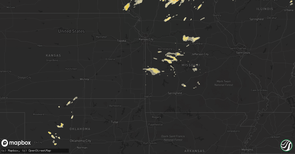
Hail Map in Iowa on June 16, 2012
Get this storm
June 16 map
$229
one time, instant access
Download today. No call, no setup
Keep the $229
Bought the map and want the full workflow? Apply the entire $229 to a subscription within 7 days. None of it is wasted.
Every map, not just this one
This buys you this map. Subscription and you get every map we run, in the markets you choose from a few cities to whole states to nationwide. Plus real-time alerts the moment a storm fires.
Contact data
Name, contact info, occupancy, even credit band for addresses in the footprint. You go from where it hit to who to call.
Become the source they trust
Unlimited branding weather history reports on demand. You already have the documented answer ready for the property owner, and you are the one who showed up with it.
Property data and RoofTrace estimates
Pull up any address you have got, its value and the exact code rules for that jurisdiction, straight from One Click Code. Then RoofTrace estimates the squares, pitch, and roof value, priced the way you price.
Storm reports in Iowa
Iowa
| Date | Description |
|---|---|
| 06/16/20126:35 PM CDT | Reports of trees and power lines down. |
| 06/16/20126:10 PM CDT | Delayed report - time estimated - a house just west of the burlington airport was damaged when half of a tree fell upon the house |
| 06/16/20126:05 PM CDT | Top half of 14 inch diameter tree blown onto street blocking 3 lanes of traffic at 1110 spring street. Time estimated. |
| 06/16/20125:56 PM CDT | 6 inch diamter tree limb broken off of a pair tree. |
| 06/16/20125:56 PM CDT | 6 limb broken off of a pair tree. Time estiamted by radar. |
| 06/16/20125:30 PM CDT | 4 inch tree down and flattened corn. He108 |
| 06/16/20125:26 PM CDT | Ck6 |
| 06/16/20125:18 PM CDT | 6 inch diamter tree limb broken off of a pair tree. Time of event corrected. |
| 06/16/20125:10 PM CDT | Tree fell into house. Time approximate. |
| 06/16/20125:08 PM CDT | Several 3 inch diameter tree limbs down |
| 06/16/20125:00 PM CDT | High winds and trees reported down in richland. |
| 06/16/20124:45 PM CDT | Numerous 4 to 6 inch diameter tree branches down. Estimated 65 mph winds. |
| 06/16/20124:44 PM CDT | Larger than one foot diameter trees down. Light pole down. |
| 06/16/20124:41 PM CDT | Phone lines and tree branches down in the city. |
| 06/16/20124:36 PM CDT | Reports of several trees down in town. |
| 06/16/20124:34 PM CDT | Correction to previous entered lsr with knot to mph conversion error |
| 06/16/20124:32 PM CDT | Measured by idot rwis site near ottumwa along highway 63 |
| 06/16/20124:30 PM CDT | Medium sized tree downed along with numerous other branches. Minor street flooding reported as well. |
| 06/16/20124:28 PM CDT | 3 inch or larger tree branches down. |
| 06/16/20124:20 PM CDT | Numerous 6 inch and larger tree limbs down. Heavy rain. |
| 06/16/20124:00 PM CDT | Trained spotter reports quarter sized hail. Time estimated. |
| 06/16/20123:11 PM CDT | Several 3 to 4 inch branches down across the yard. |
| 06/16/20122:42 PM CDT | Dime and quarter sized hail lasting for about 15 minutes. He82 |
| 06/16/20122:35 PM CDT | Trained spotter reported mostly pea to nickel sized hail with a few quarters. Time estimated. |
| 06/16/20122:35 PM CDT | Trained spotter reports mostly pea to nickel sized hail with some quarters mixed in. Time estimated. |
| 06/16/20122:04 PM CDT | Time estimated from radar. |
All States Impacted by Hail Map on June 16, 2012
Cities Impacted by Hail Map on June 16, 2012
- Electra, TX
- Davidson, OK
- Oklaunion, TX
- Harrold, TX
- Lincoln, MO
- Cole Camp, MO
- Merrillville, IN
- Crown Point, IN
- Fayette, MO
- Abingdon, IL
- Gilson, IL
- Knoxville, IL
- London Mills, IL
- Maquon, IL
- Saint Augustine, IL
- Saunemin, IL
- Altona, IL
- Thomas, OK
- Weatherford, OK
- Lowell, IN
- Henryville, IN
- Memphis, IN
- Galesburg, IL
- Bucklin, MO
- New Cambria, MO
- Harrisburg, MO
- Hallsville, MO
- Columbia, MO
- Sturgeon, MO
- Metamora, IL
- Lowpoint, IL
- New Buffalo, MI
- Wetmore, CO
- Smithton, MO
- Stockport, IA
- Milton, IA
- Memphis, MO
- Cantril, IA
- Keosauqua, IA
- Birmingham, IA
- Douds, IA
- Blackstone, IL
- Pritchett, CO
- West Point, IA
- Saint Paul, IA
- East Galesburg, IL
- Hereford, TX
- Fowler, CO
- Avondale, CO
- Mount Ayr, IA
- Redding, IA
- Essex, IL
- Humansville, MO
- Haskell, TX
- Weinert, TX
- Meadow, TX
- Wilson, TX
- Tahoka, TX
- Covington, IN
- Veedersburg, IN
- West Lebanon, IN
- Williamsport, IN
- Attica, IN
- Sugar City, CO
- Bloomfield, IA
- Hamlin, TX
- Caldwell, KS
- Sardinia, OH
- Mount Orab, OH
- Princeton, MO
- Yoder, CO
- Mora, MO
- Sedalia, MO
- Mooresville, MO
- Utica, MO
- Chillicothe, MO
- Okeene, OK
- El Dorado Springs, MO
- Walker, MO
- Schell City, MO
- Harwood, MO
- Rockville, MO
- Richards, MO
- Rich Hill, MO
- Cotopaxi, CO
- Loveland, OK
- Wakita, OK
- Canyon, TX
- Maryville, MO
- Kellerton, IA
- Wilmington, IL
- Reddick, IL
- Bonfield, IL
- Gardner, IL
- Gowen, MI
- Lakeview, MI
- Stanton, MI
- Trufant, MI
- Seymour, TX
- Goree, TX
- Coatsville, MO
- Glenwood, MO
- Moulton, IA
- Gladstone, IL
- Stronghurst, IL
- Kankakee, IL
- Chebanse, IL
- Winchester, OH
- Hurdland, MO
- Baring, MO
- Edina, MO
- Hoopeston, IL
- Dwight, IL
- Milton, IN
- Cambridge City, IN
- Connersville, IN
- Pueblo, CO
- Friona, TX
- Conchas Dam, NM
- Kent City, MI
- Eagleville, MO
- Davis City, IA
- Cainsville, MO
- Blythedale, MO
- Clinton, MO
- Maysville, KY
- Raton, NM
- Colony, OK
- Hydro, OK
- Nash, OK
- Georgetown, OH
- Russellville, OH
- Franklin, MO
- Glasgow, MO
- Cedar Lake, IN
- Albia, IA
- Moravia, IA
- Ambia, IN
- Fowler, IN
- Sand Lake, MI
- Pierson, MI
- Aspermont, TX
- Blakesburg, IA
- Shepherd, TX
- Hebron, IN
- Whitesboro, TX
- Gordonville, TX
- Tucson, AZ
- Grand River, IA
- Van Wert, IA
- Unionville, MO
- Pollock, MO
- Lucerne, MO
- Powersville, MO
- Portales, NM
- Brimfield, IL
- Elmwood, IL
- Williamsfield, IL
- Laura, IL
- Niangua, MO
- Conway, MO
- Oneida, IL
- Enid, OK
- Waukomis, OK
- Benton, IA
- New Franklin, MO
- Gilliam, MO
- Slater, MO
- Rocheport, MO
- Centralia, MO
- Mercer, MO
- Newtown, MO
- Dimmitt, TX
- Paducah, TX
- Old Glory, TX
- Warsaw, MO
- Tuscumbia, MO
- Saint Elizabeth, MO
- O'Brien, TX
- Merkel, TX
- Floyd, NM
- Yates City, IL
- Farmington, IL
- Hermitage, MO
- Pittsburg, MO
- Forrest, IL
- Cullom, IL
- Fairbury, IL
- Custer City, OK
- Ropesville, TX
- Milford, IL
- Cissna Park, IL
- Onarga, IL
- Loda, IL
- Buckley, IL
- Brownfield, TX
- Rensselaer, IN
- Bedford, IA
- Vega, TX
- Floris, IA
- Pulaski, IA
- Moscow, TX
- Blockton, IA
- Pickering, MO
- Parnell, MO
- Hopkins, MO
- Sheridan, MO
- Happy, TX
- Springfield, CO
- Crowell, TX
- Lamoni, IA
- Redkey, IN
- Ridgeville, IN
- Albany, IN
- Parker City, IN
- Downing, WI
- Glenwood City, WI
- Boyceville, WI
- Queen City, MO
- Livonia, MO
- Summerfield, TX
- Cameron, IL
- Avon, IL
- Berwick, IL
- Wataga, IL
- Walters, OK
- Rulo, NE
- Geary, OK
- Mosquero, NM
- Chanute, KS
- Downing, MO
- Windsor, MO
- Green Valley, AZ
- Calhoun, MO
- Rossville, IL
- Tarkio, MO
- Cache, OK
- Peoria, IL
- Dunlap, IL
- Edwards, IL
- Mapleton, IL
- Faxon, OK
- Iberia, MO
- Chattanooga, OK
- Grandfield, OK
- Florence, MO
- Stover, MO
- Versailles, MO
- Leeton, MO
- Green Ridge, MO
- Fortuna, MO
- Colorado City, CO
- Rye, CO
- Beulah, CO
- Garita, NM
- Jamestown, OH
- Port William, OH
- Wilmington, OH
- Ionia, MO
- Deepwater, MO
- Schneider, IN
- Momence, IL
- Grant Park, IL
- Lake Village, IN
- Pembroke Township, IL
- Leon, IA
- Ridgeway, MO
- Falls City, NE
- Fairfax, MO
- Craig, MO
- Kim, CO
- Medaryville, IN
- Francesville, IN
- Hillsboro, OH
- Washburn, IL
- Watonga, OK
- Lomax, IL
- Arlington, CO
- Greentop, MO
- Black River Falls, WI
- Hume, MO
- Prescott, KS
- Fulton, KS
- Nevada, MO
- Agency, IA
- Ottumwa, IA
- Lawton, OK
- Mountain View, OK
- Carnegie, OK
- Apache, OK
- Princeville, IL
- Hoffman Estates, IL
- Streamwood, IL
- Hanover Park, IL
- Schaumburg, IL
- Seymour, IA
- Manito, IL
- Brashear, MO
- Marshfield, MO
- Ludlow, IL
- Paxton, IL
- Fairview, IL
- Bailey, CO
- La Porte, IN
- Michigan City, IN
- Boswell, IN
- Perrysville, IN
- Alvin, IL
- Mountain Grove, MO
- Swan River, MN
- Westcliffe, CO
- Maxwell, NM
- Springer, NM
- Dickens, TX
- Avery, TX
- Peotone, IL
- Manhattan, IL
- Lubbock, TX
- Munday, TX
- Otterville, MO
- Dixon, MO
- Dahinda, IL
- Fairborn, OH
- Yellow Springs, OH
- Mound City, MO
- Rule, TX
- Media, IL
- Carman, IL
- Raritan, IL
- Burlington, IA
- Biggsville, IL
- Medford, OK
- Aroma Park, IL
- Herscher, IL
- Clifton, IL
- Bradley, IL
- Saint Anne, IL
- Bourbonnais, IL
- Sidney, OH
- Rochester, TX
- Groveton, TX
- Kirksville, MO
- Corydon, IA
- Butler, MO
- Skidmore, MO
- Mount Pleasant, IA
- Hillsboro, IA
- New London, IA
- Salem, IA
- Selma, IA
- Ludlow, MO
- Denver City, TX
- Seagraves, TX
- Syracuse, MO
- Vernon, TX
- Hillsboro, IN
- Newtown, IN
- Mellott, IN
- Henning, IL
- Waynetown, IN
- Glenview, IL
- Northbrook, IL
- Monmouth, IL
- Alexis, IL
- Gerlaw, IL
- Trivoli, IL
- Enon, OH
- Bunceton, MO
- Boonville, MO
- Cherokee, OK
- Springfield, OH
- Pecos, TX
- Wallingford, KY
- Flemingsburg, KY
- Harris, MO
- Green City, MO
- Spickard, MO
- Two Buttes, CO
- Milan, MO
- Melrose, NM
- Mcadoo, TX
- Kewanna, IN
- Muleshoe, TX
- Martinsville, OH
- Lynchburg, OH
- New Vienna, OH
- Centerville, IA
- Abilene, TX
- Mount Prospect, IL
- Prospect Heights, IL
- Barnett, MO
- Rocky Mount, MO
- Eldon, MO
- Louisville, NE
- Springfield, NE
- South Bend, NE
- Ashland, NE
- Gretna, NE
- Champaign, IL
- Danville, IA
- Grenville, NM
- Rutledge, MO
- Novelty, MO
- Union Pier, MI
- Dyer, IN
- Crete, IL
- Chicago Heights, IL
- Lineville, IA
- Brumley, MO
- Hartville, MO
- Cedar Springs, MI
- Coral, MI
- Greenville, MI
- Ellston, IA
- Kirkwood, IL
- Centerview, MO
- Holden, MO
- Sahuarita, AZ
- Newburg, MO
- Tulia, TX
- Luray, MO
- Corn, OK
- Osceola, MO
- Shelbyville, MO
- Lentner, MO
- Rolling Meadows, IL
- Arlington Heights, IL
- Wheatland, MO
- Cross Timbers, MO
- Linneus, MO
- Purdin, MO
- Decatur, IA
- Arbela, MO
- Sabina, OH
- Leesburg, OH
- Walsh, CO
- Ocate, NM
- Valparaiso, IN
- Allerton, IA
- Dunkirk, IN
- Farmland, IN
- Hitchcock, OK
- Newkirk, NM
- Monon, IN
- McCaulley, TX
- Sonoita, AZ
- Patagonia, AZ
- Ancona, IL
- South Bend, IN
- Lakeville, IN
- Verdigre, NE
- Buchanan, MI
- Galien, MI
- Tucumcari, NM
- Ashkum, IL
- Amarillo, TX
- Goodland, IN
- Brook, IN
- Trenton, MO
- Green Castle, MO
- Exline, IA
- Maitland, MO
- Gifford, IL
- Rantoul, IL
- Earl Park, IN
- Sheldon, IL
- Rio, IL
- Manteno, IL
- Cabery, IL
- Martinton, IL
- Danforth, IL
- Emington, IL
- Campus, IL
- Buckingham, IL
- Bonaparte, IA
- Hale Center, TX
- Oak Creek, WI
- Racine, WI
- Caledonia, WI
- Bevier, MO
- Macon, MO
- Tioga, TX
- Streator, IL
- Wenona, IL
- Long Point, IL
- Dana, IL
- Mindenmines, MO
- West Liberty, KY
- Donnellson, IA
- Crocker, MO
- Richland, MO
- Canton, OK
- Quincy, OH
- Maplewood, OH
- Unionville, IA
- Murdock, NE
- Glasford, IL
- Hedrick, IA
- Ethel, MO
- Talihina, OK
- Gary, IN
- Plainview, TX
- Conifer, CO
- Chula, MO
- Falcon, MO
- Plato, MO
- Beecher, IL
- Macomb, IL
- Wheeling, MO
- Cincinnati, IA
- Seymour, IN
- Ulman, MO
- Winfield, IA
- Mount Union, IA
- Morning Sun, IA
- Erie, KS
- Galesburg, KS
- Hope, IN
- Medway, OH
- Brookville, IN
- Roseville, IL
- Gorin, MO
- Knox City, TX
- Jet, OK
- Elkland, MO
- Ravenwood, MO
- Burlington Junction, MO
- Montpelier, IA
- Blue Grass, IA
- Muscatine, IA
- Sweet Springs, MO
- Farwell, TX
- Hanna City, IL
- Clearmont, MO
- Midland, OH
- Bolivar, MO
- Polk, MO
- Las Animas, CO
- Varna, IL
- East Peoria, IL
- Lacon, IL
- Blanchester, OH
- Manzanola, CO
- Mayslick, KY
- North Henderson, IL
- Hinton, OK
- Wyoming, IL
- Quincy, MO
- Glencoe, NM
- Ruidoso, NM
- Sylvester, TX
- Breckenridge, MO
- Bainbridge, OH
- Greenfield, OH
- Canon City, CO
- Toluca, IL
- Kremlin, OK
- Mcgregor, MN
- Atoka, OK


