Hail Map in Illinois on June 16, 2012
Get this storm
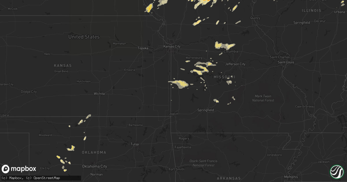
June 16 map
$229
one time, instant access
Download today. No call, no setup
Keep the $229
Bought the map and want the full workflow? Apply the entire $229 to a subscription within 7 days. None of it is wasted.
Every map, not just this one
This buys you this map. Subscription and you get every map we run, in the markets you choose from a few cities to whole states to nationwide. Plus real-time alerts the moment a storm fires.
Contact data
Name, contact info, occupancy, even credit band for addresses in the footprint. You go from where it hit to who to call.
Become the source they trust
Unlimited branding weather history reports on demand. You already have the documented answer ready for the property owner, and you are the one who showed up with it.
Property data and RoofTrace estimates
Pull up any address you have got, its value and the exact code rules for that jurisdiction, straight from One Click Code. Then RoofTrace estimates the squares, pitch, and roof value, priced the way you price.
Storm reports in Illinois
Illinois
| Date | Description |
|---|---|
| 06/16/20126:48 PM CDT | Several machine sheds and wooden structures...2 metal and 1 concrete grain bin heavily damaged. 2 power poles snapped. Damage extended from 3 miles southwest to 3 miles |
| 06/16/20126:45 PM CDT | Several small tree limbs down on road. |
| 06/16/20126:43 PM CDT | A local report indicates 1.50 inch wind near 2 S GALESBURG |
| 06/16/20126:40 PM CDT | Multiple trees and power lines down. |
| 06/16/20126:40 PM CDT | Multiple trees and power lines down. |
| 06/16/20126:35 PM CDT | Reports of trees and power lines down. Corrected location. |
| 06/16/20126:30 PM CDT | Reports of trees and power lines down. |
| 06/16/20125:05 PM CDT | Several minutes of pea sized hail also reported. |
| 06/16/201212:15 PM CDT | Several trees blown down. A school lost part of its roof. Report from wfo chicago storm spotter. |
| 06/16/20127:30 AM CDT | 3 foot diameter tree down |
| 06/15/20128:31 PM CDT | A local report indicates 65 MPH wind near TREMONT |
| 06/15/20128:10 PM CDT | 4-6 inch limbs at market st area |
| 06/15/20127:45 PM CDT | Branches across roads. Street flooding. |
| 06/15/20127:33 PM CDT | A local report indicates 1.50 inch wind near 5 E KNOXVILLE |
| 06/15/20127:30 PM CDT | 3 foot diameter tree down |
| 06/15/20127:20 PM CDT | 1 foot diameter branch down at river rd. Also street flooding |
| 06/15/20127:15 PM CDT | A local report indicates 58 MPH wind near 2 NE PITTSFIELD |
| 06/15/20127:10 PM CDT | Limbs down throughout town with damage to a vehicle due to flying plywood...also trees down blocking the road in perry and pleasant hill |
| 06/15/20127:08 PM CDT | A local report indicates 1.00 inch wind near ALTONA |
| 06/15/20127:01 PM CDT | Corn stalks flattened. Time estiamted from radar. |
All States Impacted by Hail Map on June 16, 2012
Cities Impacted by Hail Map on June 16, 2012
- Electra, TX
- Davidson, OK
- Oklaunion, TX
- Harrold, TX
- Lincoln, MO
- Cole Camp, MO
- Merrillville, IN
- Crown Point, IN
- Fayette, MO
- Abingdon, IL
- Gilson, IL
- Knoxville, IL
- London Mills, IL
- Maquon, IL
- Saint Augustine, IL
- Saunemin, IL
- Altona, IL
- Thomas, OK
- Weatherford, OK
- Lowell, IN
- Henryville, IN
- Memphis, IN
- Galesburg, IL
- Bucklin, MO
- New Cambria, MO
- Harrisburg, MO
- Hallsville, MO
- Columbia, MO
- Sturgeon, MO
- Metamora, IL
- Lowpoint, IL
- New Buffalo, MI
- Wetmore, CO
- Smithton, MO
- Stockport, IA
- Milton, IA
- Memphis, MO
- Cantril, IA
- Keosauqua, IA
- Birmingham, IA
- Douds, IA
- Blackstone, IL
- Pritchett, CO
- West Point, IA
- Saint Paul, IA
- East Galesburg, IL
- Hereford, TX
- Fowler, CO
- Avondale, CO
- Mount Ayr, IA
- Redding, IA
- Essex, IL
- Humansville, MO
- Haskell, TX
- Weinert, TX
- Meadow, TX
- Wilson, TX
- Tahoka, TX
- Covington, IN
- Veedersburg, IN
- West Lebanon, IN
- Williamsport, IN
- Attica, IN
- Sugar City, CO
- Bloomfield, IA
- Hamlin, TX
- Caldwell, KS
- Sardinia, OH
- Mount Orab, OH
- Princeton, MO
- Yoder, CO
- Mora, MO
- Sedalia, MO
- Mooresville, MO
- Utica, MO
- Chillicothe, MO
- Okeene, OK
- El Dorado Springs, MO
- Walker, MO
- Schell City, MO
- Harwood, MO
- Rockville, MO
- Richards, MO
- Rich Hill, MO
- Cotopaxi, CO
- Loveland, OK
- Wakita, OK
- Canyon, TX
- Maryville, MO
- Kellerton, IA
- Wilmington, IL
- Reddick, IL
- Bonfield, IL
- Gardner, IL
- Gowen, MI
- Lakeview, MI
- Stanton, MI
- Trufant, MI
- Seymour, TX
- Goree, TX
- Coatsville, MO
- Glenwood, MO
- Moulton, IA
- Gladstone, IL
- Stronghurst, IL
- Kankakee, IL
- Chebanse, IL
- Winchester, OH
- Hurdland, MO
- Baring, MO
- Edina, MO
- Hoopeston, IL
- Dwight, IL
- Milton, IN
- Cambridge City, IN
- Connersville, IN
- Pueblo, CO
- Friona, TX
- Conchas Dam, NM
- Kent City, MI
- Eagleville, MO
- Davis City, IA
- Cainsville, MO
- Blythedale, MO
- Clinton, MO
- Maysville, KY
- Raton, NM
- Colony, OK
- Hydro, OK
- Nash, OK
- Georgetown, OH
- Russellville, OH
- Franklin, MO
- Glasgow, MO
- Cedar Lake, IN
- Albia, IA
- Moravia, IA
- Ambia, IN
- Fowler, IN
- Sand Lake, MI
- Pierson, MI
- Aspermont, TX
- Blakesburg, IA
- Shepherd, TX
- Hebron, IN
- Whitesboro, TX
- Gordonville, TX
- Tucson, AZ
- Grand River, IA
- Van Wert, IA
- Unionville, MO
- Pollock, MO
- Lucerne, MO
- Powersville, MO
- Portales, NM
- Brimfield, IL
- Elmwood, IL
- Williamsfield, IL
- Laura, IL
- Niangua, MO
- Conway, MO
- Oneida, IL
- Enid, OK
- Waukomis, OK
- Benton, IA
- New Franklin, MO
- Gilliam, MO
- Slater, MO
- Rocheport, MO
- Centralia, MO
- Mercer, MO
- Newtown, MO
- Dimmitt, TX
- Paducah, TX
- Old Glory, TX
- Warsaw, MO
- Tuscumbia, MO
- Saint Elizabeth, MO
- O'Brien, TX
- Merkel, TX
- Floyd, NM
- Yates City, IL
- Farmington, IL
- Hermitage, MO
- Pittsburg, MO
- Forrest, IL
- Cullom, IL
- Fairbury, IL
- Custer City, OK
- Ropesville, TX
- Milford, IL
- Cissna Park, IL
- Onarga, IL
- Loda, IL
- Buckley, IL
- Brownfield, TX
- Rensselaer, IN
- Bedford, IA
- Vega, TX
- Floris, IA
- Pulaski, IA
- Moscow, TX
- Blockton, IA
- Pickering, MO
- Parnell, MO
- Hopkins, MO
- Sheridan, MO
- Happy, TX
- Springfield, CO
- Crowell, TX
- Lamoni, IA
- Redkey, IN
- Ridgeville, IN
- Albany, IN
- Parker City, IN
- Downing, WI
- Glenwood City, WI
- Boyceville, WI
- Queen City, MO
- Livonia, MO
- Summerfield, TX
- Cameron, IL
- Avon, IL
- Berwick, IL
- Wataga, IL
- Walters, OK
- Rulo, NE
- Geary, OK
- Mosquero, NM
- Chanute, KS
- Downing, MO
- Windsor, MO
- Green Valley, AZ
- Calhoun, MO
- Rossville, IL
- Tarkio, MO
- Cache, OK
- Peoria, IL
- Dunlap, IL
- Edwards, IL
- Mapleton, IL
- Faxon, OK
- Iberia, MO
- Chattanooga, OK
- Grandfield, OK
- Florence, MO
- Stover, MO
- Versailles, MO
- Leeton, MO
- Green Ridge, MO
- Fortuna, MO
- Colorado City, CO
- Rye, CO
- Beulah, CO
- Garita, NM
- Jamestown, OH
- Port William, OH
- Wilmington, OH
- Ionia, MO
- Deepwater, MO
- Schneider, IN
- Momence, IL
- Grant Park, IL
- Lake Village, IN
- Pembroke Township, IL
- Leon, IA
- Ridgeway, MO
- Falls City, NE
- Fairfax, MO
- Craig, MO
- Kim, CO
- Medaryville, IN
- Francesville, IN
- Hillsboro, OH
- Washburn, IL
- Watonga, OK
- Lomax, IL
- Arlington, CO
- Greentop, MO
- Black River Falls, WI
- Hume, MO
- Prescott, KS
- Fulton, KS
- Nevada, MO
- Agency, IA
- Ottumwa, IA
- Lawton, OK
- Mountain View, OK
- Carnegie, OK
- Apache, OK
- Princeville, IL
- Hoffman Estates, IL
- Streamwood, IL
- Hanover Park, IL
- Schaumburg, IL
- Seymour, IA
- Manito, IL
- Brashear, MO
- Marshfield, MO
- Ludlow, IL
- Paxton, IL
- Fairview, IL
- Bailey, CO
- La Porte, IN
- Michigan City, IN
- Boswell, IN
- Perrysville, IN
- Alvin, IL
- Mountain Grove, MO
- Swan River, MN
- Westcliffe, CO
- Maxwell, NM
- Springer, NM
- Dickens, TX
- Avery, TX
- Peotone, IL
- Manhattan, IL
- Lubbock, TX
- Munday, TX
- Otterville, MO
- Dixon, MO
- Dahinda, IL
- Fairborn, OH
- Yellow Springs, OH
- Mound City, MO
- Rule, TX
- Media, IL
- Carman, IL
- Raritan, IL
- Burlington, IA
- Biggsville, IL
- Medford, OK
- Aroma Park, IL
- Herscher, IL
- Clifton, IL
- Bradley, IL
- Saint Anne, IL
- Bourbonnais, IL
- Sidney, OH
- Rochester, TX
- Groveton, TX
- Kirksville, MO
- Corydon, IA
- Butler, MO
- Skidmore, MO
- Mount Pleasant, IA
- Hillsboro, IA
- New London, IA
- Salem, IA
- Selma, IA
- Ludlow, MO
- Denver City, TX
- Seagraves, TX
- Syracuse, MO
- Vernon, TX
- Hillsboro, IN
- Newtown, IN
- Mellott, IN
- Henning, IL
- Waynetown, IN
- Glenview, IL
- Northbrook, IL
- Monmouth, IL
- Alexis, IL
- Gerlaw, IL
- Trivoli, IL
- Enon, OH
- Bunceton, MO
- Boonville, MO
- Cherokee, OK
- Springfield, OH
- Pecos, TX
- Wallingford, KY
- Flemingsburg, KY
- Harris, MO
- Green City, MO
- Spickard, MO
- Two Buttes, CO
- Milan, MO
- Melrose, NM
- Mcadoo, TX
- Kewanna, IN
- Muleshoe, TX
- Martinsville, OH
- Lynchburg, OH
- New Vienna, OH
- Centerville, IA
- Abilene, TX
- Mount Prospect, IL
- Prospect Heights, IL
- Barnett, MO
- Rocky Mount, MO
- Eldon, MO
- Louisville, NE
- Springfield, NE
- South Bend, NE
- Ashland, NE
- Gretna, NE
- Champaign, IL
- Danville, IA
- Grenville, NM
- Rutledge, MO
- Novelty, MO
- Union Pier, MI
- Dyer, IN
- Crete, IL
- Chicago Heights, IL
- Lineville, IA
- Brumley, MO
- Hartville, MO
- Cedar Springs, MI
- Coral, MI
- Greenville, MI
- Ellston, IA
- Kirkwood, IL
- Centerview, MO
- Holden, MO
- Sahuarita, AZ
- Newburg, MO
- Tulia, TX
- Luray, MO
- Corn, OK
- Osceola, MO
- Shelbyville, MO
- Lentner, MO
- Rolling Meadows, IL
- Arlington Heights, IL
- Wheatland, MO
- Cross Timbers, MO
- Linneus, MO
- Purdin, MO
- Decatur, IA
- Arbela, MO
- Sabina, OH
- Leesburg, OH
- Walsh, CO
- Ocate, NM
- Valparaiso, IN
- Allerton, IA
- Dunkirk, IN
- Farmland, IN
- Hitchcock, OK
- Newkirk, NM
- Monon, IN
- McCaulley, TX
- Sonoita, AZ
- Patagonia, AZ
- Ancona, IL
- South Bend, IN
- Lakeville, IN
- Verdigre, NE
- Buchanan, MI
- Galien, MI
- Tucumcari, NM
- Ashkum, IL
- Amarillo, TX
- Goodland, IN
- Brook, IN
- Trenton, MO
- Green Castle, MO
- Exline, IA
- Maitland, MO
- Gifford, IL
- Rantoul, IL
- Earl Park, IN
- Sheldon, IL
- Rio, IL
- Manteno, IL
- Cabery, IL
- Martinton, IL
- Danforth, IL
- Emington, IL
- Campus, IL
- Buckingham, IL
- Bonaparte, IA
- Hale Center, TX
- Oak Creek, WI
- Racine, WI
- Caledonia, WI
- Bevier, MO
- Macon, MO
- Tioga, TX
- Streator, IL
- Wenona, IL
- Long Point, IL
- Dana, IL
- Mindenmines, MO
- West Liberty, KY
- Donnellson, IA
- Crocker, MO
- Richland, MO
- Canton, OK
- Quincy, OH
- Maplewood, OH
- Unionville, IA
- Murdock, NE
- Glasford, IL
- Hedrick, IA
- Ethel, MO
- Talihina, OK
- Gary, IN
- Plainview, TX
- Conifer, CO
- Chula, MO
- Falcon, MO
- Plato, MO
- Beecher, IL
- Macomb, IL
- Wheeling, MO
- Cincinnati, IA
- Seymour, IN
- Ulman, MO
- Winfield, IA
- Mount Union, IA
- Morning Sun, IA
- Erie, KS
- Galesburg, KS
- Hope, IN
- Medway, OH
- Brookville, IN
- Roseville, IL
- Gorin, MO
- Knox City, TX
- Jet, OK
- Elkland, MO
- Ravenwood, MO
- Burlington Junction, MO
- Montpelier, IA
- Blue Grass, IA
- Muscatine, IA
- Sweet Springs, MO
- Farwell, TX
- Hanna City, IL
- Clearmont, MO
- Midland, OH
- Bolivar, MO
- Polk, MO
- Las Animas, CO
- Varna, IL
- East Peoria, IL
- Lacon, IL
- Blanchester, OH
- Manzanola, CO
- Mayslick, KY
- North Henderson, IL
- Hinton, OK
- Wyoming, IL
- Quincy, MO
- Glencoe, NM
- Ruidoso, NM
- Sylvester, TX
- Breckenridge, MO
- Bainbridge, OH
- Greenfield, OH
- Canon City, CO
- Toluca, IL
- Kremlin, OK
- Mcgregor, MN
- Atoka, OK


