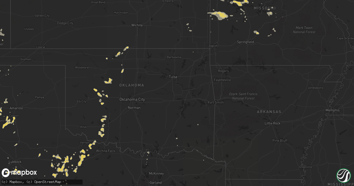
Hail Map on June 16, 2012
Get this storm
June 16 map
$229
one time, instant access
Download today. No call, no setup
Keep the $229
Bought the map and want the full workflow? Apply the entire $229 to a subscription within 7 days. None of it is wasted.
Every map, not just this one
This buys you this map. Subscription and you get every map we run, in the markets you choose from a few cities to whole states to nationwide. Plus real-time alerts the moment a storm fires.
Contact data
Name, contact info, occupancy, even credit band for addresses in the footprint. You go from where it hit to who to call.
Become the source they trust
Unlimited branding weather history reports on demand. You already have the documented answer ready for the property owner, and you are the one who showed up with it.
Property data and RoofTrace estimates
Pull up any address you have got, its value and the exact code rules for that jurisdiction, straight from One Click Code. Then RoofTrace estimates the squares, pitch, and roof value, priced the way you price.
States Impacted by Hail Map on June 16, 2012
Storm reports
Oklahoma
| Date | Description |
|---|---|
| 06/16/20124:21 PM CDT | A local report indicates 1.00 inch wind near 5 S CACHE |
Illinois
| Date | Description |
|---|---|
| 06/16/20126:48 PM CDT | Several machine sheds and wooden structures...2 metal and 1 concrete grain bin heavily damaged. 2 power poles snapped. Damage extended from 3 miles southwest to 3 miles |
| 06/16/20126:45 PM CDT | Several small tree limbs down on road. |
| 06/16/20126:43 PM CDT | A local report indicates 1.50 inch wind near 2 S GALESBURG |
| 06/16/20126:40 PM CDT | Multiple trees and power lines down. |
| 06/16/20126:40 PM CDT | Multiple trees and power lines down. |
| 06/16/20126:35 PM CDT | Reports of trees and power lines down. Corrected location. |
| 06/16/20126:30 PM CDT | Reports of trees and power lines down. |
| 06/16/20125:05 PM CDT | Several minutes of pea sized hail also reported. |
| 06/16/201212:15 PM CDT | Several trees blown down. A school lost part of its roof. Report from wfo chicago storm spotter. |
| 06/16/20127:30 AM CDT | 3 foot diameter tree down |
| 06/15/20128:31 PM CDT | A local report indicates 65 MPH wind near TREMONT |
| 06/15/20128:10 PM CDT | 4-6 inch limbs at market st area |
| 06/15/20127:45 PM CDT | Branches across roads. Street flooding. |
| 06/15/20127:33 PM CDT | A local report indicates 1.50 inch wind near 5 E KNOXVILLE |
| 06/15/20127:30 PM CDT | 3 foot diameter tree down |
| 06/15/20127:20 PM CDT | 1 foot diameter branch down at river rd. Also street flooding |
| 06/15/20127:15 PM CDT | A local report indicates 58 MPH wind near 2 NE PITTSFIELD |
| 06/15/20127:10 PM CDT | Limbs down throughout town with damage to a vehicle due to flying plywood...also trees down blocking the road in perry and pleasant hill |
| 06/15/20127:08 PM CDT | A local report indicates 1.00 inch wind near ALTONA |
| 06/15/20127:01 PM CDT | Corn stalks flattened. Time estiamted from radar. |
Iowa
| Date | Description |
|---|---|
| 06/16/20126:35 PM CDT | Reports of trees and power lines down. |
| 06/16/20126:10 PM CDT | Delayed report - time estimated - a house just west of the burlington airport was damaged when half of a tree fell upon the house |
| 06/16/20126:05 PM CDT | Top half of 14 inch diameter tree blown onto street blocking 3 lanes of traffic at 1110 spring street. Time estimated. |
| 06/16/20125:56 PM CDT | 6 inch diamter tree limb broken off of a pair tree. |
| 06/16/20125:56 PM CDT | 6 limb broken off of a pair tree. Time estiamted by radar. |
| 06/16/20125:30 PM CDT | 4 inch tree down and flattened corn. He108 |
| 06/16/20125:26 PM CDT | Ck6 |
| 06/16/20125:18 PM CDT | 6 inch diamter tree limb broken off of a pair tree. Time of event corrected. |
| 06/16/20125:10 PM CDT | Tree fell into house. Time approximate. |
| 06/16/20125:08 PM CDT | Several 3 inch diameter tree limbs down |
| 06/16/20125:00 PM CDT | High winds and trees reported down in richland. |
| 06/16/20124:45 PM CDT | Numerous 4 to 6 inch diameter tree branches down. Estimated 65 mph winds. |
| 06/16/20124:44 PM CDT | Larger than one foot diameter trees down. Light pole down. |
| 06/16/20124:41 PM CDT | Phone lines and tree branches down in the city. |
| 06/16/20124:36 PM CDT | Reports of several trees down in town. |
| 06/16/20124:34 PM CDT | Correction to previous entered lsr with knot to mph conversion error |
| 06/16/20124:32 PM CDT | Measured by idot rwis site near ottumwa along highway 63 |
| 06/16/20124:30 PM CDT | Medium sized tree downed along with numerous other branches. Minor street flooding reported as well. |
| 06/16/20124:28 PM CDT | 3 inch or larger tree branches down. |
| 06/16/20124:20 PM CDT | Numerous 6 inch and larger tree limbs down. Heavy rain. |
| 06/16/20124:00 PM CDT | Trained spotter reports quarter sized hail. Time estimated. |
| 06/16/20123:11 PM CDT | Several 3 to 4 inch branches down across the yard. |
| 06/16/20122:42 PM CDT | Dime and quarter sized hail lasting for about 15 minutes. He82 |
| 06/16/20122:35 PM CDT | Trained spotter reports mostly pea to nickel sized hail with some quarters mixed in. Time estimated. |
| 06/16/20122:35 PM CDT | Trained spotter reported mostly pea to nickel sized hail with a few quarters. Time estimated. |
| 06/16/20122:04 PM CDT | Time estimated from radar. |
Wisconsin
| Date | Description |
|---|---|
| 06/16/20126:53 PM CDT | Several trees and powerlines down in the city. |
| 06/15/20128:40 PM CDT | Tree down on north side of la crosse. |
| 06/15/20128:40 PM CDT | Branches and powerlines down at pettibone park. Also a road sign blown into highway. |
Arizona
| Date | Description |
|---|---|
| 06/16/20125:42 PM CDT | Spotter reports tree limbs down. 0.75 mile west of twin peaks exit. |
Colorado
| Date | Description |
|---|---|
| 06/16/20124:49 PM CDT | A local report indicates 1.00 inch wind near 1 WNW COLORADO CITY |
| 06/16/20123:05 PM CDT | A local report indicates 1.50 inch wind near 5 NE HILLSIDE |
| 06/16/20122:51 PM CDT | A local report indicates 1.00 inch wind near 5 NE HILLSIDE |
Kentucky
| Date | Description |
|---|---|
| 06/16/20124:06 PM CDT | 1 mile south of orangeburg hail covering the ground. Hail lasted approximately 1/2 hour. |
New Mexico
| Date | Description |
|---|---|
| 06/16/20121:56 PM CDT | A local report indicates 1.00 inch wind near RUIDOSO DOWNS |
| 06/15/20128:05 PM CDT | Power has been out since around 650 or 7 pm mdt. |
| 06/15/20127:47 PM CDT | A local report indicates 60 MPH wind near 2 W LOGAN |
Missouri
| Date | Description |
|---|---|
| 06/16/20124:57 PM CDT | Large tree down across noland rd in fayette. |
| 06/16/20124:01 PM CDT | Delyaed report. Several 4 to 6 inch tree limbs down near the northern city limits. |
| 06/16/20124:01 PM CDT | A local report indicates 1.75 inch wind near 2 NE CHILLICOTHE |
| 06/16/20124:01 PM CDT | Corrected location to 2 nw of chillicothe. |
| 06/16/20123:57 PM CDT | Quarter size hail and 50 mph winds. |
| 06/16/20123:34 PM CDT | Fire dept reports golf ball size hail 5.5 miles west of unionville on rt u/iowa line. Fire chief reported seeing some rotation lasted 2-3 minutes and dissipated. Also r |
| 06/16/20123:15 PM CDT | Quarter to golf ball sized hail |
| 06/16/20123:05 PM CDT | A local report indicates 1.50 inch wind near LUCERNE |
| 06/16/20121:59 PM CDT | Trees reported down along state highway ab...time unknown |
| 06/16/20121:49 PM CDT | A local report indicates 58 MPH wind near MARYVILLE |
| 06/16/20121:19 AM CDT | A local report indicates 1.00 inch wind near 15 WSW OSCEOLA |
| 06/16/201212:20 AM CDT | A local report indicates 1.00 inch wind near 15 WSW OSCEOLA |
| 06/15/201210:50 PM CDT | Power lines blown down. |
| 06/15/201210:50 PM CDT | Trees down in crocker on highway 133. |
| 06/15/201210:32 PM CDT | Public reports trees and power lines down on highway 133 west of dixon. |
| 06/15/20127:21 PM CDT | West central columbia on braemore rd...24 to 30 inch diameter tree fell onto a house. Retractable awning snapped in half. 30 ft tall tree onto roof of house. |
Indiana
| Date | Description |
|---|---|
| 06/16/20126:32 PM CDT | Few trees down in town. |
| 06/16/20126:00 PM CDT | Local media reported a large trees was blown down by strong winds across county road 68...blocking traffic. |
| 06/16/20125:40 PM CDT | A local report indicates 60 MPH wind near 2 SE HENRYVILLE |
| 06/16/20125:30 PM CDT | Large tree limb down |
| 06/16/20125:28 PM CDT | Broadcast media relayed a report of an outdoor storage building that was thrown into a neighbors yard in henryville. |
| 06/16/20124:30 PM CDT | Report from town of rob roy. Tree limbs approx 1 inch in diameter blown down. Power outage delayed report. |
| 06/16/20123:48 PM CDT | Tree and branches down. Street blocked |
| 06/16/20123:47 PM CDT | Tree down and large branches blocking road. |
| 06/16/20123:46 PM CDT | Trees down - blocking road |
| 06/16/20123:46 PM CDT | Trees and large branches down on home. |
| 06/16/20123:45 PM CDT | Trees and branches down - blocking roadway. |
| 06/16/20123:45 PM CDT | Hail lasted from 345-350 pm |
| 06/16/20123:45 PM CDT | A local report indicates 1.00 inch wind near 1 E CROWN POINT |
| 06/16/20123:44 PM CDT | Measured at crown point police dept |
| 06/16/20123:43 PM CDT | Tree and large branches down. |
| 06/16/20123:40 PM CDT | A local report indicates 1.00 inch wind near 1 N CROWN POINT |
| 06/16/20123:15 PM CDT | Scattered reports of tree and tree limbs across the city...including at wolf and sr 23. Several tents were picked up at local festival. Time estimated by radar. |
| 06/15/20129:05 PM CDT | Trees and powerlines down. Time estimated based on radar. |
Ohio
| Date | Description |
|---|---|
| 06/16/20122:38 PM CDT | Tree downed...house siding damaged...chimney knocked over...chicken coop damaged. |
| 06/16/20122:06 PM CDT | Tree downed...house siding damaged...chimney knocked over...chicken coop damaged. |
| 06/16/20121:41 PM CDT | Large limbs down. Via social media. Time estimated. |
Michigan
| Date | Description |
|---|---|
| 06/16/20124:57 PM CDT | A couple trees are down in the area. Unknown health/size. |
| 06/16/20124:40 PM CDT | Tree came down in north park and took down some wires with it. Report courtesy of woodtv. |
| 06/16/20124:40 PM CDT | At least two trees down in the westgate area of comstock park and a couple trees down at the maranantha church campground area in comstock park. Time approximate. |
| 06/16/20124:38 PM CDT | A large tree came down and power lines are down as well. |
| 06/16/20124:30 PM CDT | Power lines down in kent city. |
| 06/16/20124:30 PM CDT | The top of a four foot diameter tree down near seventh street and covell. The top of a three foot diameter tree down near seventh street and oakhurst. Both trees appear |
| 06/16/20124:30 PM CDT | Two trees came down near walker city hall. Report relayed by woodtv. |
| 06/16/20124:20 PM CDT | Large healthy tree branch 15 inches in diameter down on a house. Numerous other branches down in area. |
| 06/16/20124:09 PM CDT | Multiple healthy 6 inch to 12 inch diameter trees down near zeeland. |
| 06/16/20124:03 PM CDT | Wind gust at holland asos. |
| 06/16/20123:55 PM CDT | Tree down on 126th ave south of saugatuck. Health unknown. Report relayed by woodtv. |
| 06/16/20123:55 PM CDT | Tree damage. Healthy 2 foot diameter branch and 18 inch diameter trunk snapped off. Weather station anemometer registered 98 mph wind. No structural damage noted. High |
| 06/16/20123:55 PM CDT | A local report indicates 1.25 inch wind near NEW BUFFALO |
Texas
| Date | Description |
|---|---|
| 06/15/201210:50 PM CDT | 3 inch tree limb was blown down from a pine tree. |
| 06/15/201210:14 PM CDT | A local report indicates 62 MPH wind near 1 E BUSHLAND |
| 06/15/201210:13 PM CDT | A local report indicates 60 MPH wind near 2 S AMARILLO |
| 06/15/201210:12 PM CDT | A local report indicates 63 MPH wind near 6 NW TIMBERCREEK CANYON |
| 06/15/201210:10 PM CDT | A local report indicates 68 MPH wind near 3 E BUSHLAND |
| 06/15/20129:50 PM CDT | A tractor trailer was knocked off its jacks and blown down. Power lines blown down as well. Pea size hail accompanied the storm. |
| 06/15/20129:23 PM CDT | A local report indicates 61 MPH wind near 3 SW DALHART |
| 06/15/20129:21 PM CDT | 4 to 6 inch tree limbs blown down with gust front ahead of thunderstorms on north side of dalhart |
| 06/15/20129:13 PM CDT | A local report indicates 69 MPH wind near 3 SW DALHART |
| 06/15/20128:30 PM CDT | Utility pole down at the corner of county road 254 and farm to market 613 |
| 06/15/20127:56 PM CDT | A local report indicates 69 MPH wind near DYESS AFB |
Cities Impacted by Hail Map on June 16, 2012
- Electra, TX
- Davidson, OK
- Oklaunion, TX
- Harrold, TX
- Lincoln, MO
- Cole Camp, MO
- Merrillville, IN
- Crown Point, IN
- Fayette, MO
- Abingdon, IL
- Gilson, IL
- Knoxville, IL
- London Mills, IL
- Maquon, IL
- Saint Augustine, IL
- Saunemin, IL
- Altona, IL
- Thomas, OK
- Weatherford, OK
- Lowell, IN
- Henryville, IN
- Memphis, IN
- Galesburg, IL
- Bucklin, MO
- New Cambria, MO
- Harrisburg, MO
- Hallsville, MO
- Columbia, MO
- Sturgeon, MO
- Metamora, IL
- Lowpoint, IL
- New Buffalo, MI
- Wetmore, CO
- Smithton, MO
- Stockport, IA
- Milton, IA
- Memphis, MO
- Cantril, IA
- Keosauqua, IA
- Birmingham, IA
- Douds, IA
- Blackstone, IL
- Pritchett, CO
- West Point, IA
- Saint Paul, IA
- East Galesburg, IL
- Hereford, TX
- Fowler, CO
- Avondale, CO
- Mount Ayr, IA
- Redding, IA
- Essex, IL
- Humansville, MO
- Haskell, TX
- Weinert, TX
- Meadow, TX
- Wilson, TX
- Tahoka, TX
- Covington, IN
- Veedersburg, IN
- West Lebanon, IN
- Williamsport, IN
- Attica, IN
- Sugar City, CO
- Bloomfield, IA
- Hamlin, TX
- Caldwell, KS
- Sardinia, OH
- Mount Orab, OH
- Princeton, MO
- Yoder, CO
- Mora, MO
- Sedalia, MO
- Mooresville, MO
- Utica, MO
- Chillicothe, MO
- Okeene, OK
- El Dorado Springs, MO
- Walker, MO
- Schell City, MO
- Harwood, MO
- Rockville, MO
- Richards, MO
- Rich Hill, MO
- Cotopaxi, CO
- Loveland, OK
- Wakita, OK
- Canyon, TX
- Maryville, MO
- Kellerton, IA
- Wilmington, IL
- Reddick, IL
- Bonfield, IL
- Gardner, IL
- Gowen, MI
- Lakeview, MI
- Stanton, MI
- Trufant, MI
- Seymour, TX
- Goree, TX
- Coatsville, MO
- Glenwood, MO
- Moulton, IA
- Gladstone, IL
- Stronghurst, IL
- Kankakee, IL
- Chebanse, IL
- Winchester, OH
- Hurdland, MO
- Baring, MO
- Edina, MO
- Hoopeston, IL
- Dwight, IL
- Milton, IN
- Cambridge City, IN
- Connersville, IN
- Pueblo, CO
- Friona, TX
- Conchas Dam, NM
- Kent City, MI
- Eagleville, MO
- Davis City, IA
- Cainsville, MO
- Blythedale, MO
- Clinton, MO
- Maysville, KY
- Raton, NM
- Colony, OK
- Hydro, OK
- Nash, OK
- Georgetown, OH
- Russellville, OH
- Franklin, MO
- Glasgow, MO
- Cedar Lake, IN
- Albia, IA
- Moravia, IA
- Ambia, IN
- Fowler, IN
- Sand Lake, MI
- Pierson, MI
- Aspermont, TX
- Blakesburg, IA
- Shepherd, TX
- Hebron, IN
- Whitesboro, TX
- Gordonville, TX
- Tucson, AZ
- Grand River, IA
- Van Wert, IA
- Unionville, MO
- Pollock, MO
- Lucerne, MO
- Powersville, MO
- Portales, NM
- Brimfield, IL
- Elmwood, IL
- Williamsfield, IL
- Laura, IL
- Niangua, MO
- Conway, MO
- Oneida, IL
- Enid, OK
- Waukomis, OK
- Benton, IA
- New Franklin, MO
- Gilliam, MO
- Slater, MO
- Rocheport, MO
- Centralia, MO
- Mercer, MO
- Newtown, MO
- Dimmitt, TX
- Paducah, TX
- Old Glory, TX
- Warsaw, MO
- Tuscumbia, MO
- Saint Elizabeth, MO
- O'Brien, TX
- Merkel, TX
- Floyd, NM
- Yates City, IL
- Farmington, IL
- Hermitage, MO
- Pittsburg, MO
- Forrest, IL
- Cullom, IL
- Fairbury, IL
- Custer City, OK
- Ropesville, TX
- Milford, IL
- Cissna Park, IL
- Onarga, IL
- Loda, IL
- Buckley, IL
- Brownfield, TX
- Rensselaer, IN
- Bedford, IA
- Vega, TX
- Floris, IA
- Pulaski, IA
- Moscow, TX
- Blockton, IA
- Pickering, MO
- Parnell, MO
- Hopkins, MO
- Sheridan, MO
- Happy, TX
- Springfield, CO
- Crowell, TX
- Lamoni, IA
- Redkey, IN
- Ridgeville, IN
- Albany, IN
- Parker City, IN
- Downing, WI
- Glenwood City, WI
- Boyceville, WI
- Queen City, MO
- Livonia, MO
- Summerfield, TX
- Cameron, IL
- Avon, IL
- Berwick, IL
- Wataga, IL
- Walters, OK
- Rulo, NE
- Geary, OK
- Mosquero, NM
- Chanute, KS
- Downing, MO
- Windsor, MO
- Green Valley, AZ
- Calhoun, MO
- Rossville, IL
- Tarkio, MO
- Cache, OK
- Peoria, IL
- Dunlap, IL
- Edwards, IL
- Mapleton, IL
- Faxon, OK
- Iberia, MO
- Chattanooga, OK
- Grandfield, OK
- Florence, MO
- Stover, MO
- Versailles, MO
- Leeton, MO
- Green Ridge, MO
- Fortuna, MO
- Colorado City, CO
- Rye, CO
- Beulah, CO
- Garita, NM
- Jamestown, OH
- Port William, OH
- Wilmington, OH
- Ionia, MO
- Deepwater, MO
- Schneider, IN
- Momence, IL
- Grant Park, IL
- Lake Village, IN
- Pembroke Township, IL
- Leon, IA
- Ridgeway, MO
- Falls City, NE
- Fairfax, MO
- Craig, MO
- Kim, CO
- Medaryville, IN
- Francesville, IN
- Hillsboro, OH
- Washburn, IL
- Watonga, OK
- Lomax, IL
- Arlington, CO
- Greentop, MO
- Black River Falls, WI
- Hume, MO
- Prescott, KS
- Fulton, KS
- Nevada, MO
- Agency, IA
- Ottumwa, IA
- Lawton, OK
- Mountain View, OK
- Carnegie, OK
- Apache, OK
- Princeville, IL
- Hoffman Estates, IL
- Streamwood, IL
- Hanover Park, IL
- Schaumburg, IL
- Seymour, IA
- Manito, IL
- Brashear, MO
- Marshfield, MO
- Ludlow, IL
- Paxton, IL
- Fairview, IL
- Bailey, CO
- La Porte, IN
- Michigan City, IN
- Boswell, IN
- Perrysville, IN
- Alvin, IL
- Mountain Grove, MO
- Swan River, MN
- Westcliffe, CO
- Maxwell, NM
- Springer, NM
- Dickens, TX
- Avery, TX
- Peotone, IL
- Manhattan, IL
- Lubbock, TX
- Munday, TX
- Otterville, MO
- Dixon, MO
- Dahinda, IL
- Fairborn, OH
- Yellow Springs, OH
- Mound City, MO
- Rule, TX
- Media, IL
- Carman, IL
- Raritan, IL
- Burlington, IA
- Biggsville, IL
- Medford, OK
- Aroma Park, IL
- Herscher, IL
- Clifton, IL
- Bradley, IL
- Saint Anne, IL
- Bourbonnais, IL
- Sidney, OH
- Rochester, TX
- Groveton, TX
- Kirksville, MO
- Corydon, IA
- Butler, MO
- Skidmore, MO
- Mount Pleasant, IA
- Hillsboro, IA
- New London, IA
- Salem, IA
- Selma, IA
- Ludlow, MO
- Denver City, TX
- Seagraves, TX
- Syracuse, MO
- Vernon, TX
- Hillsboro, IN
- Newtown, IN
- Mellott, IN
- Henning, IL
- Waynetown, IN
- Glenview, IL
- Northbrook, IL
- Monmouth, IL
- Alexis, IL
- Gerlaw, IL
- Trivoli, IL
- Enon, OH
- Bunceton, MO
- Boonville, MO
- Cherokee, OK
- Springfield, OH
- Pecos, TX
- Wallingford, KY
- Flemingsburg, KY
- Harris, MO
- Green City, MO
- Spickard, MO
- Two Buttes, CO
- Milan, MO
- Melrose, NM
- Mcadoo, TX
- Kewanna, IN
- Muleshoe, TX
- Martinsville, OH
- Lynchburg, OH
- New Vienna, OH
- Centerville, IA
- Abilene, TX
- Mount Prospect, IL
- Prospect Heights, IL
- Barnett, MO
- Rocky Mount, MO
- Eldon, MO
- Louisville, NE
- Springfield, NE
- South Bend, NE
- Ashland, NE
- Gretna, NE
- Champaign, IL
- Danville, IA
- Grenville, NM
- Rutledge, MO
- Novelty, MO
- Union Pier, MI
- Dyer, IN
- Crete, IL
- Chicago Heights, IL
- Lineville, IA
- Brumley, MO
- Hartville, MO
- Cedar Springs, MI
- Coral, MI
- Greenville, MI
- Ellston, IA
- Kirkwood, IL
- Centerview, MO
- Holden, MO
- Sahuarita, AZ
- Newburg, MO
- Tulia, TX
- Luray, MO
- Corn, OK
- Osceola, MO
- Shelbyville, MO
- Lentner, MO
- Rolling Meadows, IL
- Arlington Heights, IL
- Wheatland, MO
- Cross Timbers, MO
- Linneus, MO
- Purdin, MO
- Decatur, IA
- Arbela, MO
- Sabina, OH
- Leesburg, OH
- Walsh, CO
- Ocate, NM
- Valparaiso, IN
- Allerton, IA
- Dunkirk, IN
- Farmland, IN
- Hitchcock, OK
- Newkirk, NM
- Monon, IN
- McCaulley, TX
- Sonoita, AZ
- Patagonia, AZ
- Ancona, IL
- South Bend, IN
- Lakeville, IN
- Verdigre, NE
- Buchanan, MI
- Galien, MI
- Tucumcari, NM
- Ashkum, IL
- Amarillo, TX
- Goodland, IN
- Brook, IN
- Trenton, MO
- Green Castle, MO
- Exline, IA
- Maitland, MO
- Gifford, IL
- Rantoul, IL
- Earl Park, IN
- Sheldon, IL
- Rio, IL
- Manteno, IL
- Cabery, IL
- Martinton, IL
- Danforth, IL
- Emington, IL
- Campus, IL
- Buckingham, IL
- Bonaparte, IA
- Hale Center, TX
- Oak Creek, WI
- Racine, WI
- Caledonia, WI
- Bevier, MO
- Macon, MO
- Tioga, TX
- Streator, IL
- Wenona, IL
- Long Point, IL
- Dana, IL
- Mindenmines, MO
- West Liberty, KY
- Donnellson, IA
- Crocker, MO
- Richland, MO
- Canton, OK
- Quincy, OH
- Maplewood, OH
- Unionville, IA
- Murdock, NE
- Glasford, IL
- Hedrick, IA
- Ethel, MO
- Talihina, OK
- Gary, IN
- Plainview, TX
- Conifer, CO
- Chula, MO
- Falcon, MO
- Plato, MO
- Beecher, IL
- Macomb, IL
- Wheeling, MO
- Cincinnati, IA
- Seymour, IN
- Ulman, MO
- Winfield, IA
- Mount Union, IA
- Morning Sun, IA
- Erie, KS
- Galesburg, KS
- Hope, IN
- Medway, OH
- Brookville, IN
- Roseville, IL
- Gorin, MO
- Knox City, TX
- Jet, OK
- Elkland, MO
- Ravenwood, MO
- Burlington Junction, MO
- Montpelier, IA
- Blue Grass, IA
- Muscatine, IA
- Sweet Springs, MO
- Farwell, TX
- Hanna City, IL
- Clearmont, MO
- Midland, OH
- Bolivar, MO
- Polk, MO
- Las Animas, CO
- Varna, IL
- East Peoria, IL
- Lacon, IL
- Blanchester, OH
- Manzanola, CO
- Mayslick, KY
- North Henderson, IL
- Hinton, OK
- Wyoming, IL
- Quincy, MO
- Glencoe, NM
- Ruidoso, NM
- Sylvester, TX
- Breckenridge, MO
- Bainbridge, OH
- Greenfield, OH
- Canon City, CO
- Toluca, IL
- Kremlin, OK
- Mcgregor, MN
- Atoka, OK