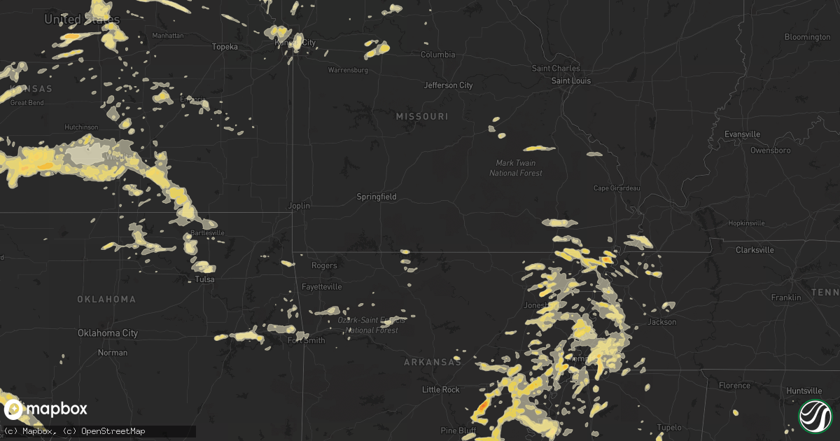
Hail Map in Nebraska on June 16, 2011
Get this storm
June 16 map
$229
one time, instant access
Download today. No call, no setup
Keep the $229
Bought the map and want the full workflow? Apply the entire $229 to a subscription within 7 days. None of it is wasted.
Every map, not just this one
This buys you this map. Subscription and you get every map we run, in the markets you choose from a few cities to whole states to nationwide. Plus real-time alerts the moment a storm fires.
Contact data
Name, contact info, occupancy, even credit band for addresses in the footprint. You go from where it hit to who to call.
Become the source they trust
Unlimited branding weather history reports on demand. You already have the documented answer ready for the property owner, and you are the one who showed up with it.
Property data and RoofTrace estimates
Pull up any address you have got, its value and the exact code rules for that jurisdiction, straight from One Click Code. Then RoofTrace estimates the squares, pitch, and roof value, priced the way you price.
Storm reports in Nebraska
Nebraska
| Date | Description |
|---|---|
| 06/16/20116:50 PM CDT | A local report indicates 1.00 inch wind near 30 SW MERRIMAN |
| 06/16/20116:35 PM CDT | Winds up to 40 mph. |
| 06/16/20116:35 PM CDT | Estimated 60 mile per hour winds with 4 inch diameter branches broken off |
| 06/16/20115:57 PM CDT | Graineries blown down. Tree branches down. 70 mph winds estimated. |
| 06/16/20115:56 PM CDT | A local report indicates 70 MPH wind near ALLIANCE |
| 06/16/20115:53 PM CDT | A local report indicates 67 MPH wind near ALLIANCE |
| 06/16/20115:42 PM CDT | 45 to 50 mph winds. |
| 06/16/20115:41 PM CDT | A local report indicates 1.50 inch wind near 20 SSW MERRIMAN |
| 06/16/20115:41 PM CDT | A local report indicates 1.25 inch wind near 7 S ELI |
| 06/16/20115:35 PM CDT | Numerous tree limbs and branches blown down. One 16 inch tree was split in half. |
| 06/16/20115:35 PM CDT | Heavy rain as well. |
| 06/16/20115:30 PM CDT | A local report indicates 1.00 inch wind near 3 SSW ELI |
| 06/16/20115:30 PM CDT | A local report indicates 1.00 inch wind near 4 SW ELI |
| 06/16/20115:09 PM CDT | A local report indicates 58 MPH wind near SCOTTSBLUFF |
| 06/16/20115:02 PM CDT | A local report indicates 59 MPH wind near SCOTTSBLUFF |
| 06/16/20114:56 PM CDT | Estimate winds from 50 to 60 mph |
| 06/16/20114:50 PM CDT | Spotter reported several good sized trees blown over in the scottsbluff area. Estimates winds to have been 60 to 65 mph. |
| 06/16/20114:49 PM CDT | Peak gust 54 kt. |
| 06/16/20114:49 PM CDT | 1-2 inch tree branches down throughout the city. |
| 06/16/20114:45 PM CDT | A local report indicates 1.00 inch wind near LYMAN |
| 06/16/20114:30 PM CDT | Graineries blown down. Tree branches down. 70 mph winds estimated. |
| 06/16/20114:30 PM CDT | Lasted 5 minutes. |
| 06/16/20114:25 PM CDT | A local report indicates 1.00 inch wind near LYMAN |
| 06/16/20114:15 PM CDT | Lasted 30 minutes. |
| 06/16/20111:35 AM CDT | A local report indicates 1.00 inch wind near 1 N NORFOLK |
| 06/15/201111:15 PM CDT | A local report indicates 60 MPH wind near JOHNSON LAKE |
| 06/15/201110:57 PM CDT | A local report indicates 62 MPH wind near LEXINGTON |
| 06/15/201110:55 PM CDT | A local report indicates 59 MPH wind near LEXINGTON AIRPORT |
| 06/15/201110:50 PM CDT | Several tree limbs down in cozad. Limbs are around 4 to 5 inches in diameter with at least one branch 8 inches in diameter. |
| 06/15/201110:45 PM CDT | A local report indicates 70 MPH wind near 2 S GOTHENBURG |
| 06/15/201110:45 PM CDT | Public reported 60 mph wind gusts in cozad. Road signs were blown over along highway 30. Plastic fencing and pipes also blown over from the nebraska plastic plant. |
| 06/15/201110:37 PM CDT | A local report indicates 60 MPH wind near 2 S GOTHENBURG |
| 06/15/201110:15 PM CDT | Coop observer estimated wind speeds in excess of 60 mph with several tree limbs down. Time for this reported is estimated. |
| 06/15/201110:12 PM CDT | Mostly nickel sized hail along with very heavy rainfall at time of report. |
| 06/15/201110:12 PM CDT | A local report indicates 67 MPH wind near 2 NE MCCOOK |
| 06/15/201110:07 PM CDT | A local report indicates 60 MPH wind near 2 NE MCCOOK |
| 06/15/20119:49 PM CDT | A local report indicates 1.75 inch wind near PAXTON |
| 06/15/20119:15 PM CDT | A local report indicates 63 MPH wind near 7 NW AINSWORTH |
| 06/15/20119:15 PM CDT | Gust to 63 mph was recorded by automatic equipment at the ainsworth airport. |
| 06/15/20119:10 PM CDT | Large marble to half dollar sized hail nearly covering the ground. |
| 06/15/20119:09 PM CDT | A local report indicates 1.00 inch wind near GRANT |
| 06/15/20119:00 PM CDT | A local report indicates 1.00 inch wind near 4 WNW GRANT |
| 06/15/20119:00 PM CDT | 3 to 4 inch branches were snapped off |
| 06/15/20119:00 PM CDT | Estimated wind gusts of at least 60 mph along with quarter sized hail. |
| 06/15/20118:58 PM CDT | A local report indicates 74 MPH wind near VALENTINE |
| 06/15/20118:50 PM CDT | A local report indicates 60 MPH wind near 12 NE VENANGO |
| 06/15/20118:45 PM CDT | A local report indicates 60 MPH wind near 29 S VALENTINE |
| 06/15/20118:35 PM CDT | Porch blown off of house |
| 06/15/20118:25 PM CDT | Trampoline took flight and hit house damaging an outside faucet and gutter damaged. Trampoline tumbled down hill from house. |
| 06/15/20118:22 PM CDT | A local report indicates 1.00 inch wind near 3 N CHAPPELL |
| 06/15/20118:20 PM CDT | A local report indicates 60 MPH wind near 12 S MERRITT RESERVOIR |
| 06/15/20118:06 PM CDT | Dime to quarter sized was also falling at this time. |
| 06/15/20118:05 PM CDT | Pickup truck and attached camper tipped over due to strong wind gusts near mile marker 70 on interstate 80. |
| 06/15/20117:58 PM CDT | A local report indicates 60 MPH wind near 36 W BROWNLEE |
| 06/15/20117:57 PM CDT | Also estimated 60 mile per hour wind gusts |
| 06/15/20117:55 PM CDT | A local report indicates 70 MPH wind near 6 N ARTHUR |
| 06/15/20117:55 PM CDT | A local report indicates 1.00 inch wind near 6 N ARTHUR |
| 06/15/20117:35 PM CDT | Hail up to quarter size also reported. |
| 06/15/20117:30 PM CDT | A local report indicates 1.00 inch wind near 2 W DIX |
| 06/15/20117:30 PM CDT | Estimated 5 inch branches were down due to wind. |
| 06/15/20117:28 PM CDT | Nickel to quarter hail coming down very hard |
| 06/15/20117:10 PM CDT | Intersection of interstate 80 and highway 71. |
All States Impacted by Hail Map on June 16, 2011
Cities Impacted by Hail Map on June 16, 2011
- Morrison, OK
- Glencoe, OK
- Walls, MS
- Lake Cormorant, MS
- Union City, TN
- Steele, MO
- Onaga, KS
- Grandfield, OK
- Devol, OK
- Como, MS
- Sardis, MS
- Marshall, MO
- Lamar, MS
- Moscow, TN
- Alliance, NE
- Houston, MS
- West Point, MS
- Cedarbluff, MS
- Woodland, MS
- Pheba, MS
- Mantee, MS
- Frankfort, KS
- Westmoreland, KS
- Grant, NE
- Venango, NE
- Wray, GA
- Fitzgerald, GA
- Broxton, GA
- Belgrade, ME
- Augusta, ME
- Stuttgart, AR
- Willow, OK
- Moro, AR
- Coleridge, NE
- Hartington, NE
- Shuqualak, MS
- Springfield, SD
- Hollister, OK
- Loveland, OK
- Frederick, OK
- Jonesboro, AR
- Patten, ME
- Ailey, GA
- Ulm, AR
- De Witt, AR
- Holly Grove, AR
- Crocketts Bluff, AR
- Marvell, AR
- Saint Charles, AR
- Clarendon, AR
- Elba, AL
- Hunter, OK
- Louisville, MS
- McCool, MS
- Ethel, MS
- Bristol, FL
- Hosford, FL
- Vivian, SD
- Draper, SD
- Cobb, GA
- Brinkley, AR
- Crawfordsville, AR
- Stafford, KS
- Paragould, AR
- Beech Grove, AR
- Delaplaine, AR
- Harrisburg, AR
- Sedgwick, CO
- Lodgepole, NE
- Crook, CO
- Sidney, NE
- Chappell, NE
- De Valls Bluff, AR
- Mathiston, MS
- Wray, CO
- El Paso, AR
- Mendon, MO
- Keytesville, MO
- Brunswick, MO
- Lena, MS
- Fort Smith, AR
- Gideon, MO
- Holcomb, MO
- Paxton, NE
- Bayard, NE
- Hughes, AR
- Heth, AR
- Proctor, AR
- Earle, AR
- Webbers Falls, OK
- Checotah, OK
- Porum, OK
- Warner, OK
- Valentine, NE
- Eufaula, OK
- Glenwood, AL
- Van Buren, AR
- Sperry, OK
- Skiatook, OK
- Birmingham, AL
- Potter, NE
- Almyra, AR
- Evergreen, AL
- Callaway, NE
- Gothenburg, NE
- Brady, NE
- Perry, GA
- Maxwell, NE
- Burwell, NE
- Ozark, AL
- Midland City, AL
- Conehatta, MS
- Merriman, NE
- Barnard, KS
- Portageville, MO
- Peel, AR
- Lead Hill, AR
- Yellville, AR
- Sutherland, NE
- Cuba, MO
- Ashland, ME
- Pawhuska, OK
- Sedan, KS
- Oneill, NE
- Yoder, WY
- Torrington, WY
- Russellville, AL
- Phil Campbell, AL
- Jetersville, VA
- Clay Center, KS
- Ralston, OK
- Wetumpka, AL
- Eclectic, AL
- Red Level, AL
- Andalusia, AL
- Scottsbluff, NE
- Minatare, NE
- McCrory, AR
- Hyde, PA
- Curwensville, PA
- Mahaffey, PA
- Grampian, PA
- Penfield, PA
- Luthersburg, PA
- Clearfield, PA
- Rockton, PA
- Poulan, GA
- Sylvester, GA
- Morganville, KS
- Montgomery, AL
- Stony Creek, VA
- Dinwiddie, VA
- Wynne, AR
- Cherry Valley, AR
- Allen, NE
- Elk Point, SD
- Moville, IA
- Correctionville, IA
- Dakota City, NE
- Merrill, IA
- South Sioux City, NE
- Jefferson, SD
- Hinton, IA
- Bronson, IA
- Ponca, NE
- Waterbury, NE
- Homer, NE
- Washta, IA
- Sergeant Bluff, IA
- Jackson, NE
- Emerson, NE
- Sioux City, IA
- Salix, IA
- Le Mars, IA
- Lawton, IA
- Hubbard, NE
- North Sioux City, SD
- Kingsley, IA
- Pierson, IA
- Jasper, AR
- Willacoochee, GA
- Morrill, KS
- Sabetha, KS
- Hiawatha, KS
- Fairview, KS
- Kansas City, KS
- Millinocket, ME
- Gordon, NE
- Spearville, KS
- Wright, KS
- Jetmore, KS
- Peabody, KS
- Walton, KS
- Newton, KS
- Mason, TN
- Cunningham, KS
- North Platte, NE
- Wayne, NE
- Laurel, NE
- Crenshaw, MS
- Turon, KS
- Gould, AR
- Hernando, MS
- Moundridge, KS
- Hesston, KS
- Ashland, NE
- Greenwood, NE
- Goddard, KS
- Clearwater, KS
- Oakland, TN
- Eads, TN
- Arlington, TN
- Cassoday, KS
- Beloit, KS
- Dorrance, KS
- Wilson, KS
- Lincoln, KS
- Presho, SD
- Fort Pierre, SD
- Murdo, SD
- Norfolk, NE
- Pierce, NE
- Hoskins, NE
- Barnard, MO
- Maryville, MO
- Jachin, AL
- York, AL
- Ward, AL
- Lisman, AL
- Butler, AL
- Saint Francis, KS
- Olustee, OK
- Walters, OK
- Chattanooga, OK
- Duke, OK
- Altus, OK
- Tipton, OK
- Blair, OK
- Snyder, OK
- Hollis, OK
- Altus Afb, OK
- Gould, OK
- Dodson, TX
- Indiahoma, OK
- Randlett, OK
- Headrick, OK
- Mangum, OK
- Cheyenne, WY
- Widener, AR
- Sawyer, KS
- Pratt, KS
- Isabel, KS
- Coldwater, MS
- Bennington, KS
- Minneapolis, KS
- Solomon, KS
- Garber, OK
- Tonkawa, OK
- Billings, OK
- Cuthbert, GA
- Coleman, GA
- Walnut Ridge, AR
- Ambrose, GA
- Douglas, GA
- Aurora, KS
- Concordia, KS
- Galva, KS
- Canton, KS
- Marion, KS
- Bassett, NE
- Blackburn, MO
- Malta Bend, MO
- Beverly, KS
- Sylvan Grove, KS
- Hoisington, KS
- Russell, KS
- Robertsdale, AL
- Clarksdale, MS
- Hanston, KS
- Bazine, KS
- Ness City, KS
- Ogallala, NE
- Ozark, AR
- Mountainburg, AR
- Gering, NE
- Rush Center, KS
- Altus, AR
- Clarksville, AR
- Pitts, GA
- Nashville, KS
- Kingman, KS
- Haviland, KS
- Sun City, KS
- Mullinville, KS
- Lewis, KS
- Coats, KS
- Spivey, KS
- Wilmore, KS
- Iuka, KS
- Byers, KS
- Greensburg, KS
- Kinsley, KS
- Searcy, AR
- New Sharon, ME
- Oakland, ME
- Belgrade Lakes, ME
- Conway Springs, KS
- Viola, KS
- Milton, KS
- Norwich, KS
- Cheney, KS
- Mobile, AL
- Theodore, AL
- Cottondale, FL
- Chipley, FL
- Martin, TN
- Rives, TN
- Marshall, VA
- Mercer, PA
- Saint Francis, ME
- Chillicothe, MO
- Protem, MO
- Frenchmans Bayou, AR
- Luxora, AR
- Eastman, GA
- Cochran, GA
- Loxley, AL
- Dover, AR
- Griffithville, AR
- Des Arc, AR
- Assaria, KS
- Gypsum, KS
- Lindsborg, KS
- Vidalia, GA
- Westville, OK
- Verbena, AL
- Billingsley, AL
- Prattville, AL
- Genoa, CO
- Limon, CO
- Lindon, CO
- Agate, CO
- Arriba, CO
- Sparks, GA
- Adel, GA
- Leslie, GA
- Buford, WY
- Lumber City, GA
- Jacksonville, GA
- Denton, GA
- McRae Helena, GA
- Hazlehurst, GA
- Kirk, CO
- Pocahontas, AR
- Biggers, AR
- Maynard, AR
- Du Bois, PA
- Avon, SD
- Exmore, VA
- Belle Haven, VA
- Melfa, VA
- Quinby, VA
- Painter, VA
- Altamont, MO
- Cameron, MO
- Hamilton, MO
- Weatherby, MO
- Maysville, MO
- Kidder, MO
- Pattonsburg, MO
- Winston, MO
- Gallatin, MO
- Rockford, AL
- Palisade, NE
- Verdigre, NE
- Niobrara, NE
- Beeler, KS
- Fordyce, NE
- Hayti, MO
- Caruthersville, MO
- Wakefield, NE
- Germantown, TN
- Memphis, TN
- Cordova, TN
- Millington, TN
- Collierville, TN
- Olive Branch, MS
- Fairfax, MO
- Sneads, FL
- Red Rock, OK
- Albany, GA
- Leesburg, GA
- Rozel, KS
- Braman, OK
- Aubrey, AR
- Pawnee, OK
- Wellington, KS
- Ford, KS
- Belpre, KS
- Garfield, KS
- Bucklin, KS
- Zenda, KS
- Garden Plain, KS
- Dodge City, KS
- Offerle, KS
- Mulvane, KS
- Cimarron, KS
- Peck, KS
- Derby, KS
- Haysville, KS
- Murdock, KS
- Wichita, KS
- Humnoke, AR
- Hazen, AR
- Altheimer, AR
- Humphrey, AR
- Wabbaseka, AR
- Carlisle, AR
- Tallassee, AL
- Atlanta, KS
- Douglass, KS
- Bingham, NE
- Amelia, NE
- Saint Francis, SD
- Mission, SD
- Corning, AR
- Peach Orchard, AR
- Rossville, TN
- Louisville, AL
- Sharon, TN
- Burlington, CO
- Idalia, CO
- Haven, KS
- Wilsonville, AL
- Columbiana, AL
- Plainview, NE
- Caledonia, MO
- Irondale, MO
- Potosi, MO
- Belgrade, MO
- Hume, VA
- Linden, VA
- Front Royal, VA
- Chester Gap, VA
- Huntly, VA
- Carr, CO
- Brundidge, AL
- Troy, AL
- Perryville, MO
- Tulsa, OK
- Burlington, KS
- Quitman, GA
- Abbeville, GA
- Marked Tree, AR
- Caraway, AR
- Wheatley, AR
- Palestine, AR
- Cotton Plant, AR
- Blue Rapids, KS
- Rulo, NE
- Belle Plaine, KS
- Udall, KS
- Oxford, KS
- Winfield, KS
- Alexander, KS
- Everton, AR
- Saint Joe, AR
- Oneida, KS
- Table Rock, NE
- Du Bois, NE
- Humboldt, NE
- Bern, KS
- Pawnee City, NE
- Hickory Valley, TN
- Grand Junction, TN
- La Grange, TN
- Dawson, GA
- Fort Collins, CO
- Loveland, CO
- Okaton, SD
- El Dorado, KS
- Florala, AL
- Sargent, NE
- Anselmo, NE
- Broken Bow, NE
- Taylor, NE
- Laramie, WY
- Wilmer, AL
- Lucedale, MS
- Ripley, MS
- Sentinel, OK
- Carter, OK
- Lone Wolf, OK
- Granite, OK
- Muldrow, OK
- Sallisaw, OK
- Greenleaf, KS
- Linn, KS
- Barnes, KS
- Waterville, KS
- Akron, IA
- Hawarden, IA
- Chatsworth, IA
- Alcester, SD
- Senath, MO
- Arbyrd, MO
- Stanton, NE
- Pilger, NE
- Hartford, KS
- Emporia, KS
- Neosho Rapids, KS
- Concord, VA
- Lynchburg, VA
- Bonesteel, SD
- Waynesboro, MS
- Silas, AL
- Gilbertown, AL
- Needham, AL
- Milan, TN
- Medina, TN
- Bluffton, GA
- Gorham, ME
- Colony, KS
- Ainsworth, NE
- Columbia, AL
- Weir, MS
- Hemingford, NE
- Oshkosh, NE
- Vian, OK
- Sapelo Island, GA
- Bismarck, MO
- Park Hills, MO
- Tecumseh, NE
- Steinauer, NE
- Arnold, NE
- Moberly, MO
- Cairo, MO
- Auburn, AL
- Salem, AL
- Notasulga, AL
- Opelika, AL
- Luverne, AL
- Brantley, AL
- Ray City, GA
- Nashville, GA
- Lakeland, GA
- Lumberton, NC
- Ripley, TN
- Henning, TN
- Dix, NE
- White River, SD
- Trimble, MO
- Valdosta, GA
- Chauncey, GA
- Milan, GA
- Lafe, AR
- Marmaduke, AR
- Oconto, NE
- Stilwell, OK
- Shelby, AL
- Sylacauga, AL
- Lagrange, WY
- Kincaid, KS
- Ellsworth, NE
- Hay Springs, NE
- Dundee, MS
- Arcadia, FL
- Campbell, MO
- Clarkton, MO
- Malden, MO
- Paducah, KY
- Piggott, AR
- Qulin, MO
- Pollard, AR
- Saint Francis, AR
- Humboldt, TN
- Jackson, AL
- Broadwater, NE
- Neelyville, MO
- Poplar Bluff, MO
- Harviell, MO
- Jay, OK
- Karnak, IL
- Metropolis, IL
- Grand Chain, IL
- Banks, AL
- Canton, MS
- Union Springs, AL
- Hope, KS
- Padroni, CO
- Lake City, AR
- Burdett, KS
- Haigler, NE
- Tillar, AR
- Branch, AR
- Gillett, AR
- Shellman, GA
- Rock Springs, WY
- Carthage, MS
- Kosciusko, MS
- Philadelphia, MS
- Winslow, AR
- Osmond, NE
- Meadow Grove, NE
- Neligh, NE
- Hortense, GA
- Jesup, GA
- Fort Myers, FL
- Lehigh Acres, FL
- Mitchell, NE
- Bedford, VA
- Ponca City, OK
- Tallahassee, FL
- Arlington, KS
- Pretty Prairie, KS
- Partridge, KS
- Tuthill, SD
- Marianna, AR
- Deer, AR
- Hawk Springs, WY
- Punxsutawney, PA
- Summerville, PA
- Brookville, PA
- Coolspring, PA
- Knox Dale, PA
- Ringgold, PA
- Sprankle Mills, PA
- Mayport, PA
- Worthville, PA
- Timblin, PA
- Camden, MS
- Cody, NE
- Henryetta, OK
- Dothan, AL
- Cedar Vale, KS
- Ackerman, MS
- Dyess, AR
- Osceola, AR
- Wilson, AR
- Joiner, AR
- Finley, TN
- Lexa, AR
- Alapaha, GA
- Lenox, GA
- Falun, KS
- Drummonds, TN
- Munford, TN
- Glenwood, GA
- Mount Vernon, GA
- Manila, AR
- Bay, AR
- Forrest City, AR
- Grady, AR
- Lyon, MS
- Dumas, AR
- Elaine, AR
- Coahoma, MS
- Castleberry, AL
- Madrid, NE
- Dawson, NE
- Chambers, NE
- Pelham, AL
- Wynona, OK
- Barnsdall, OK
- Cullman, AL
- Nesbit, MS
- Arthur, NE
- Dyersburg, TN
- Friendship, TN
- Dinosaur, CO
- Fairmount City, PA
- Glasco, KS
- Miltonvale, KS
- Scandia, KS
- Jamestown, KS
- Belleville, KS
- Delphos, KS
- Clyde, KS
- Brunswick, GA
- Crookston, NE
- Houstonia, MO
- Sweet Springs, MO
- Augusta, AR
- Fairfax, OK
- Randolph, NE
- Marion, AR
- Julesburg, CO
- Screven, GA
- Townsend, GA
- Darien, GA
- Lagrange, GA
- Goodman, MS
- Steelville, MO
- Greenup, KY
- Grayson, KY
- Pine Bluff, AR
- Burden, KS
- Cottonwood, AL
- Leavenworth, KS
- Lansing, KS
- West Memphis, AR
- Bay Minette, AL
- Williamsville, MO
- Blue Mountain, MS
- Pine Mountain, GA
- Peetz, CO
- Dewey, OK
- Senatobia, MS
- Bassett, AR
- Somerville, TN
- Turrell, AR
- Williston, TN
- Brighton, TN
- Stanton, TN
- Atoka, TN
- Utica, KS
- Joes, CO
- New Bethlehem, PA
- Templeton, PA
- Standish, ME
- Ansley, NE
- Clarksville, OH
- Ashford, AL
- Merna, NE
- Brewster, NE
- Deer Trail, CO
- Rustburg, VA
- Gladys, VA
- Herington, KS
- Carrollton, MO
- Fowler, OH
- Kinsman, OH
- Burghill, OH
- Cherokee, OK
- Elsie, NE
- Hornbeak, TN
- Obion, TN
- White Cloud, KS
- Craig, MO
- Kenton, TN
- Pontotoc, MS
- Thaxton, MS
- Walston, PA
- Hamilton, PA
- Northpoint, PA
- Valier, PA
- Strattanville, PA
- Sigel, PA
- Corsica, PA
- Homerville, GA
- Junction City, KS
- Woodbine, KS
- Valley Falls, KS
- Greenville, PA
- Encampment, WY
- Casper, WY
- Glenrock, WY
- Gridley, KS
- Walnut Grove, MS
- Abilene, KS
- Longford, KS
- Blakely, GA
- Tyndall, SD
- Rock River, WY
- Dozier, AL
- Tryon, NE
- Weiner, AR
- Equality, AL
- Bono, AR
- Quitman, MS
- Grand Ridge, FL
- Wagner, SD
- Hershey, NE
- Dickens, NE
- Olpe, KS
- Omega, GA
- Norman Park, GA
- Moody Afb, GA
- Du Pont, GA
- Ellenton, GA
- Enigma, GA
- Tifton, GA
- Greenwood, FL
- Trimble, TN
- Ridgely, TN
- Cook, NE
- Olmitz, KS
- Cortland, OH
- Farmdale, OH
- Sharpsville, PA
- Transfer, PA
- Lenexa, KS
- Overland Park, KS
- Shawnee, KS
- Tupelo, MS
- Shannon, MS
- Okolona, MS
- Craig, CO
- Burbank, OK
- Shidler, OK
- Sledge, MS
- Wallace, NE
- Brule, NE
- Wellfleet, NE
- Helena, AR
- Kansas City, MO
- Macon, MS
- Pansey, AL
- Gordon, AL
- Kimball, NE
- Robinson, KS
- Newport, AR
- Blackshear, GA
- West Point, GA
- Augusta, KS
- Rose Hill, KS
- Andover, KS
- Victoria, VA
- New Brockton, AL
- Enterprise, AL
- Webb, AL
- Cowarts, AL
- Headland, AL
- Marquette, KS
- Bay Springs, MS
- Bruce, MS
- Marks, MS
- Buena Vista, GA
- Rupert, GA
- Ellaville, GA
- Mauk, GA
- Columbus, GA
- Morrill, NE
- Lyman, NE
- Kinston, AL
- Opp, AL
- Arlington, AL
- Brookland, AR
- Harrison, NE
- Melbeta, NE
- Rushville, NE
- Blytheville, AR
- Hamilton, GA
- De Lancey, PA
- Smicksburg, PA
- Oliveburg, PA
- Dayton, PA
- Nebraska City, NE
- Broseley, MO
- Bernie, MO
- Otis, KS
- Albert, KS
- Troy, KS
- Halls, TN
- Bragg City, MO
- Brockway, PA
- Rhine, GA
- Drifting, PA
- Lanse, PA
- Kylertown, PA
- Woodland, PA
- Morrisdale, PA
- Grassflat, PA
- Clark, CO
- Collinsville, OK
- Owasso, OK
- Mankato, KS
- Webber, KS
- Ledbetter, KY
- Marianna, FL
- Patterson, GA
- Biscoe, AR
- Trumann, AR
- Waldron, MO
- Platte City, MO
- Basehor, KS
- Church Creek, MD
- Cambridge, MD
- Winside, NE
- Veteran, WY
- Maben, MS
- Houlka, MS
- Cambridge, KS
- Latham, KS
- Hillsboro, KS
- Lehigh, KS
- Cleveland, OH
- Beachwood, OH
- Gates Mills, OH
- Novelty, OH
- Chagrin Falls, OH
- West Helena, AR
- Clinton, KY
- Witts Springs, AR
- Oskaloosa, KS
- French Camp, MS
- Wardell, MO
- Kennett, MO
- Cuba, KS
- Agenda, KS
- Triplett, MO
- Sterling, NE
- Coffee Springs, AL
- Samson, AL
- Ovid, CO
- Meriden, WY
- Holly Springs, MS
- Michigan City, MS
- Lewellen, NE
- Vienna, MD
- Newton, MS
- Lawrence, MS
- Bartlesville, OK
- Blountstown, FL
- Altha, FL
- Stewart, MS
- Childress, TX
- Bendena, KS
- Wathena, KS
- Rushville, MO
- Saint Joseph, MO
- Atchison, KS
- Bosler, WY
- Waycross, GA
- Hawthorn, PA
- Clarion, PA
- Sligo, PA
- Reynoldsville, PA
- Glade, KS
- Stockton, KS
- Heidelberg, MS
- Pine Mountain Valley, GA
- Shiloh, GA
- Union, MS
- Boaz, KY
- North Bloomfield, OH
- Westfield, IA
- Keota, OK
- Stigler, OK
- Saucier, MS
- Lathrop, MO
- Williamsfield, OH
- Andover, OH
- Orwell, OH
- Wheatland, WY
- Patuxent River, MD
- Crapo, MD
- Fishing Creek, MD
- Brandon, MS
- Council Grove, KS
- Wellington, CO
- Hayden, CO
- Harrisburg, MO
- Rocheport, MO
- Hutchinson, KS
- Burrton, KS
- Eucha, OK
- Hahira, GA
- Rector, AR
- Breckenridge, MO
- Martin, SD
- Hornersville, MO
- Cardwell, MO
- Watson, AR
- Maize, KS
- Vona, CO
- Larned, KS
- Great Bend, KS
- Bison, KS
- Albin, WY
- Garrett, WY
- Rochelle, GA
- Red Feather Lakes, CO
- Lepanto, AR
- Etowah, AR
- Wilsey, KS
- Strong City, KS
- Elmdale, KS
- Cottonwood Falls, KS
- Vardaman, MS
- Calhoun City, MS
- Eupora, MS
- Sturgis, MS
- Tonganoxie, KS
- Farley, MO
- Farrell, PA
- Masury, OH
- Hermitage, PA
- Sharon, PA
- Romance, AR
- Beebe, AR
- Oregon, MO
- De Kalb, MO
- Poplar Grove, AR
- Gower, MO
- Brownell, KS
- Ransom, KS
- Tescott, KS
- Pettigrew, AR
- Alford, FL
- Strang, OK
- Colcord, OK
- Immokalee, FL
- Flagler, CO
- Maitland, MO
- Sand Springs, OK
- Hamilton, CO
- Denison, KS
- Holton, KS
- Victoria, KS
- Hays, KS
- Pfeifer, KS
- Gorham, KS
- Mcpherson, KS
- Ashby, NE
- Wappapello, MO
- Ellsinore, MO
- Bells, TN
- Leon, KS
- Farmville, VA
- Prospect, VA
- La Crosse, KS
- Edison, GA
- Mellwood, AR
- Friars Point, MS
- Lambert, MS
- Goodwin, AR
- Hickman, KY
- Brickeys, AR
- Lincolnville, KS
- Welda, KS
- Madison, AL
- Maysville, AR
- Gentry, AR
- Waynesville, GA
- Perkinston, MS
- Belknap, IL
- Nicholls, GA
- Carroll, NE
- Ramona, OK
- Roland, OK
- Meridian, MS
- Naper, NE
- Goldsboro, NC
- Dudley, NC
- Linesville, PA
- Pierpont, OH
- Conneautville, PA
- McIntosh, AL
- Peru, KS
- Grenola, KS
- Chautauqua, KS
- Moline, KS
- Ochopee, FL
- Star City, AR
- Noxapater, MS
- Roe, AR
- Nowata, OK
- McCracken, KS
- Medford, OK
- Lisco, NE
- Paulding, MS
- Stratton, CO
- Fort Gaines, GA
- Imperial, NE
- Haxtun, CO
- Big Springs, NE
- Calera, AL
- Newville, AL
- Toomsuba, MS
- Evergreen, NC
- Monson, ME
- Burlington, ME
- Lincoln, ME
- Rosalia, KS
- Drake, CO
- Andale, KS
- Mount Hope, KS
- Colwich, KS
- Le Roy, KS
- Tampa, KS
- Meadville, PA
- Alamo, TN
- Iowa Falls, IA
- South Haven, KS
- Newkirk, OK
- Arkansas City, KS
- Spout Spring, VA
- Appomattox, VA
- Waverly, AL
- Eckley, CO
- Shubert, NE
- Dighton, KS
- Pierre, SD
- Maybell, CO
- Rangely, CO
- Norborne, MO
- Milton, FL
- Welling, OK
- Myrtle, MS
- Vancleave, MS
- Bridgeport, NE
- Cope, CO
- Preston, MS
- Cherryville, MO
- Parks, NE
- Brookville, KS
- Mechanicsburg, OH
- Urbana, OH
- Wauneta, NE
- Eudora, KS
- Alamo, GA
- Whitewater, KS
- Clio, AL
- Brownsville, TN
- Fisher, AR
- Courtland, KS
- La Monte, MO
- Cedar Point, KS
- Marland, OK
- Durham, KS
- Ingalls, KS
- East Prairie, MO
- Fulton, KY
- Southaven, MS
- Horn Lake, MS
- Elko, GA
- Liberty, MO
- Independence, MO
- Mission, KS
- Bates City, MO
- Oak Grove, MO
- Highland, KS
- Endicott, NE
- Higbee, MO
- Newcastle, NE
- Bunch, OK
- Bristolville, OH
- Rome, OH
- Jefferson, OH
- Clayton, AL
- Burbank, SD
- Vermillion, SD
- London, OH
- West Jefferson, OH
- Galloway, OH
- Toxey, AL
- Falkville, AL
- Vinemont, AL
- Atlantic, PA
- Edgerton, MO
- Seminole, PA
- Lavinia, TN
- Sumner, GA
- Garden City, KS
- Macksville, KS
- Hagarville, AR
- Hector, AR
- Pelsor, AR
- Jerusalem, AR
- Champion, NE
- Towanda, KS
- Robinsonville, MS
- Tunica, MS
- Sarah, MS
- Elk Creek, NE
- Mulberry, AR
- Copan, OK
- Rarden, OH
- Clifton, KS
- Lucas, KS
- Hyannis, NE
- Wood, SD
- Rosebud, SD
- Grain Valley, MO
- Blue Springs, MO
- Stapleton, AL
- Gravette, AR
- Sulphur Springs, AR
- Irwin, PA
- Trafford, PA
- Granite Canon, WY
- Anadarko, OK
- Weogufka, AL
- Morgan, GA
- Kingston, MO
- Ramona, KS
- West Decatur, PA
- Mayetta, KS
- Saint James, MO
- Bellefonte, PA
- Otis, CO
- Marbury, AL
- Lees Summit, MO
- Saint Simons Island, GA
- Platte, SD
- Marston, MO
- New Madrid, MO
- Matthews, MO
- Lynch, NE
- Amissville, VA
- Ariton, AL
- Americus, GA
- De Soto, GA
- Odessa, MO
- Blunt, SD
- Chunchula, AL
- Goessel, KS
- Morton, MS
- Pelahatchie, MS
- Chester, AR
- Byhalia, MS
- Newville, PA
- Safford, AL
- Titus, AL
- Pope, MS
- Courtland, MS
- Oakland, MS
- Chugwater, WY
- McKenzie, AL
- Yuma, CO
- Volant, PA
- Slippery Rock, PA
- Elkins, AR
- Lebo, KS
- Waverly, KS
- Copeland, KS
- Markham, VA
- Valley Center, KS
- Highland Home, AL
- Burdick, KS
- South Fulton, TN
- Gates, TN
- Monette, AR
- Covington, TN
- Knobel, AR
- Cooter, MO
- Black Oak, AR
- Gilmore, AR
- Gobler, MO
- Keiser, AR
- Burlison, TN
- Leachville, AR
- Harrisburg, NE
- Gore, OK
- Culpeper, VA
- Castleton, VA
- Rixeyville, VA
- Boston, VA
- Brandy Station, VA
- Forkland, AL
- Greenfield, TN
- Hayes Center, NE
- Skipperville, AL
- Abbeville, AL
- Mcconnell Afb, KS
- Rock, KS
- McLouth, KS
- Lock Springs, MO
- Jamesport, MO
- Jameson, MO
- Mooresville, MO
- Burchard, NE
- Spavinaw, OK
- Vinita, OK
- Fisk, MO
- Wakefield, KS
- Readfield, ME
- Sugar Grove, PA
- Saint Charles, SD
- Muskogee, OK
- Penokee, KS
- Brunswick, NE
- Belden, NE
- Leonardville, KS
- Green, KS
- Plattsburg, MO
- Ackley, IA
- Hampton, IA
- Burns, KS
- Potwin, KS
- Benkelman, NE
- Onida, SD
- Leawood, KS
- Stilwell, KS
- Wilmington, OH
- Florence, KS
- Silverhill, AL
- Orchard, NE
- Page, NE
- Inman, NE
- Troy, TN
- Grandin, MO
- Puxico, MO
- Dudley, MO
- Iola, KS
- Evington, VA
- Huddleston, VA
- Forest, VA
- Ellsworth, KS
- Cambridge Springs, PA
- Edinboro, PA
- Saint Paul, AR
- West Portsmouth, OH
- Dexter, KS
- Republic, KS
- Greenway, AR
- Mineral Springs, PA
- Polk, PA
- Bogue, KS
- Jamestown, PA
- Hartstown, PA
- Salina, KS
- Allen, KS
- Bentley, KS
- Sedgwick, KS
- Wann, OK
- Greenwich, KS
- Benton, KS
- Delaware, OK
- Kechi, KS
- Deatsville, AL
- Punta Gorda, FL
- Cordele, GA
- England, AR
- Dante, SD
- Sublette, KS
- Vernon, CO
- Morven, GA
- Melvin, AL
- Shubuta, MS
- Centennial, WY
- Glendo, WY
- Colt, AR
- Alva, FL
- North Fort Myers, FL
- Madison, AR
- Tichnor, AR
- Tyronza, AR
- Parkin, AR
- Alligator, MS
- Julian, PA
- Utica, SD
- Quincy, FL
- Pickens, MS
- Ashland, MS
- Saulsbury, TN
- Walnut, MS
- Pennington, AL
- Camp Hill, AL
- Tabor, SD
- Creola, AL
- Emelle, AL
- Jack, AL
- Tilden, NE
- Benton, KY
- Calvert City, KY
- Olsburg, KS
- Palmer, KS
- Clanton, AL
- Batesville, MS
- Holyrood, KS
- Amelia Court House, VA
- Rice, VA
- Leslie, AR
- Soldier, KS
- Havensville, KS
- Vermillion, KS
- Centralia, KS
- Scotland, SD
- Slocomb, AL
- Newton, AL
- Axis, AL
- Proctor, OK
- Angora, NE
- Jackson, TN
- Cedar Grove, TN
- Falls Creek, PA
- Brockport, PA
- Smithville, MO
- Weston, MO
- Fredericksburg, VA


