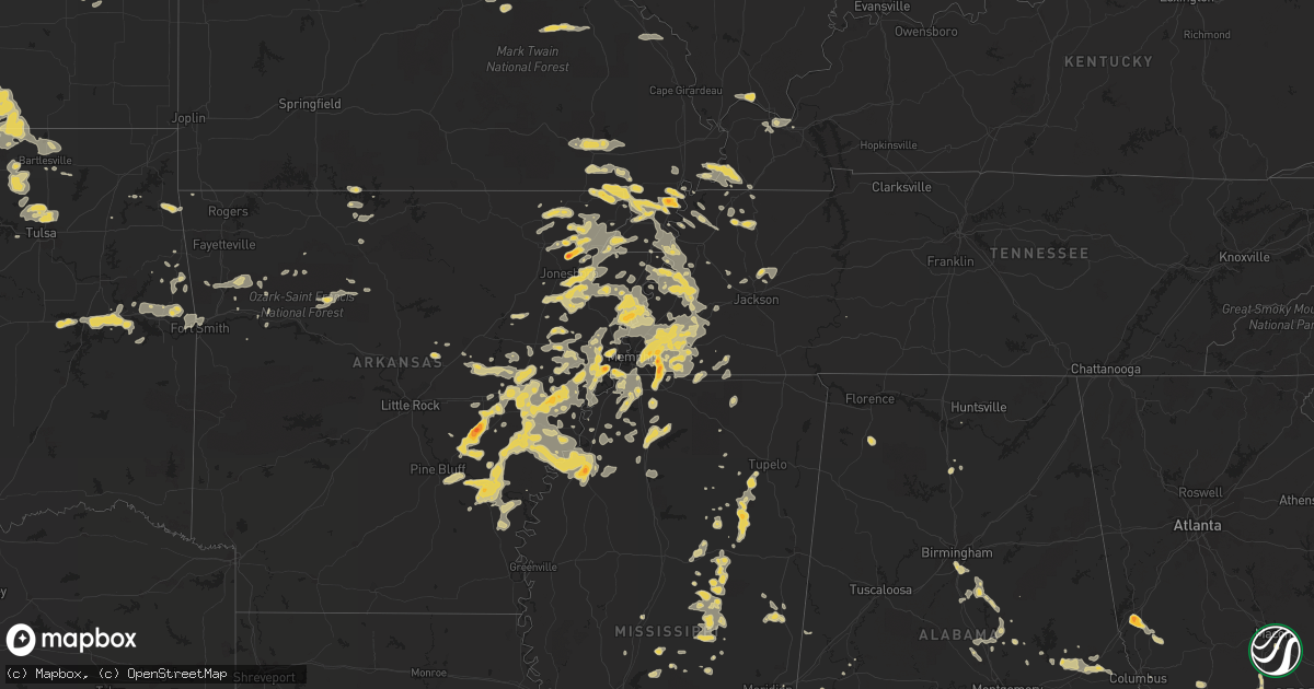
Hail Map on June 16, 2011
Get this storm
June 16 map
$229
one time, instant access
Download today. No call, no setup
Keep the $229
Bought the map and want the full workflow? Apply the entire $229 to a subscription within 7 days. None of it is wasted.
Every map, not just this one
This buys you this map. Subscription and you get every map we run, in the markets you choose from a few cities to whole states to nationwide. Plus real-time alerts the moment a storm fires.
Contact data
Name, contact info, occupancy, even credit band for addresses in the footprint. You go from where it hit to who to call.
Become the source they trust
Unlimited branding weather history reports on demand. You already have the documented answer ready for the property owner, and you are the one who showed up with it.
Property data and RoofTrace estimates
Pull up any address you have got, its value and the exact code rules for that jurisdiction, straight from One Click Code. Then RoofTrace estimates the squares, pitch, and roof value, priced the way you price.
States Impacted by Hail Map on June 16, 2011
Storm reports
New York
| Date | Description |
|---|---|
| 06/16/20115:45 PM CDT | Trees and lines down. |
Tennessee
| Date | Description |
|---|---|
| 06/16/20116:55 PM CDT | Asos recorded peak wind of 73 mph at 655 |
| 06/15/20119:20 PM CDT | Trees down across southern portions of the county. |
| 06/15/20119:13 PM CDT | Trees down along bible hill road. |
| 06/15/20119:00 PM CDT | A couple of trees were blown down in the town of huntingdon. |
| 06/15/20118:50 PM CDT | Trees down throughout the county. |
| 06/15/20118:08 PM CDT | A local report indicates 60 MPH wind near BOLIVAR |
| 06/15/20118:00 PM CDT | Power lines down on johnson road...trees down...damage to a storage building. |
| 06/15/20117:55 PM CDT | A local report indicates 60 MPH wind near BOLIVAR |
| 06/15/20117:45 PM CDT | A couple of trees down near highway 88. |
| 06/15/20117:40 PM CDT | Nws employee reported large trees down on interstate 40 between mile markers 43 and 45. Time is estimated. |
| 06/15/20117:30 PM CDT | A local report indicates 1.00 inch wind near HICKORY WITHE |
| 06/15/20117:30 PM CDT | Power lines down on chester street and on orr road outside of the fire station. |
| 06/15/20117:30 PM CDT | Meteorologist estimated a 65 mph wind gust with storm. |
| 06/15/20117:20 PM CDT | A local report indicates 60 MPH wind near ELLENDALE |
| 06/15/20117:20 PM CDT | Trees down |
| 06/15/20117:20 PM CDT | Quarter size hail and 50 mph winds with some trees down near walnut grove and sanga |
| 06/15/20117:17 PM CDT | 1.25 inch hail and high winds about 60 mph. |
| 06/15/20117:15 PM CDT | Spotter measured 60 mph gust on personal weather station |
| 06/15/20117:15 PM CDT | Wind gust measured on weather station of 63 mph. |
| 06/15/20117:15 PM CDT | A local report indicates 1.00 inch wind near GERMANTOWN |
| 06/15/20117:15 PM CDT | A local report indicates 1.75 inch wind near CORDOVA |
| 06/15/20117:15 PM CDT | A local report indicates 1.00 inch wind near 3 SW CORDOVA |
| 06/15/20117:12 PM CDT | A couple of trees down in the town of ripley. |
| 06/15/20117:12 PM CDT | A local report indicates 1.00 inch wind near 1 NNE GERMANTOWN |
| 06/15/20117:11 PM CDT | A local report indicates 2.00 inch wind near GERMANTOWN |
| 06/15/20117:10 PM CDT | A local report indicates 1.00 inch wind near 1 E GERMANTOWN |
| 06/15/20117:08 PM CDT | Trees down in the waverly area. |
| 06/15/20117:05 PM CDT | Quarter to ping pong ball size hail. Started at about 705 pm and lasted for about 5 minutes. |
Mississippi
| Date | Description |
|---|---|
| 06/16/20116:58 PM CDT | Quarter size hail near elmore and goodman |
| 06/16/20116:02 PM CDT | A local report indicates 1.25 inch wind near EDINBURG |
| 06/16/20115:50 PM CDT | Reported along county road 397. |
| 06/16/20115:46 PM CDT | A local report indicates 1.00 inch wind near COMO |
| 06/16/20115:46 PM CDT | A few trees down near hwy 310 outside of como. |
| 06/16/20115:35 PM CDT | 4 to 6 inch limbs down along hwy 315 just outside of sardis. |
| 06/16/20115:10 PM CDT | A local report indicates 1.25 inch wind near 3 WSW ACKERMAN |
| 06/16/20115:08 PM CDT | Covered the ground on the south side of town |
| 06/16/20115:05 PM CDT | A local report indicates 1.25 inch wind near 3 WSW ACKERMAN |
| 06/16/20114:45 PM CDT | Trees downed at the intersection of hwy 45 and hwy 145. |
| 06/16/20114:45 PM CDT | A tree fell on a house along skyland dr |
| 06/16/20114:44 PM CDT | On collier rd |
| 06/16/20114:44 PM CDT | A couple trees were down |
| 06/16/20114:40 PM CDT | A few trees were down along stewart-lodi rd |
| 06/16/20113:21 PM CDT | Covered the ground along jones rd |
| 06/16/20112:30 PM CDT | A small tree and tree branches were downed...partially blocking highway 46. |
| 06/15/20119:17 PM CDT | Quarter to golf ball size hail in lyon |
| 06/15/20119:16 PM CDT | A local report indicates 1.00 inch wind near CLARKSDALE |
| 06/15/20119:14 PM CDT | A local report indicates 1.00 inch wind near CLARKSDALE |
| 06/15/20117:40 PM CDT | Quarter size hail near hwy 78 and magnolia drive. |
| 06/15/20117:24 PM CDT | A few trees were down on power lines |
| 06/15/20117:02 PM CDT | Tree down on powerline |
| 06/15/20117:02 PM CDT | Covered the ground and lasted for 15 min |
North Carolina
| Date | Description |
|---|---|
| 06/15/20117:20 PM CDT | Quarter sized hail fell for about 5 minutes near the intersection of highway 211 and harris rd. |
Colorado
| Date | Description |
|---|---|
| 06/16/20116:50 PM CDT | A local report indicates 1.25 inch wind near 6 E KIRK |
| 06/16/20116:00 PM CDT | Estimated wind gusts 50 to 60 mph. |
| 06/16/20115:53 PM CDT | Winds 35046g77 mph at 1649 mdt |
| 06/16/20115:40 PM CDT | 20 to 40 foot section of barn knocked over along with several trees uprooted and or knocked down. |
| 06/16/20115:37 PM CDT | South winds sustained at 31 mph. Davis wx equip. |
| 06/16/20115:32 PM CDT | A local report indicates 60 MPH wind near WOODROW |
| 06/16/20115:18 PM CDT | Sustained winds 30 to 40 mph. Davis wx equip. |
| 06/16/20115:04 PM CDT | A local report indicates 63 MPH wind near PARKER |
| 06/16/20114:33 PM CDT | A local report indicates 68 MPH wind near 1 N STRASBURG |
| 06/15/20119:10 PM CDT | A local report indicates 1.00 inch wind near FORT COLLINS |
| 06/15/20119:00 PM CDT | Most hail penny size. |
| 06/15/20118:53 PM CDT | One inch to 1 1/4 inch hail. No wind. No rain. |
| 06/15/20118:40 PM CDT | A local report indicates 1.00 inch wind near E MASONVILLE |
| 06/15/20118:15 PM CDT | A local report indicates 1.00 inch wind near 1 SW IDALIA |
| 06/15/20117:58 PM CDT | A local report indicates 66 MPH wind near 3 NE CASTLE ROCK |
| 06/15/20117:30 PM CDT | A local report indicates 63 MPH wind near SEIBERT |
| 06/15/20117:30 PM CDT | Porch destroyed and three trees uprooted |
| 06/15/20117:20 PM CDT | A local report indicates 60 MPH wind near 8 N YUMA |
| 06/15/20117:14 PM CDT | Lost cattle building and several tree tops |
| 06/15/20117:05 PM CDT | A local report indicates 70 MPH wind near 10 N SEIBERT |
South Dakota
| Date | Description |
|---|---|
| 06/16/20116:55 PM CDT | Ground was mostly covered with golf ball sized hail...though there were many baseball sized hailstones mixed in. |
| 06/16/20116:25 PM CDT | A local report indicates 1.50 inch wind near 1 N SAINT FRANCIS |
| 06/16/20116:00 PM CDT | A local report indicates 1.00 inch wind near 3 S TUTHILL |
| 06/15/20119:22 PM CDT | A local report indicates 60 MPH wind near 19 ESE SAINT FRANCIS |
| 06/15/20119:22 PM CDT | A local report indicates 1.00 inch wind near 19 ESE SAINT FRANCIS |
| 06/15/20118:22 PM CDT | A local report indicates 1.00 inch wind near 10 SE SAINT FRANCIS |
Wyoming
| Date | Description |
|---|---|
| 06/16/20116:28 PM CDT | Healthy 3in diameter tree limbs down in casper at 10th and beverly street |
| 06/16/20116:28 PM CDT | Healthy 3in diameter tree limbs down in casper at 10th and beverly street |
| 06/16/20115:43 PM CDT | Thunderstorm wind gusts estimated at 60 to 65 mph. |
| 06/16/20115:36 PM CDT | Est wind gust from pathfinder reservoir marina |
| 06/16/20115:36 PM CDT | Est from alcova marina |
| 06/16/20115:30 PM CDT | Kpat - pathfinder hill |
| 06/16/20114:18 PM CDT | A local report indicates 1.00 inch wind near 9 E YODER |
| 06/16/20113:40 PM CDT | Some nickle sized also. 45 mph winds. |
| 06/16/20113:32 PM CDT | A local report indicates 1.25 inch wind near 8 S CHUGWATER |
| 06/16/20113:27 PM CDT | A local report indicates 1.25 inch wind near 5 NNE I-25 EXIT 39 |
| 06/16/20113:19 PM CDT | A local report indicates 1.00 inch wind near 8 SW TORRINGTON |
| 06/16/20113:15 PM CDT | Estimate 60 mph winds. |
Kansas
| Date | Description |
|---|---|
| 06/16/20116:59 PM CDT | A local report indicates 70 MPH wind near 6 NNE ISABEL |
| 06/16/20116:57 PM CDT | Winds were estimated at 60 to 70 mph. |
| 06/16/20116:52 PM CDT | A local report indicates 1.50 inch wind near 5 N COATS |
| 06/16/20116:45 PM CDT | A local report indicates 60 MPH wind near 1 NNW BURDETT |
| 06/16/20116:44 PM CDT | A local report indicates 1.75 inch wind near 2 WNW COATS |
| 06/16/20116:43 PM CDT | A local report indicates 1.50 inch wind near 5 SSE KINSLEY |
| 06/16/20116:40 PM CDT | A local report indicates 68 MPH wind near 3 NNW ISABEL |
| 06/16/20116:38 PM CDT | A local report indicates 1.00 inch wind near 5 NW COATS |
| 06/16/20116:27 PM CDT | A local report indicates 1.00 inch wind near 3 SE BAZINE |
| 06/16/20116:10 PM CDT | A local report indicates 1.00 inch wind near 2 NW CULLISON |
| 06/16/20116:10 PM CDT | A local report indicates 60 MPH wind near 2 NW CULLISON |
| 06/16/20116:00 PM CDT | A local report indicates 60 MPH wind near 9 S DIGHTON |
| 06/16/20115:55 PM CDT | A local report indicates 61 MPH wind near 2 NNE DODGE CITY |
| 06/16/20115:52 PM CDT | The tornado ended at 555pm cdt. At 38.349n and 100.055w. Minor damage was done to a residential house and moderate damage to a large metal outbuilding. |
| 06/16/20115:45 PM CDT | A local report indicates 1.00 inch wind near MULLINVILLE |
| 06/16/20115:20 PM CDT | A local report indicates 70 MPH wind near 3 N HOWELL |
| 06/16/20115:01 PM CDT | A local report indicates 61 MPH wind near GARDEN CITY |
| 06/16/20111:20 PM CDT | 5 inch tree limbs were downed in the town of chautauqua. Wind gusts were estimated over 60 mph. |
| 06/16/201112:51 PM CDT | Several street signs blown down. 4 to 5 inch diameter tree limbs snapped off. |
| 06/16/201112:38 PM CDT | A local report indicates 60 MPH wind near 5 SE CEDAR VALE |
| 06/16/201112:38 PM CDT | About 50 percent of the roof blown off a house. Estimated wind speed 80 mph. |
| 06/16/201112:21 PM CDT | Power pole down |
| 06/16/201112:21 PM CDT | Power pole down |
| 06/16/201111:42 AM CDT | Power pole down. |
| 06/16/20118:59 AM CDT | A local report indicates 1.75 inch wind near BARNARD |
| 06/15/201110:50 PM CDT | Delayed report. |
| 06/15/201110:45 PM CDT | A local report indicates 62 MPH wind near 4 ESE MARQUETTE |
| 06/15/201110:45 PM CDT | A local report indicates 64 MPH wind near MAYFIELD |
| 06/15/201110:43 PM CDT | Emergency manager reports 2 to 8 inch limbs down which has blocked the roadway. Several powerlines are down and several transformers have blown. |
| 06/15/201110:30 PM CDT | Emergency manager reported an 18 to 20 inch tree went through a roof with time estimate based on radar. |
| 06/15/201110:30 PM CDT | Emergency manager reported several signs blown over at the national guard armory. An air conditioning unit of unknown size was blown off the roof at k-state salina. Est |
| 06/15/201110:28 PM CDT | Trained spotter measured 59 mph wind gust. |
| 06/15/201110:27 PM CDT | Salina airport asos measures 77 mph wind gust. |
| 06/15/201110:11 PM CDT | Trained spotter reports golfball sized hail. |
| 06/15/201110:05 PM CDT | Irrigation system blown over at sw 70th ave and 90th street. |
| 06/15/201110:05 PM CDT | Trained spotter estimates 70 mph winds on highway 54 just 1 mile inside the county line. |
| 06/15/201110:03 PM CDT | Salina airport asos measures 61 mph winds. |
| 06/15/201110:00 PM CDT | Trained spotter reports golfball sized hail. |
| 06/15/20119:55 PM CDT | Emergency manager reports power pole snapped in half at the intersection of yoder and pleasant valley roads. |
| 06/15/20119:46 PM CDT | Trained spotter measures winds to be 60 to 64 mph. |
| 06/15/20119:46 PM CDT | Kake storm chaser estimates 65 mph winds. |
| 06/15/20119:45 PM CDT | Trained spotter estimates 60 mph winds along city limits of kingman. |
| 06/15/20119:38 PM CDT | A local report indicates 80 MPH wind near 4 N COATS |
| 06/15/20119:36 PM CDT | Ksn weatherlab at windom elementary school measures 60 mph winds. |
| 06/15/20119:35 PM CDT | A local report indicates 60 MPH wind near BEVERLY |
| 06/15/20119:33 PM CDT | Trees 1-2 feet in diameter...along with several smaller limbs...were knocked down across town. Two metal buildings were also damaged...one had a door and wall blown out |
| 06/15/20119:32 PM CDT | A local report indicates 65 MPH wind near 5 WSW KINSLEY |
| 06/15/20119:31 PM CDT | Spotter reporting several 4 inch tree branches knocked down on street. |
| 06/15/20119:30 PM CDT | 3 to 4 inch diameter tree limbs down. Delayed report. |
| 06/15/20119:28 PM CDT | Blew vehicle off the road...light poles knocked down. |
| 06/15/20119:24 PM CDT | Ellsworth airport awos measures 62 mph winds. |
| 06/15/20119:15 PM CDT | Awos at ellsworth airport measures 58 mph wind gust. |
| 06/15/20119:13 PM CDT | A local report indicates 60 MPH wind near 7 ENE ELLSWORTH |
| 06/15/20119:13 PM CDT | A local report indicates 70 MPH wind near 3 ENE CROFT |
| 06/15/20119:09 PM CDT | A local report indicates 1.00 inch wind near HAVILAND |
| 06/15/20119:04 PM CDT | A local report indicates 70 MPH wind near 3 SSW HAVILAND |
| 06/15/20119:04 PM CDT | A local report indicates 1.00 inch wind near 3 SSW HAVILAND |
| 06/15/20119:03 PM CDT | A local report indicates 59 MPH wind near BIRD CITY |
| 06/15/20119:03 PM CDT | A ten to twelve inch diameter tree was blown down. Four to five inch diameter tree limbs were blown down. A hotel sign was blown down. This damage occurred in the west |
| 06/15/20119:02 PM CDT | A local report indicates 1.75 inch wind near PRESTON |
| 06/15/20119:02 PM CDT | A local report indicates 60 MPH wind near 6 W OSBORNE |
| 06/15/20119:02 PM CDT | A local report indicates 70 MPH wind near PRESTON |
| 06/15/20119:02 PM CDT | Trained spotter reports 30 to 45 minutes of winds from 60 to 70 mph. |
| 06/15/20118:54 PM CDT | A local report indicates 1.00 inch wind near 1 SE TURON |
| 06/15/20118:51 PM CDT | A local report indicates 60 MPH wind near 1 SW PRESTON |
| 06/15/20118:48 PM CDT | A local report indicates 64 MPH wind near 1 S CULLISON |
| 06/15/20118:47 PM CDT | A local report indicates 65 MPH wind near 2 NE PRATT |
| 06/15/20118:45 PM CDT | A local report indicates 60 MPH wind near 4 SSW DILLWYN |
| 06/15/20118:42 PM CDT | Emergency manager has multiple reports of 40 to 60 mph winds with one measured report of 62 mph across northwest portions of lincoln county. |
| 06/15/20118:37 PM CDT | A local report indicates 61 MPH wind near 5 SW ASH GROVE |
| 06/15/20118:35 PM CDT | A local report indicates 1.50 inch wind near 6 SSW CENTERVIEW |
| 06/15/20118:32 PM CDT | A local report indicates 1.00 inch wind near 1 SE TURON |
| 06/15/20118:30 PM CDT | A local report indicates 60 MPH wind near E CULLISON |
| 06/15/20118:30 PM CDT | A local report indicates 65 MPH wind near 3 S BURDETT |
| 06/15/20118:27 PM CDT | Trained spotter estimates quarter sized hail. |
| 06/15/20118:26 PM CDT | Trained spotter along lincoln and russell county lines on highway 18 estimating 60 mph winds. |
| 06/15/20118:25 PM CDT | At least 8 inch diameter tree limbs blown down. |
| 06/15/20118:17 PM CDT | A local report indicates 1.50 inch wind near 4 NNW CAIRO |
| 06/15/20118:17 PM CDT | Heavy rain and quarter sized hail was reported. |
| 06/15/20118:10 PM CDT | Emergency manager reports 60 mph winds. |
| 06/15/20118:08 PM CDT | Trained spotter estimates 50 to 60 mph winds which sustained for at least 10 minutes. |
| 06/15/20117:59 PM CDT | A local report indicates 1.75 inch wind near 6 SSE IUKA |
| 06/15/20117:57 PM CDT | A local report indicates 60 MPH wind near 4 ENE WILSON |
| 06/15/20117:44 PM CDT | A local report indicates 60 MPH wind near 8 E KINGMAN |
| 06/15/20117:37 PM CDT | Trained spotter estimates 60 to 70 mph wind gust. |
| 06/15/20117:32 PM CDT | Law enforcement reports quarter sized hail. |
| 06/15/20117:24 PM CDT | Russell airport asos measures 58 mph wind gust. |
| 06/15/20117:17 PM CDT | A local report indicates 70 MPH wind near 3 E CAIRO |
| 06/15/20117:16 PM CDT | A local report indicates 70 MPH wind near 2 ENE CAIRO |
| 06/15/20117:16 PM CDT | A local report indicates 60 MPH wind near 2 E DODGE CITY |
| 06/15/20117:02 PM CDT | A carport and flagpole were blown down in the city of cullison. |
| 06/15/20117:01 PM CDT | A local report indicates 1.00 inch wind near SPEARVILLE |
Nebraska
| Date | Description |
|---|---|
| 06/16/20116:50 PM CDT | A local report indicates 1.00 inch wind near 30 SW MERRIMAN |
| 06/16/20116:35 PM CDT | Estimated 60 mile per hour winds with 4 inch diameter branches broken off |
| 06/16/20116:35 PM CDT | Winds up to 40 mph. |
| 06/16/20115:57 PM CDT | Graineries blown down. Tree branches down. 70 mph winds estimated. |
| 06/16/20115:56 PM CDT | A local report indicates 70 MPH wind near ALLIANCE |
| 06/16/20115:53 PM CDT | A local report indicates 67 MPH wind near ALLIANCE |
| 06/16/20115:42 PM CDT | 45 to 50 mph winds. |
| 06/16/20115:41 PM CDT | A local report indicates 1.50 inch wind near 20 SSW MERRIMAN |
| 06/16/20115:41 PM CDT | A local report indicates 1.25 inch wind near 7 S ELI |
| 06/16/20115:35 PM CDT | Heavy rain as well. |
| 06/16/20115:35 PM CDT | Numerous tree limbs and branches blown down. One 16 inch tree was split in half. |
| 06/16/20115:30 PM CDT | A local report indicates 1.00 inch wind near 4 SW ELI |
| 06/16/20115:30 PM CDT | A local report indicates 1.00 inch wind near 3 SSW ELI |
| 06/16/20115:09 PM CDT | A local report indicates 58 MPH wind near SCOTTSBLUFF |
| 06/16/20115:02 PM CDT | A local report indicates 59 MPH wind near SCOTTSBLUFF |
| 06/16/20114:56 PM CDT | Estimate winds from 50 to 60 mph |
| 06/16/20114:50 PM CDT | Spotter reported several good sized trees blown over in the scottsbluff area. Estimates winds to have been 60 to 65 mph. |
| 06/16/20114:49 PM CDT | 1-2 inch tree branches down throughout the city. |
| 06/16/20114:49 PM CDT | Peak gust 54 kt. |
| 06/16/20114:45 PM CDT | A local report indicates 1.00 inch wind near LYMAN |
| 06/16/20114:30 PM CDT | Graineries blown down. Tree branches down. 70 mph winds estimated. |
| 06/16/20114:30 PM CDT | Lasted 5 minutes. |
| 06/16/20114:25 PM CDT | A local report indicates 1.00 inch wind near LYMAN |
| 06/16/20114:15 PM CDT | Lasted 30 minutes. |
| 06/16/20111:35 AM CDT | A local report indicates 1.00 inch wind near 1 N NORFOLK |
| 06/15/201111:15 PM CDT | A local report indicates 60 MPH wind near JOHNSON LAKE |
| 06/15/201110:57 PM CDT | A local report indicates 62 MPH wind near LEXINGTON |
| 06/15/201110:55 PM CDT | A local report indicates 59 MPH wind near LEXINGTON AIRPORT |
| 06/15/201110:50 PM CDT | Several tree limbs down in cozad. Limbs are around 4 to 5 inches in diameter with at least one branch 8 inches in diameter. |
| 06/15/201110:45 PM CDT | Public reported 60 mph wind gusts in cozad. Road signs were blown over along highway 30. Plastic fencing and pipes also blown over from the nebraska plastic plant. |
| 06/15/201110:45 PM CDT | A local report indicates 70 MPH wind near 2 S GOTHENBURG |
| 06/15/201110:37 PM CDT | A local report indicates 60 MPH wind near 2 S GOTHENBURG |
| 06/15/201110:15 PM CDT | Coop observer estimated wind speeds in excess of 60 mph with several tree limbs down. Time for this reported is estimated. |
| 06/15/201110:12 PM CDT | Mostly nickel sized hail along with very heavy rainfall at time of report. |
| 06/15/201110:12 PM CDT | A local report indicates 67 MPH wind near 2 NE MCCOOK |
| 06/15/201110:07 PM CDT | A local report indicates 60 MPH wind near 2 NE MCCOOK |
| 06/15/20119:49 PM CDT | A local report indicates 1.75 inch wind near PAXTON |
| 06/15/20119:15 PM CDT | Gust to 63 mph was recorded by automatic equipment at the ainsworth airport. |
| 06/15/20119:15 PM CDT | A local report indicates 63 MPH wind near 7 NW AINSWORTH |
| 06/15/20119:10 PM CDT | Large marble to half dollar sized hail nearly covering the ground. |
| 06/15/20119:09 PM CDT | A local report indicates 1.00 inch wind near GRANT |
| 06/15/20119:00 PM CDT | A local report indicates 1.00 inch wind near 4 WNW GRANT |
| 06/15/20119:00 PM CDT | 3 to 4 inch branches were snapped off |
| 06/15/20119:00 PM CDT | Estimated wind gusts of at least 60 mph along with quarter sized hail. |
| 06/15/20118:58 PM CDT | A local report indicates 74 MPH wind near VALENTINE |
| 06/15/20118:50 PM CDT | A local report indicates 60 MPH wind near 12 NE VENANGO |
| 06/15/20118:45 PM CDT | A local report indicates 60 MPH wind near 29 S VALENTINE |
| 06/15/20118:35 PM CDT | Porch blown off of house |
| 06/15/20118:25 PM CDT | Trampoline took flight and hit house damaging an outside faucet and gutter damaged. Trampoline tumbled down hill from house. |
| 06/15/20118:22 PM CDT | A local report indicates 1.00 inch wind near 3 N CHAPPELL |
| 06/15/20118:20 PM CDT | A local report indicates 60 MPH wind near 12 S MERRITT RESERVOIR |
| 06/15/20118:06 PM CDT | Dime to quarter sized was also falling at this time. |
| 06/15/20118:05 PM CDT | Pickup truck and attached camper tipped over due to strong wind gusts near mile marker 70 on interstate 80. |
| 06/15/20117:58 PM CDT | A local report indicates 60 MPH wind near 36 W BROWNLEE |
| 06/15/20117:57 PM CDT | Also estimated 60 mile per hour wind gusts |
| 06/15/20117:55 PM CDT | A local report indicates 70 MPH wind near 6 N ARTHUR |
| 06/15/20117:55 PM CDT | A local report indicates 1.00 inch wind near 6 N ARTHUR |
| 06/15/20117:35 PM CDT | Hail up to quarter size also reported. |
| 06/15/20117:30 PM CDT | Estimated 5 inch branches were down due to wind. |
| 06/15/20117:30 PM CDT | A local report indicates 1.00 inch wind near 2 W DIX |
| 06/15/20117:28 PM CDT | Nickel to quarter hail coming down very hard |
| 06/15/20117:10 PM CDT | Intersection of interstate 80 and highway 71. |
Alabama
| Date | Description |
|---|---|
| 06/16/20116:46 PM CDT | A couple of trees were reported down along hwy 24 e of russellville. |
| 06/16/20115:30 PM CDT | Powerlines/trees down. Roof damage chicken coop/house se end of county. Large hail undetermined size. |
| 06/16/20115:30 PM CDT | A tree was knocked down in simcoe on highway 69. |
| 06/16/20115:20 PM CDT | Trees/powerlines down in echo and ewell. |
| 06/16/20115:15 PM CDT | Trees and powerlines down highway 22e between webb and columbia. Quarter size hail highway 84w west of dothan |
| 06/16/20115:15 PM CDT | Powerlines/trees dwon...roof damage to chicken house se end of county. Quarter size hail. |
| 06/16/20115:15 PM CDT | Powerlines/trees down...roof damage to chicken house se end of county. Quarter size hail. |
| 06/16/20114:55 PM CDT | Several trees down in city of webb at highway 52 east. Marble size hail. |
| 06/16/20114:45 PM CDT | Trees and power lines down |
| 06/16/20113:58 PM CDT | Multiple trees and powerlines down across county especially in vicinity of haleburg. |
| 06/16/20112:45 PM CDT | Walnut size hail near the alabama - mississippi state line on highway 98. |
| 06/16/20112:30 PM CDT | Large tree limbs snapped off and lots of debris in the roadway on county road 10 and highway 17. |
| 06/16/20112:04 PM CDT | Tree down at hillcrest road and cottage hill road. |
| 06/16/20112:04 PM CDT | Tree down just east of university ave at airport blvd. |
| 06/16/20112:04 PM CDT | Quarter size hail hillcrest road at cottage hill road. |
| 06/16/20111:49 PM CDT | Quarter size hail on interstate 65 one mile north of airport blvd. |
| 06/16/201111:29 AM CDT | Dime to quarter size hail fell along moores mill road. |
| 06/16/201110:33 AM CDT | Dimes to quarters reported on hwy 14 at cr 38. |
| 06/16/201110:26 AM CDT | Dimes to quarters reported on hwy 14 at cr 38. |
| 06/15/20117:30 PM CDT | Dolly creek convenience gas station of acton road had front canopy ripped off landing on a vehicle. |
Ohio
| Date | Description |
|---|---|
| 06/16/20114:40 PM CDT | Trees down on state route 724 |
| 06/16/20114:20 PM CDT | A local report indicates 2.00 inch wind near 3 NW ORANGEVILLE |
| 06/16/20113:18 PM CDT | A local report indicates 59 MPH wind near 4 SE AKRON |
Georgia
| Date | Description |
|---|---|
| 06/16/20115:18 PM CDT | Trees were blown down along bell telephone road. |
| 06/16/20115:18 PM CDT | Trees were blown down and blocking jasper colston road at the broxton highway. |
| 06/16/20114:35 PM CDT | Half dollar size hail was reported in roper. |
| 06/16/20114:29 PM CDT | Telfair county 911 relayed reports of a tree downed on highway 117 between lumber city and jacksonville. |
| 06/16/20114:13 PM CDT | A local report indicates 1.00 inch wind near 2 E COBB |
| 06/16/20113:58 PM CDT | Large hail..likely golfball in towns of colomokee and blakely and between towns |
| 06/16/20113:55 PM CDT | Quarter size hail was reported along the broxton highway. The time was based on radar. |
| 06/16/20118:12 AM CDT | Quarter sized hail at bartley road and whitesville street. |
| 06/16/20118:05 AM CDT | A local report indicates 1.75 inch wind near 3 S LAGRANGE |
| 06/15/201110:02 PM CDT | Dispatch center reported trees down on hwy 251 near the bend. |
| 06/15/20119:15 PM CDT | An outflow boundary merged with a weak downburst near waverly and together they produced scattered tree damage across northern camden county between waverly and dover b |
Maine
| Date | Description |
|---|---|
| 06/16/20113:01 PM CDT | Hail covered the ground |
| 06/16/20112:58 PM CDT | A local report indicates 1.00 inch wind near 3 WNW VASSALBORO |
| 06/16/20112:39 PM CDT | A local report indicates 1.25 inch wind near BELGRADE |
| 06/16/20112:35 PM CDT | A local report indicates 1.25 inch wind near BELGRADE |
| 06/16/20112:22 PM CDT | A local report indicates 1.00 inch wind near 3 SSW ROME |
| 06/16/20112:20 PM CDT | A local report indicates 1.00 inch wind near ROME |
Pennsylvania
| Date | Description |
|---|---|
| 06/16/20114:36 PM CDT | Power reported out of service in greenville |
| 06/16/20114:34 PM CDT | A local report indicates 58 MPH wind near 4 S JAMESTOWN |
Arkansas
| Date | Description |
|---|---|
| 06/16/20116:51 PM CDT | Trees down |
| 06/16/20115:55 PM CDT | Quarter sized hail now in neuhardt. |
| 06/16/20115:40 PM CDT | Quarter to ping pong ball sized hail near highway 79 |
| 06/16/20115:37 PM CDT | Several trees down in town. |
| 06/16/20115:36 PM CDT | Hail nearly covering the ground. |
| 06/16/20115:33 PM CDT | A few trees down and a trampoline flipped in the town of rector. |
| 06/16/20115:30 PM CDT | 1 tree down...numerous branches down in the town of cherry valley. |
| 06/16/20115:30 PM CDT | Hail started as pea size...and eventually reahced quarter size hail in cherry valley 4 minutes later. |
| 06/16/20115:30 PM CDT | Upto golf ball sized hail in neuhardt. |
| 06/16/20115:28 PM CDT | Nickel to quarter size hail. |
| 06/16/20115:23 PM CDT | Hail size inferred from picture of rear car window with large holes in it. Hail could have been larger. |
| 06/16/20115:23 PM CDT | A local report indicates 1.75 inch wind near 4 W STUTTGART |
| 06/16/20114:50 PM CDT | A local report indicates 1.00 inch wind near 3 SSE JONESBORO |
| 06/16/20114:44 PM CDT | A local report indicates 1.00 inch wind near JONESBORO |
| 06/16/20114:33 PM CDT | Quarter sized hail near highway 141. |
| 06/16/20114:30 PM CDT | Dime to quarter size hail reported in the town of biggers. Exact time estimated by radar. |
| 06/16/20114:24 PM CDT | 2 inch hail...damaged metal roof of office building and a couple greenhouses. |
| 06/16/20114:11 PM CDT | A local report indicates 1.00 inch wind near 5 N DE WITT |
| 06/16/20114:05 PM CDT | A local report indicates 1.00 inch wind near 2 NW DE WITT |
| 06/16/20114:00 PM CDT | A local report indicates 1.25 inch wind near CADES |
| 06/16/20114:00 PM CDT | 2 inch hail...damaged metal roof of office building and a couple greenhouses. |
| 06/16/20111:49 PM CDT | A landspout-type tornado occurred in soybean fields. The tornado lasted about 2 minutes and had a path length of approximately 0.3 mile. It was rated ef0. |
| 06/15/20117:05 PM CDT | Time is estimated. |
Missouri
| Date | Description |
|---|---|
| 06/16/20115:50 PM CDT | Farm shopt lost roof and back wall near county road 535 and hwy y. |
| 06/16/20115:45 PM CDT | Trees down in kennett |
| 06/16/20113:16 AM CDT | A local report indicates 1.00 inch wind near HENDRICKSON |
| 06/16/20112:20 AM CDT | Wardell fire department reported golfball size hail 6 miles southeast of portageville or about 3 miles southwest of stewart. |
Virginia
| Date | Description |
|---|---|
| 06/15/20119:54 PM CDT | Trees down in curdsville. |
| 06/15/20119:20 PM CDT | Tree and power lines down near intersection of crest hill road and hume road. |
| 06/15/20119:03 PM CDT | Tree down on county road 615. |
| 06/15/20119:00 PM CDT | Hail up to quarter size. Most were dime size. Medium-size limbs blown down in strong thunderstorm wind. Locust trees also damaged. |
| 06/15/20119:00 PM CDT | A local report indicates 1.00 inch wind near 3 SSE LINDEN |
| 06/15/20118:59 PM CDT | One tree down on county road 651. |
| 06/15/20118:54 PM CDT | One tree down on county road 654. |
| 06/15/20118:50 PM CDT | Trees down. |
| 06/15/20118:46 PM CDT | Trees down. |
| 06/15/20118:20 PM CDT | Public reported quarter size hail on whispering stream lane. |
| 06/15/20118:08 PM CDT | Large limbs downed power lines. |
| 06/15/20118:00 PM CDT | One tree down on county road 1529. |
| 06/15/20117:53 PM CDT | Tree down near intersection of 15300 block of ryland chapel road and shiloh church road. |
| 06/15/20117:40 PM CDT | Tree down near intersection of eggsbourneville road and rohan farm road |
| 06/15/20117:24 PM CDT | A local report indicates 1.00 inch wind near 2 NNE BEDFORD CITY |
Oklahoma
| Date | Description |
|---|---|
| 06/16/20116:23 PM CDT | A local report indicates 1.75 inch wind near 9 NNE HOLLIS |
| 06/16/20112:00 PM CDT | Estimated 50 to 60 mph winds and torrential rain. Time estimated via radar. |
| 06/16/20111:25 PM CDT | Several trees blown down in the bowring area. Time estimated. |
| 06/16/20111:10 PM CDT | Shingles ripped off roofs. Motorcycles flipped. Childrens swing sets tossed. |
| 06/16/201111:20 AM CDT | Estimated 60 mph winds and small tree limbs also reportedly downed. Time estimated via radar. |
| 06/15/20119:45 PM CDT | Minor roof damage. Shingles blown off at least 3 roofs near s.e. 45th st and hwy 7 |
| 06/15/20119:40 PM CDT | A local report indicates 71 MPH wind near 3 W GRANDFIELD |
| 06/15/20119:05 PM CDT | A local report indicates 58 MPH wind near 3 W MEDICINE PARK |
| 06/15/20119:00 PM CDT | A local report indicates 80 MPH wind near 3 W MEDICINE PARK |
| 06/15/20118:55 PM CDT | Roof damage was reported to the hospital in frederick. A home also susatined roof and car port damage. |
| 06/15/20118:51 PM CDT | A local report indicates 1.00 inch wind near MANITOU |
| 06/15/20118:41 PM CDT | A local report indicates 60 MPH wind near ALTUS AIR FORCE BASE |
| 06/15/20118:25 PM CDT | The roof at the friendship inn in altus has been damaged. Roof damage was also reported the the tabernacle church. Traffic lights are also damaged in altus. Severe wind |
| 06/15/20118:24 PM CDT | A local report indicates 1.00 inch wind near HEADRICK |
| 06/15/20118:19 PM CDT | A local report indicates 68 MPH wind near ALTUS AIR FORCE BASE |
| 06/15/20118:15 PM CDT | A local report indicates 64 MPH wind near 3 S ALTUS |
| 06/15/20118:15 PM CDT | A local report indicates 68 MPH wind near ALTUS AIR FORCE BASE |
| 06/15/20118:11 PM CDT | A local report indicates 74 MPH wind near ALTUS AIR FORCE BASE |
| 06/15/20118:10 PM CDT | A local report indicates 59 MPH wind near 3 S ALTUS |
| 06/15/20118:07 PM CDT | A local report indicates 1.50 inch wind near HEADRICK |
| 06/15/20118:05 PM CDT | A local report indicates 62 MPH wind near 3 S ALTUS |
| 06/15/20118:00 PM CDT | A local report indicates 59 MPH wind near 3 S ALTUS |
| 06/15/20117:54 PM CDT | A local report indicates 1.25 inch wind near FRIENDSHIP |
| 06/15/20117:45 PM CDT | A local report indicates 58 MPH wind near ALTUS AIR FORCE BASE |
| 06/15/20117:38 PM CDT | The hail was reported at main street and tamarack road. |
| 06/15/20117:38 PM CDT | Numerous automobiles had their windshields broken from the large hail. |
| 06/15/20117:30 PM CDT | The hail was reported at heritage park. |
| 06/15/20117:22 PM CDT | A local report indicates 1.00 inch wind near 3 S MARTHA |
| 06/15/20117:22 PM CDT | A local report indicates 1.25 inch wind near 1 W MARTHA |
| 06/15/20117:11 PM CDT | A local report indicates 1.25 inch wind near RETROP |
Cities Impacted by Hail Map on June 16, 2011
- Morrison, OK
- Glencoe, OK
- Walls, MS
- Lake Cormorant, MS
- Union City, TN
- Steele, MO
- Onaga, KS
- Grandfield, OK
- Devol, OK
- Como, MS
- Sardis, MS
- Marshall, MO
- Lamar, MS
- Moscow, TN
- Alliance, NE
- Houston, MS
- West Point, MS
- Cedarbluff, MS
- Woodland, MS
- Pheba, MS
- Mantee, MS
- Frankfort, KS
- Westmoreland, KS
- Grant, NE
- Venango, NE
- Wray, GA
- Fitzgerald, GA
- Broxton, GA
- Belgrade, ME
- Augusta, ME
- Stuttgart, AR
- Willow, OK
- Moro, AR
- Coleridge, NE
- Hartington, NE
- Shuqualak, MS
- Springfield, SD
- Hollister, OK
- Loveland, OK
- Frederick, OK
- Jonesboro, AR
- Patten, ME
- Ailey, GA
- Ulm, AR
- De Witt, AR
- Holly Grove, AR
- Crocketts Bluff, AR
- Marvell, AR
- Saint Charles, AR
- Clarendon, AR
- Elba, AL
- Hunter, OK
- Louisville, MS
- McCool, MS
- Ethel, MS
- Bristol, FL
- Hosford, FL
- Vivian, SD
- Draper, SD
- Cobb, GA
- Brinkley, AR
- Crawfordsville, AR
- Stafford, KS
- Paragould, AR
- Beech Grove, AR
- Delaplaine, AR
- Harrisburg, AR
- Sedgwick, CO
- Lodgepole, NE
- Crook, CO
- Sidney, NE
- Chappell, NE
- De Valls Bluff, AR
- Mathiston, MS
- Wray, CO
- El Paso, AR
- Mendon, MO
- Keytesville, MO
- Brunswick, MO
- Lena, MS
- Fort Smith, AR
- Gideon, MO
- Holcomb, MO
- Paxton, NE
- Bayard, NE
- Hughes, AR
- Heth, AR
- Proctor, AR
- Earle, AR
- Webbers Falls, OK
- Checotah, OK
- Porum, OK
- Warner, OK
- Valentine, NE
- Eufaula, OK
- Glenwood, AL
- Van Buren, AR
- Sperry, OK
- Skiatook, OK
- Birmingham, AL
- Potter, NE
- Almyra, AR
- Evergreen, AL
- Callaway, NE
- Gothenburg, NE
- Brady, NE
- Perry, GA
- Maxwell, NE
- Burwell, NE
- Ozark, AL
- Midland City, AL
- Conehatta, MS
- Merriman, NE
- Barnard, KS
- Portageville, MO
- Peel, AR
- Lead Hill, AR
- Yellville, AR
- Sutherland, NE
- Cuba, MO
- Ashland, ME
- Pawhuska, OK
- Sedan, KS
- Oneill, NE
- Yoder, WY
- Torrington, WY
- Russellville, AL
- Phil Campbell, AL
- Jetersville, VA
- Clay Center, KS
- Ralston, OK
- Wetumpka, AL
- Eclectic, AL
- Red Level, AL
- Andalusia, AL
- Scottsbluff, NE
- Minatare, NE
- McCrory, AR
- Hyde, PA
- Curwensville, PA
- Mahaffey, PA
- Grampian, PA
- Penfield, PA
- Luthersburg, PA
- Clearfield, PA
- Rockton, PA
- Poulan, GA
- Sylvester, GA
- Morganville, KS
- Montgomery, AL
- Stony Creek, VA
- Dinwiddie, VA
- Wynne, AR
- Cherry Valley, AR
- Allen, NE
- Elk Point, SD
- Moville, IA
- Correctionville, IA
- Dakota City, NE
- Merrill, IA
- South Sioux City, NE
- Jefferson, SD
- Hinton, IA
- Bronson, IA
- Ponca, NE
- Waterbury, NE
- Homer, NE
- Washta, IA
- Sergeant Bluff, IA
- Jackson, NE
- Emerson, NE
- Sioux City, IA
- Salix, IA
- Le Mars, IA
- Lawton, IA
- Hubbard, NE
- North Sioux City, SD
- Kingsley, IA
- Pierson, IA
- Jasper, AR
- Willacoochee, GA
- Morrill, KS
- Sabetha, KS
- Hiawatha, KS
- Fairview, KS
- Kansas City, KS
- Millinocket, ME
- Gordon, NE
- Spearville, KS
- Wright, KS
- Jetmore, KS
- Peabody, KS
- Walton, KS
- Newton, KS
- Mason, TN
- Cunningham, KS
- North Platte, NE
- Wayne, NE
- Laurel, NE
- Crenshaw, MS
- Turon, KS
- Gould, AR
- Hernando, MS
- Moundridge, KS
- Hesston, KS
- Ashland, NE
- Greenwood, NE
- Goddard, KS
- Clearwater, KS
- Oakland, TN
- Eads, TN
- Arlington, TN
- Cassoday, KS
- Beloit, KS
- Dorrance, KS
- Wilson, KS
- Lincoln, KS
- Presho, SD
- Fort Pierre, SD
- Murdo, SD
- Norfolk, NE
- Pierce, NE
- Hoskins, NE
- Barnard, MO
- Maryville, MO
- Jachin, AL
- York, AL
- Ward, AL
- Lisman, AL
- Butler, AL
- Saint Francis, KS
- Olustee, OK
- Walters, OK
- Chattanooga, OK
- Duke, OK
- Altus, OK
- Tipton, OK
- Blair, OK
- Snyder, OK
- Hollis, OK
- Altus Afb, OK
- Gould, OK
- Dodson, TX
- Indiahoma, OK
- Randlett, OK
- Headrick, OK
- Mangum, OK
- Cheyenne, WY
- Widener, AR
- Sawyer, KS
- Pratt, KS
- Isabel, KS
- Coldwater, MS
- Bennington, KS
- Minneapolis, KS
- Solomon, KS
- Garber, OK
- Tonkawa, OK
- Billings, OK
- Cuthbert, GA
- Coleman, GA
- Walnut Ridge, AR
- Ambrose, GA
- Douglas, GA
- Aurora, KS
- Concordia, KS
- Galva, KS
- Canton, KS
- Marion, KS
- Bassett, NE
- Blackburn, MO
- Malta Bend, MO
- Beverly, KS
- Sylvan Grove, KS
- Hoisington, KS
- Russell, KS
- Robertsdale, AL
- Clarksdale, MS
- Hanston, KS
- Bazine, KS
- Ness City, KS
- Ogallala, NE
- Ozark, AR
- Mountainburg, AR
- Gering, NE
- Rush Center, KS
- Altus, AR
- Clarksville, AR
- Pitts, GA
- Nashville, KS
- Kingman, KS
- Haviland, KS
- Sun City, KS
- Mullinville, KS
- Lewis, KS
- Coats, KS
- Spivey, KS
- Wilmore, KS
- Iuka, KS
- Byers, KS
- Greensburg, KS
- Kinsley, KS
- Searcy, AR
- New Sharon, ME
- Oakland, ME
- Belgrade Lakes, ME
- Conway Springs, KS
- Viola, KS
- Milton, KS
- Norwich, KS
- Cheney, KS
- Mobile, AL
- Theodore, AL
- Cottondale, FL
- Chipley, FL
- Martin, TN
- Rives, TN
- Marshall, VA
- Mercer, PA
- Saint Francis, ME
- Chillicothe, MO
- Protem, MO
- Frenchmans Bayou, AR
- Luxora, AR
- Eastman, GA
- Cochran, GA
- Loxley, AL
- Dover, AR
- Griffithville, AR
- Des Arc, AR
- Assaria, KS
- Gypsum, KS
- Lindsborg, KS
- Vidalia, GA
- Westville, OK
- Verbena, AL
- Billingsley, AL
- Prattville, AL
- Genoa, CO
- Limon, CO
- Lindon, CO
- Agate, CO
- Arriba, CO
- Sparks, GA
- Adel, GA
- Leslie, GA
- Buford, WY
- Lumber City, GA
- Jacksonville, GA
- Denton, GA
- McRae Helena, GA
- Hazlehurst, GA
- Kirk, CO
- Pocahontas, AR
- Biggers, AR
- Maynard, AR
- Du Bois, PA
- Avon, SD
- Exmore, VA
- Belle Haven, VA
- Melfa, VA
- Quinby, VA
- Painter, VA
- Altamont, MO
- Cameron, MO
- Hamilton, MO
- Weatherby, MO
- Maysville, MO
- Kidder, MO
- Pattonsburg, MO
- Winston, MO
- Gallatin, MO
- Rockford, AL
- Palisade, NE
- Verdigre, NE
- Niobrara, NE
- Beeler, KS
- Fordyce, NE
- Hayti, MO
- Caruthersville, MO
- Wakefield, NE
- Germantown, TN
- Memphis, TN
- Cordova, TN
- Millington, TN
- Collierville, TN
- Olive Branch, MS
- Fairfax, MO
- Sneads, FL
- Red Rock, OK
- Albany, GA
- Leesburg, GA
- Rozel, KS
- Braman, OK
- Aubrey, AR
- Pawnee, OK
- Wellington, KS
- Ford, KS
- Belpre, KS
- Garfield, KS
- Bucklin, KS
- Zenda, KS
- Garden Plain, KS
- Dodge City, KS
- Offerle, KS
- Mulvane, KS
- Cimarron, KS
- Peck, KS
- Derby, KS
- Haysville, KS
- Murdock, KS
- Wichita, KS
- Humnoke, AR
- Hazen, AR
- Altheimer, AR
- Humphrey, AR
- Wabbaseka, AR
- Carlisle, AR
- Tallassee, AL
- Atlanta, KS
- Douglass, KS
- Bingham, NE
- Amelia, NE
- Saint Francis, SD
- Mission, SD
- Corning, AR
- Peach Orchard, AR
- Rossville, TN
- Louisville, AL
- Sharon, TN
- Burlington, CO
- Idalia, CO
- Haven, KS
- Wilsonville, AL
- Columbiana, AL
- Plainview, NE
- Caledonia, MO
- Irondale, MO
- Potosi, MO
- Belgrade, MO
- Hume, VA
- Linden, VA
- Front Royal, VA
- Chester Gap, VA
- Huntly, VA
- Carr, CO
- Brundidge, AL
- Troy, AL
- Perryville, MO
- Tulsa, OK
- Burlington, KS
- Quitman, GA
- Abbeville, GA
- Marked Tree, AR
- Caraway, AR
- Wheatley, AR
- Palestine, AR
- Cotton Plant, AR
- Blue Rapids, KS
- Rulo, NE
- Belle Plaine, KS
- Udall, KS
- Oxford, KS
- Winfield, KS
- Alexander, KS
- Everton, AR
- Saint Joe, AR
- Oneida, KS
- Table Rock, NE
- Du Bois, NE
- Humboldt, NE
- Bern, KS
- Pawnee City, NE
- Hickory Valley, TN
- Grand Junction, TN
- La Grange, TN
- Dawson, GA
- Fort Collins, CO
- Loveland, CO
- Okaton, SD
- El Dorado, KS
- Florala, AL
- Sargent, NE
- Anselmo, NE
- Broken Bow, NE
- Taylor, NE
- Laramie, WY
- Wilmer, AL
- Lucedale, MS
- Ripley, MS
- Sentinel, OK
- Carter, OK
- Lone Wolf, OK
- Granite, OK
- Muldrow, OK
- Sallisaw, OK
- Greenleaf, KS
- Linn, KS
- Barnes, KS
- Waterville, KS
- Akron, IA
- Hawarden, IA
- Chatsworth, IA
- Alcester, SD
- Senath, MO
- Arbyrd, MO
- Stanton, NE
- Pilger, NE
- Hartford, KS
- Emporia, KS
- Neosho Rapids, KS
- Concord, VA
- Lynchburg, VA
- Bonesteel, SD
- Waynesboro, MS
- Silas, AL
- Gilbertown, AL
- Needham, AL
- Milan, TN
- Medina, TN
- Bluffton, GA
- Gorham, ME
- Colony, KS
- Ainsworth, NE
- Columbia, AL
- Weir, MS
- Hemingford, NE
- Oshkosh, NE
- Vian, OK
- Sapelo Island, GA
- Bismarck, MO
- Park Hills, MO
- Tecumseh, NE
- Steinauer, NE
- Arnold, NE
- Moberly, MO
- Cairo, MO
- Auburn, AL
- Salem, AL
- Notasulga, AL
- Opelika, AL
- Luverne, AL
- Brantley, AL
- Ray City, GA
- Nashville, GA
- Lakeland, GA
- Lumberton, NC
- Ripley, TN
- Henning, TN
- Dix, NE
- White River, SD
- Trimble, MO
- Valdosta, GA
- Chauncey, GA
- Milan, GA
- Lafe, AR
- Marmaduke, AR
- Oconto, NE
- Stilwell, OK
- Shelby, AL
- Sylacauga, AL
- Lagrange, WY
- Kincaid, KS
- Ellsworth, NE
- Hay Springs, NE
- Dundee, MS
- Arcadia, FL
- Campbell, MO
- Clarkton, MO
- Malden, MO
- Paducah, KY
- Piggott, AR
- Qulin, MO
- Pollard, AR
- Saint Francis, AR
- Humboldt, TN
- Jackson, AL
- Broadwater, NE
- Neelyville, MO
- Poplar Bluff, MO
- Harviell, MO
- Jay, OK
- Karnak, IL
- Metropolis, IL
- Grand Chain, IL
- Banks, AL
- Canton, MS
- Union Springs, AL
- Hope, KS
- Padroni, CO
- Lake City, AR
- Burdett, KS
- Haigler, NE
- Tillar, AR
- Branch, AR
- Gillett, AR
- Shellman, GA
- Rock Springs, WY
- Carthage, MS
- Kosciusko, MS
- Philadelphia, MS
- Winslow, AR
- Osmond, NE
- Meadow Grove, NE
- Neligh, NE
- Hortense, GA
- Jesup, GA
- Fort Myers, FL
- Lehigh Acres, FL
- Mitchell, NE
- Bedford, VA
- Ponca City, OK
- Tallahassee, FL
- Arlington, KS
- Pretty Prairie, KS
- Partridge, KS
- Tuthill, SD
- Marianna, AR
- Deer, AR
- Hawk Springs, WY
- Punxsutawney, PA
- Summerville, PA
- Brookville, PA
- Coolspring, PA
- Knox Dale, PA
- Ringgold, PA
- Sprankle Mills, PA
- Mayport, PA
- Worthville, PA
- Timblin, PA
- Camden, MS
- Cody, NE
- Henryetta, OK
- Dothan, AL
- Cedar Vale, KS
- Ackerman, MS
- Dyess, AR
- Osceola, AR
- Wilson, AR
- Joiner, AR
- Finley, TN
- Lexa, AR
- Alapaha, GA
- Lenox, GA
- Falun, KS
- Drummonds, TN
- Munford, TN
- Glenwood, GA
- Mount Vernon, GA
- Manila, AR
- Bay, AR
- Forrest City, AR
- Grady, AR
- Lyon, MS
- Dumas, AR
- Elaine, AR
- Coahoma, MS
- Castleberry, AL
- Madrid, NE
- Dawson, NE
- Chambers, NE
- Pelham, AL
- Wynona, OK
- Barnsdall, OK
- Cullman, AL
- Nesbit, MS
- Arthur, NE
- Dyersburg, TN
- Friendship, TN
- Dinosaur, CO
- Fairmount City, PA
- Glasco, KS
- Miltonvale, KS
- Scandia, KS
- Jamestown, KS
- Belleville, KS
- Delphos, KS
- Clyde, KS
- Brunswick, GA
- Crookston, NE
- Houstonia, MO
- Sweet Springs, MO
- Augusta, AR
- Fairfax, OK
- Randolph, NE
- Marion, AR
- Julesburg, CO
- Screven, GA
- Townsend, GA
- Darien, GA
- Lagrange, GA
- Goodman, MS
- Steelville, MO
- Greenup, KY
- Grayson, KY
- Pine Bluff, AR
- Burden, KS
- Cottonwood, AL
- Leavenworth, KS
- Lansing, KS
- West Memphis, AR
- Bay Minette, AL
- Williamsville, MO
- Blue Mountain, MS
- Pine Mountain, GA
- Peetz, CO
- Dewey, OK
- Senatobia, MS
- Bassett, AR
- Somerville, TN
- Turrell, AR
- Williston, TN
- Brighton, TN
- Stanton, TN
- Atoka, TN
- Utica, KS
- Joes, CO
- New Bethlehem, PA
- Templeton, PA
- Standish, ME
- Ansley, NE
- Clarksville, OH
- Ashford, AL
- Merna, NE
- Brewster, NE
- Deer Trail, CO
- Rustburg, VA
- Gladys, VA
- Herington, KS
- Carrollton, MO
- Fowler, OH
- Kinsman, OH
- Burghill, OH
- Cherokee, OK
- Elsie, NE
- Hornbeak, TN
- Obion, TN
- White Cloud, KS
- Craig, MO
- Kenton, TN
- Pontotoc, MS
- Thaxton, MS
- Walston, PA
- Hamilton, PA
- Northpoint, PA
- Valier, PA
- Strattanville, PA
- Sigel, PA
- Corsica, PA
- Homerville, GA
- Junction City, KS
- Woodbine, KS
- Valley Falls, KS
- Greenville, PA
- Encampment, WY
- Casper, WY
- Glenrock, WY
- Gridley, KS
- Walnut Grove, MS
- Abilene, KS
- Longford, KS
- Blakely, GA
- Tyndall, SD
- Rock River, WY
- Dozier, AL
- Tryon, NE
- Weiner, AR
- Equality, AL
- Bono, AR
- Quitman, MS
- Grand Ridge, FL
- Wagner, SD
- Hershey, NE
- Dickens, NE
- Olpe, KS
- Omega, GA
- Norman Park, GA
- Moody Afb, GA
- Du Pont, GA
- Ellenton, GA
- Enigma, GA
- Tifton, GA
- Greenwood, FL
- Trimble, TN
- Ridgely, TN
- Cook, NE
- Olmitz, KS
- Cortland, OH
- Farmdale, OH
- Sharpsville, PA
- Transfer, PA
- Lenexa, KS
- Overland Park, KS
- Shawnee, KS
- Tupelo, MS
- Shannon, MS
- Okolona, MS
- Craig, CO
- Burbank, OK
- Shidler, OK
- Sledge, MS
- Wallace, NE
- Brule, NE
- Wellfleet, NE
- Helena, AR
- Kansas City, MO
- Macon, MS
- Pansey, AL
- Gordon, AL
- Kimball, NE
- Robinson, KS
- Newport, AR
- Blackshear, GA
- West Point, GA
- Augusta, KS
- Rose Hill, KS
- Andover, KS
- Victoria, VA
- New Brockton, AL
- Enterprise, AL
- Webb, AL
- Cowarts, AL
- Headland, AL
- Marquette, KS
- Bay Springs, MS
- Bruce, MS
- Marks, MS
- Buena Vista, GA
- Rupert, GA
- Ellaville, GA
- Mauk, GA
- Columbus, GA
- Morrill, NE
- Lyman, NE
- Kinston, AL
- Opp, AL
- Arlington, AL
- Brookland, AR
- Harrison, NE
- Melbeta, NE
- Rushville, NE
- Blytheville, AR
- Hamilton, GA
- De Lancey, PA
- Smicksburg, PA
- Oliveburg, PA
- Dayton, PA
- Nebraska City, NE
- Broseley, MO
- Bernie, MO
- Otis, KS
- Albert, KS
- Troy, KS
- Halls, TN
- Bragg City, MO
- Brockway, PA
- Rhine, GA
- Drifting, PA
- Lanse, PA
- Kylertown, PA
- Woodland, PA
- Morrisdale, PA
- Grassflat, PA
- Clark, CO
- Collinsville, OK
- Owasso, OK
- Mankato, KS
- Webber, KS
- Ledbetter, KY
- Marianna, FL
- Patterson, GA
- Biscoe, AR
- Trumann, AR
- Waldron, MO
- Platte City, MO
- Basehor, KS
- Church Creek, MD
- Cambridge, MD
- Winside, NE
- Veteran, WY
- Maben, MS
- Houlka, MS
- Cambridge, KS
- Latham, KS
- Hillsboro, KS
- Lehigh, KS
- Cleveland, OH
- Beachwood, OH
- Gates Mills, OH
- Novelty, OH
- Chagrin Falls, OH
- West Helena, AR
- Clinton, KY
- Witts Springs, AR
- Oskaloosa, KS
- French Camp, MS
- Wardell, MO
- Kennett, MO
- Cuba, KS
- Agenda, KS
- Triplett, MO
- Sterling, NE
- Coffee Springs, AL
- Samson, AL
- Ovid, CO
- Meriden, WY
- Holly Springs, MS
- Michigan City, MS
- Lewellen, NE
- Vienna, MD
- Newton, MS
- Lawrence, MS
- Bartlesville, OK
- Blountstown, FL
- Altha, FL
- Stewart, MS
- Childress, TX
- Bendena, KS
- Wathena, KS
- Rushville, MO
- Saint Joseph, MO
- Atchison, KS
- Bosler, WY
- Waycross, GA
- Hawthorn, PA
- Clarion, PA
- Sligo, PA
- Reynoldsville, PA
- Glade, KS
- Stockton, KS
- Heidelberg, MS
- Pine Mountain Valley, GA
- Shiloh, GA
- Union, MS
- Boaz, KY
- North Bloomfield, OH
- Westfield, IA
- Keota, OK
- Stigler, OK
- Saucier, MS
- Lathrop, MO
- Williamsfield, OH
- Andover, OH
- Orwell, OH
- Wheatland, WY
- Patuxent River, MD
- Crapo, MD
- Fishing Creek, MD
- Brandon, MS
- Council Grove, KS
- Wellington, CO
- Hayden, CO
- Harrisburg, MO
- Rocheport, MO
- Hutchinson, KS
- Burrton, KS
- Eucha, OK
- Hahira, GA
- Rector, AR
- Breckenridge, MO
- Martin, SD
- Hornersville, MO
- Cardwell, MO
- Watson, AR
- Maize, KS
- Vona, CO
- Larned, KS
- Great Bend, KS
- Bison, KS
- Albin, WY
- Garrett, WY
- Rochelle, GA
- Red Feather Lakes, CO
- Lepanto, AR
- Etowah, AR
- Wilsey, KS
- Strong City, KS
- Elmdale, KS
- Cottonwood Falls, KS
- Vardaman, MS
- Calhoun City, MS
- Eupora, MS
- Sturgis, MS
- Tonganoxie, KS
- Farley, MO
- Farrell, PA
- Masury, OH
- Hermitage, PA
- Sharon, PA
- Romance, AR
- Beebe, AR
- Oregon, MO
- De Kalb, MO
- Poplar Grove, AR
- Gower, MO
- Brownell, KS
- Ransom, KS
- Tescott, KS
- Pettigrew, AR
- Alford, FL
- Strang, OK
- Colcord, OK
- Immokalee, FL
- Flagler, CO
- Maitland, MO
- Sand Springs, OK
- Hamilton, CO
- Denison, KS
- Holton, KS
- Victoria, KS
- Hays, KS
- Pfeifer, KS
- Gorham, KS
- Mcpherson, KS
- Ashby, NE
- Wappapello, MO
- Ellsinore, MO
- Bells, TN
- Leon, KS
- Farmville, VA
- Prospect, VA
- La Crosse, KS
- Edison, GA
- Mellwood, AR
- Friars Point, MS
- Lambert, MS
- Goodwin, AR
- Hickman, KY
- Brickeys, AR
- Lincolnville, KS
- Welda, KS
- Madison, AL
- Maysville, AR
- Gentry, AR
- Waynesville, GA
- Perkinston, MS
- Belknap, IL
- Nicholls, GA
- Carroll, NE
- Ramona, OK
- Roland, OK
- Meridian, MS
- Naper, NE
- Goldsboro, NC
- Dudley, NC
- Linesville, PA
- Pierpont, OH
- Conneautville, PA
- McIntosh, AL
- Peru, KS
- Grenola, KS
- Chautauqua, KS
- Moline, KS
- Ochopee, FL
- Star City, AR
- Noxapater, MS
- Roe, AR
- Nowata, OK
- McCracken, KS
- Medford, OK
- Lisco, NE
- Paulding, MS
- Stratton, CO
- Fort Gaines, GA
- Imperial, NE
- Haxtun, CO
- Big Springs, NE
- Calera, AL
- Newville, AL
- Toomsuba, MS
- Evergreen, NC
- Monson, ME
- Burlington, ME
- Lincoln, ME
- Rosalia, KS
- Drake, CO
- Andale, KS
- Mount Hope, KS
- Colwich, KS
- Le Roy, KS
- Tampa, KS
- Meadville, PA
- Alamo, TN
- Iowa Falls, IA
- South Haven, KS
- Newkirk, OK
- Arkansas City, KS
- Spout Spring, VA
- Appomattox, VA
- Waverly, AL
- Eckley, CO
- Shubert, NE
- Dighton, KS
- Pierre, SD
- Maybell, CO
- Rangely, CO
- Norborne, MO
- Milton, FL
- Welling, OK
- Myrtle, MS
- Vancleave, MS
- Bridgeport, NE
- Cope, CO
- Preston, MS
- Cherryville, MO
- Parks, NE
- Brookville, KS
- Mechanicsburg, OH
- Urbana, OH
- Wauneta, NE
- Eudora, KS
- Alamo, GA
- Whitewater, KS
- Clio, AL
- Brownsville, TN
- Fisher, AR
- Courtland, KS
- La Monte, MO
- Cedar Point, KS
- Marland, OK
- Durham, KS
- Ingalls, KS
- East Prairie, MO
- Fulton, KY
- Southaven, MS
- Horn Lake, MS
- Elko, GA
- Liberty, MO
- Independence, MO
- Mission, KS
- Bates City, MO
- Oak Grove, MO
- Highland, KS
- Endicott, NE
- Higbee, MO
- Newcastle, NE
- Bunch, OK
- Bristolville, OH
- Rome, OH
- Jefferson, OH
- Clayton, AL
- Burbank, SD
- Vermillion, SD
- London, OH
- West Jefferson, OH
- Galloway, OH
- Toxey, AL
- Falkville, AL
- Vinemont, AL
- Atlantic, PA
- Edgerton, MO
- Seminole, PA
- Lavinia, TN
- Sumner, GA
- Garden City, KS
- Macksville, KS
- Hagarville, AR
- Hector, AR
- Pelsor, AR
- Jerusalem, AR
- Champion, NE
- Towanda, KS
- Robinsonville, MS
- Tunica, MS
- Sarah, MS
- Elk Creek, NE
- Mulberry, AR
- Copan, OK
- Rarden, OH
- Clifton, KS
- Lucas, KS
- Hyannis, NE
- Wood, SD
- Rosebud, SD
- Grain Valley, MO
- Blue Springs, MO
- Stapleton, AL
- Gravette, AR
- Sulphur Springs, AR
- Irwin, PA
- Trafford, PA
- Granite Canon, WY
- Anadarko, OK
- Weogufka, AL
- Morgan, GA
- Kingston, MO
- Ramona, KS
- West Decatur, PA
- Mayetta, KS
- Saint James, MO
- Bellefonte, PA
- Otis, CO
- Marbury, AL
- Lees Summit, MO
- Saint Simons Island, GA
- Platte, SD
- Marston, MO
- New Madrid, MO
- Matthews, MO
- Lynch, NE
- Amissville, VA
- Ariton, AL
- Americus, GA
- De Soto, GA
- Odessa, MO
- Blunt, SD
- Chunchula, AL
- Goessel, KS
- Morton, MS
- Pelahatchie, MS
- Chester, AR
- Byhalia, MS
- Newville, PA
- Safford, AL
- Titus, AL
- Pope, MS
- Courtland, MS
- Oakland, MS
- Chugwater, WY
- McKenzie, AL
- Yuma, CO
- Volant, PA
- Slippery Rock, PA
- Elkins, AR
- Lebo, KS
- Waverly, KS
- Copeland, KS
- Markham, VA
- Valley Center, KS
- Highland Home, AL
- Burdick, KS
- South Fulton, TN
- Gates, TN
- Monette, AR
- Covington, TN
- Knobel, AR
- Cooter, MO
- Black Oak, AR
- Gilmore, AR
- Gobler, MO
- Keiser, AR
- Burlison, TN
- Leachville, AR
- Harrisburg, NE
- Gore, OK
- Culpeper, VA
- Castleton, VA
- Rixeyville, VA
- Boston, VA
- Brandy Station, VA
- Forkland, AL
- Greenfield, TN
- Hayes Center, NE
- Skipperville, AL
- Abbeville, AL
- Mcconnell Afb, KS
- Rock, KS
- McLouth, KS
- Lock Springs, MO
- Jamesport, MO
- Jameson, MO
- Mooresville, MO
- Burchard, NE
- Spavinaw, OK
- Vinita, OK
- Fisk, MO
- Wakefield, KS
- Readfield, ME
- Sugar Grove, PA
- Saint Charles, SD
- Muskogee, OK
- Penokee, KS
- Brunswick, NE
- Belden, NE
- Leonardville, KS
- Green, KS
- Plattsburg, MO
- Ackley, IA
- Hampton, IA
- Burns, KS
- Potwin, KS
- Benkelman, NE
- Onida, SD
- Leawood, KS
- Stilwell, KS
- Wilmington, OH
- Florence, KS
- Silverhill, AL
- Orchard, NE
- Page, NE
- Inman, NE
- Troy, TN
- Grandin, MO
- Puxico, MO
- Dudley, MO
- Iola, KS
- Evington, VA
- Huddleston, VA
- Forest, VA
- Ellsworth, KS
- Cambridge Springs, PA
- Edinboro, PA
- Saint Paul, AR
- West Portsmouth, OH
- Dexter, KS
- Republic, KS
- Greenway, AR
- Mineral Springs, PA
- Polk, PA
- Bogue, KS
- Jamestown, PA
- Hartstown, PA
- Salina, KS
- Allen, KS
- Bentley, KS
- Sedgwick, KS
- Wann, OK
- Greenwich, KS
- Benton, KS
- Delaware, OK
- Kechi, KS
- Deatsville, AL
- Punta Gorda, FL
- Cordele, GA
- England, AR
- Dante, SD
- Sublette, KS
- Vernon, CO
- Morven, GA
- Melvin, AL
- Shubuta, MS
- Centennial, WY
- Glendo, WY
- Colt, AR
- Alva, FL
- North Fort Myers, FL
- Madison, AR
- Tichnor, AR
- Tyronza, AR
- Parkin, AR
- Alligator, MS
- Julian, PA
- Utica, SD
- Quincy, FL
- Pickens, MS
- Ashland, MS
- Saulsbury, TN
- Walnut, MS
- Pennington, AL
- Camp Hill, AL
- Tabor, SD
- Creola, AL
- Emelle, AL
- Jack, AL
- Tilden, NE
- Benton, KY
- Calvert City, KY
- Olsburg, KS
- Palmer, KS
- Clanton, AL
- Batesville, MS
- Holyrood, KS
- Amelia Court House, VA
- Rice, VA
- Leslie, AR
- Soldier, KS
- Havensville, KS
- Vermillion, KS
- Centralia, KS
- Scotland, SD
- Slocomb, AL
- Newton, AL
- Axis, AL
- Proctor, OK
- Angora, NE
- Jackson, TN
- Cedar Grove, TN
- Falls Creek, PA
- Brockport, PA
- Smithville, MO
- Weston, MO
- Fredericksburg, VA