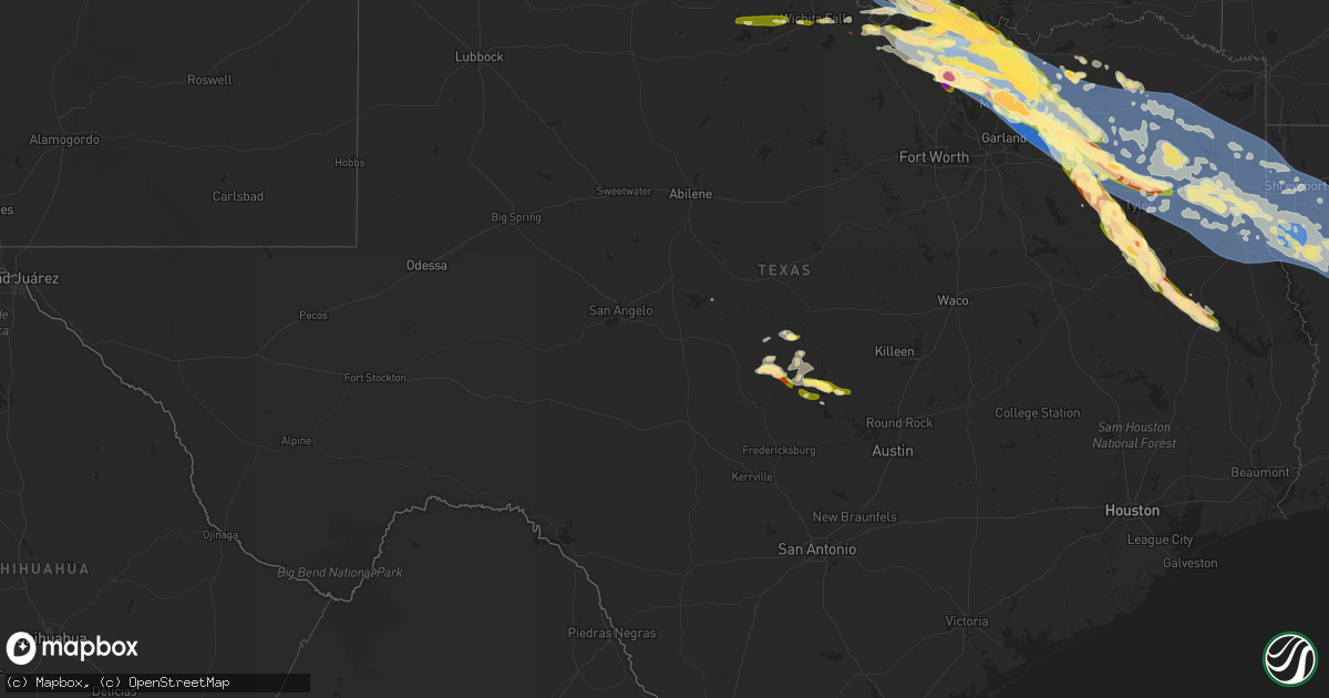
Hail Map in Texas on June 15, 2023
Get this storm
June 15 map
$229
one time, instant access
Download today. No call, no setup
Keep the $229
Bought the map and want the full workflow? Apply the entire $229 to a subscription within 7 days. None of it is wasted.
Every map, not just this one
This buys you this map. Subscription and you get every map we run, in the markets you choose from a few cities to whole states to nationwide. Plus real-time alerts the moment a storm fires.
Contact data
Name, contact info, occupancy, even credit band for addresses in the footprint. You go from where it hit to who to call.
Become the source they trust
Unlimited branding weather history reports on demand. You already have the documented answer ready for the property owner, and you are the one who showed up with it.
Property data and RoofTrace estimates
Pull up any address you have got, its value and the exact code rules for that jurisdiction, straight from One Click Code. Then RoofTrace estimates the squares, pitch, and roof value, priced the way you price.
Storm reports in Texas
Texas
| Date | Description |
|---|---|
| 06/15/20236:58 PM CDT | Quarter size hail in tow. |
| 06/15/20236:36 PM CDT | A local report indicates 2.50 inch wind near 5 S Higgins |
| 06/15/20236:33 PM CDT | A local report indicates 1.00 inch wind near 2 W Kamay |
| 06/15/20236:32 PM CDT | In tioga. Time estimated by radar. |
| 06/15/20236:32 PM CDT | A local report indicates 2.00 inch wind near Higgins |
| 06/15/20236:21 PM CDT | Via spotternetwork.org. |
| 06/15/20235:20 PM CDT | A local report indicates 1.25 inch wind near 2 N San Saba |
| 06/15/20235:10 PM CDT | Multiple reports of damage in perryton or the north side of downtown. |
| 06/15/20234:51 PM CDT | Via spotternetwork.org. |
| 06/15/20234:20 PM CDT | A local report indicates 1.25 inch wind near 4 NE Pontotoc |
| 06/15/20236:00 AM CDT | A tree was blown down across fm 843. |
| 06/15/20235:50 AM CDT | Quarter size hail fell near pollok. |
| 06/15/20235:24 AM CDT | Report from mping: half dollar |
| 06/15/20235:19 AM CDT | Report from mping: 3-inch tree limbs broken; power poles broken. |
| 06/15/20234:51 AM CDT | A picture was posted to social media of golfball size hail that fell in jacksonville. |
| 06/15/20234:48 AM CDT | Hen egg size hail fell on cr 4120 just northwest of jacksonville. |
| 06/15/20234:48 AM CDT | Golfball size hail fell just north of jacksonville. |
| 06/15/20234:48 AM CDT | Numerous trees and power lines down across northern cherokee county including jacksonville. |
| 06/15/20234:38 AM CDT | Quarter size hail fell in the mt. Selman community. |
| 06/15/20234:30 AM CDT | A picture of golfball size hail that fell near bullard was posted to social media. |
| 06/15/20234:19 AM CDT | Report of golf ball size hail in chandler. |
| 06/15/20234:14 AM CDT | Public report of quarter size hail just north of brownsboro. |
| 06/15/20233:50 AM CDT | Media report of golf ball size hail near the van/colfax area. |
| 06/15/20233:38 AM CDT | Several trees and power lines were downed across the county. |
| 06/15/20233:37 AM CDT | Nws survey team found damage in and around canton that was consistent with straight-line winds from the thunderstorms early on 6/16/23. Maximum speeds were 85 mph... Lo |
| 06/15/20233:09 AM CDT | Ktrl gusted to 55 kts at 0309am. |
| 06/15/20233:00 AM CDT | Numerous trees and power lines were downed in and around winona. |
| 06/15/20232:45 AM CDT | Nickel to quarter size hail in caddo mills. |
| 06/15/20232:22 AM CDT | Upgrade a previous report of quarter to ping pong ball size hail in ladonia. |
| 06/15/20232:20 AM CDT | A local report indicates 1.00 inch wind near 2 N Mineola |
| 06/15/20232:15 AM CDT | Hail up to ping pong size reported in the sand springs community between the town of mineola and community of golden. |
| 06/15/20232:15 AM CDT | Public report of quarter size hail in ladonia. |
| 06/15/20232:04 AM CDT | Public report of hail near alba via kltv-tv social media page. |
| 06/15/20231:45 AM CDT | Reports of multiple trees down across panola county... With many trees blocking road in the northern portion of the county. |
| 06/15/20231:35 AM CDT | A texas water development board mesonet site south of deberry... Tx... Called nansco farms... Recorded a 58 mph wind gust. |
| 06/15/20231:32 AM CDT | Public report of half dollar size hail north of sadler. |
| 06/15/20231:21 AM CDT | Emergency mngr reported golf ball size hail in gordonville. |
| 06/15/20231:16 AM CDT | Several large trees down in the panola area across us highway 79. |
| 06/15/20231:15 AM CDT | Reports of two structures with damage in the community of de berry. |
| 06/15/20231:15 AM CDT | An ef-1 tornado formed along a strong line of thunderstorms moving across east texas and northwest louisiana. The tornado first touched down in east texas on county roa |
| 06/15/20231:03 AM CDT | Public report of quarter size hail in sherman. |
| 06/15/20231:00 AM CDT | Reports of widespread trees down along with widespread power outages in the city of marshall. |
| 06/15/20231:00 AM CDT | A 63 mph wind gust was recorded at the east texas regional airport in longview. |
| 06/15/202312:52 AM CDT | Numerous trees and power lines down in marshall and throughout harrison county. About 880f harrison county is without power. |
| 06/15/202312:50 AM CDT | Numerous trees and utility poles down in the elderville area. |
| 06/15/202312:50 AM CDT | Trees down near the intersection of state highway 42 and county road 1115. |
| 06/15/202312:49 AM CDT | Numerous trees and power lines were downed throughout marion county. About 780f marion county is without power. |
| 06/15/202312:49 AM CDT | Public report of golf ball size hail in princeton. |
| 06/15/202312:45 AM CDT | Longview pd reports widespread snapped trees and utility poles across the city. |
| 06/15/202312:45 AM CDT | Trees down near the intersection of fm road 3053 and county road 1111. |
| 06/15/202312:41 AM CDT | Social media report of 2 inch hail in mckinney. |
| 06/15/202312:35 AM CDT | Trees down near intersection of hwy 271 and landry lane near the starrville community. |
| 06/15/202312:35 AM CDT | Report from mping: quarter |
| 06/15/202312:34 AM CDT | Report from mping: quarter |
| 06/15/202312:30 AM CDT | Reports of trees on a couple of homes in the town of lone star. |
| 06/15/202312:30 AM CDT | Numerous reports of large trees down across upshur county. |
| 06/15/202312:30 AM CDT | Trees down near the intersection of fm road 16 and county road 32. |
| 06/15/202312:26 AM CDT | Trees down at intersection of hwy 271 and county road 3110. |
| 06/15/202312:21 AM CDT | Report from mping: quarter |
| 06/15/202312:20 AM CDT | Reports of multiple trees down and blocking roads in camp county... Along with widespread power outages. |
| 06/15/202312:16 AM CDT | Multiple large hardwood trees uprooted. |
| 06/15/202312:15 AM CDT | A 69 mph wind gust was recorded at mount pleasant regional airport |
| 06/15/202312:10 AM CDT | A 10 x 15 porbable bulding blown over near the intersection of hwy 154 and kelsey road west of gilmer. |
| 06/15/202312:09 AM CDT | Golf ball size hail reported in pilot point. |
| 06/14/202311:47 PM CDT | Numerous trees and power lines down in the winnsboro area... Including some trees on homes. |
| 06/14/202311:43 PM CDT | Half dollar size hail. |
| 06/14/202311:40 PM CDT | [delayed report] personal weather station recorded 87 mph wind gust along hwy 11. |
| 06/14/202311:33 PM CDT | Corrects previous non-tstm wnd dmg report from 3 ese como. A nws survey team concluded that damage around como from the thunderstorms on 6/15/23 was consistent with a c |
| 06/14/202311:33 PM CDT | Delayed report - widespread wind damage between como and winnsboro. Powerlines down along with several trees and large tree branches. |
| 06/14/202311:33 PM CDT | Em reports quarter size hail in quinlan. |
| 06/14/202311:30 PM CDT | Delayed report: public report of golf ball size near cr-3613 just east of hawk cove. |
| 06/14/202311:05 PM CDT | Estimated 80mph wind gust in caddo mills. |
| 06/14/202310:55 PM CDT | Report from mping: half dollar |
| 06/14/202310:52 PM CDT | Em reports 78mph gust measured in lavon. |
| 06/14/202310:50 PM CDT | Several trees down and structural damage reported in lavon. |
| 06/14/202310:47 PM CDT | Quarter size hail reported in tioga. Time estimated by radar. |
| 06/14/202310:15 PM CDT | Em reports 2 in hail in blue ridge. |
| 06/14/202310:07 PM CDT | Tennis ball size hail reported on nw side of sanger near 35 via social media. |
| 06/14/20239:59 PM CDT | Ping pong size hail reported 2 miles north of bolivar. |
| 06/14/20239:57 PM CDT | Egg size hail reported on nw side of sanger. Time estimated by radar. |
| 06/14/20239:56 PM CDT | Photo of 5-5.5 inch hail in sanger. Time estimated by radar. |
| 06/14/20239:55 PM CDT | Ping pong size hail reported 6 miles w of sanger. |
| 06/14/20239:54 PM CDT | Quarter size hail reported 2 miles north of bolivar. |
| 06/14/20239:53 PM CDT | Social media and ham report of 3 inch hail nw of sanger. Time estimated by radar. |
| 06/14/20239:48 PM CDT | Quarter size hail reported 3 miles nw of muenster. |
| 06/14/20239:48 PM CDT | Fire department reports 30in diameter trees down in the 200 block of virginia avenue in whitesboro. Time estimated by radar. |
| 06/14/20239:45 PM CDT | Golf ball size hail reported in van alstyne. Time estimated by radar. |
| 06/14/20239:44 PM CDT | Em reports downed tree... Structure fire... And pump station power lost in anna. Time estimated by radar. |
| 06/14/20239:40 PM CDT | Emergency manager reports tree fell through the roof of an rv at the savoy rv park. Time estimated by radar. |
| 06/14/20239:36 PM CDT | Emergency manager reports golfball size hail between howe and van alstyne... Tx. |
| 06/14/20239:31 PM CDT | Corrects previous tstm wnd dmg report from sherman. Emergency manager reports 12in tree branches down in the city of sherman. Time estimated by radar. |
| 06/14/20239:31 PM CDT | Emergency manager reports trees down in the city of sherman. Time estimated by radar. |
| 06/14/20239:31 PM CDT | Em reports 2ft tree down on house west of fm1417 in sherman. Time estimated by radar. |
| 06/14/20239:15 PM CDT | Gainesville asos reports 66kt/76mph wind gust. |
| 06/14/20239:04 PM CDT | Ham reports quarter size hail 1 mile west of sadler... 1 mile north of 82. |
| 06/14/20238:53 PM CDT | Power lines down on highway 56 in southmayd. Time estimated by radar. |
| 06/14/20238:49 PM CDT | Fire chief reports ping pong size hail on old southmayd road south of highway 56. Time estimated by radar. |
| 06/14/20238:39 PM CDT | Quarter size hail reported 8 miles north of callisburg. |
| 06/14/20238:27 PM CDT | Quarter size hail reported in ringgold by vfd. |
| 06/14/20238:06 PM CDT | A local report indicates a tornado near 3 SSE Henrietta |
| 06/14/20237:50 PM CDT | Roof off building and power lines down just east of grand avenue on us-82 in gainesville. Time estimated by radar. |
| 06/14/20237:31 PM CDT | Report from mping half dollar. |
| 06/14/20237:30 PM CDT | Trained spotter reports quarter size hail in downtown burnet. Time estimated from radar. |
| 06/14/20237:29 PM CDT | Quarter size hail in burnet. |
| 06/14/20237:24 PM CDT | Twitter pic of quarter size hail four miles west of burnet. |
| 06/14/20237:17 PM CDT | Quarter size hail near lake buchanan. |
| 06/14/20237:15 PM CDT | A local report indicates 1.00 inch wind near 1 WSW Wichita Falls |
| 06/14/20237:05 PM CDT | Em reported golfball size hail at west moss lake. Time estimated by radar. |
All States Impacted by Hail Map on June 15, 2023
Cities Impacted by Hail Map on June 15, 2023
- Bell, FL
- Branford, FL
- Old Town, FL
- High Springs, FL
- Trenton, FL
- Alachua, FL
- Newberry, FL
- Archer, FL
- Williston, FL
- Gainesville, FL
- Micanopy, FL
- Bronson, FL
- Chiefland, FL
- Lena, MS
- Forest, MS
- Rolling Fork, MS
- Mayersville, MS
- Valley Park, MS
- Decatur, MS
- Conehatta, MS
- Vienna, GA
- Cordele, GA
- Daleville, MS
- Lauderdale, MS
- Meridian, MS
- Newellton, LA
- Port Gibson, MS
- Cairo, GA
- Cuba, AL
- Ward, AL
- York, AL
- Jennings, FL
- Lee, FL
- Pattison, MS
- Statenville, GA
- Lake Park, GA
- Fargo, GA
- Sweet Water, AL
- Dixons Mills, AL
- Union Church, MS
- Hazlehurst, MS
- Thomasville, AL
- Magnolia, AL
- Pine Hill, AL
- Camden, AL
- Catherine, AL
- Arlington, AL
- Thomaston, AL
- Brookhaven, MS
- McCall Creek, MS
- Bogue Chitto, MS
- Summit, MS
- Grove Hill, AL
- Hasty, CO
- Las Animas, CO
- Mccomb, MS
- Ruth, MS
- Whatley, AL
- Franklin, AL
- Tylertown, MS
- Buena Vista, GA
- Eutaw, AL
- Clayton, AL
- Clio, AL
- Ariton, AL
- Greenville, AL
- Baskin, LA
- Mangham, LA
- Rayville, LA
- Fort Deposit, AL
- Honoraville, AL
- Douglas, GA
- West Green, GA
- Broxton, GA
- Whigham, GA
- Canton, MS
- Hurtsboro, AL
- Safford, AL
- Jachin, AL
- Pennington, AL
- Louisville, AL
- Midway, AL
- Sardis, AL
- Minter, AL
- Madison, FL
- Shorterville, AL
- Toomsuba, MS
- Cottondale, AL
- Brookwood, AL
- Tuscaloosa, AL
- Linden, AL
- Preston, GA
- Walnut Grove, MS
- Demopolis, AL
- Eufaula, AL
- Pittsview, AL
- Hatchechubbee, AL
- Troy, AL
- Jack, AL
- Perry, FL
- Bailey, MS
- De Kalb, MS
- Carthage, MS
- Georgetown, GA
- Cuthbert, GA
- Morris, GA
- Meadville, MS
- Lorman, MS
- Oak Ridge, LA
- Quitman, GA
- Pinetta, FL
- Uniontown, AL
- Marion Junction, AL
- Monroe, LA
- Bainbridge, GA
- Climax, GA
- Sondheimer, LA
- Lake Providence, LA
- Vicksburg, MS
- Tallulah, LA
- Camden, MS
- Coy, AL
- Cobb, GA
- Arabi, GA
- De Soto, GA
- Dawson, GA
- Shellman, GA
- Hayneville, AL
- Taft, TX
- Union, MS
- Sebastopol, MS
- Richland, GA
- Weston, GA
- Kosciusko, MS
- Yazoo City, MS
- Jasper, FL
- Peterman, AL
- Monroeville, AL
- Pelham, GA
- Ochlocknee, GA
- Plains, GA
- Americus, GA
- Parrott, GA
- Smithville, GA
- Collinsville, MS
- Lumpkin, GA
- Skipperville, AL
- Ozark, AL
- Newville, AL
- Abbeville, AL
- Clopton, AL
- Hermanville, MS
- Wesson, MS
- Faunsdale, AL
- Alberta, AL
- Winnsboro, LA
- Delhi, LA
- Saint Joseph, LA
- Gallion, AL
- Bastrop, LA
- Valdosta, GA
- Philadelphia, MS
- Nicholls, GA
- Benton, MS
- Leslie, GA
- Weogufka, AL
- Lower Peach Tree, AL
- Lisman, AL
- Marion, MS
- Evergreen, AL
- Holly, CO
- Granada, CO
- McKenzie, AL
- Manter, KS
- Johnson, KS
- Syracuse, KS
- Saint Francis, KS
- Bird City, KS
- Ulysses, KS
- Atmore, AL
- Brewton, AL
- Willow, OK
- Mangum, OK
- Granite, OK
- Franklinton, LA
- Folsom, LA
- Covington, LA
- Lone Wolf, OK
- Bush, LA
- Lakin, KS
- Satanta, KS
- Mountain Park, OK
- Roosevelt, OK
- Cleveland, GA
- Helen, GA
- Sautee Nacoochee, GA
- Salem, SC
- Sunset, SC
- Six Mile, SC
- Hemingford, NE
- Alliance, NE
- Stratton, NE
- Healy, KS
- Dighton, KS
- Trenton, NE
- Dansville, MI
- Mason, MI
- Webberville, MI
- Williamston, MI
- Stockbridge, MI
- Fowlerville, MI
- Howell, MI
- Gregory, MI
- Lawton, OK
- Mountain View, OK
- Hobart, OK
- Gotebo, OK
- Ooltewah, TN
- Harrison, TN
- Pinckney, MI
- McDonald, TN
- Brighton, MI
- Whitmore Lake, MI
- Hamburg, MI
- Dexter, MI
- Merriman, NE
- Ann Arbor, MI
- Elgin, OK
- Medicine Park, OK
- San Saba, TX
- Cherokee, TX
- South Lyon, MI
- Hooker, OK
- Jay, FL
- Central, SC
- Liberty, SC
- Pendleton, SC
- Fort Sill, OK
- Ypsilanti, MI
- Northville, MI
- Plymouth, MI
- Marlow, OK
- Fletcher, OK
- Pontotoc, TX
- Willis, MI
- Belleville, MI
- New Boston, MI
- Carleton, MI
- Milan, MI
- Milton, FL
- Baker, FL
- Bluffton, IN
- Markle, IN
- Uniondale, IN
- Ossian, IN
- Lawrenceburg, TN
- Geneva, IN
- Decatur, IN
- Berne, IN
- Leoma, TN
- Indiahoma, OK
- Monroe, IN
- Canton, MI
- Duncan, OK
- Walters, OK
- Cache, OK
- Valley Spring, TX
- Llano, TX
- Faxon, OK
- Geronimo, OK
- Newport, MI
- Monroe, MI
- Erie, MI
- Temperance, MI
- Toledo, OH
- Luna Pier, MI
- Beaver, OK
- Bryant, IN
- Balko, OK
- Spearman, TX
- Oregon, OH
- Perryton, TX
- Booker, TX
- Comanche, OK
- Rolla, KS
- Elkhart, KS
- Tyrone, OK
- Ensign, KS
- Hugoton, KS
- Plains, KS
- Richfield, KS
- Kismet, KS
- Ingalls, KS
- Cimarron, KS
- Copeland, KS
- Sublette, KS
- Liberal, KS
- Dodge City, KS
- Moscow, KS
- Montezuma, KS
- Forgan, OK
- Fowler, KS
- Meade, KS
- Turpin, OK
- Englewood, KS
- Minneola, KS
- Wright, KS
- Romulus, MI
- Spearville, KS
- Ford, KS
- Bucklin, KS
- Canadian, TX
- Harbor View, OH
- Vernon, TX
- Electra, TX
- Anderson, SC
- Curtice, OH
- Oak Harbor, OH
- Martin, OH
- Graytown, OH
- Port Clinton, OH
- Loco, OK
- Waurika, OK
- Ryan, OK
- Lacarne, OH
- Elmore, OH
- Rocky Ridge, OH
- Fremont, OH
- Vickery, OH
- Hardesty, OK
- Follett, TX
- Darrouzett, TX
- Lipscomb, TX
- Higgins, TX
- Laverne, OK
- Ashland, KS
- Protection, KS
- Coldwater, KS
- Mullinville, KS
- Greensburg, KS
- Haviland, KS
- Offerle, KS
- Kinsley, KS
- Temple, OK
- Clyde, OH
- Lakeside Marblehead, OH
- Castalia, OH
- Sandusky, OH
- Iowa Park, TX
- Arnett, OK
- Shattuck, OK
- Deerfield, MI
- Petersburg, MI
- Dundee, MI
- Yuma, CO
- Stratton, CO
- Olney Springs, CO
- Calhan, CO
- Ellsworth, NE
- Cody, NE
- Cottonwood, AL
- Stockton, AL
- Cedar City, UT
- Kanarraville, UT
- Palisade, NE
- Gordon, NE
- Goodland, KS
- Amite, LA
- Loranger, LA
- Kit Carson, CO
- Murfreesboro, TN
- Beryl, UT
- Delta, UT
- Hugo, CO
- Ramah, CO
- Holcomb, KS
- Garden City, KS
- Ponte Vedra, FL
- Saint Augustine, FL
- Ponte Vedra Beach, FL
- Saline, MI
- Valentine, NE
- Tamassee, SC
- Mountain Rest, SC
- Hampshire, TN
- Summertown, TN
- Kanorado, KS
- Lamar, CO
- Beeler, KS
- Seibert, CO
- Ringgold, GA
- Red Level, AL
- Monticello, FL
- Flomaton, AL
- Soddy Daisy, TN
- Iuka, MS
- Husser, LA
- Springfield, CO
- Franklin, TN
- Kilgore, NE
- Whitney, NE
- Chadron, NE
- Eagleville, TN
- Rockvale, TN
- Jackson, AL
- Daytona Beach, FL
- Pansey, AL
- Ashford, AL
- Ormond Beach, FL
- Coffeeville, AL
- Toxey, AL
- Silas, AL
- Gilbertown, AL
- Sopchoppy, FL
- Carrabelle, FL
- Panacea, FL
- Opp, AL
- Gantt, AL
- Dozier, AL
- Andalusia, AL
- Wing, AL
- Moore Haven, FL
- Dothan, AL
- Hixson, TN
- Prospect, TN
- Little River, AL
- Smithdale, MS
- Bay Minette, AL
- Agate, CO
- Chattanooga, TN
- Signal Mountain, TN
- Springfield, LA
- Ponchatoula, LA
- Livingston, LA
- Kirk, CO
- Kinston, AL
- New Smyrna Beach, FL
- Tyler, AL
- Letohatchee, AL
- College Grove, TN
- Thompsons Station, TN
- Magnolia, MS
- Laurel Hill, FL
- Florala, AL
- Huron, TN
- Slocomb, AL
- Hartford, AL
- Samson, AL
- Westville, FL
- Burlington, CO
- Blissfield, MI
- Rush, CO
- Lamont, FL
- Greenville, FL
- Apison, TN
- Tunnel Hill, GA
- Cohutta, GA
- Hill City, KS
- Trinidad, CO
- Crawford, NE
- Century, FL
- Uriah, AL
- Hohenwald, TN
- Williamston, SC
- Geneva, AL
- Cherokee, AL
- Tishomingo, MS
- Perdido, AL
- Ethridge, TN
- Vona, CO
- Okeechobee, FL
- Earleton, FL
- Hawthorne, FL
- Melrose, FL
- Vredenburgh, AL
- Holden, LA
- La Place, LA
- Saint Stephens, AL
- Gainestown, AL
- Range, AL
- Castleberry, AL
- Lenox, AL
- Frisco City, AL
- Repton, AL
- Norris, SC
- Beatrice, AL
- Gordon, AL
- Ringling, OK
- Healdton, OK
- Wilmore, KS
- Lewis, KS
- Buchanan Dam, TX
- Bellevue, OH
- Monroeville, OH
- Nocona, TX
- Wilson, OK
- Sun City, KS
- Coats, KS
- Pratt, KS
- Sawyer, KS
- Belpre, KS
- Macksville, KS
- Byers, KS
- Lone Grove, OK
- Wichita Falls, TX
- Gould, OK
- Duke, OK
- Reydon, OK
- Durham, OK
- Norwalk, OH
- Crawford, OK
- Willard, OH
- New London, OH
- Hollis, OK
- Collins, OH
- Hydro, OK
- Overbrook, OK
- Ardmore, OK
- Marietta, OK
- Hinton, OK
- Greenwich, OH
- North Fairfield, OH
- Altus, OK
- Olustee, OK
- Blair, OK
- Vero Beach, FL
- Nova, OH
- Geary, OK
- Cheyenne, OK
- Calumet, OK
- Hammon, OK
- Wakeman, OH
- Shiloh, OH
- Tow, TX
- Thackerville, OK
- Burneyville, OK
- Gainesville, TX
- Bluffton, TX
- El Reno, OK
- Burnet, TX
- Ashland, OH
- Sullivan, OH
- Bertram, TX
- Headrick, OK
- Butler, OK
- Polk, OH
- West Salem, OH
- Union City, OK
- Sayre, OK
- Yukon, OK
- Sweetwater, OK
- Erick, OK
- Binger, OK
- Minco, OK
- Whitesboro, TX
- Leedey, OK
- Taloga, OK
- Jeromesville, OH
- Niceville, FL
- Freeport, FL
- Elk City, OK
- Santa Rosa Beach, FL
- Clinton, OK
- Henrietta, TX
- Vici, OK
- Camargo, OK
- Seiling, OK
- Mutual, OK
- Chester, OK
- Fairview, OK
- Longdale, OK
- Isabella, OK
- Okeene, OK
- Putnam, OK
- Arapaho, OK
- Tuttle, OK
- Carter, OK
- Cleo Springs, OK
- Ringwood, OK
- Meno, OK
- Goltry, OK
- Lahoma, OK
- Helena, OK
- Wooster, OH
- Burbank, OH
- Carrier, OK
- Drummond, OK
- Enid, OK
- Oakwood, OK
- Canton, OK
- Southard, OK
- Watonga, OK
- Smithville, OH
- Chattanooga, OK
- Blanchard, OK
- Newcastle, OK
- Chelsea, MI
- Norman, OK
- Oklahoma City, OK
- Dalton, OH
- Apple Creek, OH
- Orrville, OH
- Millersburg, OH
- Fredericksburg, OH
- Dundee, OH
- Wilmot, OH
- Mount Eaton, OH
- Navarre, OH
- Beach City, OH
- Washington, OK
- Sugarcreek, OH
- Strasburg, OH
- Noble, OK
- Amber, OK
- Macomb, OK
- Lexington, OK
- Hennessey, OK
- Bison, OK
- Dover, OK
- Crescent, OK
- Guthrie, OK
- Mulhall, OK
- Orlando, OK
- Marshall, OK
- Cashion, OK
- Okarche, OK
- Kingfisher, OK
- Piedmont, OK
- Edmond, OK
- Pensacola, FL
- Howe, TX
- Sherman, TX
- Gunter, TX
- Van Alstyne, TX
- Jones, OK
- Arcadia, OK
- Gulf Breeze, FL
- Anna, TX
- New Philadelphia, OH
- Dover, OH
- Stone Creek, OH
- Gnadenhutten, OH
- Tuscarawas, OH
- Uhrichsville, OH
- Dennison, OH
- Midvale, OH
- Tippecanoe, OH
- Port Washington, OH
- Freeport, OH
- Cadiz, OH
- Blue Ridge, TX
- Farmersville, TX
- Celeste, TX
- Sanger, TX
- Valley View, TX
- Denton, TX
- Saint Jo, TX
- Muenster, TX
- Lindsay, TX
- Tioga, TX
- Collinsville, TX
- Pilot Point, TX
- Fostoria, OH
- Tiffin, OH
- New Riegel, OH
- Bascom, OH
- Leon, OK
- Sadler, TX
- Era, TX
- Quinlan, TX
- Wills Point, TX
- Thedford, NE
- Gregory, SD
- Onida, SD
- Dalton, NE
- Livonia, MI
- Winner, SD
- Roggen, CO
- Lodgepole, NE
- Wellington, OH
- Hawk Springs, WY
- Garden City, MI
- Gettysburg, SD
- Harrold, SD
- Bucyrus, OH
- Saint Francis, SD
- Mission, SD
- Nenzel, NE
- Lisco, NE
- Oshkosh, NE
- Penokee, KS
- Dewy Rose, GA
- Grover, CO
- Conway Springs, KS
- Wellington, KS
- Clearwater, KS
- Lindsay, OK
- Halsey, NE
- North Baltimore, OH
- Holt, FL
- Woodville, OH
- Gibsonburg, OH
- Lindsey, OH
- Cedar Key, FL
- Buffalo, OK
- Fort Pierce, FL
- Berlin Heights, OH
- Milan, OH
- Carnegie, OK
- Jennings, KS
- Fort Cobb, OK
- Gate, OK
- Hamill, SD
- Cantonment, FL
- Rosston, TX
- Rockledge, FL
- Gage, OK
- Hartwell, GA
- Iva, SC
- Starr, SC
- Terral, OK
- Ida, MI
- Limon, CO
- Lookeba, OK
- Republic, OH
- Bushnell, NE
- McDavid, FL
- Ferguson, NC
- Stratford, OK
- Belton, SC
- Plymouth, OH
- Green Springs, OH
- Lindon, CO
- Akron, CO
- Shelby, OH
- Arcadia, OH
- Findlay, OH
- Freedom, OK
- Weatherford, OK
- Lorida, FL
- Edson, KS
- Elwood, NE
- Brush, CO
- Hillrose, CO
- Flat Rock, MI
- Rockwood, MI
- South Rockwood, MI
- Lester, AL
- Elkmont, AL
- Minor Hill, TN
- Banks, AL
- Crestview, FL
- Merino, CO
- Detroit, MI
- Maybee, MI
- Melbourne, FL
- Gouldbusk, TX
- Bloomville, OH
- Ringgold, TX
- Lillian, AL
- Bells, TX
- Pottsboro, TX
- Whitewright, TX
- Gordonville, TX
- Tom Bean, TX
- Bloomdale, OH
- Alvada, OH
- Morland, KS
- Ness City, KS
- Utica, KS
- Arnold, KS
- Ransom, KS
- Briggsdale, CO
- Snyder, OK
- Hastings, OK
- Denison, TX
- Corn, OK
- Deland, FL
- Lake Helen, FL
- Huntington, IN
- Horseshoe Beach, FL
- Melbourne Beach, FL
- Clewiston, FL
- Weldona, CO
- Baltic, OH
- Spring Hill, TN
- McComb, OH
- Otis, CO
- Eglin Afb, FL
- Fort Recovery, OH
- Coldwater, OH
- Celina, OH
- Bogue, KS
- Kingsland, TX
- Valparaiso, FL
- Montague, TX
- Robertsdale, AL
- Georgiana, AL
- Aubrey, TX
- Celina, TX
- Mckinney, TX
- Prosper, TX
- Lone Oak, TX
- Wylie, TX
- Saltillo, TX
- Pecan Gap, TX
- Mount Vernon, TX
- Emory, TX
- Campbell, TX
- Mount Pleasant, TX
- Point, TX
- Winnsboro, TX
- Princeton, TX
- Forestburg, TX
- Randolph, TX
- Little Elm, TX
- Lavon, TX
- Klondike, TX
- Royse City, TX
- Como, TX
- Pickton, TX
- Edgewood, TX
- Terrell, TX
- Cumby, TX
- Talco, TX
- Nevada, TX
- Leonard, TX
- Trenton, TX
- Greenville, TX
- Caddo Mills, TX
- Wolfe City, TX
- Brashear, TX
- Cooper, TX
- Yantis, TX
- Rockwall, TX
- Savoy, TX
- Commerce, TX
- Dike, TX
- Frisco, TX
- Ector, TX
- Allen, TX
- Bailey, TX
- Sulphur Bluff, TX
- Plano, TX
- Alba, TX
- Ladonia, TX
- Bonham, TX
- Melissa, TX
- Sulphur Springs, TX
- Grand Saline, TX
- Winfield, TX
- Quitman, TX
- Fruitvale, TX
- Naples, TX
- Hughes Springs, TX
- Daingerfield, TX
- Pittsburg, TX
- Leesburg, TX
- Scroggins, TX
- Omaha, TX
- Cookville, TX
- Ben Wheeler, TX
- Gilmer, TX
- Canton, TX
- Tyler, TX
- Van, TX
- Arp, TX
- Mineola, TX
- Lindale, TX
- Gladewater, TX
- Hawkins, TX
- Big Sandy, TX
- Ore City, TX
- Winona, TX
- Lone Star, TX
- Marietta, TX
- Linden, TX
- Harleton, TX
- Hallsville, TX
- Jefferson, TX
- Longview, TX
- Kilgore, TX
- Bivins, TX
- Diana, TX
- Overton, TX
- White Oak, TX
- Avinger, TX
- Karnack, TX
- Beckville, TX
- Henderson, TX
- De Berry, TX
- Marshall, TX
- Tatum, TX
- Carthage, TX
- Waskom, TX
- Long Branch, TX
- Timpson, TX
- Mount Enterprise, TX
- Gary, TX
- Vivian, LA
- Tenaha, TX
- Mooringsport, LA
- Center, TX
- Joaquin, TX
- Shreveport, LA
- Logansport, LA
- Blanchard, LA
- Keatchie, LA
- Greenwood, LA
- Bethany, LA
- Oil City, LA
- Keithville, LA
- Belcher, LA
- Grand Cane, LA
- Mansfield, LA
- Stonewall, LA
- Gloster, LA
- Bossier City, LA
- Benton, LA
- Frierson, LA
- Princeton, LA
- Barksdale Afb, LA
- Haughton, LA
- Athens, TX
- Eustace, TX
- Malakoff, TX
- Fairfield, TX
- Pelican, LA
- Elm Grove, LA
- Converse, LA
- Doyline, LA
- Coushatta, LA
- Pleasant Hill, LA
- Heflin, LA
- Sibley, LA
- Ringgold, LA
- Noble, LA
- Belmont, LA
- Hemphill, TX
- Zwolle, LA
- Many, LA
- Hall Summit, LA
- Robeline, LA
- Marthaville, LA
- Provencal, LA
- Natchitoches, LA
- Jamestown, LA
- Goldonna, LA
- Gibsland, LA
- Dodson, LA
- Bienville, LA
- Jonesboro, LA
- Castor, LA
- Campti, LA
- Dubberly, LA
- Quitman, LA
- Saline, LA
- Ashland, LA
- Atlanta, LA
- Winnfield, LA
- Cloutierville, LA
- Lena, LA
- Melrose, LA
- Montgomery, LA
- Natchez, LA
- Colfax, LA
- Georgetown, LA
- Tullos, LA
- Olla, LA
- Dry Prong, LA
- Trout, LA
- Pollock, LA
- Bentley, LA
- Mansfield, OH
- Brownsboro, TX
- Chandler, TX
- Bellville, OH
- Fredericktown, OH
- Perrysville, OH
- Loudonville, OH
- Lucas, OH
- Summerdale, AL
- Seminole, AL
- Elberta, AL
- Baltimore, OH
- Crestline, OH
- Murchison, TX
- Bowerston, OH
- Newcomerstown, OH
- Leesville, OH
- Sherrodsville, OH
- Lake Creek, TX
- Edgewater, FL
- Honey Grove, TX
- Bowie, TX
- Eads, CO
- Scio, OH
- Paris, TX
- Shreve, OH
- Adena, OH
- Attica, OH
- Holmesville, OH
- Howard, OH
- Sebastian, FL
- Mount Vernon, OH
- Butler, OH
- Danville, OH
- Gambier, OH
- Custar, OH
- Cygnet, OH
- Graham, OK
- Jewett, OH
- Cheyenne Wells, CO
- Grant, FL
- Kendall, KS
- Pierceville, KS
- Roxton, TX
- Marion, LA
- Decatur, TX
- Bellevue, TX
- Madill, OK
- Larue, TX
- Frankston, TX
- Bullard, TX
- Flint, TX
- Jacksonville, TX
- Palestine, TX
- Rusk, TX
- Troup, TX
- Alto, TX
- Wells, TX
- Douglass, TX
- Nacogdoches, TX
- Pollok, TX
- Lufkin, TX
- Livingston, TX
- Chester, TX
- Diboll, TX
- Corrigan, TX
- Huntington, TX
- Utica, MS
- Raymond, MS
- Clinton, MS
- Flowood, MS
- Bolton, MS
- Byram, MS
- Braxton, MS
- Edwards, MS
- Mendenhall, MS
- Jackson, MS
- Ridgeland, MS
- Pearl, MS
- Terry, MS
- Madison, MS
- Richland, MS
- Brandon, MS
- Florence, MS
- Tougaloo, MS
- Flora, MS
- Bentonia, MS
- Satartia, MS
- Redwood, MS
- Epps, LA
- Gilbert, LA
- Crystal Springs, MS
- Harrisville, MS
- Taylorsville, MS
- Raleigh, MS
- Mize, MS
- Collins, MS
- Magee, MS
- Pelahatchie, MS
- Seminary, MS
- Mount Olive, MS
- Moselle, MS
- Ellisville, MS
- Soso, MS
- Paulding, MS
- Chunky, MS
- Vossburg, MS
- Heidelberg, MS
- Hickory, MS
- Pulaski, MS
- Newton, MS
- Rose Hill, MS
- Lawrence, MS
- Morton, MS
- Stringer, MS
- Louin, MS
- Bay Springs, MS
- Enterprise, MS
- Laurel, MS
- Lake, MS
- Pachuta, MS
- Little Rock, MS
- Ovett, MS
- Shubuta, MS
- Waynesboro, MS
- Richton, MS
- Stonewall, MS
- Quitman, MS
- Petal, MS
- Buckatunna, MS
- Sicily Island, LA
- Wisner, LA
- Fort Necessity, LA
- Columbia, LA
- Clayton, LA
- Waterproof, LA
- Georgetown, MS
- Calhoun, LA
- Columbia, MS
- Bassfield, MS
- Carson, MS
- Lusk, WY
- Foley, AL
- New Augusta, MS
- Beaumont, MS
- Brooklyn, MS
- West Monroe, LA
- New Brockton, AL
- Transylvania, LA
- Pioneer, LA
- Cary, MS
- Wiggins, MS
- Hattiesburg, MS
- Richland Springs, TX
- Windom, TX
- Perkinston, MS
- Eros, LA
- Quinton, OK
- Mcalester, OK
- Wilburton, OK
- Lucedale, MS
- Whitehouse, TX
- Silverhill, AL
- Mustang, OK
- Wilmer, AL
- Mayo, FL
- Fort Pierre, SD
- Farmerville, LA
- Millersport, OH
- Newhebron, MS
- Prentiss, MS
- Sumrall, MS
- Oak Vale, MS
- Silver Creek, MS
- Purvis, MS
- Kimbolton, OH
- Monticello, MS
- Sontag, MS
- Pinola, MS
- Pelzer, SC


