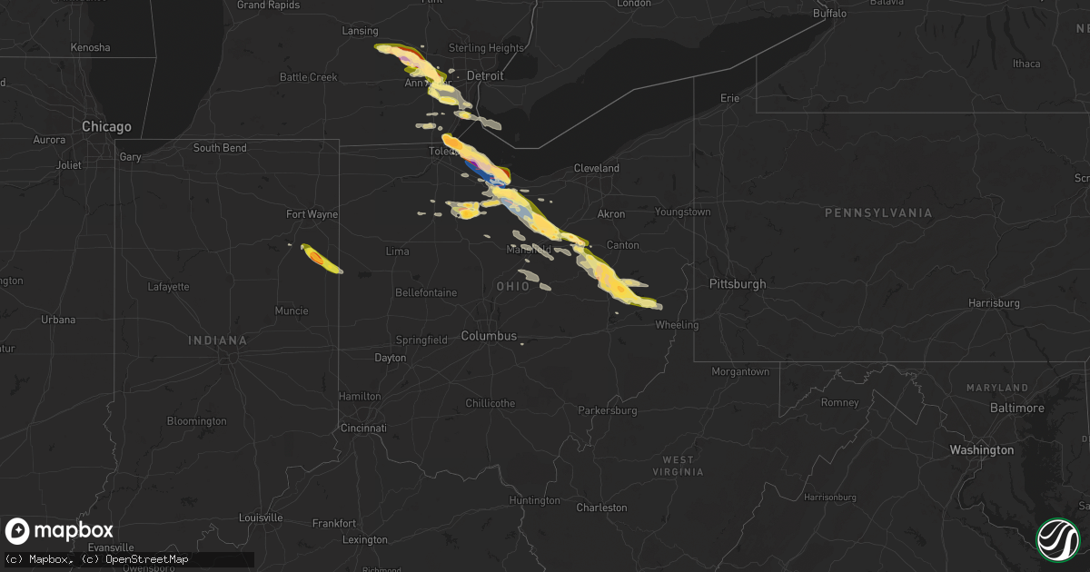
Hail Map in Ohio on June 15, 2023
Get this storm
June 15 map
$229
one time, instant access
Download today. No call, no setup
Keep the $229
Bought the map and want the full workflow? Apply the entire $229 to a subscription within 7 days. None of it is wasted.
Every map, not just this one
This buys you this map. Subscription and you get every map we run, in the markets you choose from a few cities to whole states to nationwide. Plus real-time alerts the moment a storm fires.
Contact data
Name, contact info, occupancy, even credit band for addresses in the footprint. You go from where it hit to who to call.
Become the source they trust
Unlimited branding weather history reports on demand. You already have the documented answer ready for the property owner, and you are the one who showed up with it.
Property data and RoofTrace estimates
Pull up any address you have got, its value and the exact code rules for that jurisdiction, straight from One Click Code. Then RoofTrace estimates the squares, pitch, and roof value, priced the way you price.
Storm reports in Ohio
Ohio
| Date | Description |
|---|---|
| 06/15/20236:55 PM CDT | Metal barn partially destroyed on ridge road. |
| 06/15/20236:53 PM CDT | Damage to houses and outbuildings. Numerous trees and powerlines down. Possible tornado damage. Time estimated via radar. |
| 06/15/20236:53 PM CDT | A local report indicates 1.00 inch wind near Tiffin |
| 06/15/20236:52 PM CDT | Golf ball sized hail between bascom and tiffin. |
| 06/15/20236:52 PM CDT | Report from mping: half dollar |
| 06/15/20236:51 PM CDT | Large tree uprooted. Time estimated via radar. |
| 06/15/20236:51 PM CDT | Multiple trees down north of bellevue. Report obtained on social media and time estimated via radar. |
| 06/15/20236:49 PM CDT | Trained spotter reported quarter sized hail in bascom. |
| 06/15/20236:40 PM CDT | Large trees downed just north of bellevue. Time estimated via radar. |
| 06/15/20236:32 PM CDT | A trained spotter reported golf ball sized hail near sr 269 and lincoln street in bellevue. |
| 06/15/20236:31 PM CDT | Corrects previous non-tstm wnd dmg report from bellevue. Trees snapped along northwest street. |
| 06/15/20236:29 PM CDT | A local report indicates 1.50 inch wind near 1 W Bellevue |
| 06/15/20236:29 PM CDT | A local report indicates 1.75 inch wind near Bellevue |
| 06/15/20236:27 PM CDT | Barn collapse. Time estimated via radar. |
| 06/15/20236:27 PM CDT | Numerous trees and powerlines down. |
| 06/15/20236:22 PM CDT | Corrects previous non-tstm wnd dmg report from 2 wsw sandusky. Poles snapped along us-6. |
| 06/15/20236:20 PM CDT | Outbuilding destroyed with debris scattered into field near us-6 and county road 298. Time estimated via radar. |
| 06/15/20236:18 PM CDT | Multiple trees snapped and powerlines down along the turnpike/i-80. Time estimated via radar. |
| 06/15/20235:57 PM CDT | Several reports of structural damage along and around state route 19 south of oak harbor in ottawa county. Damage includes siding damage... Outbuilding wall failure... |
| 06/15/20235:52 PM CDT | Corrects time on previous report from 6 se oak harbor. Emergency manager reported storm damage in rice twp. Possible tornado. |
| 06/15/20235:50 PM CDT | Damage to multiple houses near hetrick and bloom roads. Possible tornado damage. |
| 06/15/20235:50 PM CDT | Damage to vehicles and farm buildings. Pictures via social media. Possible tornado damage. |
| 06/15/20235:49 PM CDT | Preliminary nws storm survey determined an ef-2 tornado with estimated peak winds of 130 mph and a path width of 200 yards occurred south of oak harbor in ottawa county |
| 06/15/20235:48 PM CDT | Time estimated via radar. |
| 06/15/20235:42 PM CDT | A local report indicates 1.25 inch wind near 6 NNE Rocky Ridge |
| 06/15/20235:18 PM CDT | C-man station thro1 toledo... Oh reported a 57 kt wind gust. |
| 06/15/20235:18 PM CDT | Buoy station thro1 toledo... Oh. |
| 06/15/20235:16 PM CDT | Numerous large trees snapped and damage to a building. Possible tornado damage. |
| 06/15/20235:16 PM CDT | Time estimated via radar. |
| 06/15/20235:15 PM CDT | Report from mping: tennis ball |
| 06/15/20235:15 PM CDT | A local report indicates 2.00 inch wind near 3 NW Harbor View |
| 06/15/20235:10 PM CDT | Numerous trees snapped. Minor damage to a vehicle reported as well as minor damage to a roof. Time estimated via radar. |
| 06/15/20235:10 PM CDT | Large hail reported in maumee bay state park. Time estimated via radar. |
| 06/15/20235:09 PM CDT | Numerous reports of trees snapped and structural damage... Including roofs ripped off buildings... In point place. Possible tornado. |
| 06/15/20235:07 PM CDT | Multiple utility poles down and report of a roof blown off of a house in washington township. Time estimated via radar. |
| 06/15/20235:06 PM CDT | Preliminary nws storm survey determined an ef-2 tornado with estimated peak winds of 130 mph and path width of 300 yards occurred in lucas county... Oh. The tornado tou |
| 06/14/202310:41 PM CDT | A few trees down on county road 12. |
| 06/14/202310:37 PM CDT | Department of transportation reporting downed trees along state route 9 near new athens. |
| 06/14/202310:32 PM CDT | A local report indicates 1.00 inch wind near Cadiz |
| 06/14/202310:06 PM CDT | Time estimated from radar |
| 06/14/20239:55 PM CDT | A local report indicates 1.00 inch wind near Uhrichsville |
| 06/14/20239:51 PM CDT | Estimated size and time estimated based on radar. |
| 06/14/20239:50 PM CDT | Numerous trees and tree limbs down in bexley - time estimated by radar. |
| 06/14/20239:49 PM CDT | A local report indicates 1.00 inch wind near Gnadenhutten |
| 06/14/20239:47 PM CDT | A local report indicates 1.25 inch wind near Tuscarawas |
| 06/14/20239:40 PM CDT | A local report indicates 1.00 inch wind near New Philadelphia |
| 06/14/20239:39 PM CDT | A local report indicates 1.00 inch wind near New Philadelphia |
| 06/14/20239:35 PM CDT | A local report indicates 1.00 inch wind near 2 S Stone Creek |
| 06/14/20239:31 PM CDT | A local report indicates 1.25 inch wind near 1 W Dover |
| 06/14/20239:25 PM CDT | A local report indicates 1.00 inch wind near 5 WNW Dover |
| 06/14/20239:25 PM CDT | Tree down. |
| 06/14/20239:12 PM CDT | Two trees downed on property southwest of bellville. Time estimated via radar. |
| 06/14/20238:49 PM CDT | Emergency management reported storm damage in rice twp. Possible tornado. Time estimated via radar. |
| 06/14/20238:36 PM CDT | Large tree down on route 39. |
| 06/14/20238:30 PM CDT | Corrects previous non-tstm wnd dmg report from 2 ese crestline. Tree reported down on north horning road. |
| 06/14/20238:25 PM CDT | Reported via photo on social media. Time estimated via radar. |
| 06/14/20238:20 PM CDT | Tree down on mechanicsburg road. |
| 06/14/20238:16 PM CDT | Tree down on south firestone road. |
| 06/14/20238:15 PM CDT | Tree down. |
| 06/14/20238:14 PM CDT | Tree downed across smithville western road in chester twp. Time estimated via radar. |
| 06/14/20237:50 PM CDT | Numerous trees down along sr 58 between county rd 801 and 852. |
| 06/14/20237:50 PM CDT | A local report indicates 1.75 inch wind near 3 SW Polk |
| 06/14/20237:49 PM CDT | Report from mping: golf ball |
| 06/14/20237:47 PM CDT | Preliminary nws storm survey determined an ef-0 tornado with estimated winds of 85 mph and an estimated width of 300 yards touched down 1 mile north-northeast of nankin |
| 06/14/20237:46 PM CDT | Time estimated via radar. |
| 06/14/20237:37 PM CDT | Picture submitted via social media. |
| 06/14/20237:35 PM CDT | Report from mping: half dollar |
| 06/14/20237:32 PM CDT | Several trees down. |
| 06/14/20237:32 PM CDT | Tree down on house. |
| 06/14/20237:32 PM CDT | A local report indicates 1.75 inch wind near Savannah |
| 06/14/20237:06 PM CDT | Report from mping: quarter |
| 06/14/20237:04 PM CDT | Corrects previous non-tstm wnd dmg report from 3 se north fairfield. House damaged on edward road. |
All States Impacted by Hail Map on June 15, 2023
Cities Impacted by Hail Map on June 15, 2023
- Bell, FL
- Branford, FL
- Old Town, FL
- High Springs, FL
- Trenton, FL
- Alachua, FL
- Newberry, FL
- Archer, FL
- Williston, FL
- Gainesville, FL
- Micanopy, FL
- Bronson, FL
- Chiefland, FL
- Lena, MS
- Forest, MS
- Rolling Fork, MS
- Mayersville, MS
- Valley Park, MS
- Decatur, MS
- Conehatta, MS
- Vienna, GA
- Cordele, GA
- Daleville, MS
- Lauderdale, MS
- Meridian, MS
- Newellton, LA
- Port Gibson, MS
- Cairo, GA
- Cuba, AL
- Ward, AL
- York, AL
- Jennings, FL
- Lee, FL
- Pattison, MS
- Statenville, GA
- Lake Park, GA
- Fargo, GA
- Sweet Water, AL
- Dixons Mills, AL
- Union Church, MS
- Hazlehurst, MS
- Thomasville, AL
- Magnolia, AL
- Pine Hill, AL
- Camden, AL
- Catherine, AL
- Arlington, AL
- Thomaston, AL
- Brookhaven, MS
- McCall Creek, MS
- Bogue Chitto, MS
- Summit, MS
- Grove Hill, AL
- Hasty, CO
- Las Animas, CO
- Mccomb, MS
- Ruth, MS
- Whatley, AL
- Franklin, AL
- Tylertown, MS
- Buena Vista, GA
- Eutaw, AL
- Clayton, AL
- Clio, AL
- Ariton, AL
- Greenville, AL
- Baskin, LA
- Mangham, LA
- Rayville, LA
- Fort Deposit, AL
- Honoraville, AL
- Douglas, GA
- West Green, GA
- Broxton, GA
- Whigham, GA
- Canton, MS
- Hurtsboro, AL
- Safford, AL
- Jachin, AL
- Pennington, AL
- Louisville, AL
- Midway, AL
- Sardis, AL
- Minter, AL
- Madison, FL
- Shorterville, AL
- Toomsuba, MS
- Cottondale, AL
- Brookwood, AL
- Tuscaloosa, AL
- Linden, AL
- Preston, GA
- Walnut Grove, MS
- Demopolis, AL
- Eufaula, AL
- Pittsview, AL
- Hatchechubbee, AL
- Troy, AL
- Jack, AL
- Perry, FL
- Bailey, MS
- De Kalb, MS
- Carthage, MS
- Georgetown, GA
- Cuthbert, GA
- Morris, GA
- Meadville, MS
- Lorman, MS
- Oak Ridge, LA
- Quitman, GA
- Pinetta, FL
- Uniontown, AL
- Marion Junction, AL
- Monroe, LA
- Bainbridge, GA
- Climax, GA
- Sondheimer, LA
- Lake Providence, LA
- Vicksburg, MS
- Tallulah, LA
- Camden, MS
- Coy, AL
- Cobb, GA
- Arabi, GA
- De Soto, GA
- Dawson, GA
- Shellman, GA
- Hayneville, AL
- Taft, TX
- Union, MS
- Sebastopol, MS
- Richland, GA
- Weston, GA
- Kosciusko, MS
- Yazoo City, MS
- Jasper, FL
- Peterman, AL
- Monroeville, AL
- Pelham, GA
- Ochlocknee, GA
- Plains, GA
- Americus, GA
- Parrott, GA
- Smithville, GA
- Collinsville, MS
- Lumpkin, GA
- Skipperville, AL
- Ozark, AL
- Newville, AL
- Abbeville, AL
- Clopton, AL
- Hermanville, MS
- Wesson, MS
- Faunsdale, AL
- Alberta, AL
- Winnsboro, LA
- Delhi, LA
- Saint Joseph, LA
- Gallion, AL
- Bastrop, LA
- Valdosta, GA
- Philadelphia, MS
- Nicholls, GA
- Benton, MS
- Leslie, GA
- Weogufka, AL
- Lower Peach Tree, AL
- Lisman, AL
- Marion, MS
- Evergreen, AL
- Holly, CO
- Granada, CO
- McKenzie, AL
- Manter, KS
- Johnson, KS
- Syracuse, KS
- Saint Francis, KS
- Bird City, KS
- Ulysses, KS
- Atmore, AL
- Brewton, AL
- Willow, OK
- Mangum, OK
- Granite, OK
- Franklinton, LA
- Folsom, LA
- Covington, LA
- Lone Wolf, OK
- Bush, LA
- Lakin, KS
- Satanta, KS
- Mountain Park, OK
- Roosevelt, OK
- Cleveland, GA
- Helen, GA
- Sautee Nacoochee, GA
- Salem, SC
- Sunset, SC
- Six Mile, SC
- Hemingford, NE
- Alliance, NE
- Stratton, NE
- Healy, KS
- Dighton, KS
- Trenton, NE
- Dansville, MI
- Mason, MI
- Webberville, MI
- Williamston, MI
- Stockbridge, MI
- Fowlerville, MI
- Howell, MI
- Gregory, MI
- Lawton, OK
- Mountain View, OK
- Hobart, OK
- Gotebo, OK
- Ooltewah, TN
- Harrison, TN
- Pinckney, MI
- McDonald, TN
- Brighton, MI
- Whitmore Lake, MI
- Hamburg, MI
- Dexter, MI
- Merriman, NE
- Ann Arbor, MI
- Elgin, OK
- Medicine Park, OK
- San Saba, TX
- Cherokee, TX
- South Lyon, MI
- Hooker, OK
- Jay, FL
- Central, SC
- Liberty, SC
- Pendleton, SC
- Fort Sill, OK
- Ypsilanti, MI
- Northville, MI
- Plymouth, MI
- Marlow, OK
- Fletcher, OK
- Pontotoc, TX
- Willis, MI
- Belleville, MI
- New Boston, MI
- Carleton, MI
- Milan, MI
- Milton, FL
- Baker, FL
- Bluffton, IN
- Markle, IN
- Uniondale, IN
- Ossian, IN
- Lawrenceburg, TN
- Geneva, IN
- Decatur, IN
- Berne, IN
- Leoma, TN
- Indiahoma, OK
- Monroe, IN
- Canton, MI
- Duncan, OK
- Walters, OK
- Cache, OK
- Valley Spring, TX
- Llano, TX
- Faxon, OK
- Geronimo, OK
- Newport, MI
- Monroe, MI
- Erie, MI
- Temperance, MI
- Toledo, OH
- Luna Pier, MI
- Beaver, OK
- Bryant, IN
- Balko, OK
- Spearman, TX
- Oregon, OH
- Perryton, TX
- Booker, TX
- Comanche, OK
- Rolla, KS
- Elkhart, KS
- Tyrone, OK
- Ensign, KS
- Hugoton, KS
- Plains, KS
- Richfield, KS
- Kismet, KS
- Ingalls, KS
- Cimarron, KS
- Copeland, KS
- Sublette, KS
- Liberal, KS
- Dodge City, KS
- Moscow, KS
- Montezuma, KS
- Forgan, OK
- Fowler, KS
- Meade, KS
- Turpin, OK
- Englewood, KS
- Minneola, KS
- Wright, KS
- Romulus, MI
- Spearville, KS
- Ford, KS
- Bucklin, KS
- Canadian, TX
- Harbor View, OH
- Vernon, TX
- Electra, TX
- Anderson, SC
- Curtice, OH
- Oak Harbor, OH
- Martin, OH
- Graytown, OH
- Port Clinton, OH
- Loco, OK
- Waurika, OK
- Ryan, OK
- Lacarne, OH
- Elmore, OH
- Rocky Ridge, OH
- Fremont, OH
- Vickery, OH
- Hardesty, OK
- Follett, TX
- Darrouzett, TX
- Lipscomb, TX
- Higgins, TX
- Laverne, OK
- Ashland, KS
- Protection, KS
- Coldwater, KS
- Mullinville, KS
- Greensburg, KS
- Haviland, KS
- Offerle, KS
- Kinsley, KS
- Temple, OK
- Clyde, OH
- Lakeside Marblehead, OH
- Castalia, OH
- Sandusky, OH
- Iowa Park, TX
- Arnett, OK
- Shattuck, OK
- Deerfield, MI
- Petersburg, MI
- Dundee, MI
- Yuma, CO
- Stratton, CO
- Olney Springs, CO
- Calhan, CO
- Ellsworth, NE
- Cody, NE
- Cottonwood, AL
- Stockton, AL
- Cedar City, UT
- Kanarraville, UT
- Palisade, NE
- Gordon, NE
- Goodland, KS
- Amite, LA
- Loranger, LA
- Kit Carson, CO
- Murfreesboro, TN
- Beryl, UT
- Delta, UT
- Hugo, CO
- Ramah, CO
- Holcomb, KS
- Garden City, KS
- Ponte Vedra, FL
- Saint Augustine, FL
- Ponte Vedra Beach, FL
- Saline, MI
- Valentine, NE
- Tamassee, SC
- Mountain Rest, SC
- Hampshire, TN
- Summertown, TN
- Kanorado, KS
- Lamar, CO
- Beeler, KS
- Seibert, CO
- Ringgold, GA
- Red Level, AL
- Monticello, FL
- Flomaton, AL
- Soddy Daisy, TN
- Iuka, MS
- Husser, LA
- Springfield, CO
- Franklin, TN
- Kilgore, NE
- Whitney, NE
- Chadron, NE
- Eagleville, TN
- Rockvale, TN
- Jackson, AL
- Daytona Beach, FL
- Pansey, AL
- Ashford, AL
- Ormond Beach, FL
- Coffeeville, AL
- Toxey, AL
- Silas, AL
- Gilbertown, AL
- Sopchoppy, FL
- Carrabelle, FL
- Panacea, FL
- Opp, AL
- Gantt, AL
- Dozier, AL
- Andalusia, AL
- Wing, AL
- Moore Haven, FL
- Dothan, AL
- Hixson, TN
- Prospect, TN
- Little River, AL
- Smithdale, MS
- Bay Minette, AL
- Agate, CO
- Chattanooga, TN
- Signal Mountain, TN
- Springfield, LA
- Ponchatoula, LA
- Livingston, LA
- Kirk, CO
- Kinston, AL
- New Smyrna Beach, FL
- Tyler, AL
- Letohatchee, AL
- College Grove, TN
- Thompsons Station, TN
- Magnolia, MS
- Laurel Hill, FL
- Florala, AL
- Huron, TN
- Slocomb, AL
- Hartford, AL
- Samson, AL
- Westville, FL
- Burlington, CO
- Blissfield, MI
- Rush, CO
- Lamont, FL
- Greenville, FL
- Apison, TN
- Tunnel Hill, GA
- Cohutta, GA
- Hill City, KS
- Trinidad, CO
- Crawford, NE
- Century, FL
- Uriah, AL
- Hohenwald, TN
- Williamston, SC
- Geneva, AL
- Cherokee, AL
- Tishomingo, MS
- Perdido, AL
- Ethridge, TN
- Vona, CO
- Okeechobee, FL
- Earleton, FL
- Hawthorne, FL
- Melrose, FL
- Vredenburgh, AL
- Holden, LA
- La Place, LA
- Saint Stephens, AL
- Gainestown, AL
- Range, AL
- Castleberry, AL
- Lenox, AL
- Frisco City, AL
- Repton, AL
- Norris, SC
- Beatrice, AL
- Gordon, AL
- Ringling, OK
- Healdton, OK
- Wilmore, KS
- Lewis, KS
- Buchanan Dam, TX
- Bellevue, OH
- Monroeville, OH
- Nocona, TX
- Wilson, OK
- Sun City, KS
- Coats, KS
- Pratt, KS
- Sawyer, KS
- Belpre, KS
- Macksville, KS
- Byers, KS
- Lone Grove, OK
- Wichita Falls, TX
- Gould, OK
- Duke, OK
- Reydon, OK
- Durham, OK
- Norwalk, OH
- Crawford, OK
- Willard, OH
- New London, OH
- Hollis, OK
- Collins, OH
- Hydro, OK
- Overbrook, OK
- Ardmore, OK
- Marietta, OK
- Hinton, OK
- Greenwich, OH
- North Fairfield, OH
- Altus, OK
- Olustee, OK
- Blair, OK
- Vero Beach, FL
- Nova, OH
- Geary, OK
- Cheyenne, OK
- Calumet, OK
- Hammon, OK
- Wakeman, OH
- Shiloh, OH
- Tow, TX
- Thackerville, OK
- Burneyville, OK
- Gainesville, TX
- Bluffton, TX
- El Reno, OK
- Burnet, TX
- Ashland, OH
- Sullivan, OH
- Bertram, TX
- Headrick, OK
- Butler, OK
- Polk, OH
- West Salem, OH
- Union City, OK
- Sayre, OK
- Yukon, OK
- Sweetwater, OK
- Erick, OK
- Binger, OK
- Minco, OK
- Whitesboro, TX
- Leedey, OK
- Taloga, OK
- Jeromesville, OH
- Niceville, FL
- Freeport, FL
- Elk City, OK
- Santa Rosa Beach, FL
- Clinton, OK
- Henrietta, TX
- Vici, OK
- Camargo, OK
- Seiling, OK
- Mutual, OK
- Chester, OK
- Fairview, OK
- Longdale, OK
- Isabella, OK
- Okeene, OK
- Putnam, OK
- Arapaho, OK
- Tuttle, OK
- Carter, OK
- Cleo Springs, OK
- Ringwood, OK
- Meno, OK
- Goltry, OK
- Lahoma, OK
- Helena, OK
- Wooster, OH
- Burbank, OH
- Carrier, OK
- Drummond, OK
- Enid, OK
- Oakwood, OK
- Canton, OK
- Southard, OK
- Watonga, OK
- Smithville, OH
- Chattanooga, OK
- Blanchard, OK
- Newcastle, OK
- Chelsea, MI
- Norman, OK
- Oklahoma City, OK
- Dalton, OH
- Apple Creek, OH
- Orrville, OH
- Millersburg, OH
- Fredericksburg, OH
- Dundee, OH
- Wilmot, OH
- Mount Eaton, OH
- Navarre, OH
- Beach City, OH
- Washington, OK
- Sugarcreek, OH
- Strasburg, OH
- Noble, OK
- Amber, OK
- Macomb, OK
- Lexington, OK
- Hennessey, OK
- Bison, OK
- Dover, OK
- Crescent, OK
- Guthrie, OK
- Mulhall, OK
- Orlando, OK
- Marshall, OK
- Cashion, OK
- Okarche, OK
- Kingfisher, OK
- Piedmont, OK
- Edmond, OK
- Pensacola, FL
- Howe, TX
- Sherman, TX
- Gunter, TX
- Van Alstyne, TX
- Jones, OK
- Arcadia, OK
- Gulf Breeze, FL
- Anna, TX
- New Philadelphia, OH
- Dover, OH
- Stone Creek, OH
- Gnadenhutten, OH
- Tuscarawas, OH
- Uhrichsville, OH
- Dennison, OH
- Midvale, OH
- Tippecanoe, OH
- Port Washington, OH
- Freeport, OH
- Cadiz, OH
- Blue Ridge, TX
- Farmersville, TX
- Celeste, TX
- Sanger, TX
- Valley View, TX
- Denton, TX
- Saint Jo, TX
- Muenster, TX
- Lindsay, TX
- Tioga, TX
- Collinsville, TX
- Pilot Point, TX
- Fostoria, OH
- Tiffin, OH
- New Riegel, OH
- Bascom, OH
- Leon, OK
- Sadler, TX
- Era, TX
- Quinlan, TX
- Wills Point, TX
- Thedford, NE
- Gregory, SD
- Onida, SD
- Dalton, NE
- Livonia, MI
- Winner, SD
- Roggen, CO
- Lodgepole, NE
- Wellington, OH
- Hawk Springs, WY
- Garden City, MI
- Gettysburg, SD
- Harrold, SD
- Bucyrus, OH
- Saint Francis, SD
- Mission, SD
- Nenzel, NE
- Lisco, NE
- Oshkosh, NE
- Penokee, KS
- Dewy Rose, GA
- Grover, CO
- Conway Springs, KS
- Wellington, KS
- Clearwater, KS
- Lindsay, OK
- Halsey, NE
- North Baltimore, OH
- Holt, FL
- Woodville, OH
- Gibsonburg, OH
- Lindsey, OH
- Cedar Key, FL
- Buffalo, OK
- Fort Pierce, FL
- Berlin Heights, OH
- Milan, OH
- Carnegie, OK
- Jennings, KS
- Fort Cobb, OK
- Gate, OK
- Hamill, SD
- Cantonment, FL
- Rosston, TX
- Rockledge, FL
- Gage, OK
- Hartwell, GA
- Iva, SC
- Starr, SC
- Terral, OK
- Ida, MI
- Limon, CO
- Lookeba, OK
- Republic, OH
- Bushnell, NE
- McDavid, FL
- Ferguson, NC
- Stratford, OK
- Belton, SC
- Plymouth, OH
- Green Springs, OH
- Lindon, CO
- Akron, CO
- Shelby, OH
- Arcadia, OH
- Findlay, OH
- Freedom, OK
- Weatherford, OK
- Lorida, FL
- Edson, KS
- Elwood, NE
- Brush, CO
- Hillrose, CO
- Flat Rock, MI
- Rockwood, MI
- South Rockwood, MI
- Lester, AL
- Elkmont, AL
- Minor Hill, TN
- Banks, AL
- Crestview, FL
- Merino, CO
- Detroit, MI
- Maybee, MI
- Melbourne, FL
- Gouldbusk, TX
- Bloomville, OH
- Ringgold, TX
- Lillian, AL
- Bells, TX
- Pottsboro, TX
- Whitewright, TX
- Gordonville, TX
- Tom Bean, TX
- Bloomdale, OH
- Alvada, OH
- Morland, KS
- Ness City, KS
- Utica, KS
- Arnold, KS
- Ransom, KS
- Briggsdale, CO
- Snyder, OK
- Hastings, OK
- Denison, TX
- Corn, OK
- Deland, FL
- Lake Helen, FL
- Huntington, IN
- Horseshoe Beach, FL
- Melbourne Beach, FL
- Clewiston, FL
- Weldona, CO
- Baltic, OH
- Spring Hill, TN
- McComb, OH
- Otis, CO
- Eglin Afb, FL
- Fort Recovery, OH
- Coldwater, OH
- Celina, OH
- Bogue, KS
- Kingsland, TX
- Valparaiso, FL
- Montague, TX
- Robertsdale, AL
- Georgiana, AL
- Aubrey, TX
- Celina, TX
- Mckinney, TX
- Prosper, TX
- Lone Oak, TX
- Wylie, TX
- Saltillo, TX
- Pecan Gap, TX
- Mount Vernon, TX
- Emory, TX
- Campbell, TX
- Mount Pleasant, TX
- Point, TX
- Winnsboro, TX
- Princeton, TX
- Forestburg, TX
- Randolph, TX
- Little Elm, TX
- Lavon, TX
- Klondike, TX
- Royse City, TX
- Como, TX
- Pickton, TX
- Edgewood, TX
- Terrell, TX
- Cumby, TX
- Talco, TX
- Nevada, TX
- Leonard, TX
- Trenton, TX
- Greenville, TX
- Caddo Mills, TX
- Wolfe City, TX
- Brashear, TX
- Cooper, TX
- Yantis, TX
- Rockwall, TX
- Savoy, TX
- Commerce, TX
- Dike, TX
- Frisco, TX
- Ector, TX
- Allen, TX
- Bailey, TX
- Sulphur Bluff, TX
- Plano, TX
- Alba, TX
- Ladonia, TX
- Bonham, TX
- Melissa, TX
- Sulphur Springs, TX
- Grand Saline, TX
- Winfield, TX
- Quitman, TX
- Fruitvale, TX
- Naples, TX
- Hughes Springs, TX
- Daingerfield, TX
- Pittsburg, TX
- Leesburg, TX
- Scroggins, TX
- Omaha, TX
- Cookville, TX
- Ben Wheeler, TX
- Gilmer, TX
- Canton, TX
- Tyler, TX
- Van, TX
- Arp, TX
- Mineola, TX
- Lindale, TX
- Gladewater, TX
- Hawkins, TX
- Big Sandy, TX
- Ore City, TX
- Winona, TX
- Lone Star, TX
- Marietta, TX
- Linden, TX
- Harleton, TX
- Hallsville, TX
- Jefferson, TX
- Longview, TX
- Kilgore, TX
- Bivins, TX
- Diana, TX
- Overton, TX
- White Oak, TX
- Avinger, TX
- Karnack, TX
- Beckville, TX
- Henderson, TX
- De Berry, TX
- Marshall, TX
- Tatum, TX
- Carthage, TX
- Waskom, TX
- Long Branch, TX
- Timpson, TX
- Mount Enterprise, TX
- Gary, TX
- Vivian, LA
- Tenaha, TX
- Mooringsport, LA
- Center, TX
- Joaquin, TX
- Shreveport, LA
- Logansport, LA
- Blanchard, LA
- Keatchie, LA
- Greenwood, LA
- Bethany, LA
- Oil City, LA
- Keithville, LA
- Belcher, LA
- Grand Cane, LA
- Mansfield, LA
- Stonewall, LA
- Gloster, LA
- Bossier City, LA
- Benton, LA
- Frierson, LA
- Princeton, LA
- Barksdale Afb, LA
- Haughton, LA
- Athens, TX
- Eustace, TX
- Malakoff, TX
- Fairfield, TX
- Pelican, LA
- Elm Grove, LA
- Converse, LA
- Doyline, LA
- Coushatta, LA
- Pleasant Hill, LA
- Heflin, LA
- Sibley, LA
- Ringgold, LA
- Noble, LA
- Belmont, LA
- Hemphill, TX
- Zwolle, LA
- Many, LA
- Hall Summit, LA
- Robeline, LA
- Marthaville, LA
- Provencal, LA
- Natchitoches, LA
- Jamestown, LA
- Goldonna, LA
- Gibsland, LA
- Dodson, LA
- Bienville, LA
- Jonesboro, LA
- Castor, LA
- Campti, LA
- Dubberly, LA
- Quitman, LA
- Saline, LA
- Ashland, LA
- Atlanta, LA
- Winnfield, LA
- Cloutierville, LA
- Lena, LA
- Melrose, LA
- Montgomery, LA
- Natchez, LA
- Colfax, LA
- Georgetown, LA
- Tullos, LA
- Olla, LA
- Dry Prong, LA
- Trout, LA
- Pollock, LA
- Bentley, LA
- Mansfield, OH
- Brownsboro, TX
- Chandler, TX
- Bellville, OH
- Fredericktown, OH
- Perrysville, OH
- Loudonville, OH
- Lucas, OH
- Summerdale, AL
- Seminole, AL
- Elberta, AL
- Baltimore, OH
- Crestline, OH
- Murchison, TX
- Bowerston, OH
- Newcomerstown, OH
- Leesville, OH
- Sherrodsville, OH
- Lake Creek, TX
- Edgewater, FL
- Honey Grove, TX
- Bowie, TX
- Eads, CO
- Scio, OH
- Paris, TX
- Shreve, OH
- Adena, OH
- Attica, OH
- Holmesville, OH
- Howard, OH
- Sebastian, FL
- Mount Vernon, OH
- Butler, OH
- Danville, OH
- Gambier, OH
- Custar, OH
- Cygnet, OH
- Graham, OK
- Jewett, OH
- Cheyenne Wells, CO
- Grant, FL
- Kendall, KS
- Pierceville, KS
- Roxton, TX
- Marion, LA
- Decatur, TX
- Bellevue, TX
- Madill, OK
- Larue, TX
- Frankston, TX
- Bullard, TX
- Flint, TX
- Jacksonville, TX
- Palestine, TX
- Rusk, TX
- Troup, TX
- Alto, TX
- Wells, TX
- Douglass, TX
- Nacogdoches, TX
- Pollok, TX
- Lufkin, TX
- Livingston, TX
- Chester, TX
- Diboll, TX
- Corrigan, TX
- Huntington, TX
- Utica, MS
- Raymond, MS
- Clinton, MS
- Flowood, MS
- Bolton, MS
- Byram, MS
- Braxton, MS
- Edwards, MS
- Mendenhall, MS
- Jackson, MS
- Ridgeland, MS
- Pearl, MS
- Terry, MS
- Madison, MS
- Richland, MS
- Brandon, MS
- Florence, MS
- Tougaloo, MS
- Flora, MS
- Bentonia, MS
- Satartia, MS
- Redwood, MS
- Epps, LA
- Gilbert, LA
- Crystal Springs, MS
- Harrisville, MS
- Taylorsville, MS
- Raleigh, MS
- Mize, MS
- Collins, MS
- Magee, MS
- Pelahatchie, MS
- Seminary, MS
- Mount Olive, MS
- Moselle, MS
- Ellisville, MS
- Soso, MS
- Paulding, MS
- Chunky, MS
- Vossburg, MS
- Heidelberg, MS
- Hickory, MS
- Pulaski, MS
- Newton, MS
- Rose Hill, MS
- Lawrence, MS
- Morton, MS
- Stringer, MS
- Louin, MS
- Bay Springs, MS
- Enterprise, MS
- Laurel, MS
- Lake, MS
- Pachuta, MS
- Little Rock, MS
- Ovett, MS
- Shubuta, MS
- Waynesboro, MS
- Richton, MS
- Stonewall, MS
- Quitman, MS
- Petal, MS
- Buckatunna, MS
- Sicily Island, LA
- Wisner, LA
- Fort Necessity, LA
- Columbia, LA
- Clayton, LA
- Waterproof, LA
- Georgetown, MS
- Calhoun, LA
- Columbia, MS
- Bassfield, MS
- Carson, MS
- Lusk, WY
- Foley, AL
- New Augusta, MS
- Beaumont, MS
- Brooklyn, MS
- West Monroe, LA
- New Brockton, AL
- Transylvania, LA
- Pioneer, LA
- Cary, MS
- Wiggins, MS
- Hattiesburg, MS
- Richland Springs, TX
- Windom, TX
- Perkinston, MS
- Eros, LA
- Quinton, OK
- Mcalester, OK
- Wilburton, OK
- Lucedale, MS
- Whitehouse, TX
- Silverhill, AL
- Mustang, OK
- Wilmer, AL
- Mayo, FL
- Fort Pierre, SD
- Farmerville, LA
- Millersport, OH
- Newhebron, MS
- Prentiss, MS
- Sumrall, MS
- Oak Vale, MS
- Silver Creek, MS
- Purvis, MS
- Kimbolton, OH
- Monticello, MS
- Sontag, MS
- Pinola, MS
- Pelzer, SC


