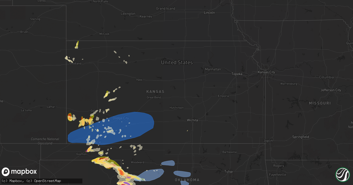
Hail Map in Kansas on June 15, 2023
Get this storm
June 15 map
$229
one time, instant access
Download today. No call, no setup
Keep the $229
Bought the map and want the full workflow? Apply the entire $229 to a subscription within 7 days. None of it is wasted.
Every map, not just this one
This buys you this map. Subscription and you get every map we run, in the markets you choose from a few cities to whole states to nationwide. Plus real-time alerts the moment a storm fires.
Contact data
Name, contact info, occupancy, even credit band for addresses in the footprint. You go from where it hit to who to call.
Become the source they trust
Unlimited branding weather history reports on demand. You already have the documented answer ready for the property owner, and you are the one who showed up with it.
Property data and RoofTrace estimates
Pull up any address you have got, its value and the exact code rules for that jurisdiction, straight from One Click Code. Then RoofTrace estimates the squares, pitch, and roof value, priced the way you price.
Storm reports in Kansas
Kansas
| Date | Description |
|---|---|
| 06/15/20235:50 PM CDT | Remarks from observer noted minor damage and tree limbs down due to high thunderstorm winds. |
| 06/15/20235:39 PM CDT | Asos station kddc dodge city regional airport. |
| 06/15/20235:32 PM CDT | A local report indicates 75 MPH wind near Fowler |
| 06/15/20235:30 PM CDT | The observer reported roof damage with peeled shingles from estimated 70 to 75 mph thunderstorm winds. |
| 06/15/20235:30 PM CDT | Large tree fell on to 3rd avenue damaging a couple of vehicles. |
| 06/15/20235:19 PM CDT | A local report indicates 69 MPH wind near Meade |
| 06/15/20234:58 PM CDT | A local report indicates 79 MPH wind near 1 NE Plains City |
| 06/15/20234:50 PM CDT | A local report indicates 58 MPH wind near 1 SW Hayne |
| 06/15/20234:45 PM CDT | A local report indicates 60 MPH wind near Kismet |
| 06/15/20234:35 PM CDT | Awos station k19s 1 ne sublette. |
| 06/15/20234:30 PM CDT | Sauk1 mesonet. |
| 06/15/20234:15 PM CDT | Reported at hugoton airport. |
| 06/15/20233:55 PM CDT | This was a 10-meter wind gust from kansas state mesonet station svuk1. |
| 06/15/20233:15 PM CDT | A local report indicates 1.75 inch wind near 5 NE Ulysses |
| 06/15/20232:40 PM CDT | A local report indicates 1.50 inch wind near Ulysses |
| 06/15/20232:35 PM CDT | A local report indicates 1.75 inch wind near 3 ENE Big Bow |
| 06/15/20232:16 PM CDT | A local report indicates 1.75 inch wind near 16 NNW Manter |
| 06/14/20237:16 PM CDT | Reported at medicine lodge airport. |
All States Impacted by Hail Map on June 15, 2023
Cities Impacted by Hail Map on June 15, 2023
- Bell, FL
- Branford, FL
- Old Town, FL
- High Springs, FL
- Trenton, FL
- Alachua, FL
- Newberry, FL
- Archer, FL
- Williston, FL
- Gainesville, FL
- Micanopy, FL
- Bronson, FL
- Chiefland, FL
- Lena, MS
- Forest, MS
- Rolling Fork, MS
- Mayersville, MS
- Valley Park, MS
- Decatur, MS
- Conehatta, MS
- Vienna, GA
- Cordele, GA
- Daleville, MS
- Lauderdale, MS
- Meridian, MS
- Newellton, LA
- Port Gibson, MS
- Cairo, GA
- Cuba, AL
- Ward, AL
- York, AL
- Jennings, FL
- Lee, FL
- Pattison, MS
- Statenville, GA
- Lake Park, GA
- Fargo, GA
- Sweet Water, AL
- Dixons Mills, AL
- Union Church, MS
- Hazlehurst, MS
- Thomasville, AL
- Magnolia, AL
- Pine Hill, AL
- Camden, AL
- Catherine, AL
- Arlington, AL
- Thomaston, AL
- Brookhaven, MS
- McCall Creek, MS
- Bogue Chitto, MS
- Summit, MS
- Grove Hill, AL
- Hasty, CO
- Las Animas, CO
- Mccomb, MS
- Ruth, MS
- Whatley, AL
- Franklin, AL
- Tylertown, MS
- Buena Vista, GA
- Eutaw, AL
- Clayton, AL
- Clio, AL
- Ariton, AL
- Greenville, AL
- Baskin, LA
- Mangham, LA
- Rayville, LA
- Fort Deposit, AL
- Honoraville, AL
- Douglas, GA
- West Green, GA
- Broxton, GA
- Whigham, GA
- Canton, MS
- Hurtsboro, AL
- Safford, AL
- Jachin, AL
- Pennington, AL
- Louisville, AL
- Midway, AL
- Sardis, AL
- Minter, AL
- Madison, FL
- Shorterville, AL
- Toomsuba, MS
- Cottondale, AL
- Brookwood, AL
- Tuscaloosa, AL
- Linden, AL
- Preston, GA
- Walnut Grove, MS
- Demopolis, AL
- Eufaula, AL
- Pittsview, AL
- Hatchechubbee, AL
- Troy, AL
- Jack, AL
- Perry, FL
- Bailey, MS
- De Kalb, MS
- Carthage, MS
- Georgetown, GA
- Cuthbert, GA
- Morris, GA
- Meadville, MS
- Lorman, MS
- Oak Ridge, LA
- Quitman, GA
- Pinetta, FL
- Uniontown, AL
- Marion Junction, AL
- Monroe, LA
- Bainbridge, GA
- Climax, GA
- Sondheimer, LA
- Lake Providence, LA
- Vicksburg, MS
- Tallulah, LA
- Camden, MS
- Coy, AL
- Cobb, GA
- Arabi, GA
- De Soto, GA
- Dawson, GA
- Shellman, GA
- Hayneville, AL
- Taft, TX
- Union, MS
- Sebastopol, MS
- Richland, GA
- Weston, GA
- Kosciusko, MS
- Yazoo City, MS
- Jasper, FL
- Peterman, AL
- Monroeville, AL
- Pelham, GA
- Ochlocknee, GA
- Plains, GA
- Americus, GA
- Parrott, GA
- Smithville, GA
- Collinsville, MS
- Lumpkin, GA
- Skipperville, AL
- Ozark, AL
- Newville, AL
- Abbeville, AL
- Clopton, AL
- Hermanville, MS
- Wesson, MS
- Faunsdale, AL
- Alberta, AL
- Winnsboro, LA
- Delhi, LA
- Saint Joseph, LA
- Gallion, AL
- Bastrop, LA
- Valdosta, GA
- Philadelphia, MS
- Nicholls, GA
- Benton, MS
- Leslie, GA
- Weogufka, AL
- Lower Peach Tree, AL
- Lisman, AL
- Marion, MS
- Evergreen, AL
- Holly, CO
- Granada, CO
- McKenzie, AL
- Manter, KS
- Johnson, KS
- Syracuse, KS
- Saint Francis, KS
- Bird City, KS
- Ulysses, KS
- Atmore, AL
- Brewton, AL
- Willow, OK
- Mangum, OK
- Granite, OK
- Franklinton, LA
- Folsom, LA
- Covington, LA
- Lone Wolf, OK
- Bush, LA
- Lakin, KS
- Satanta, KS
- Mountain Park, OK
- Roosevelt, OK
- Cleveland, GA
- Helen, GA
- Sautee Nacoochee, GA
- Salem, SC
- Sunset, SC
- Six Mile, SC
- Hemingford, NE
- Alliance, NE
- Stratton, NE
- Healy, KS
- Dighton, KS
- Trenton, NE
- Dansville, MI
- Mason, MI
- Webberville, MI
- Williamston, MI
- Stockbridge, MI
- Fowlerville, MI
- Howell, MI
- Gregory, MI
- Lawton, OK
- Mountain View, OK
- Hobart, OK
- Gotebo, OK
- Ooltewah, TN
- Harrison, TN
- Pinckney, MI
- McDonald, TN
- Brighton, MI
- Whitmore Lake, MI
- Hamburg, MI
- Dexter, MI
- Merriman, NE
- Ann Arbor, MI
- Elgin, OK
- Medicine Park, OK
- San Saba, TX
- Cherokee, TX
- South Lyon, MI
- Hooker, OK
- Jay, FL
- Central, SC
- Liberty, SC
- Pendleton, SC
- Fort Sill, OK
- Ypsilanti, MI
- Northville, MI
- Plymouth, MI
- Marlow, OK
- Fletcher, OK
- Pontotoc, TX
- Willis, MI
- Belleville, MI
- New Boston, MI
- Carleton, MI
- Milan, MI
- Milton, FL
- Baker, FL
- Bluffton, IN
- Markle, IN
- Uniondale, IN
- Ossian, IN
- Lawrenceburg, TN
- Geneva, IN
- Decatur, IN
- Berne, IN
- Leoma, TN
- Indiahoma, OK
- Monroe, IN
- Canton, MI
- Duncan, OK
- Walters, OK
- Cache, OK
- Valley Spring, TX
- Llano, TX
- Faxon, OK
- Geronimo, OK
- Newport, MI
- Monroe, MI
- Erie, MI
- Temperance, MI
- Toledo, OH
- Luna Pier, MI
- Beaver, OK
- Bryant, IN
- Balko, OK
- Spearman, TX
- Oregon, OH
- Perryton, TX
- Booker, TX
- Comanche, OK
- Rolla, KS
- Elkhart, KS
- Tyrone, OK
- Ensign, KS
- Hugoton, KS
- Plains, KS
- Richfield, KS
- Kismet, KS
- Ingalls, KS
- Cimarron, KS
- Copeland, KS
- Sublette, KS
- Liberal, KS
- Dodge City, KS
- Moscow, KS
- Montezuma, KS
- Forgan, OK
- Fowler, KS
- Meade, KS
- Turpin, OK
- Englewood, KS
- Minneola, KS
- Wright, KS
- Romulus, MI
- Spearville, KS
- Ford, KS
- Bucklin, KS
- Canadian, TX
- Harbor View, OH
- Vernon, TX
- Electra, TX
- Anderson, SC
- Curtice, OH
- Oak Harbor, OH
- Martin, OH
- Graytown, OH
- Port Clinton, OH
- Loco, OK
- Waurika, OK
- Ryan, OK
- Lacarne, OH
- Elmore, OH
- Rocky Ridge, OH
- Fremont, OH
- Vickery, OH
- Hardesty, OK
- Follett, TX
- Darrouzett, TX
- Lipscomb, TX
- Higgins, TX
- Laverne, OK
- Ashland, KS
- Protection, KS
- Coldwater, KS
- Mullinville, KS
- Greensburg, KS
- Haviland, KS
- Offerle, KS
- Kinsley, KS
- Temple, OK
- Clyde, OH
- Lakeside Marblehead, OH
- Castalia, OH
- Sandusky, OH
- Iowa Park, TX
- Arnett, OK
- Shattuck, OK
- Deerfield, MI
- Petersburg, MI
- Dundee, MI
- Yuma, CO
- Stratton, CO
- Olney Springs, CO
- Calhan, CO
- Ellsworth, NE
- Cody, NE
- Cottonwood, AL
- Stockton, AL
- Cedar City, UT
- Kanarraville, UT
- Palisade, NE
- Gordon, NE
- Goodland, KS
- Amite, LA
- Loranger, LA
- Kit Carson, CO
- Murfreesboro, TN
- Beryl, UT
- Delta, UT
- Hugo, CO
- Ramah, CO
- Holcomb, KS
- Garden City, KS
- Ponte Vedra, FL
- Saint Augustine, FL
- Ponte Vedra Beach, FL
- Saline, MI
- Valentine, NE
- Tamassee, SC
- Mountain Rest, SC
- Hampshire, TN
- Summertown, TN
- Kanorado, KS
- Lamar, CO
- Beeler, KS
- Seibert, CO
- Ringgold, GA
- Red Level, AL
- Monticello, FL
- Flomaton, AL
- Soddy Daisy, TN
- Iuka, MS
- Husser, LA
- Springfield, CO
- Franklin, TN
- Kilgore, NE
- Whitney, NE
- Chadron, NE
- Eagleville, TN
- Rockvale, TN
- Jackson, AL
- Daytona Beach, FL
- Pansey, AL
- Ashford, AL
- Ormond Beach, FL
- Coffeeville, AL
- Toxey, AL
- Silas, AL
- Gilbertown, AL
- Sopchoppy, FL
- Carrabelle, FL
- Panacea, FL
- Opp, AL
- Gantt, AL
- Dozier, AL
- Andalusia, AL
- Wing, AL
- Moore Haven, FL
- Dothan, AL
- Hixson, TN
- Prospect, TN
- Little River, AL
- Smithdale, MS
- Bay Minette, AL
- Agate, CO
- Chattanooga, TN
- Signal Mountain, TN
- Springfield, LA
- Ponchatoula, LA
- Livingston, LA
- Kirk, CO
- Kinston, AL
- New Smyrna Beach, FL
- Tyler, AL
- Letohatchee, AL
- College Grove, TN
- Thompsons Station, TN
- Magnolia, MS
- Laurel Hill, FL
- Florala, AL
- Huron, TN
- Slocomb, AL
- Hartford, AL
- Samson, AL
- Westville, FL
- Burlington, CO
- Blissfield, MI
- Rush, CO
- Lamont, FL
- Greenville, FL
- Apison, TN
- Tunnel Hill, GA
- Cohutta, GA
- Hill City, KS
- Trinidad, CO
- Crawford, NE
- Century, FL
- Uriah, AL
- Hohenwald, TN
- Williamston, SC
- Geneva, AL
- Cherokee, AL
- Tishomingo, MS
- Perdido, AL
- Ethridge, TN
- Vona, CO
- Okeechobee, FL
- Earleton, FL
- Hawthorne, FL
- Melrose, FL
- Vredenburgh, AL
- Holden, LA
- La Place, LA
- Saint Stephens, AL
- Gainestown, AL
- Range, AL
- Castleberry, AL
- Lenox, AL
- Frisco City, AL
- Repton, AL
- Norris, SC
- Beatrice, AL
- Gordon, AL
- Ringling, OK
- Healdton, OK
- Wilmore, KS
- Lewis, KS
- Buchanan Dam, TX
- Bellevue, OH
- Monroeville, OH
- Nocona, TX
- Wilson, OK
- Sun City, KS
- Coats, KS
- Pratt, KS
- Sawyer, KS
- Belpre, KS
- Macksville, KS
- Byers, KS
- Lone Grove, OK
- Wichita Falls, TX
- Gould, OK
- Duke, OK
- Reydon, OK
- Durham, OK
- Norwalk, OH
- Crawford, OK
- Willard, OH
- New London, OH
- Hollis, OK
- Collins, OH
- Hydro, OK
- Overbrook, OK
- Ardmore, OK
- Marietta, OK
- Hinton, OK
- Greenwich, OH
- North Fairfield, OH
- Altus, OK
- Olustee, OK
- Blair, OK
- Vero Beach, FL
- Nova, OH
- Geary, OK
- Cheyenne, OK
- Calumet, OK
- Hammon, OK
- Wakeman, OH
- Shiloh, OH
- Tow, TX
- Thackerville, OK
- Burneyville, OK
- Gainesville, TX
- Bluffton, TX
- El Reno, OK
- Burnet, TX
- Ashland, OH
- Sullivan, OH
- Bertram, TX
- Headrick, OK
- Butler, OK
- Polk, OH
- West Salem, OH
- Union City, OK
- Sayre, OK
- Yukon, OK
- Sweetwater, OK
- Erick, OK
- Binger, OK
- Minco, OK
- Whitesboro, TX
- Leedey, OK
- Taloga, OK
- Jeromesville, OH
- Niceville, FL
- Freeport, FL
- Elk City, OK
- Santa Rosa Beach, FL
- Clinton, OK
- Henrietta, TX
- Vici, OK
- Camargo, OK
- Seiling, OK
- Mutual, OK
- Chester, OK
- Fairview, OK
- Longdale, OK
- Isabella, OK
- Okeene, OK
- Putnam, OK
- Arapaho, OK
- Tuttle, OK
- Carter, OK
- Cleo Springs, OK
- Ringwood, OK
- Meno, OK
- Goltry, OK
- Lahoma, OK
- Helena, OK
- Wooster, OH
- Burbank, OH
- Carrier, OK
- Drummond, OK
- Enid, OK
- Oakwood, OK
- Canton, OK
- Southard, OK
- Watonga, OK
- Smithville, OH
- Chattanooga, OK
- Blanchard, OK
- Newcastle, OK
- Chelsea, MI
- Norman, OK
- Oklahoma City, OK
- Dalton, OH
- Apple Creek, OH
- Orrville, OH
- Millersburg, OH
- Fredericksburg, OH
- Dundee, OH
- Wilmot, OH
- Mount Eaton, OH
- Navarre, OH
- Beach City, OH
- Washington, OK
- Sugarcreek, OH
- Strasburg, OH
- Noble, OK
- Amber, OK
- Macomb, OK
- Lexington, OK
- Hennessey, OK
- Bison, OK
- Dover, OK
- Crescent, OK
- Guthrie, OK
- Mulhall, OK
- Orlando, OK
- Marshall, OK
- Cashion, OK
- Okarche, OK
- Kingfisher, OK
- Piedmont, OK
- Edmond, OK
- Pensacola, FL
- Howe, TX
- Sherman, TX
- Gunter, TX
- Van Alstyne, TX
- Jones, OK
- Arcadia, OK
- Gulf Breeze, FL
- Anna, TX
- New Philadelphia, OH
- Dover, OH
- Stone Creek, OH
- Gnadenhutten, OH
- Tuscarawas, OH
- Uhrichsville, OH
- Dennison, OH
- Midvale, OH
- Tippecanoe, OH
- Port Washington, OH
- Freeport, OH
- Cadiz, OH
- Blue Ridge, TX
- Farmersville, TX
- Celeste, TX
- Sanger, TX
- Valley View, TX
- Denton, TX
- Saint Jo, TX
- Muenster, TX
- Lindsay, TX
- Tioga, TX
- Collinsville, TX
- Pilot Point, TX
- Fostoria, OH
- Tiffin, OH
- New Riegel, OH
- Bascom, OH
- Leon, OK
- Sadler, TX
- Era, TX
- Quinlan, TX
- Wills Point, TX
- Thedford, NE
- Gregory, SD
- Onida, SD
- Dalton, NE
- Livonia, MI
- Winner, SD
- Roggen, CO
- Lodgepole, NE
- Wellington, OH
- Hawk Springs, WY
- Garden City, MI
- Gettysburg, SD
- Harrold, SD
- Bucyrus, OH
- Saint Francis, SD
- Mission, SD
- Nenzel, NE
- Lisco, NE
- Oshkosh, NE
- Penokee, KS
- Dewy Rose, GA
- Grover, CO
- Conway Springs, KS
- Wellington, KS
- Clearwater, KS
- Lindsay, OK
- Halsey, NE
- North Baltimore, OH
- Holt, FL
- Woodville, OH
- Gibsonburg, OH
- Lindsey, OH
- Cedar Key, FL
- Buffalo, OK
- Fort Pierce, FL
- Berlin Heights, OH
- Milan, OH
- Carnegie, OK
- Jennings, KS
- Fort Cobb, OK
- Gate, OK
- Hamill, SD
- Cantonment, FL
- Rosston, TX
- Rockledge, FL
- Gage, OK
- Hartwell, GA
- Iva, SC
- Starr, SC
- Terral, OK
- Ida, MI
- Limon, CO
- Lookeba, OK
- Republic, OH
- Bushnell, NE
- McDavid, FL
- Ferguson, NC
- Stratford, OK
- Belton, SC
- Plymouth, OH
- Green Springs, OH
- Lindon, CO
- Akron, CO
- Shelby, OH
- Arcadia, OH
- Findlay, OH
- Freedom, OK
- Weatherford, OK
- Lorida, FL
- Edson, KS
- Elwood, NE
- Brush, CO
- Hillrose, CO
- Flat Rock, MI
- Rockwood, MI
- South Rockwood, MI
- Lester, AL
- Elkmont, AL
- Minor Hill, TN
- Banks, AL
- Crestview, FL
- Merino, CO
- Detroit, MI
- Maybee, MI
- Melbourne, FL
- Gouldbusk, TX
- Bloomville, OH
- Ringgold, TX
- Lillian, AL
- Bells, TX
- Pottsboro, TX
- Whitewright, TX
- Gordonville, TX
- Tom Bean, TX
- Bloomdale, OH
- Alvada, OH
- Morland, KS
- Ness City, KS
- Utica, KS
- Arnold, KS
- Ransom, KS
- Briggsdale, CO
- Snyder, OK
- Hastings, OK
- Denison, TX
- Corn, OK
- Deland, FL
- Lake Helen, FL
- Huntington, IN
- Horseshoe Beach, FL
- Melbourne Beach, FL
- Clewiston, FL
- Weldona, CO
- Baltic, OH
- Spring Hill, TN
- McComb, OH
- Otis, CO
- Eglin Afb, FL
- Fort Recovery, OH
- Coldwater, OH
- Celina, OH
- Bogue, KS
- Kingsland, TX
- Valparaiso, FL
- Montague, TX
- Robertsdale, AL
- Georgiana, AL
- Aubrey, TX
- Celina, TX
- Mckinney, TX
- Prosper, TX
- Lone Oak, TX
- Wylie, TX
- Saltillo, TX
- Pecan Gap, TX
- Mount Vernon, TX
- Emory, TX
- Campbell, TX
- Mount Pleasant, TX
- Point, TX
- Winnsboro, TX
- Princeton, TX
- Forestburg, TX
- Randolph, TX
- Little Elm, TX
- Lavon, TX
- Klondike, TX
- Royse City, TX
- Como, TX
- Pickton, TX
- Edgewood, TX
- Terrell, TX
- Cumby, TX
- Talco, TX
- Nevada, TX
- Leonard, TX
- Trenton, TX
- Greenville, TX
- Caddo Mills, TX
- Wolfe City, TX
- Brashear, TX
- Cooper, TX
- Yantis, TX
- Rockwall, TX
- Savoy, TX
- Commerce, TX
- Dike, TX
- Frisco, TX
- Ector, TX
- Allen, TX
- Bailey, TX
- Sulphur Bluff, TX
- Plano, TX
- Alba, TX
- Ladonia, TX
- Bonham, TX
- Melissa, TX
- Sulphur Springs, TX
- Grand Saline, TX
- Winfield, TX
- Quitman, TX
- Fruitvale, TX
- Naples, TX
- Hughes Springs, TX
- Daingerfield, TX
- Pittsburg, TX
- Leesburg, TX
- Scroggins, TX
- Omaha, TX
- Cookville, TX
- Ben Wheeler, TX
- Gilmer, TX
- Canton, TX
- Tyler, TX
- Van, TX
- Arp, TX
- Mineola, TX
- Lindale, TX
- Gladewater, TX
- Hawkins, TX
- Big Sandy, TX
- Ore City, TX
- Winona, TX
- Lone Star, TX
- Marietta, TX
- Linden, TX
- Harleton, TX
- Hallsville, TX
- Jefferson, TX
- Longview, TX
- Kilgore, TX
- Bivins, TX
- Diana, TX
- Overton, TX
- White Oak, TX
- Avinger, TX
- Karnack, TX
- Beckville, TX
- Henderson, TX
- De Berry, TX
- Marshall, TX
- Tatum, TX
- Carthage, TX
- Waskom, TX
- Long Branch, TX
- Timpson, TX
- Mount Enterprise, TX
- Gary, TX
- Vivian, LA
- Tenaha, TX
- Mooringsport, LA
- Center, TX
- Joaquin, TX
- Shreveport, LA
- Logansport, LA
- Blanchard, LA
- Keatchie, LA
- Greenwood, LA
- Bethany, LA
- Oil City, LA
- Keithville, LA
- Belcher, LA
- Grand Cane, LA
- Mansfield, LA
- Stonewall, LA
- Gloster, LA
- Bossier City, LA
- Benton, LA
- Frierson, LA
- Princeton, LA
- Barksdale Afb, LA
- Haughton, LA
- Athens, TX
- Eustace, TX
- Malakoff, TX
- Fairfield, TX
- Pelican, LA
- Elm Grove, LA
- Converse, LA
- Doyline, LA
- Coushatta, LA
- Pleasant Hill, LA
- Heflin, LA
- Sibley, LA
- Ringgold, LA
- Noble, LA
- Belmont, LA
- Hemphill, TX
- Zwolle, LA
- Many, LA
- Hall Summit, LA
- Robeline, LA
- Marthaville, LA
- Provencal, LA
- Natchitoches, LA
- Jamestown, LA
- Goldonna, LA
- Gibsland, LA
- Dodson, LA
- Bienville, LA
- Jonesboro, LA
- Castor, LA
- Campti, LA
- Dubberly, LA
- Quitman, LA
- Saline, LA
- Ashland, LA
- Atlanta, LA
- Winnfield, LA
- Cloutierville, LA
- Lena, LA
- Melrose, LA
- Montgomery, LA
- Natchez, LA
- Colfax, LA
- Georgetown, LA
- Tullos, LA
- Olla, LA
- Dry Prong, LA
- Trout, LA
- Pollock, LA
- Bentley, LA
- Mansfield, OH
- Brownsboro, TX
- Chandler, TX
- Bellville, OH
- Fredericktown, OH
- Perrysville, OH
- Loudonville, OH
- Lucas, OH
- Summerdale, AL
- Seminole, AL
- Elberta, AL
- Baltimore, OH
- Crestline, OH
- Murchison, TX
- Bowerston, OH
- Newcomerstown, OH
- Leesville, OH
- Sherrodsville, OH
- Lake Creek, TX
- Edgewater, FL
- Honey Grove, TX
- Bowie, TX
- Eads, CO
- Scio, OH
- Paris, TX
- Shreve, OH
- Adena, OH
- Attica, OH
- Holmesville, OH
- Howard, OH
- Sebastian, FL
- Mount Vernon, OH
- Butler, OH
- Danville, OH
- Gambier, OH
- Custar, OH
- Cygnet, OH
- Graham, OK
- Jewett, OH
- Cheyenne Wells, CO
- Grant, FL
- Kendall, KS
- Pierceville, KS
- Roxton, TX
- Marion, LA
- Decatur, TX
- Bellevue, TX
- Madill, OK
- Larue, TX
- Frankston, TX
- Bullard, TX
- Flint, TX
- Jacksonville, TX
- Palestine, TX
- Rusk, TX
- Troup, TX
- Alto, TX
- Wells, TX
- Douglass, TX
- Nacogdoches, TX
- Pollok, TX
- Lufkin, TX
- Livingston, TX
- Chester, TX
- Diboll, TX
- Corrigan, TX
- Huntington, TX
- Utica, MS
- Raymond, MS
- Clinton, MS
- Flowood, MS
- Bolton, MS
- Byram, MS
- Braxton, MS
- Edwards, MS
- Mendenhall, MS
- Jackson, MS
- Ridgeland, MS
- Pearl, MS
- Terry, MS
- Madison, MS
- Richland, MS
- Brandon, MS
- Florence, MS
- Tougaloo, MS
- Flora, MS
- Bentonia, MS
- Satartia, MS
- Redwood, MS
- Epps, LA
- Gilbert, LA
- Crystal Springs, MS
- Harrisville, MS
- Taylorsville, MS
- Raleigh, MS
- Mize, MS
- Collins, MS
- Magee, MS
- Pelahatchie, MS
- Seminary, MS
- Mount Olive, MS
- Moselle, MS
- Ellisville, MS
- Soso, MS
- Paulding, MS
- Chunky, MS
- Vossburg, MS
- Heidelberg, MS
- Hickory, MS
- Pulaski, MS
- Newton, MS
- Rose Hill, MS
- Lawrence, MS
- Morton, MS
- Stringer, MS
- Louin, MS
- Bay Springs, MS
- Enterprise, MS
- Laurel, MS
- Lake, MS
- Pachuta, MS
- Little Rock, MS
- Ovett, MS
- Shubuta, MS
- Waynesboro, MS
- Richton, MS
- Stonewall, MS
- Quitman, MS
- Petal, MS
- Buckatunna, MS
- Sicily Island, LA
- Wisner, LA
- Fort Necessity, LA
- Columbia, LA
- Clayton, LA
- Waterproof, LA
- Georgetown, MS
- Calhoun, LA
- Columbia, MS
- Bassfield, MS
- Carson, MS
- Lusk, WY
- Foley, AL
- New Augusta, MS
- Beaumont, MS
- Brooklyn, MS
- West Monroe, LA
- New Brockton, AL
- Transylvania, LA
- Pioneer, LA
- Cary, MS
- Wiggins, MS
- Hattiesburg, MS
- Richland Springs, TX
- Windom, TX
- Perkinston, MS
- Eros, LA
- Quinton, OK
- Mcalester, OK
- Wilburton, OK
- Lucedale, MS
- Whitehouse, TX
- Silverhill, AL
- Mustang, OK
- Wilmer, AL
- Mayo, FL
- Fort Pierre, SD
- Farmerville, LA
- Millersport, OH
- Newhebron, MS
- Prentiss, MS
- Sumrall, MS
- Oak Vale, MS
- Silver Creek, MS
- Purvis, MS
- Kimbolton, OH
- Monticello, MS
- Sontag, MS
- Pinola, MS
- Pelzer, SC


