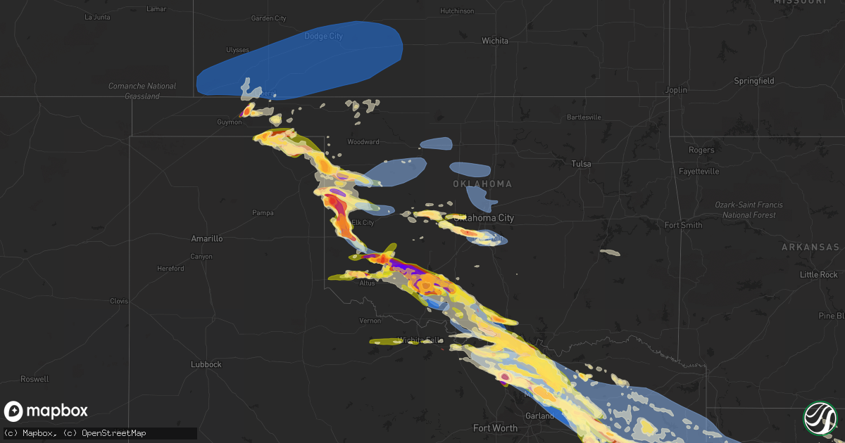
Hail Map in Oklahoma on June 15, 2023
Get this storm
June 15 map
$229
one time, instant access
Download today. No call, no setup
Keep the $229
Bought the map and want the full workflow? Apply the entire $229 to a subscription within 7 days. None of it is wasted.
Every map, not just this one
This buys you this map. Subscription and you get every map we run, in the markets you choose from a few cities to whole states to nationwide. Plus real-time alerts the moment a storm fires.
Contact data
Name, contact info, occupancy, even credit band for addresses in the footprint. You go from where it hit to who to call.
Become the source they trust
Unlimited branding weather history reports on demand. You already have the documented answer ready for the property owner, and you are the one who showed up with it.
Property data and RoofTrace estimates
Pull up any address you have got, its value and the exact code rules for that jurisdiction, straight from One Click Code. Then RoofTrace estimates the squares, pitch, and roof value, priced the way you price.
Storm reports in Oklahoma
Oklahoma
| Date | Description |
|---|---|
| 06/15/20236:52 PM CDT | Report from mping: quarter |
| 06/15/20236:47 PM CDT | A local report indicates a tornado near 7 SSW Durham |
| 06/15/20236:37 PM CDT | Twitter video. |
| 06/15/20236:35 PM CDT | Report from mping: half dollar |
| 06/15/20236:31 PM CDT | Tornado likely entered ellis county as it was dissipating. |
| 06/15/20236:26 PM CDT | Storm chaser image. |
| 06/15/20236:20 PM CDT | Tree damage... Large tree snapped... And roof damage/shingles ripped out. Time was estimated. |
| 06/15/20236:05 PM CDT | A local report indicates 61 MPH wind near 1 E Waurika |
| 06/15/20235:44 PM CDT | Report from mping: quarter |
| 06/15/20235:36 PM CDT | Ping pong to golf ball hail. Person was blown off the road 3 time. |
| 06/15/20235:29 PM CDT | Report from mping: quarter |
| 06/15/20235:26 PM CDT | Power poles snapped. |
| 06/15/20235:20 PM CDT | A local report indicates 80 MPH wind near Walters |
| 06/15/20235:20 PM CDT | A local report indicates 58 MPH wind near 8 W Slapout |
| 06/15/20235:19 PM CDT | Roof off of house per storm chaser. |
| 06/15/20235:11 PM CDT | Light roof damage to an outbuilding and manufactured home. Time estimated via radar. |
| 06/15/20235:01 PM CDT | A local report indicates 1.00 inch wind near 1 N Duncan |
| 06/15/20235:01 PM CDT | Via spotternetwork.org-measured 1.85 hail stone at this location. |
| 06/15/20235:00 PM CDT | Report from mping: golf ball |
| 06/15/20235:00 PM CDT | Twitter image. |
| 06/15/20234:59 PM CDT | Report from mping: baseball |
| 06/15/20234:57 PM CDT | A local report indicates 1.75 inch wind near 2 S Cache |
| 06/15/20234:57 PM CDT | Report from mping: golf ball |
| 06/15/20234:55 PM CDT | Large trees uprooted and light roof damage to a residence. Time estimated via radar. |
| 06/15/20234:52 PM CDT | Report from mping: hen egg |
| 06/15/20234:46 PM CDT | A local report indicates 1.75 inch wind near 4 WSW Central High |
| 06/15/20234:45 PM CDT | Report from mping: tea cup |
| 06/15/20234:40 PM CDT | A local report indicates 2.00 inch wind near 3 WSW Lawton |
| 06/15/20234:40 PM CDT | Tree damage reported in lawton. |
| 06/15/20234:38 PM CDT | Report from mping: ping pong ball |
| 06/15/20234:34 PM CDT | A local report indicates 2.75 inch wind near 4 N Fort Sill |
| 06/15/20234:34 PM CDT | A local report indicates 2.75 inch wind near 4 N Fort Sill |
| 06/15/20234:33 PM CDT | A local report indicates 2.50 inch wind near Fort Sill |
| 06/15/20234:26 PM CDT | Ongoing at time of report. |
| 06/15/20234:12 PM CDT | Report from mping: half dollar |
| 06/15/20234:03 PM CDT | Spotter network report. |
| 06/15/20233:57 PM CDT | Public sent in an image. |
| 06/15/20233:57 PM CDT | Estimated between 2 to 2.5 in hail. |
| 06/15/20233:37 PM CDT | Report from mping: baseball |
| 06/15/20233:33 PM CDT | A local report indicates 1.90 inch wind near Lone Wolf |
| 06/15/20233:12 PM CDT | A local report indicates 1.34 inch wind near Granite |
| 06/15/20233:12 PM CDT | A local report indicates 1.75 inch wind near Granite |
| 06/15/20233:10 PM CDT | A local report indicates 1.25 inch wind near 5 W Lone Wolf |
| 06/15/20233:05 PM CDT | Report from mping: quarter |
| 06/15/20233:05 PM CDT | Report from mping: quarter . |
| 06/15/20232:48 PM CDT | Report from mping: half dollar |
| 06/15/202312:34 AM CDT | Report from mping: quarter |
| 06/15/202312:23 AM CDT | Report from mping: half dollar |
| 06/15/202312:18 AM CDT | A local report indicates 1.75 inch wind near 3 S Lone Grove |
| 06/15/202312:14 AM CDT | A local report indicates 2.00 inch wind near Lone Grove |
| 06/15/202312:14 AM CDT | Report from mping: golf ball |
| 06/15/202312:12 AM CDT | Report from mping: quarter |
| 06/15/202312:08 AM CDT | Report from mping: half dollar |
| 06/14/202311:30 PM CDT | Large tree uprooted... Several trees snapped... And damage to an aluminum building. |
| 06/14/202311:04 PM CDT | Report from mping: quarter |
| 06/14/202310:48 PM CDT | Two trees down partially in the fast lane of i-35 at mile marker 6. |
| 06/14/202310:48 PM CDT | Multiple trees down. Radar estimated time. |
| 06/14/202310:47 PM CDT | Two semis rolled over on i-35 at mile marker 11. Radar estimated time. |
| 06/14/202310:45 PM CDT | Tree on a house in shady dale area along with multiple power poles down. Radar estimated time. |
| 06/14/202310:40 PM CDT | A local report indicates 61 MPH wind near 6 SW Fittstown |
| 06/14/202310:30 PM CDT | Corum fire dept building damaged. |
| 06/14/202310:30 PM CDT | Tree downed into the main feeder line for hominy knocking power out to the community for 45 minutes. |
| 06/14/202310:20 PM CDT | Aluminum roof of church partially ripped off. |
| 06/14/202310:05 PM CDT | Significant roof damage to a building at konawa high school. Time was estimated via radar. |
| 06/14/20239:20 PM CDT | A local report indicates 84 MPH wind near 2 NNW Norman |
| 06/14/20239:20 PM CDT | A local report indicates 1.50 inch wind near Hobart |
| 06/14/20239:20 PM CDT | A local report indicates 1.00 inch wind near 3 NE Goldsby |
| 06/14/20239:12 PM CDT | Hwy 9 and penn. |
| 06/14/20239:03 PM CDT | Report from mping: quarter |
| 06/14/20239:00 PM CDT | A local report indicates 67 MPH wind near 4 SSE Marshall |
| 06/14/20238:55 PM CDT | A local report indicates 64 MPH wind near 4 SE Hobart |
| 06/14/20238:53 PM CDT | A local report indicates 1.75 inch wind near 1 WSW Newcastle |
| 06/14/20238:50 PM CDT | Time estimated by radar. |
| 06/14/20238:49 PM CDT | A local report indicates 2.00 inch wind near Bridge Creek |
| 06/14/20238:49 PM CDT | Hwy 4 and fox ln. |
| 06/14/20238:30 PM CDT | A local report indicates 1.00 inch wind near Tuttle |
| 06/14/20238:28 PM CDT | A local report indicates 1.75 inch wind near Tuttle |
| 06/14/20238:25 PM CDT | A local report indicates 60 MPH wind near 1 W Lahoma |
| 06/14/20238:11 PM CDT | A local report indicates 68 MPH wind near Ringwood |
| 06/14/20238:10 PM CDT | Semi-trailer flipped. |
| 06/14/20238:07 PM CDT | Report from mping: quarter |
| 06/14/20238:05 PM CDT | A local report indicates 58 MPH wind near 2 N Putnam |
| 06/14/20238:05 PM CDT | A local report indicates 2.00 inch wind near Sayre |
| 06/14/20237:55 PM CDT | A local report indicates 63 MPH wind near 5 SW Butler |
| 06/14/20237:50 PM CDT | Some trees damaged in the town of fairview. |
| 06/14/20237:46 PM CDT | Report from mping: hen egg |
| 06/14/20237:44 PM CDT | Report from mping: half dollar |
| 06/14/20237:37 PM CDT | Report from mping: quarter |
| 06/14/20237:31 PM CDT | A local report indicates 2.00 inch wind near 3 E Martha |
| 06/14/20237:31 PM CDT | Report from mping: quarter |
| 06/14/20237:30 PM CDT | A local report indicates 1.50 inch wind near 2 N Hinton |
| 06/14/20237:30 PM CDT | A local report indicates 65 MPH wind near 4 NW Seiling |
| 06/14/20237:26 PM CDT | Powerlines down in marietta. |
| 06/14/20237:20 PM CDT | Report from mping: trees uprooted or snapped; roof blown off. |
| 06/14/20237:17 PM CDT | A local report indicates 2.25 inch wind near 4 N Reydon |
| 06/14/20237:17 PM CDT | A local report indicates 2.75 inch wind near 1 NW Reydon |
| 06/14/20237:15 PM CDT | Several trees snapped... Roof damage on home with shingles ripped up. |
| 06/14/20237:13 PM CDT | Several trees down in the town of burneyville. Time estimated by radar. |
| 06/14/20237:12 PM CDT | A local report indicates 59 MPH wind near 1 NE Woodward |
| 06/14/20237:04 PM CDT | Report from mping: 3-inch tree limbs broken; power poles broken. |
All States Impacted by Hail Map on June 15, 2023
Cities Impacted by Hail Map on June 15, 2023
- Bell, FL
- Branford, FL
- Old Town, FL
- High Springs, FL
- Trenton, FL
- Alachua, FL
- Newberry, FL
- Archer, FL
- Williston, FL
- Gainesville, FL
- Micanopy, FL
- Bronson, FL
- Chiefland, FL
- Lena, MS
- Forest, MS
- Rolling Fork, MS
- Mayersville, MS
- Valley Park, MS
- Decatur, MS
- Conehatta, MS
- Vienna, GA
- Cordele, GA
- Daleville, MS
- Lauderdale, MS
- Meridian, MS
- Newellton, LA
- Port Gibson, MS
- Cairo, GA
- Cuba, AL
- Ward, AL
- York, AL
- Jennings, FL
- Lee, FL
- Pattison, MS
- Statenville, GA
- Lake Park, GA
- Fargo, GA
- Sweet Water, AL
- Dixons Mills, AL
- Union Church, MS
- Hazlehurst, MS
- Thomasville, AL
- Magnolia, AL
- Pine Hill, AL
- Camden, AL
- Catherine, AL
- Arlington, AL
- Thomaston, AL
- Brookhaven, MS
- McCall Creek, MS
- Bogue Chitto, MS
- Summit, MS
- Grove Hill, AL
- Hasty, CO
- Las Animas, CO
- Mccomb, MS
- Ruth, MS
- Whatley, AL
- Franklin, AL
- Tylertown, MS
- Buena Vista, GA
- Eutaw, AL
- Clayton, AL
- Clio, AL
- Ariton, AL
- Greenville, AL
- Baskin, LA
- Mangham, LA
- Rayville, LA
- Fort Deposit, AL
- Honoraville, AL
- Douglas, GA
- West Green, GA
- Broxton, GA
- Whigham, GA
- Canton, MS
- Hurtsboro, AL
- Safford, AL
- Jachin, AL
- Pennington, AL
- Louisville, AL
- Midway, AL
- Sardis, AL
- Minter, AL
- Madison, FL
- Shorterville, AL
- Toomsuba, MS
- Cottondale, AL
- Brookwood, AL
- Tuscaloosa, AL
- Linden, AL
- Preston, GA
- Walnut Grove, MS
- Demopolis, AL
- Eufaula, AL
- Pittsview, AL
- Hatchechubbee, AL
- Troy, AL
- Jack, AL
- Perry, FL
- Bailey, MS
- De Kalb, MS
- Carthage, MS
- Georgetown, GA
- Cuthbert, GA
- Morris, GA
- Meadville, MS
- Lorman, MS
- Oak Ridge, LA
- Quitman, GA
- Pinetta, FL
- Uniontown, AL
- Marion Junction, AL
- Monroe, LA
- Bainbridge, GA
- Climax, GA
- Sondheimer, LA
- Lake Providence, LA
- Vicksburg, MS
- Tallulah, LA
- Camden, MS
- Coy, AL
- Cobb, GA
- Arabi, GA
- De Soto, GA
- Dawson, GA
- Shellman, GA
- Hayneville, AL
- Taft, TX
- Union, MS
- Sebastopol, MS
- Richland, GA
- Weston, GA
- Kosciusko, MS
- Yazoo City, MS
- Jasper, FL
- Peterman, AL
- Monroeville, AL
- Pelham, GA
- Ochlocknee, GA
- Plains, GA
- Americus, GA
- Parrott, GA
- Smithville, GA
- Collinsville, MS
- Lumpkin, GA
- Skipperville, AL
- Ozark, AL
- Newville, AL
- Abbeville, AL
- Clopton, AL
- Hermanville, MS
- Wesson, MS
- Faunsdale, AL
- Alberta, AL
- Winnsboro, LA
- Delhi, LA
- Saint Joseph, LA
- Gallion, AL
- Bastrop, LA
- Valdosta, GA
- Philadelphia, MS
- Nicholls, GA
- Benton, MS
- Leslie, GA
- Weogufka, AL
- Lower Peach Tree, AL
- Lisman, AL
- Marion, MS
- Evergreen, AL
- Holly, CO
- Granada, CO
- McKenzie, AL
- Manter, KS
- Johnson, KS
- Syracuse, KS
- Saint Francis, KS
- Bird City, KS
- Ulysses, KS
- Atmore, AL
- Brewton, AL
- Willow, OK
- Mangum, OK
- Granite, OK
- Franklinton, LA
- Folsom, LA
- Covington, LA
- Lone Wolf, OK
- Bush, LA
- Lakin, KS
- Satanta, KS
- Mountain Park, OK
- Roosevelt, OK
- Cleveland, GA
- Helen, GA
- Sautee Nacoochee, GA
- Salem, SC
- Sunset, SC
- Six Mile, SC
- Hemingford, NE
- Alliance, NE
- Stratton, NE
- Healy, KS
- Dighton, KS
- Trenton, NE
- Dansville, MI
- Mason, MI
- Webberville, MI
- Williamston, MI
- Stockbridge, MI
- Fowlerville, MI
- Howell, MI
- Gregory, MI
- Lawton, OK
- Mountain View, OK
- Hobart, OK
- Gotebo, OK
- Ooltewah, TN
- Harrison, TN
- Pinckney, MI
- McDonald, TN
- Brighton, MI
- Whitmore Lake, MI
- Hamburg, MI
- Dexter, MI
- Merriman, NE
- Ann Arbor, MI
- Elgin, OK
- Medicine Park, OK
- San Saba, TX
- Cherokee, TX
- South Lyon, MI
- Hooker, OK
- Jay, FL
- Central, SC
- Liberty, SC
- Pendleton, SC
- Fort Sill, OK
- Ypsilanti, MI
- Northville, MI
- Plymouth, MI
- Marlow, OK
- Fletcher, OK
- Pontotoc, TX
- Willis, MI
- Belleville, MI
- New Boston, MI
- Carleton, MI
- Milan, MI
- Milton, FL
- Baker, FL
- Bluffton, IN
- Markle, IN
- Uniondale, IN
- Ossian, IN
- Lawrenceburg, TN
- Geneva, IN
- Decatur, IN
- Berne, IN
- Leoma, TN
- Indiahoma, OK
- Monroe, IN
- Canton, MI
- Duncan, OK
- Walters, OK
- Cache, OK
- Valley Spring, TX
- Llano, TX
- Faxon, OK
- Geronimo, OK
- Newport, MI
- Monroe, MI
- Erie, MI
- Temperance, MI
- Toledo, OH
- Luna Pier, MI
- Beaver, OK
- Bryant, IN
- Balko, OK
- Spearman, TX
- Oregon, OH
- Perryton, TX
- Booker, TX
- Comanche, OK
- Rolla, KS
- Elkhart, KS
- Tyrone, OK
- Ensign, KS
- Hugoton, KS
- Plains, KS
- Richfield, KS
- Kismet, KS
- Ingalls, KS
- Cimarron, KS
- Copeland, KS
- Sublette, KS
- Liberal, KS
- Dodge City, KS
- Moscow, KS
- Montezuma, KS
- Forgan, OK
- Fowler, KS
- Meade, KS
- Turpin, OK
- Englewood, KS
- Minneola, KS
- Wright, KS
- Romulus, MI
- Spearville, KS
- Ford, KS
- Bucklin, KS
- Canadian, TX
- Harbor View, OH
- Vernon, TX
- Electra, TX
- Anderson, SC
- Curtice, OH
- Oak Harbor, OH
- Martin, OH
- Graytown, OH
- Port Clinton, OH
- Loco, OK
- Waurika, OK
- Ryan, OK
- Lacarne, OH
- Elmore, OH
- Rocky Ridge, OH
- Fremont, OH
- Vickery, OH
- Hardesty, OK
- Follett, TX
- Darrouzett, TX
- Lipscomb, TX
- Higgins, TX
- Laverne, OK
- Ashland, KS
- Protection, KS
- Coldwater, KS
- Mullinville, KS
- Greensburg, KS
- Haviland, KS
- Offerle, KS
- Kinsley, KS
- Temple, OK
- Clyde, OH
- Lakeside Marblehead, OH
- Castalia, OH
- Sandusky, OH
- Iowa Park, TX
- Arnett, OK
- Shattuck, OK
- Deerfield, MI
- Petersburg, MI
- Dundee, MI
- Yuma, CO
- Stratton, CO
- Olney Springs, CO
- Calhan, CO
- Ellsworth, NE
- Cody, NE
- Cottonwood, AL
- Stockton, AL
- Cedar City, UT
- Kanarraville, UT
- Palisade, NE
- Gordon, NE
- Goodland, KS
- Amite, LA
- Loranger, LA
- Kit Carson, CO
- Murfreesboro, TN
- Beryl, UT
- Delta, UT
- Hugo, CO
- Ramah, CO
- Holcomb, KS
- Garden City, KS
- Ponte Vedra, FL
- Saint Augustine, FL
- Ponte Vedra Beach, FL
- Saline, MI
- Valentine, NE
- Tamassee, SC
- Mountain Rest, SC
- Hampshire, TN
- Summertown, TN
- Kanorado, KS
- Lamar, CO
- Beeler, KS
- Seibert, CO
- Ringgold, GA
- Red Level, AL
- Monticello, FL
- Flomaton, AL
- Soddy Daisy, TN
- Iuka, MS
- Husser, LA
- Springfield, CO
- Franklin, TN
- Kilgore, NE
- Whitney, NE
- Chadron, NE
- Eagleville, TN
- Rockvale, TN
- Jackson, AL
- Daytona Beach, FL
- Pansey, AL
- Ashford, AL
- Ormond Beach, FL
- Coffeeville, AL
- Toxey, AL
- Silas, AL
- Gilbertown, AL
- Sopchoppy, FL
- Carrabelle, FL
- Panacea, FL
- Opp, AL
- Gantt, AL
- Dozier, AL
- Andalusia, AL
- Wing, AL
- Moore Haven, FL
- Dothan, AL
- Hixson, TN
- Prospect, TN
- Little River, AL
- Smithdale, MS
- Bay Minette, AL
- Agate, CO
- Chattanooga, TN
- Signal Mountain, TN
- Springfield, LA
- Ponchatoula, LA
- Livingston, LA
- Kirk, CO
- Kinston, AL
- New Smyrna Beach, FL
- Tyler, AL
- Letohatchee, AL
- College Grove, TN
- Thompsons Station, TN
- Magnolia, MS
- Laurel Hill, FL
- Florala, AL
- Huron, TN
- Slocomb, AL
- Hartford, AL
- Samson, AL
- Westville, FL
- Burlington, CO
- Blissfield, MI
- Rush, CO
- Lamont, FL
- Greenville, FL
- Apison, TN
- Tunnel Hill, GA
- Cohutta, GA
- Hill City, KS
- Trinidad, CO
- Crawford, NE
- Century, FL
- Uriah, AL
- Hohenwald, TN
- Williamston, SC
- Geneva, AL
- Cherokee, AL
- Tishomingo, MS
- Perdido, AL
- Ethridge, TN
- Vona, CO
- Okeechobee, FL
- Earleton, FL
- Hawthorne, FL
- Melrose, FL
- Vredenburgh, AL
- Holden, LA
- La Place, LA
- Saint Stephens, AL
- Gainestown, AL
- Range, AL
- Castleberry, AL
- Lenox, AL
- Frisco City, AL
- Repton, AL
- Norris, SC
- Beatrice, AL
- Gordon, AL
- Ringling, OK
- Healdton, OK
- Wilmore, KS
- Lewis, KS
- Buchanan Dam, TX
- Bellevue, OH
- Monroeville, OH
- Nocona, TX
- Wilson, OK
- Sun City, KS
- Coats, KS
- Pratt, KS
- Sawyer, KS
- Belpre, KS
- Macksville, KS
- Byers, KS
- Lone Grove, OK
- Wichita Falls, TX
- Gould, OK
- Duke, OK
- Reydon, OK
- Durham, OK
- Norwalk, OH
- Crawford, OK
- Willard, OH
- New London, OH
- Hollis, OK
- Collins, OH
- Hydro, OK
- Overbrook, OK
- Ardmore, OK
- Marietta, OK
- Hinton, OK
- Greenwich, OH
- North Fairfield, OH
- Altus, OK
- Olustee, OK
- Blair, OK
- Vero Beach, FL
- Nova, OH
- Geary, OK
- Cheyenne, OK
- Calumet, OK
- Hammon, OK
- Wakeman, OH
- Shiloh, OH
- Tow, TX
- Thackerville, OK
- Burneyville, OK
- Gainesville, TX
- Bluffton, TX
- El Reno, OK
- Burnet, TX
- Ashland, OH
- Sullivan, OH
- Bertram, TX
- Headrick, OK
- Butler, OK
- Polk, OH
- West Salem, OH
- Union City, OK
- Sayre, OK
- Yukon, OK
- Sweetwater, OK
- Erick, OK
- Binger, OK
- Minco, OK
- Whitesboro, TX
- Leedey, OK
- Taloga, OK
- Jeromesville, OH
- Niceville, FL
- Freeport, FL
- Elk City, OK
- Santa Rosa Beach, FL
- Clinton, OK
- Henrietta, TX
- Vici, OK
- Camargo, OK
- Seiling, OK
- Mutual, OK
- Chester, OK
- Fairview, OK
- Longdale, OK
- Isabella, OK
- Okeene, OK
- Putnam, OK
- Arapaho, OK
- Tuttle, OK
- Carter, OK
- Cleo Springs, OK
- Ringwood, OK
- Meno, OK
- Goltry, OK
- Lahoma, OK
- Helena, OK
- Wooster, OH
- Burbank, OH
- Carrier, OK
- Drummond, OK
- Enid, OK
- Oakwood, OK
- Canton, OK
- Southard, OK
- Watonga, OK
- Smithville, OH
- Chattanooga, OK
- Blanchard, OK
- Newcastle, OK
- Chelsea, MI
- Norman, OK
- Oklahoma City, OK
- Dalton, OH
- Apple Creek, OH
- Orrville, OH
- Millersburg, OH
- Fredericksburg, OH
- Dundee, OH
- Wilmot, OH
- Mount Eaton, OH
- Navarre, OH
- Beach City, OH
- Washington, OK
- Sugarcreek, OH
- Strasburg, OH
- Noble, OK
- Amber, OK
- Macomb, OK
- Lexington, OK
- Hennessey, OK
- Bison, OK
- Dover, OK
- Crescent, OK
- Guthrie, OK
- Mulhall, OK
- Orlando, OK
- Marshall, OK
- Cashion, OK
- Okarche, OK
- Kingfisher, OK
- Piedmont, OK
- Edmond, OK
- Pensacola, FL
- Howe, TX
- Sherman, TX
- Gunter, TX
- Van Alstyne, TX
- Jones, OK
- Arcadia, OK
- Gulf Breeze, FL
- Anna, TX
- New Philadelphia, OH
- Dover, OH
- Stone Creek, OH
- Gnadenhutten, OH
- Tuscarawas, OH
- Uhrichsville, OH
- Dennison, OH
- Midvale, OH
- Tippecanoe, OH
- Port Washington, OH
- Freeport, OH
- Cadiz, OH
- Blue Ridge, TX
- Farmersville, TX
- Celeste, TX
- Sanger, TX
- Valley View, TX
- Denton, TX
- Saint Jo, TX
- Muenster, TX
- Lindsay, TX
- Tioga, TX
- Collinsville, TX
- Pilot Point, TX
- Fostoria, OH
- Tiffin, OH
- New Riegel, OH
- Bascom, OH
- Leon, OK
- Sadler, TX
- Era, TX
- Quinlan, TX
- Wills Point, TX
- Thedford, NE
- Gregory, SD
- Onida, SD
- Dalton, NE
- Livonia, MI
- Winner, SD
- Roggen, CO
- Lodgepole, NE
- Wellington, OH
- Hawk Springs, WY
- Garden City, MI
- Gettysburg, SD
- Harrold, SD
- Bucyrus, OH
- Saint Francis, SD
- Mission, SD
- Nenzel, NE
- Lisco, NE
- Oshkosh, NE
- Penokee, KS
- Dewy Rose, GA
- Grover, CO
- Conway Springs, KS
- Wellington, KS
- Clearwater, KS
- Lindsay, OK
- Halsey, NE
- North Baltimore, OH
- Holt, FL
- Woodville, OH
- Gibsonburg, OH
- Lindsey, OH
- Cedar Key, FL
- Buffalo, OK
- Fort Pierce, FL
- Berlin Heights, OH
- Milan, OH
- Carnegie, OK
- Jennings, KS
- Fort Cobb, OK
- Gate, OK
- Hamill, SD
- Cantonment, FL
- Rosston, TX
- Rockledge, FL
- Gage, OK
- Hartwell, GA
- Iva, SC
- Starr, SC
- Terral, OK
- Ida, MI
- Limon, CO
- Lookeba, OK
- Republic, OH
- Bushnell, NE
- McDavid, FL
- Ferguson, NC
- Stratford, OK
- Belton, SC
- Plymouth, OH
- Green Springs, OH
- Lindon, CO
- Akron, CO
- Shelby, OH
- Arcadia, OH
- Findlay, OH
- Freedom, OK
- Weatherford, OK
- Lorida, FL
- Edson, KS
- Elwood, NE
- Brush, CO
- Hillrose, CO
- Flat Rock, MI
- Rockwood, MI
- South Rockwood, MI
- Lester, AL
- Elkmont, AL
- Minor Hill, TN
- Banks, AL
- Crestview, FL
- Merino, CO
- Detroit, MI
- Maybee, MI
- Melbourne, FL
- Gouldbusk, TX
- Bloomville, OH
- Ringgold, TX
- Lillian, AL
- Bells, TX
- Pottsboro, TX
- Whitewright, TX
- Gordonville, TX
- Tom Bean, TX
- Bloomdale, OH
- Alvada, OH
- Morland, KS
- Ness City, KS
- Utica, KS
- Arnold, KS
- Ransom, KS
- Briggsdale, CO
- Snyder, OK
- Hastings, OK
- Denison, TX
- Corn, OK
- Deland, FL
- Lake Helen, FL
- Huntington, IN
- Horseshoe Beach, FL
- Melbourne Beach, FL
- Clewiston, FL
- Weldona, CO
- Baltic, OH
- Spring Hill, TN
- McComb, OH
- Otis, CO
- Eglin Afb, FL
- Fort Recovery, OH
- Coldwater, OH
- Celina, OH
- Bogue, KS
- Kingsland, TX
- Valparaiso, FL
- Montague, TX
- Robertsdale, AL
- Georgiana, AL
- Aubrey, TX
- Celina, TX
- Mckinney, TX
- Prosper, TX
- Lone Oak, TX
- Wylie, TX
- Saltillo, TX
- Pecan Gap, TX
- Mount Vernon, TX
- Emory, TX
- Campbell, TX
- Mount Pleasant, TX
- Point, TX
- Winnsboro, TX
- Princeton, TX
- Forestburg, TX
- Randolph, TX
- Little Elm, TX
- Lavon, TX
- Klondike, TX
- Royse City, TX
- Como, TX
- Pickton, TX
- Edgewood, TX
- Terrell, TX
- Cumby, TX
- Talco, TX
- Nevada, TX
- Leonard, TX
- Trenton, TX
- Greenville, TX
- Caddo Mills, TX
- Wolfe City, TX
- Brashear, TX
- Cooper, TX
- Yantis, TX
- Rockwall, TX
- Savoy, TX
- Commerce, TX
- Dike, TX
- Frisco, TX
- Ector, TX
- Allen, TX
- Bailey, TX
- Sulphur Bluff, TX
- Plano, TX
- Alba, TX
- Ladonia, TX
- Bonham, TX
- Melissa, TX
- Sulphur Springs, TX
- Grand Saline, TX
- Winfield, TX
- Quitman, TX
- Fruitvale, TX
- Naples, TX
- Hughes Springs, TX
- Daingerfield, TX
- Pittsburg, TX
- Leesburg, TX
- Scroggins, TX
- Omaha, TX
- Cookville, TX
- Ben Wheeler, TX
- Gilmer, TX
- Canton, TX
- Tyler, TX
- Van, TX
- Arp, TX
- Mineola, TX
- Lindale, TX
- Gladewater, TX
- Hawkins, TX
- Big Sandy, TX
- Ore City, TX
- Winona, TX
- Lone Star, TX
- Marietta, TX
- Linden, TX
- Harleton, TX
- Hallsville, TX
- Jefferson, TX
- Longview, TX
- Kilgore, TX
- Bivins, TX
- Diana, TX
- Overton, TX
- White Oak, TX
- Avinger, TX
- Karnack, TX
- Beckville, TX
- Henderson, TX
- De Berry, TX
- Marshall, TX
- Tatum, TX
- Carthage, TX
- Waskom, TX
- Long Branch, TX
- Timpson, TX
- Mount Enterprise, TX
- Gary, TX
- Vivian, LA
- Tenaha, TX
- Mooringsport, LA
- Center, TX
- Joaquin, TX
- Shreveport, LA
- Logansport, LA
- Blanchard, LA
- Keatchie, LA
- Greenwood, LA
- Bethany, LA
- Oil City, LA
- Keithville, LA
- Belcher, LA
- Grand Cane, LA
- Mansfield, LA
- Stonewall, LA
- Gloster, LA
- Bossier City, LA
- Benton, LA
- Frierson, LA
- Princeton, LA
- Barksdale Afb, LA
- Haughton, LA
- Athens, TX
- Eustace, TX
- Malakoff, TX
- Fairfield, TX
- Pelican, LA
- Elm Grove, LA
- Converse, LA
- Doyline, LA
- Coushatta, LA
- Pleasant Hill, LA
- Heflin, LA
- Sibley, LA
- Ringgold, LA
- Noble, LA
- Belmont, LA
- Hemphill, TX
- Zwolle, LA
- Many, LA
- Hall Summit, LA
- Robeline, LA
- Marthaville, LA
- Provencal, LA
- Natchitoches, LA
- Jamestown, LA
- Goldonna, LA
- Gibsland, LA
- Dodson, LA
- Bienville, LA
- Jonesboro, LA
- Castor, LA
- Campti, LA
- Dubberly, LA
- Quitman, LA
- Saline, LA
- Ashland, LA
- Atlanta, LA
- Winnfield, LA
- Cloutierville, LA
- Lena, LA
- Melrose, LA
- Montgomery, LA
- Natchez, LA
- Colfax, LA
- Georgetown, LA
- Tullos, LA
- Olla, LA
- Dry Prong, LA
- Trout, LA
- Pollock, LA
- Bentley, LA
- Mansfield, OH
- Brownsboro, TX
- Chandler, TX
- Bellville, OH
- Fredericktown, OH
- Perrysville, OH
- Loudonville, OH
- Lucas, OH
- Summerdale, AL
- Seminole, AL
- Elberta, AL
- Baltimore, OH
- Crestline, OH
- Murchison, TX
- Bowerston, OH
- Newcomerstown, OH
- Leesville, OH
- Sherrodsville, OH
- Lake Creek, TX
- Edgewater, FL
- Honey Grove, TX
- Bowie, TX
- Eads, CO
- Scio, OH
- Paris, TX
- Shreve, OH
- Adena, OH
- Attica, OH
- Holmesville, OH
- Howard, OH
- Sebastian, FL
- Mount Vernon, OH
- Butler, OH
- Danville, OH
- Gambier, OH
- Custar, OH
- Cygnet, OH
- Graham, OK
- Jewett, OH
- Cheyenne Wells, CO
- Grant, FL
- Kendall, KS
- Pierceville, KS
- Roxton, TX
- Marion, LA
- Decatur, TX
- Bellevue, TX
- Madill, OK
- Larue, TX
- Frankston, TX
- Bullard, TX
- Flint, TX
- Jacksonville, TX
- Palestine, TX
- Rusk, TX
- Troup, TX
- Alto, TX
- Wells, TX
- Douglass, TX
- Nacogdoches, TX
- Pollok, TX
- Lufkin, TX
- Livingston, TX
- Chester, TX
- Diboll, TX
- Corrigan, TX
- Huntington, TX
- Utica, MS
- Raymond, MS
- Clinton, MS
- Flowood, MS
- Bolton, MS
- Byram, MS
- Braxton, MS
- Edwards, MS
- Mendenhall, MS
- Jackson, MS
- Ridgeland, MS
- Pearl, MS
- Terry, MS
- Madison, MS
- Richland, MS
- Brandon, MS
- Florence, MS
- Tougaloo, MS
- Flora, MS
- Bentonia, MS
- Satartia, MS
- Redwood, MS
- Epps, LA
- Gilbert, LA
- Crystal Springs, MS
- Harrisville, MS
- Taylorsville, MS
- Raleigh, MS
- Mize, MS
- Collins, MS
- Magee, MS
- Pelahatchie, MS
- Seminary, MS
- Mount Olive, MS
- Moselle, MS
- Ellisville, MS
- Soso, MS
- Paulding, MS
- Chunky, MS
- Vossburg, MS
- Heidelberg, MS
- Hickory, MS
- Pulaski, MS
- Newton, MS
- Rose Hill, MS
- Lawrence, MS
- Morton, MS
- Stringer, MS
- Louin, MS
- Bay Springs, MS
- Enterprise, MS
- Laurel, MS
- Lake, MS
- Pachuta, MS
- Little Rock, MS
- Ovett, MS
- Shubuta, MS
- Waynesboro, MS
- Richton, MS
- Stonewall, MS
- Quitman, MS
- Petal, MS
- Buckatunna, MS
- Sicily Island, LA
- Wisner, LA
- Fort Necessity, LA
- Columbia, LA
- Clayton, LA
- Waterproof, LA
- Georgetown, MS
- Calhoun, LA
- Columbia, MS
- Bassfield, MS
- Carson, MS
- Lusk, WY
- Foley, AL
- New Augusta, MS
- Beaumont, MS
- Brooklyn, MS
- West Monroe, LA
- New Brockton, AL
- Transylvania, LA
- Pioneer, LA
- Cary, MS
- Wiggins, MS
- Hattiesburg, MS
- Richland Springs, TX
- Windom, TX
- Perkinston, MS
- Eros, LA
- Quinton, OK
- Mcalester, OK
- Wilburton, OK
- Lucedale, MS
- Whitehouse, TX
- Silverhill, AL
- Mustang, OK
- Wilmer, AL
- Mayo, FL
- Fort Pierre, SD
- Farmerville, LA
- Millersport, OH
- Newhebron, MS
- Prentiss, MS
- Sumrall, MS
- Oak Vale, MS
- Silver Creek, MS
- Purvis, MS
- Kimbolton, OH
- Monticello, MS
- Sontag, MS
- Pinola, MS
- Pelzer, SC


