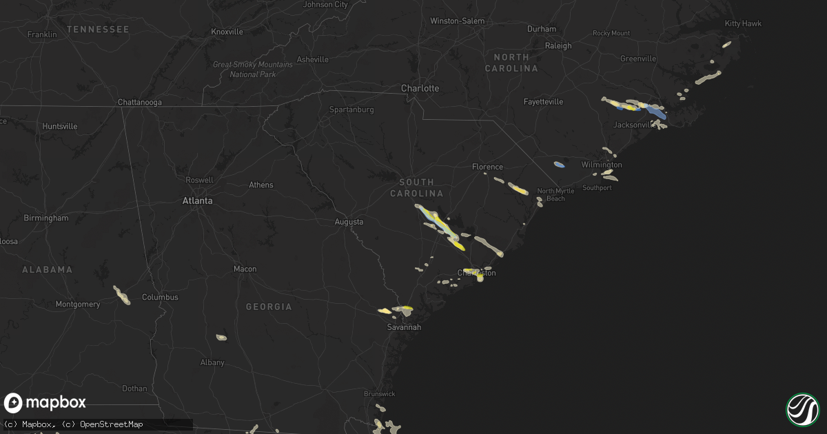
Hail Map in South Carolina on June 15, 2021
Get this storm
June 15 map
$229
one time, instant access
Download today. No call, no setup
Keep the $229
Bought the map and want the full workflow? Apply the entire $229 to a subscription within 7 days. None of it is wasted.
Every map, not just this one
This buys you this map. Subscription and you get every map we run, in the markets you choose from a few cities to whole states to nationwide. Plus real-time alerts the moment a storm fires.
Contact data
Name, contact info, occupancy, even credit band for addresses in the footprint. You go from where it hit to who to call.
Become the source they trust
Unlimited branding weather history reports on demand. You already have the documented answer ready for the property owner, and you are the one who showed up with it.
Property data and RoofTrace estimates
Pull up any address you have got, its value and the exact code rules for that jurisdiction, straight from One Click Code. Then RoofTrace estimates the squares, pitch, and roof value, priced the way you price.
Storm reports in South Carolina
South Carolina
| Date | Description |
|---|---|
| 06/15/20216:51 PM CDT | The public reported 2 trees approximately 1 foot in diameter snapped 10 feet off the ground near the intersection of bimimi drive and bluewater way. |
| 06/15/20216:50 PM CDT | The public reported quarter size hail in grand oak plantation. |
| 06/15/20216:47 PM CDT | Law enforcement reported numerous trees and power lines down along may river road |
| 06/15/20216:45 PM CDT | The public reported a pecan tree uprooted and a small horse shelter blown over. |
| 06/15/20216:40 PM CDT | Measured by nws wind equipment along the south side of lake moultrie. |
| 06/15/20216:39 PM CDT | The public reported a large branch split off a tree near the intersection of highway 52 and 17a. |
| 06/15/20216:31 PM CDT | The public reported a tree down on church road. |
| 06/15/20215:51 PM CDT | Orangeburg county 911 reports widespread trees down across the eastern portion of the county. Operator said they had gotten reports from elloree to eutawville. Time est |
| 06/15/20215:45 PM CDT | Sc highway patrol reports trees down near the intersection of us 176 and us 15. Time estimated from radar. |
| 06/15/20215:41 PM CDT | The orangeburg county emergency manager reports golf ball sized hail near santee. The em also reports significant damage to lake marion high school including damage to |
| 06/15/20215:38 PM CDT | Orangeburg county em reports tree damage along vance road. Reports of tree tops snapped off and multiple trees uprooted. |
| 06/15/20215:33 PM CDT | Sc highway patrol reports trees down near the intersection of us 301 and felderville rd. Time estimated from radar. |
| 06/15/20215:12 PM CDT | Calhoun county dispatch reports widespread trees down across the county. Time estimated from radar. |
| 06/15/20215:05 PM CDT | Sc highway patrol reports trees down near the intersection of belleville rd and moorer rd. Time estimated from radar. |
| 06/15/20215:00 PM CDT | Numerous trees down along burke rd. |
| 06/15/20213:50 PM CDT | The public measured hail the size of a half dollar coin. |
| 06/15/20213:20 PM CDT | Large tree limbs snapped by strong winds in the avalon family community neighborhood in carolina forest. Time of event is radar estimated. |
| 06/15/20212:50 PM CDT | A tree fell across pee dee highway... Near the antioch road intersection. Time of event is radar estimated. |
| 06/15/20213:02 AM CDT | At 801 PM EDT, a severe thunderstorm was located near Adams Run and Fenwick, moving east at 20 mph. HAZARD...60 mph wind gusts and quarter size hail. SOURCE...Radar indicated. IMPACT...Minor hail damage to vehicles is possible. Expect wind damage to trees and powerlines. Locations impacted include... Johns Island, James Island, Hollywood, Folly Beach, Ravenel, Seabrook Island, Kiawah Island, Meggett, Rockville, Bears Bluff, Wadmalaw Island, Yonges Island, Edisto Island, Adams Run and Bennetts Point. |
| 06/15/20212:46 AM CDT | At 746 PM EDT, a severe thunderstorm was located over West Ashley, moving southeast at 20 mph. HAZARD...60 mph wind gusts and quarter size hail. SOURCE...Radar indicated. IMPACT...Minor hail damage to vehicles is possible. Expect wind damage to trees and powerlines. Locations impacted include... North Charleston, Mount Pleasant, Downtown Charleston, West Ashley, Fort Sumter, I-26/I-526 Interchange, Daniel Island, Johns Island, Hollywood, Isle Of Palms, Folly Beach, Ravenel, Sullivan's Island, Sullivans Island and James Island County Park.This warning includes the following interstates: I-26 between mile markers 214 and 221. I-526 between mile markers 11 and 18, and between mile markers 28and 31. |
| 06/15/20212:00 AM CDT | At 700 PM EDT, severe thunderstorms were located along a line extending from near Eadytown to near Holly Hill, moving southeast at 30 mph. HAZARD...60 mph wind gusts and quarter size hail. SOURCE...Radar indicated. IMPACT...Minor hail damage to vehicles is possible. Expect wind damage to trees and powerlines. Locations impacted include... Moncks Corner, Saint Stephen, Bonneau, Southern Lake Moultrie, Eadytown, Cross, Northern Lake Moultrie, Bonneau Beach, Old Santee Canal State Park, Eastern Lake Marion and Pinopolis. |
| 06/15/20211:27 AM CDT | At 626 PM EDT, a severe thunderstorm was located near Elloree, or 12 miles east of Brookdale, moving southeast at 35 mph. HAZARD...60 mph wind gusts and penny size hail. SOURCE...Radar indicated. IMPACT...Expect damage to roofs, siding, and trees. Locations impacted include... Holly Hill, Elloree, Santee State Park, Santee, Cameron, Eutawville, Vance, Poplar Creek Landing, St. Paul, Stumphole Landing, Rocks Pond Campground and Marina, Yonder Field, Eautaw Springs, Indian Bluff Recreation Park, Creston, Blounts Landing, Mill Creek Marina and Campground, Lone Star and Low Falls Landing.This includes the following highways... Interstate 26 between mile markers 156 and 169. Interstate 95 between mile markers 85 and 106. |
| 06/15/202112:59 AM CDT | At 558 PM EDT, a severe thunderstorm was located over St. Matthews, or 8 miles north of Brookdale, moving southeast at 35 mph. HAZARD...60 mph wind gusts and penny size hail. SOURCE...Radar indicated. IMPACT...Expect damage to roofs, siding, and trees. Locations impacted include... St. Matthews, Elloree, Santee State Park, Santee, Cameron, Poplar Creek Landing, St. Paul, Creston, Stumphole Landing, Lone Star and Low Falls Landing.This includes the following highways... Interstate 26 between mile markers 140 and 142. Interstate 95 between mile markers 89 and 106. |
| 06/14/202111:37 PM CDT | At 436 PM EDT, a severe thunderstorm was located near Dorchester, moving southeast at 30 mph. HAZARD...60 mph wind gusts and quarter size hail. SOURCE...Radar indicated. IMPACT...Minor hail damage to vehicles is possible. Expect wind damage to trees and powerlines. Locations impacted include... Summerville, Goose Creek, Moncks Corner, Ladson, Ridgeville, Sangaree, Crowfield Plantation, Jedburg, Old Santee Canal State Park and College Park.This warning includes I-26 between mile markers 182 and 204. |
| 06/14/202110:54 PM CDT | At 353 PM EDT, a severe thunderstorm was located over Pee Dee Crossroads, or 7 miles west of Conway, moving east at 30 mph. HAZARD...60 mph wind gusts and quarter size hail. SOURCE...Radar indicated. IMPACT...Minor hail damage to vehicles is possible. Expect wind damage to trees and power lines. Locations impacted include... Myrtle Beach, Conway, Red Hill, Myrtle Beach Airport, Socastee, Horry, Hickory Grove, Homewood, Horry Georgetown Technical College Conway Campus, Adrian, Pee Dee Crossroads, Nixonville, Dongola, Forestbrook, Hammond, Coastal Carolina University, Lighthouse Care Center Of Conway and Conway Medical Center. |
| 06/14/202110:12 PM CDT | At 311 PM EDT, a severe thunderstorm was located near Pamplico, or 12 miles south of Marion, moving east at 30 mph. HAZARD...60 mph wind gusts and quarter size hail. SOURCE...Radar indicated. IMPACT...Minor hail damage to vehicles is possible. Expect wind damage to trees and power lines. Locations impacted include... Galivants Ferry, Gresham, Brittons Neck, Rains and Aynor. |
| 06/14/20219:37 PM CDT | A trained spotter reported quarter size hail near sunbeam drive. |
| 06/14/20217:38 PM CDT | A 911 call center reported a tree down near the intersection of cottageville hwy and coolers dairy rd and a second tree down along sweat st... With power lines down in |
| 06/14/20217:23 PM CDT | The media reported quarter size hail near the intersection of rifle range road and the iop connector. |
| 06/14/20217:14 PM CDT | The public reported quarter size hail near lighthouse point. |
| 06/14/20217:05 PM CDT | A tree was reported down near river reach way. |
| 06/14/20217:05 PM CDT | The public reported quarter size hail at south windermere |
All States Impacted by Hail Map on June 15, 2021
Cities Impacted by Hail Map on June 15, 2021
- Conway, SC
- Myrtle Beach, SC
- Beaumont, TX
- Clarkson, NE
- Schuyler, NE
- Dayton, TX
- Humble, TX
- Alachua, FL
- Trenton, NC
- Pollocksville, NC
- Arthur, NE
- Charter Oak, IA
- Bandera, TX
- Tuskegee, AL
- Auburn, AL
- Hull, TX
- Wilmington, NC
- Pink Hill, NC
- Port Neches, TX
- Bridge City, TX
- Cameron, LA
- Vidor, TX
- Orange, TX
- Groves, TX
- Port Arthur, TX
- Nederland, TX
- Lumberton, TX
- Houston, TX
- Galena Park, TX
- Kings Bay, GA
- Yulee, FL
- Saint Marys, GA
- Atlantic Beach, FL
- Jacksonville, FL
- Fernandina Beach, FL
- Sour Lake, TX
- Saratoga, TX
- Batson, TX
- Kountze, TX
- Napoleonville, LA
- Labadieville, LA
- Morgan City, LA
- Kaplan, LA
- Gueydan, LA
- Bowman, SC
- Orangeburg, SC
- Santee, SC
- Panama City, FL
- Lynn Haven, FL
- Port Saint Lucie, FL
- Vance, SC
- Holly Hill, SC
- Wewahitchka, FL
- Valdosta, GA
- Guyton, GA
- Lake City, FL
- Grand Chenier, LA
- Creole, LA
- Dequincy, LA
- Elloree, SC
- Bristol, FL
- Shiner, TX
- Gainesville, FL
- Camp Wood, TX
- Uvalde, TX
- Yoakum, TX
- Brooker, FL
- Crawfordville, FL
- Warren, TX
- Folly Beach, SC
- Simla, CO
- Agate, CO
- Fountain, FL
- Blountstown, FL
- Youngstown, FL
- Clarksville, FL
- Shelton, NE
- Ellabell, GA
- Brooklet, GA
- Raton, NM
- Willis, TX
- Conroe, TX
- Baytown, TX
- Liberty, TX
- Eglin Afb, FL
- Galivants Ferry, SC
- Gresham, SC
- Montgomery, TX
- Live Oak, FL
- Fleming Island, FL
- Anahuac, TX
- Wallisville, TX
- Hankamer, TX
- Saint Martinville, LA
- Grosse Tete, LA
- Donaldsonville, LA
- Belle Rose, LA
- Saint James, LA
- Engelhard, NC
- Pamplico, SC
- Greenville, FL
- Inez, TX
- Victoria, TX
- Saint Matthews, SC
- Cameron, SC
- Charleston, SC
- White Springs, FL
- McAlpin, FL
- O'Brien, FL
- Raiford, FL
- Lawtey, FL
- Moscow, ID
- Sopchoppy, FL
- Hosford, FL
- Abbeville, LA
- Milton, FL
- Rocky Point, NC
- Center Tuftonboro, NH
- Ossipee, NH
- Wolfeboro, NH
- Mirror Lake, NH
- Moultonborough, NH
- East Wakefield, NH
- Sanbornville, NH
- Rincon, GA
- Notasulga, AL
- Crosby, TX
- Edna, TX
- Whiteville, NC
- Summerton, SC
- Iola, TX
- Gillett, TX
- Yorktown, TX
- West Newbury, MA
- Haverhill, MA
- Winnabow, NC
- Pine Ridge, SD
- Schleswig, IA
- Green Pond, SC
- Brenham, TX
- Chappell Hill, TX
- Fort Walton Beach, FL
- Mary Esther, FL
- Effingham, SC
- Smiley, TX
- Westhoff, TX
- Pasadena, TX
- Hackberry, LA
- Richmond, TX
- Gibbon, NE
- Starke, FL
- Lake Butler, FL
- Oriental, NC
- Merritt, NC
- Cuero, TX
- Lulu, FL
- Richlands, NC
- Chacon, NM
- Sulphur, LA
- Madison, FL
- San Diego, TX
- Hurlburt Field, FL
- Bedias, TX
- Bellwood, NE
- Devers, TX
- Salisbury, MA
- Newburyport, MA
- Pensacola, FL
- Waldo, FL
- Hawthorne, FL
- Earleton, FL
- Pawleys Island, SC
- Theodore, AL
- Irvington, AL
- Walterboro, SC
- Isle Of Palms, SC
- Mount Pleasant, SC
- Folsom, NM
- Bayboro, NC
- Saucier, MS
- Tallahassee, FL
- Monticello, FL
- Saint Marks, FL
- Cross, SC
- Lee, FL
- Hyannis, NE
- Santa Rosa Beach, FL
- China, TX
- Ridgeville, SC
- Defuniak Springs, FL
- Fort Benton, MT
- Deer Park, TX
- West Newfield, ME
- La Porte, TX
- Webster, TX
- Friendswood, TX
- Micanopy, FL
- Dorchester, SC
- Summerville, SC
- Harleyville, SC
- David City, NE
- Columbia, NC
- Bolivia, NC
- Cypress, TX
- Crowley, LA
- Morse, LA
- Estherwood, LA
- Vernon, FL
- Ponce De Leon, FL
- Ebro, FL
- Amesbury, MA
- Swansboro, NC
- Newport, NC
- Okatie, SC
- Hardeeville, SC
- Elberta, AL
- Freeport, FL
- De Soto, GA
- Ruffin, SC
- Green Cove Springs, FL
- Saint George, GA
- Pinopolis, SC
- Niceville, FL
- Baker, LA
- Baton Rouge, LA
- Katy, TX
- Mico, TX
- Hondo, TX
- McClellanville, SC
- Awendaw, SC
- Rogers, NE
- North Charleston, SC
- Johns Island, SC
- Ravenel, SC
- Gulfport, MS
- Guy, TX
- Boling, TX
- Needville, TX
- Wharton, TX
- Santo Domingo Pueblo, NM
- Convent, LA
- Darrow, LA
- Plattenville, LA
- Sorrento, LA
- Gonzales, LA
- Fort White, FL
- Fairfield, NC
- Lovell, ME
- Stoneham, ME
- Navarre, FL
- Goliad, TX
- Havelock, NC
- Wellborn, FL
- Quitman, GA
- Stella, NC
- Lamont, FL
- Coden, AL
- Mobile, AL
- Bayou La Batre, AL
- Grand Bay, AL
- Fulshear, TX
- Highlands, TX
- Hampstead, NC
- Cobb, GA
- Leslie, GA
- Libby, MT
- Pooler, GA
- Port Wentworth, GA
- Edisto Island, SC
- Jamestown, SC
- Bonneau, SC
- Cordesville, SC
- Moncks Corner, SC
- Huger, SC
- Brookshire, TX
- Waller, TX
- Palatka, FL
- Hockley, TX
- Hollywood, SC
- Lillian, AL
- Porter, TX
- New Caney, TX
- Maurice, LA
- Malvern, IA
- Capulin, NM
- Karnes City, TX
- Ecleto, TX
- Richards, TX
- Kinston, NC
- Mount Olive, NC
- Albertson, NC
- Center Harbor, NH
- Mora, NM
- Wood River, NE
- New Bern, NC
- Bluffton, SC
- Carolina Beach, NC
- Ocate, NM
- Panacea, FL
- Lake Park, GA
- Jennings, FL
- Welsh, LA
- Panama City Beach, FL
- Bell City, LA
- Lake Charles, LA
- Iowa, LA
- Middleburg, FL
- Hampton, FL
- Archer, FL
- Newberry, FL
- Newbury, MA
- Bryceville, FL
- Jacksonville Beach, FL
- Neptune Beach, FL
- Sullivans Island, SC
- Ong, NE
- Edgar, NE
- Meredith, NH
- New Hampton, NH
- Maysville, NC


