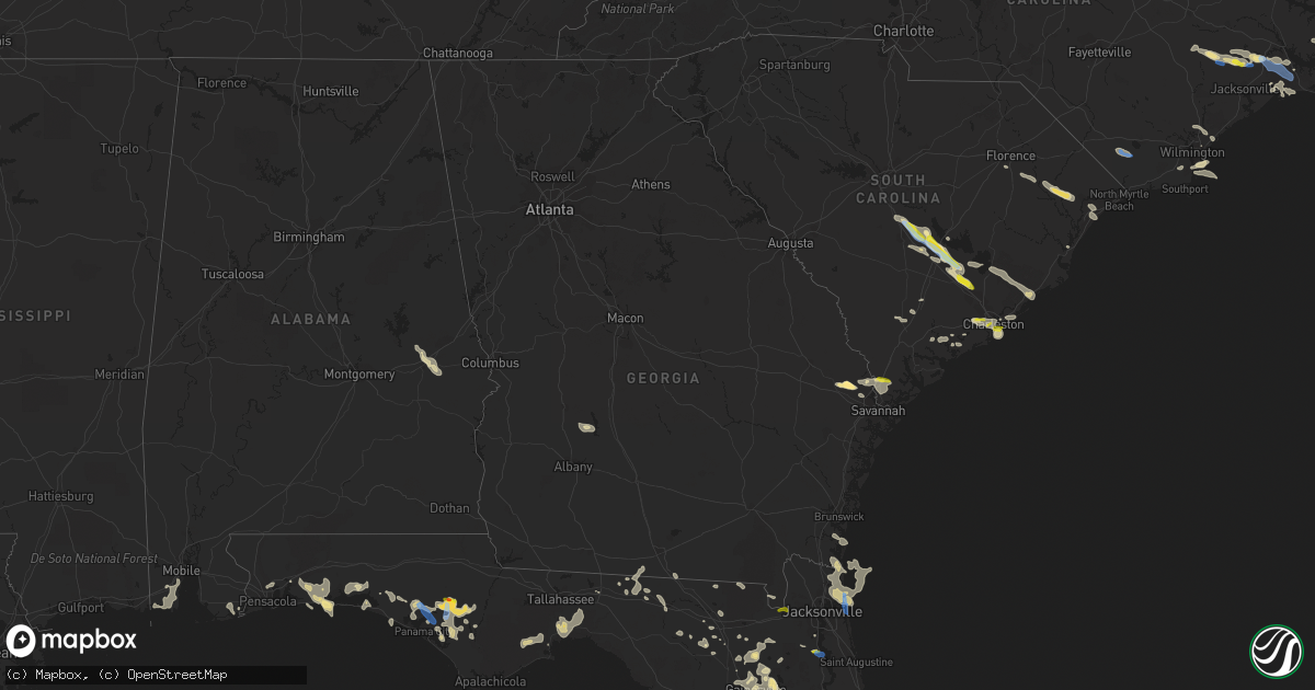
Hail Map in Georgia on June 15, 2021
Get this storm
June 15 map
$229
one time, instant access
Download today. No call, no setup
Keep the $229
Bought the map and want the full workflow? Apply the entire $229 to a subscription within 7 days. None of it is wasted.
Every map, not just this one
This buys you this map. Subscription and you get every map we run, in the markets you choose from a few cities to whole states to nationwide. Plus real-time alerts the moment a storm fires.
Contact data
Name, contact info, occupancy, even credit band for addresses in the footprint. You go from where it hit to who to call.
Become the source they trust
Unlimited branding weather history reports on demand. You already have the documented answer ready for the property owner, and you are the one who showed up with it.
Property data and RoofTrace estimates
Pull up any address you have got, its value and the exact code rules for that jurisdiction, straight from One Click Code. Then RoofTrace estimates the squares, pitch, and roof value, priced the way you price.
Storm reports in Georgia
Georgia
| Date | Description |
|---|---|
| 06/15/20215:35 PM CDT | Em reported multiple trees down along field crossing road between loop road and croxtan road. Some tin was pulled off a chicken house in this area. Time estimated from |
| 06/15/20215:26 AM CDT | At 1026 PM EDT, severe thunderstorms were located along a line extending from near Marlow to near Hardeeville, moving east at 20 mph. HAZARD...60 mph wind gusts and quarter size hail. SOURCE...Radar indicated. IMPACT...Minor hail damage to vehicles is possible. Expect wind damage to trees and powerlines. Locations impacted include... Hilton Head Island, Bluffton, Beaufort, Port Royal, Springfield, Bellinger Hill Area, Godley Station, Savannah International Airport, Jasper, Rincon, Port Wentworth, Hardeeville, Rose Hill, Stillwell and Purysburgh.This warning includes the following interstates: I-95 in South Carolina between mile markers 2 and 17. I-95 in Georgia between mile markers 108 and 112. |
| 06/15/202112:12 AM CDT | At 512 PM EDT, a severe thunderstorm was located near Kings Bay Base, moving southeast at 30 mph. HAZARD...60 mph wind gusts and quarter size hail. SOURCE...Radar indicated. IMPACT...Hail damage to vehicles is expected. Expect wind damage to roofs, siding, and trees. Locations impacted include... St. Marys, Kingsland, Fernandina Beach, Kings Bay Base, Yulee, Cumberland Island and Harrietts Bluff. |
| 06/14/202111:43 PM CDT | At 443 PM EDT, severe thunderstorms were located along a line extending from 10 miles west of Lake Park to 7 miles southwest of Monticello, moving east at 20 mph. HAZARD...60 mph wind gusts and penny size hail. SOURCE...Radar indicated. IMPACT...Expect damage to roofs, siding, and trees. Locations impacted include... Monticello, Madison, Lake Park, Greenville, Lee, Ebb, Lamont, Hamburg, Pinetta, Eridu, Nash, Drifton, Lovett, Nankin, Clyattville, Waukeenah, Hanson, Sirmans, Moseley Hall and Hopewell. |
| 06/14/202111:40 PM CDT | At 440 PM EDT, severe thunderstorms were located along a line extending from near Bryceville to near Taylor to near Belmont, moving southeast at 15 mph. HAZARD...60 mph wind gusts and quarter size hail. SOURCE...Radar indicated. IMPACT...Hail damage to vehicles is expected. Expect wind damage to roofs, siding, and trees. Locations impacted include... Taylor, Macclenny, Glen St. Mary and Belmont. |
| 06/14/202111:18 PM CDT | At 418 PM EDT, a severe thunderstorm was located near Belmont, or 10 miles southwest of Fargo, moving southeast at 5 mph. HAZARD...60 mph wind gusts and quarter size hail. SOURCE...Radar indicated. IMPACT...Hail damage to vehicles is expected. Expect wind damage to roofs, siding, and trees. Locations impacted include... Belmont and Needmore. |
| 06/14/202111:05 PM CDT | At 404 PM EDT, a severe thunderstorm was located 8 miles east of Woodbine, moving southeast at 15 mph. HAZARD...60 mph wind gusts and quarter size hail. SOURCE...Radar indicated. IMPACT...Hail damage to vehicles is expected. Expect wind damage to roofs, siding, and trees. Locations impacted include... Jekyll Island and Dover Bluff. |
| 06/14/20219:17 PM CDT | Emergency manager reported multiple trees and power lines down between the town of guyton and pineora. Time was estimated via radar data. |
| 06/14/20219:14 PM CDT | Golf ball size hail was reported near the intersection of hwy 17 and midland rd. There is one report of siding damage to an adjacent home. The extent of the damage is u |
| 06/14/20217:15 PM CDT | The crisp county emergency manager reported trees and power lines down on rains station road. |
| 06/14/20217:10 PM CDT | The crisp county emergency manager reported power lines down on rockhouse road near i-75. |
All States Impacted by Hail Map on June 15, 2021
Cities Impacted by Hail Map on June 15, 2021
- Conway, SC
- Myrtle Beach, SC
- Beaumont, TX
- Clarkson, NE
- Schuyler, NE
- Dayton, TX
- Humble, TX
- Alachua, FL
- Trenton, NC
- Pollocksville, NC
- Arthur, NE
- Charter Oak, IA
- Bandera, TX
- Tuskegee, AL
- Auburn, AL
- Hull, TX
- Wilmington, NC
- Pink Hill, NC
- Port Neches, TX
- Bridge City, TX
- Cameron, LA
- Vidor, TX
- Orange, TX
- Groves, TX
- Port Arthur, TX
- Nederland, TX
- Lumberton, TX
- Houston, TX
- Galena Park, TX
- Kings Bay, GA
- Yulee, FL
- Saint Marys, GA
- Atlantic Beach, FL
- Jacksonville, FL
- Fernandina Beach, FL
- Sour Lake, TX
- Saratoga, TX
- Batson, TX
- Kountze, TX
- Napoleonville, LA
- Labadieville, LA
- Morgan City, LA
- Kaplan, LA
- Gueydan, LA
- Bowman, SC
- Orangeburg, SC
- Santee, SC
- Panama City, FL
- Lynn Haven, FL
- Port Saint Lucie, FL
- Vance, SC
- Holly Hill, SC
- Wewahitchka, FL
- Valdosta, GA
- Guyton, GA
- Lake City, FL
- Grand Chenier, LA
- Creole, LA
- Dequincy, LA
- Elloree, SC
- Bristol, FL
- Shiner, TX
- Gainesville, FL
- Camp Wood, TX
- Uvalde, TX
- Yoakum, TX
- Brooker, FL
- Crawfordville, FL
- Warren, TX
- Folly Beach, SC
- Simla, CO
- Agate, CO
- Fountain, FL
- Blountstown, FL
- Youngstown, FL
- Clarksville, FL
- Shelton, NE
- Ellabell, GA
- Brooklet, GA
- Raton, NM
- Willis, TX
- Conroe, TX
- Baytown, TX
- Liberty, TX
- Eglin Afb, FL
- Galivants Ferry, SC
- Gresham, SC
- Montgomery, TX
- Live Oak, FL
- Fleming Island, FL
- Anahuac, TX
- Wallisville, TX
- Hankamer, TX
- Saint Martinville, LA
- Grosse Tete, LA
- Donaldsonville, LA
- Belle Rose, LA
- Saint James, LA
- Engelhard, NC
- Pamplico, SC
- Greenville, FL
- Inez, TX
- Victoria, TX
- Saint Matthews, SC
- Cameron, SC
- Charleston, SC
- White Springs, FL
- McAlpin, FL
- O'Brien, FL
- Raiford, FL
- Lawtey, FL
- Moscow, ID
- Sopchoppy, FL
- Hosford, FL
- Abbeville, LA
- Milton, FL
- Rocky Point, NC
- Center Tuftonboro, NH
- Ossipee, NH
- Wolfeboro, NH
- Mirror Lake, NH
- Moultonborough, NH
- East Wakefield, NH
- Sanbornville, NH
- Rincon, GA
- Notasulga, AL
- Crosby, TX
- Edna, TX
- Whiteville, NC
- Summerton, SC
- Iola, TX
- Gillett, TX
- Yorktown, TX
- West Newbury, MA
- Haverhill, MA
- Winnabow, NC
- Pine Ridge, SD
- Schleswig, IA
- Green Pond, SC
- Brenham, TX
- Chappell Hill, TX
- Fort Walton Beach, FL
- Mary Esther, FL
- Effingham, SC
- Smiley, TX
- Westhoff, TX
- Pasadena, TX
- Hackberry, LA
- Richmond, TX
- Gibbon, NE
- Starke, FL
- Lake Butler, FL
- Oriental, NC
- Merritt, NC
- Cuero, TX
- Lulu, FL
- Richlands, NC
- Chacon, NM
- Sulphur, LA
- Madison, FL
- San Diego, TX
- Hurlburt Field, FL
- Bedias, TX
- Bellwood, NE
- Devers, TX
- Salisbury, MA
- Newburyport, MA
- Pensacola, FL
- Waldo, FL
- Hawthorne, FL
- Earleton, FL
- Pawleys Island, SC
- Theodore, AL
- Irvington, AL
- Walterboro, SC
- Isle Of Palms, SC
- Mount Pleasant, SC
- Folsom, NM
- Bayboro, NC
- Saucier, MS
- Tallahassee, FL
- Monticello, FL
- Saint Marks, FL
- Cross, SC
- Lee, FL
- Hyannis, NE
- Santa Rosa Beach, FL
- China, TX
- Ridgeville, SC
- Defuniak Springs, FL
- Fort Benton, MT
- Deer Park, TX
- West Newfield, ME
- La Porte, TX
- Webster, TX
- Friendswood, TX
- Micanopy, FL
- Dorchester, SC
- Summerville, SC
- Harleyville, SC
- David City, NE
- Columbia, NC
- Bolivia, NC
- Cypress, TX
- Crowley, LA
- Morse, LA
- Estherwood, LA
- Vernon, FL
- Ponce De Leon, FL
- Ebro, FL
- Amesbury, MA
- Swansboro, NC
- Newport, NC
- Okatie, SC
- Hardeeville, SC
- Elberta, AL
- Freeport, FL
- De Soto, GA
- Ruffin, SC
- Green Cove Springs, FL
- Saint George, GA
- Pinopolis, SC
- Niceville, FL
- Baker, LA
- Baton Rouge, LA
- Katy, TX
- Mico, TX
- Hondo, TX
- McClellanville, SC
- Awendaw, SC
- Rogers, NE
- North Charleston, SC
- Johns Island, SC
- Ravenel, SC
- Gulfport, MS
- Guy, TX
- Boling, TX
- Needville, TX
- Wharton, TX
- Santo Domingo Pueblo, NM
- Convent, LA
- Darrow, LA
- Plattenville, LA
- Sorrento, LA
- Gonzales, LA
- Fort White, FL
- Fairfield, NC
- Lovell, ME
- Stoneham, ME
- Navarre, FL
- Goliad, TX
- Havelock, NC
- Wellborn, FL
- Quitman, GA
- Stella, NC
- Lamont, FL
- Coden, AL
- Mobile, AL
- Bayou La Batre, AL
- Grand Bay, AL
- Fulshear, TX
- Highlands, TX
- Hampstead, NC
- Cobb, GA
- Leslie, GA
- Libby, MT
- Pooler, GA
- Port Wentworth, GA
- Edisto Island, SC
- Jamestown, SC
- Bonneau, SC
- Cordesville, SC
- Moncks Corner, SC
- Huger, SC
- Brookshire, TX
- Waller, TX
- Palatka, FL
- Hockley, TX
- Hollywood, SC
- Lillian, AL
- Porter, TX
- New Caney, TX
- Maurice, LA
- Malvern, IA
- Capulin, NM
- Karnes City, TX
- Ecleto, TX
- Richards, TX
- Kinston, NC
- Mount Olive, NC
- Albertson, NC
- Center Harbor, NH
- Mora, NM
- Wood River, NE
- New Bern, NC
- Bluffton, SC
- Carolina Beach, NC
- Ocate, NM
- Panacea, FL
- Lake Park, GA
- Jennings, FL
- Welsh, LA
- Panama City Beach, FL
- Bell City, LA
- Lake Charles, LA
- Iowa, LA
- Middleburg, FL
- Hampton, FL
- Archer, FL
- Newberry, FL
- Newbury, MA
- Bryceville, FL
- Jacksonville Beach, FL
- Neptune Beach, FL
- Sullivans Island, SC
- Ong, NE
- Edgar, NE
- Meredith, NH
- New Hampton, NH
- Maysville, NC


