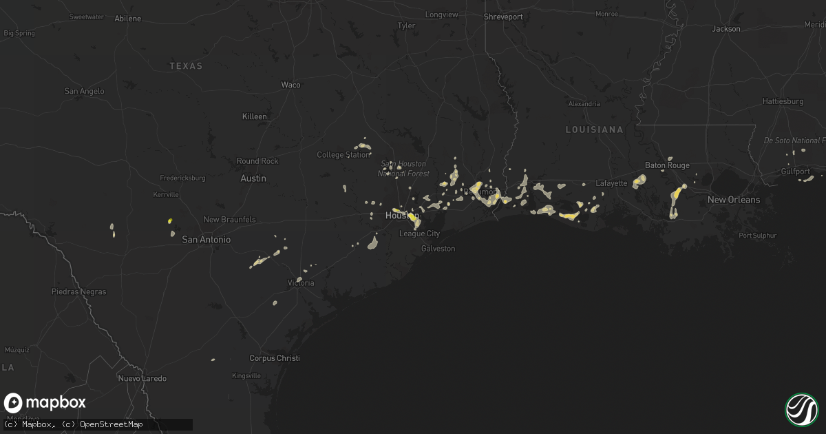
Hail Map on June 15, 2021
Get this storm
June 15 map
$229
one time, instant access
Download today. No call, no setup
Keep the $229
Bought the map and want the full workflow? Apply the entire $229 to a subscription within 7 days. None of it is wasted.
Every map, not just this one
This buys you this map. Subscription and you get every map we run, in the markets you choose from a few cities to whole states to nationwide. Plus real-time alerts the moment a storm fires.
Contact data
Name, contact info, occupancy, even credit band for addresses in the footprint. You go from where it hit to who to call.
Become the source they trust
Unlimited branding weather history reports on demand. You already have the documented answer ready for the property owner, and you are the one who showed up with it.
Property data and RoofTrace estimates
Pull up any address you have got, its value and the exact code rules for that jurisdiction, straight from One Click Code. Then RoofTrace estimates the squares, pitch, and roof value, priced the way you price.
States Impacted by Hail Map on June 15, 2021
Storm reports
Montana
| Date | Description |
|---|---|
| 06/15/20218:20 AM CDT | Fb report. |
| 06/14/20218:30 PM CDT | Report via media on twitter with photo of a large tree branch that smashed a car windshield. |
Maine
| Date | Description |
|---|---|
| 06/15/20214:00 PM CDT | Trees down. |
| 06/14/202111:44 PM CDT | At 444 PM EDT, severe thunderstorms were located along a line extending from 6 miles southeast of Bethel to Waterford to 6 miles northwest of Bridgton, moving east at 15 mph. HAZARD...60 mph wind gusts and quarter size hail. SOURCE...Radar indicated. IMPACT...Hail damage to vehicles is expected. Expect wind damage to roofs, siding, and trees. Locations impacted include... Bridgton, Fryeburg, Bethel, Waterford, Harrison, Denmark, Greenwood, West Paris, Otisfield, Woodstock, Sweden, Norway, Oxford, Paris, Albany and Sumner.This also includes... Long Lake. |
| 06/14/202110:53 PM CDT | At 353 PM EDT, severe thunderstorms were located along a line extending from near Ossipee to near Wolfeboro to 7 miles northwest of Alton, moving northeast at 10 mph. HAZARD...60 mph wind gusts and quarter size hail. SOURCE...Radar indicated. IMPACT...Hail damage to vehicles is expected. Expect wind damage to roofs, siding, and trees. Locations impacted include... Ossipee, Moultonborough, Alton, Effingham, Wolfeboro, Gilford, Acton, Freedom, Brookfield, Eaton, Wakefield, Tuftonboro, Parsonsfield, Porter, Newfield and New Durham. |
Idaho
| Date | Description |
|---|---|
| 06/15/20217:15 AM CDT | A local report indicates 1.00 inch wind near 2 E MOSCOW |
Nebraska
| Date | Description |
|---|---|
| 06/15/20213:49 AM CDT | At 849 AM CDT/749 AM MDT/, a severe thunderstorm was located 7 miles east of Arthur, moving southeast at 20 mph. HAZARD...60 mph wind gusts and half dollar size hail. SOURCE...Radar indicated. IMPACT...Hail damage to vehicles is expected. Expect wind damage to roofs, siding, and trees. Locations impacted include... Bucktail Lake.This includes Highway 92 between mile markers 168 and 174. |
| 06/15/20213:13 AM CDT | At 812 PM CDT, a severe thunderstorm was was centered a few miles northeast of Edgar, or 28 miles southeast of Hastings, and is nearly stationary, but drifting slowly south if anything. HAZARD...Ping pong ball size hail and 60 mph wind gusts. SOURCE...Radar indicated. IMPACT...People and animals outdoors will be injured. Expect hail damage to roofs, siding, windows, and vehicles. Expect wind damage to roofs, siding, and trees. Locations impacted include... Edgar and Ong. |
| 06/15/20212:28 AM CDT | At 727 PM CDT, a severe thunderstorm was located near Shelton, or 17 miles east of Kearney, and is nearly stationary. HAZARD...60 mph wind gusts and quarter size hail. SOURCE...Radar indicated. IMPACT...Hail damage to vehicles is expected. Expect wind damage to roofs, siding, and trees. Locations impacted include... Gibbon and Shelton. This includes Interstate 80 between mile markers 285 and 295. |
| 06/14/202111:59 PM CDT | At 459 AM MDT, a severe thunderstorm was located near Slim Butte, or 16 miles north of Chadron, moving southeast at 20 mph. HAZARD...60 mph wind gusts and quarter size hail. SOURCE...Radar indicated. IMPACT...Hail damage to vehicles is expected. Expect wind damage to roofs, siding, and trees. This severe thunderstorm will remain over mainly rural areas of northeastern Dawes County. |
| 06/14/202111:48 PM CDT | At 448 AM MDT, a severe thunderstorm was located 23 miles north of Ellsworth, or 25 miles southeast of Rushville, moving southeast at 25 mph. HAZARD...60 mph wind gusts and half dollar size hail. SOURCE...Radar indicated. IMPACT...Hail damage to vehicles is expected. Expect wind damage to roofs, siding, and trees. Locations impacted include... Watson Lake, Big Hill, Dipping Vat Meadow, Billys Lake, Wolf Hill, Finnegan Lake and Argo Hill.This includes the following highways... Highway 2 between mile markers 124 and 127. Highway 61 between mile markers 176 and 179. |
| 06/14/202111:32 PM CDT | At 431 AM MDT, a severe thunderstorm was located over Prairie Winds Casino, or 24 miles north of Chadron, moving southeast at 15 mph. HAZARD...Ping pong ball size hail and 60 mph wind gusts. SOURCE...Radar indicated. IMPACT...People and animals outdoors will be injured. Expect hail damage to roofs, siding, windows, and vehicles. Expect wind damage to roofs, siding, and trees. This severe thunderstorm will be near... Prairie Winds Casino around 435 AM MDT.Other locations in the path of this severe thunderstorm include SlimButte and Slim Buttes Housing. |
| 06/14/202110:57 PM CDT | At 357 AM MDT, a severe thunderstorm was located 8 miles south of Rushville, moving southeast at 30 mph. HAZARD...Half dollar size hail. SOURCE...Radar indicated. IMPACT...Damage to vehicles is expected. Locations impacted include... Rushville, Hay Springs, Diamond Lake, Smith Lake State Wildlife Management Area, Highway 250 crossing the Niobrara River, Intersection of Highway 87 and Antelope Road, Walgren Lake State Recreation Area and Argo Hill.This includes the following highways... Highway 20 between mile markers 80 and 94. Highway 250 between mile markers 12 and 48. |
| 06/14/20218:30 PM CDT | Delayed report... Time approximated. Golfball sized hail caused damage to vehicles including breaking windshields. Also damaged crops. |
| 06/14/20217:30 PM CDT | A local report indicates 1.75 inch wind near SHELTON |
| 06/14/20217:25 PM CDT | Fb photo. |
Oregon
| Date | Description |
|---|---|
| 06/15/20217:09 AM CDT | At 1209 AM PDT, a severe thunderstorm was located 9 miles southeast of Dixie, or 14 miles east of Walla Walla, moving north at 45 mph. HAZARD...60 mph wind gusts and quarter size hail. SOURCE...Radar indicated. IMPACT...Hail damage to vehicles is expected. Expect wind damage to roofs, siding, and trees. Locations impacted include... Walla Walla, Dayton, Waitsburg, Dixie, Huntsville, Ski Bluewood and Kooskooskie. |
| 06/14/20219:10 PM CDT | At 209 AM PDT, a severe thunderstorm was located 9 miles northeast of Spout Springs, or 26 miles southeast of Walla Walla, moving north at 40 mph. HAZARD...60 mph wind gusts and quarter size hail. SOURCE...Radar indicated. IMPACT...Hail damage to vehicles is expected. Expect wind damage to roofs, siding, and trees. Locations impacted include... La Grande, Union, Elgin, Island City, Cove, Imbler, Summerville, Minam, Tollgate, Spout Springs, Hilgard and Bingham Springs. |
South Carolina
| Date | Description |
|---|---|
| 06/15/20216:51 PM CDT | The public reported 2 trees approximately 1 foot in diameter snapped 10 feet off the ground near the intersection of bimimi drive and bluewater way. |
| 06/15/20216:50 PM CDT | The public reported quarter size hail in grand oak plantation. |
| 06/15/20216:47 PM CDT | Law enforcement reported numerous trees and power lines down along may river road |
| 06/15/20216:45 PM CDT | The public reported a pecan tree uprooted and a small horse shelter blown over. |
| 06/15/20216:40 PM CDT | Measured by nws wind equipment along the south side of lake moultrie. |
| 06/15/20216:39 PM CDT | The public reported a large branch split off a tree near the intersection of highway 52 and 17a. |
| 06/15/20216:31 PM CDT | The public reported a tree down on church road. |
| 06/15/20215:51 PM CDT | Orangeburg county 911 reports widespread trees down across the eastern portion of the county. Operator said they had gotten reports from elloree to eutawville. Time est |
| 06/15/20215:45 PM CDT | Sc highway patrol reports trees down near the intersection of us 176 and us 15. Time estimated from radar. |
| 06/15/20215:41 PM CDT | The orangeburg county emergency manager reports golf ball sized hail near santee. The em also reports significant damage to lake marion high school including damage to |
| 06/15/20215:38 PM CDT | Orangeburg county em reports tree damage along vance road. Reports of tree tops snapped off and multiple trees uprooted. |
| 06/15/20215:33 PM CDT | Sc highway patrol reports trees down near the intersection of us 301 and felderville rd. Time estimated from radar. |
| 06/15/20215:12 PM CDT | Calhoun county dispatch reports widespread trees down across the county. Time estimated from radar. |
| 06/15/20215:05 PM CDT | Sc highway patrol reports trees down near the intersection of belleville rd and moorer rd. Time estimated from radar. |
| 06/15/20215:00 PM CDT | Numerous trees down along burke rd. |
| 06/15/20213:50 PM CDT | The public measured hail the size of a half dollar coin. |
| 06/15/20213:20 PM CDT | Large tree limbs snapped by strong winds in the avalon family community neighborhood in carolina forest. Time of event is radar estimated. |
| 06/15/20212:50 PM CDT | A tree fell across pee dee highway... Near the antioch road intersection. Time of event is radar estimated. |
| 06/15/20213:02 AM CDT | At 801 PM EDT, a severe thunderstorm was located near Adams Run and Fenwick, moving east at 20 mph. HAZARD...60 mph wind gusts and quarter size hail. SOURCE...Radar indicated. IMPACT...Minor hail damage to vehicles is possible. Expect wind damage to trees and powerlines. Locations impacted include... Johns Island, James Island, Hollywood, Folly Beach, Ravenel, Seabrook Island, Kiawah Island, Meggett, Rockville, Bears Bluff, Wadmalaw Island, Yonges Island, Edisto Island, Adams Run and Bennetts Point. |
| 06/15/20212:46 AM CDT | At 746 PM EDT, a severe thunderstorm was located over West Ashley, moving southeast at 20 mph. HAZARD...60 mph wind gusts and quarter size hail. SOURCE...Radar indicated. IMPACT...Minor hail damage to vehicles is possible. Expect wind damage to trees and powerlines. Locations impacted include... North Charleston, Mount Pleasant, Downtown Charleston, West Ashley, Fort Sumter, I-26/I-526 Interchange, Daniel Island, Johns Island, Hollywood, Isle Of Palms, Folly Beach, Ravenel, Sullivan's Island, Sullivans Island and James Island County Park.This warning includes the following interstates: I-26 between mile markers 214 and 221. I-526 between mile markers 11 and 18, and between mile markers 28and 31. |
| 06/15/20212:00 AM CDT | At 700 PM EDT, severe thunderstorms were located along a line extending from near Eadytown to near Holly Hill, moving southeast at 30 mph. HAZARD...60 mph wind gusts and quarter size hail. SOURCE...Radar indicated. IMPACT...Minor hail damage to vehicles is possible. Expect wind damage to trees and powerlines. Locations impacted include... Moncks Corner, Saint Stephen, Bonneau, Southern Lake Moultrie, Eadytown, Cross, Northern Lake Moultrie, Bonneau Beach, Old Santee Canal State Park, Eastern Lake Marion and Pinopolis. |
| 06/15/20211:27 AM CDT | At 626 PM EDT, a severe thunderstorm was located near Elloree, or 12 miles east of Brookdale, moving southeast at 35 mph. HAZARD...60 mph wind gusts and penny size hail. SOURCE...Radar indicated. IMPACT...Expect damage to roofs, siding, and trees. Locations impacted include... Holly Hill, Elloree, Santee State Park, Santee, Cameron, Eutawville, Vance, Poplar Creek Landing, St. Paul, Stumphole Landing, Rocks Pond Campground and Marina, Yonder Field, Eautaw Springs, Indian Bluff Recreation Park, Creston, Blounts Landing, Mill Creek Marina and Campground, Lone Star and Low Falls Landing.This includes the following highways... Interstate 26 between mile markers 156 and 169. Interstate 95 between mile markers 85 and 106. |
| 06/15/202112:59 AM CDT | At 558 PM EDT, a severe thunderstorm was located over St. Matthews, or 8 miles north of Brookdale, moving southeast at 35 mph. HAZARD...60 mph wind gusts and penny size hail. SOURCE...Radar indicated. IMPACT...Expect damage to roofs, siding, and trees. Locations impacted include... St. Matthews, Elloree, Santee State Park, Santee, Cameron, Poplar Creek Landing, St. Paul, Creston, Stumphole Landing, Lone Star and Low Falls Landing.This includes the following highways... Interstate 26 between mile markers 140 and 142. Interstate 95 between mile markers 89 and 106. |
| 06/14/202111:37 PM CDT | At 436 PM EDT, a severe thunderstorm was located near Dorchester, moving southeast at 30 mph. HAZARD...60 mph wind gusts and quarter size hail. SOURCE...Radar indicated. IMPACT...Minor hail damage to vehicles is possible. Expect wind damage to trees and powerlines. Locations impacted include... Summerville, Goose Creek, Moncks Corner, Ladson, Ridgeville, Sangaree, Crowfield Plantation, Jedburg, Old Santee Canal State Park and College Park.This warning includes I-26 between mile markers 182 and 204. |
| 06/14/202110:54 PM CDT | At 353 PM EDT, a severe thunderstorm was located over Pee Dee Crossroads, or 7 miles west of Conway, moving east at 30 mph. HAZARD...60 mph wind gusts and quarter size hail. SOURCE...Radar indicated. IMPACT...Minor hail damage to vehicles is possible. Expect wind damage to trees and power lines. Locations impacted include... Myrtle Beach, Conway, Red Hill, Myrtle Beach Airport, Socastee, Horry, Hickory Grove, Homewood, Horry Georgetown Technical College Conway Campus, Adrian, Pee Dee Crossroads, Nixonville, Dongola, Forestbrook, Hammond, Coastal Carolina University, Lighthouse Care Center Of Conway and Conway Medical Center. |
| 06/14/202110:12 PM CDT | At 311 PM EDT, a severe thunderstorm was located near Pamplico, or 12 miles south of Marion, moving east at 30 mph. HAZARD...60 mph wind gusts and quarter size hail. SOURCE...Radar indicated. IMPACT...Minor hail damage to vehicles is possible. Expect wind damage to trees and power lines. Locations impacted include... Galivants Ferry, Gresham, Brittons Neck, Rains and Aynor. |
| 06/14/20219:37 PM CDT | A trained spotter reported quarter size hail near sunbeam drive. |
| 06/14/20217:38 PM CDT | A 911 call center reported a tree down near the intersection of cottageville hwy and coolers dairy rd and a second tree down along sweat st... With power lines down in |
| 06/14/20217:23 PM CDT | The media reported quarter size hail near the intersection of rifle range road and the iop connector. |
| 06/14/20217:14 PM CDT | The public reported quarter size hail near lighthouse point. |
| 06/14/20217:05 PM CDT | The public reported quarter size hail at south windermere |
| 06/14/20217:05 PM CDT | A tree was reported down near river reach way. |
Washington
| Date | Description |
|---|---|
| 06/15/20213:30 PM CDT | Walla walla county sheriff confirmed that a small plane not tied down flipped over at martin airfield. |
| 06/15/202110:39 AM CDT | A local report indicates 1.00 inch wind near 6 SW POMEROY |
| 06/15/202110:28 AM CDT | A local report indicates 1.00 inch wind near POMEROY |
| 06/15/20219:10 AM CDT | A local report indicates 1.25 inch wind near 4 N ENDICOTT |
| 06/15/20217:43 AM CDT | At 1242 AM PDT, a severe thunderstorm was located 9 miles northeast of Davenport, or 28 miles northwest of Cheney, moving north at 60 mph. HAZARD...Quarter size hail. Wind gusts up to 45 MPH. SOURCE...Radar indicated. IMPACT...Damage to vehicles is expected. Locations impacted include... Chewelah, Davenport, Gravelles, Little Falls Dam, Wellpinit and Mondovi. |
| 06/14/202110:00 PM CDT | At 300 AM PDT, a severe thunderstorm was located 9 miles south of Newport, or 13 miles southwest of Priest River, moving northeast at 70 mph. HAZARD...60 mph wind gusts and quarter size hail. SOURCE...Radar indicated. IMPACT...Hail damage to vehicles is expected. Wind damage is possible as well. Locations impacted include... Priest River, Deer Park, Newport, Oldtown, Milan, Diamond Lake, Elk, Bead Lake Campground, South Skookum Lake Campground, Mount Spokane, Sacheen Lake and Dalkena. |
Massachusetts
| Date | Description |
|---|---|
| 06/15/20215:00 PM CDT | A local report indicates 1.00 inch wind near 6 SSE SEABROOK |
| 06/15/20214:45 PM CDT | Cocorahs observer |
| 06/15/20214:34 PM CDT | Reported from a farm on hampstead road in methuen. |
| 06/15/202112:14 AM CDT | At 514 PM EDT, severe thunderstorms were located along a line extending from near Brentwood to Pelham, moving east at 30 mph. HAZARD...60 mph wind gusts and quarter size hail. SOURCE...Radar indicated. IMPACT...Hail damage to vehicles is expected. Expect wind damage to roofs, siding, and trees. Locations impacted include... Derry, Hampton, Exeter, Salem, Brentwood, Greenland, Seabrook, Pelham, Rye, Stratham, Hudson, Hampstead, Atkinson, Kingston, Chester, Danville, Fremont, East Kingston, Hampton Falls and Kensington.This includes the following highways... Interstate 93 between mile markers 0 and 8. Interstate 95 in New Hampshire between mile markers 0 and 8.This also includes... Hampton Beach. |
| 06/14/202111:36 PM CDT | At 435 PM EDT, severe thunderstorms were located along a line extending from near Auburn to near Hollis, moving east at 15 mph. HAZARD...60 mph wind gusts and nickel size hail. SOURCE...Radar indicated. IMPACT...Expect damage to roofs, siding, and trees. Locations impacted include... Manchester, Nashua, Derry, Exeter, Merrimack, Salem, Bedford, Litchfield, Hollis, Brentwood, Hudson, Pelham, Raymond, Londonderry, Hampstead, Atkinson, Kingston, Chester, Danville and Fremont.This includes the following highways... Interstate 293 between mile markers 1 and 2. Interstate 93 between mile markers 1 and 21. |
Arizona
| Date | Description |
|---|---|
| 06/15/20213:39 AM CDT | At 839 PM MST, a severe thunderstorm was located over Paradise Valley, moving southwest at 45 mph. HAZARD...60 mph wind gusts. SOURCE...Radar indicated. IMPACT...Expect damage to roofs, siding, and trees. Locations impacted include... Phoenix, Scottsdale, Paradise Valley, Piestewa Peak Park, Downtown Scottsdale, Scottsdale Airport and Camelback Mountain. |
Virginia
| Date | Description |
|---|---|
| 06/15/202112:49 AM CDT | At 549 AM EDT, a severe thunderstorm was located over Exmore, moving east at 40 mph. HAZARD...60 mph wind gusts. SOURCE...Radar indicated. IMPACT...Expect damage to trees and powerlines. This severe thunderstorm will remain over mainly rural areas of southern Accomack and northern Northampton Counties, including the following locations... Melfa, Pungoteague, Jamesville, Painter, Keller, Quinby, Wachapreague and Wardtown. |
Alabama
| Date | Description |
|---|---|
| 06/14/20218:48 PM CDT | At 148 PM CDT, a severe thunderstorm was located 4 miles south of Theodore, moving south at 15 mph. HAZARD...60 mph wind gusts and penny size hail. SOURCE...Radar indicated. IMPACT...Expect damage to roofs, siding, and trees. Locations impacted include... Theodore, Bayou La Batre, Coden and Alabama Port. |
Mississippi
| Date | Description |
|---|---|
| 06/14/202111:08 PM CDT | At 408 PM CDT, a severe thunderstorm was located 10 miles north of Latimer, or 14 miles north of Biloxi, moving south at 10 mph. HAZARD...60 mph wind gusts and nickel size hail. SOURCE...Radar indicated. IMPACT...Expect damage to roofs, siding, and trees. Locations impacted include... Gulfport, Biloxi, Ocean Springs, Long Beach, St. Martin, D'iberville, Saucier, Latimer, Lyman, Gulf Hills and Gulfport Airport.This includes the following Interstates... Interstate 10 in Mississippi between mile markers 23 and 51. Interstate 110 in Mississippi near mile marker 1, and between milemarkers 3 and 4. |
Louisiana
| Date | Description |
|---|---|
| 06/15/202112:27 AM CDT | At 527 PM CDT, severe thunderstorms were located along a line extending from Napoleonville to near Labadieville, moving south at 20 mph. HAZARD...60 mph wind gusts and quarter size hail. SOURCE...Radar indicated. IMPACT...Hail damage to vehicles is expected. Expect wind damage to roofs, siding, and trees. Locations impacted include... Napoleonville, Supreme, Labadieville, Paincourtville, Schriever and Belle Rose. |
| 06/15/202112:08 AM CDT | At 507 PM CDT, a severe thunderstorm was located over Port Acres, or near Nederland, moving southwest at 30 mph. HAZARD...60 mph wind gusts and quarter size hail. SOURCE...Radar indicated. IMPACT...Hail damage to vehicles is expected. Expect wind damage to roofs, siding, and trees. Locations impacted include... Beaumont, Port Arthur, Nederland, Groves, Port Neches, Sabine Pass, Central Gardens, La Belle, Port Acres, Southeast Texas Regional Airport and Sea Rim State Park. |
| 06/14/202111:54 PM CDT | At 453 PM CDT, a severe thunderstorm was located near Bridge City, moving southwest at 30 mph. HAZARD...60 mph wind gusts and quarter size hail. SOURCE...Radar indicated. IMPACT...Hail damage to vehicles is expected. Expect wind damage to roofs, siding, and trees. Locations impacted include... Beaumont, Port Arthur, Orange, Nederland, Groves, Port Neches, Vidor, Bridge City, West Orange, Mauriceville, Rose City, Pine Forest, Lakeview, Pinehurst, Forest Heights and Orangefield.This includes Interstate 10 in Texas between mile markers 879 and856. |
| 06/14/202111:50 PM CDT | At 450 PM CDT, a severe thunderstorm was located over Belle Rose, or over Donaldsonville, moving southwest at 15 mph. HAZARD...60 mph wind gusts and half dollar size hail. SOURCE...Radar indicated. IMPACT...Hail damage to vehicles is expected. Expect wind damage to roofs, siding, and trees. Locations impacted include... Donaldsonville, Napoleonville, Supreme, Paincourtville and Belle Rose. |
| 06/14/202111:18 PM CDT | At 418 PM CDT, severe thunderstorms were located along a line extending from near Gonzales to Sorrento to 6 miles north of Lutcher, moving south at 15 mph. HAZARD...60 mph wind gusts and half dollar size hail. SOURCE...Radar indicated. IMPACT...Hail damage to vehicles is expected. Expect wind damage to roofs, siding, and trees. Locations impacted include... Gonzales, Donaldsonville, Gramercy, Lutcher, Sorrento, Wallace, Convent, North Vacherie, Garyville, Geismar, Belle Rose and Edgard.This includes Interstate 10 in Louisiana between mile markers 177 and198. |
| 06/14/202110:50 PM CDT | At 350 PM CDT, a severe thunderstorm was located over Whitehall, or 14 miles northwest of Reserve, moving south at 5 mph. HAZARD...60 mph wind gusts and nickel size hail. SOURCE...Radar indicated. IMPACT...Expect damage to roofs, siding, and trees. Locations impacted include... Reserve, Laplace, Gramercy, Lutcher, French Settlement, Garyville, Whitehall and Killian.This includes Interstate 10 in Louisiana between mile markers 186 and204. |
New Jersey
| Date | Description |
|---|---|
| 06/15/20217:12 AM CDT | At 1212 AM EDT, a severe thunderstorm was located near Mizpah, or 9 miles northeast of Vineland, moving east at 25 mph. HAZARD...60 mph wind gusts and quarter size hail. SOURCE...Radar indicated. IMPACT...Minor damage to vehicles is possible. Wind damage to roofs, siding, trees, and power lines is possible. Locations impacted include... Atlantic City, Pleasantville, Hammonton, Brigantine, Absecon, Buena, Egg Harbor City, Weymouth, Estell Manor, Newfield, Port Republic, Pomona, Mays Landing, Elwood-Magnolia, Wading River, Bass River State Forest, Batsto, Mizpah, New Gretna and Mystic Island.This includes the following highways... Garden State Parkway between mile markers 38 and 55. Atlantic City Expressway between mile markers 7 and 28. |
Texas
| Date | Description |
|---|---|
| 06/15/20216:50 PM CDT | Mesonet station xcrb crab lake. |
| 06/15/20216:45 PM CDT | Roof of industrial building sustained significant damage due to thunderstorm wind gusts. |
| 06/15/20216:40 PM CDT | A local report indicates 1.00 inch wind near 4 NNW DEER PARK |
| 06/15/20216:27 PM CDT | Roof damage to industrial building due to thunderstorm wind gusts. |
| 06/15/20216:27 PM CDT | Roof damage to industrial building as a result of thunderstorm wind gusts. |
| 06/15/20216:26 PM CDT | Report from mping: quarter |
| 06/15/20216:07 PM CDT | Pea to quarter sized hail reported in the garden oaks/oak forest neighborhood. |
| 06/15/20216:01 PM CDT | Report from mping: quarter |
| 06/15/20216:00 PM CDT | A local report indicates 1.00 inch wind near 4 ENE HILSHIRE VILLAGE |
| 06/15/20216:00 PM CDT | Quarter size hail. |
| 06/15/20215:58 PM CDT | Report from mping: quarter |
| 06/15/20215:50 AM CDT | At 1049 PM CDT, a severe thunderstorm was located near Laguna, or 20 miles northwest of Uvalde, moving south at 15 mph. HAZARD...60 mph wind gusts and quarter size hail. SOURCE...Radar indicated. IMPACT...Hail damage to vehicles is expected. Expect wind damage to roofs, siding, and trees. Locations impacted include... Uvalde, Laguna, Reagan Wells, Montell, Cline and Uvalde Estates. |
| 06/15/20212:53 AM CDT | At 752 PM CDT, a severe thunderstorm was located near Bandera, moving southwest at 10 mph. HAZARD...60 mph wind gusts and nickel size hail. SOURCE...Radar indicated. IMPACT...Expect damage to roofs, siding, and trees. Locations impacted include... Bandera, Hill Country State Natural Area, Bandera Falls, Lakehills and Lake Medina Shores. |
| 06/15/20212:33 AM CDT | At 733 PM CDT, a severe thunderstorm was located near Bedias, or 16 miles south of Madisonville, moving west at 15 mph. HAZARD...60 mph wind gusts and quarter size hail. SOURCE...Trained weather spotters. IMPACT...Hail damage to vehicles is expected. Expect wind damage to roofs, siding, and trees. Locations impacted include... Eastern College Station, eastern Bryan, Bedias, Wixon Valley, Iola and Carlos. |
| 06/15/20212:14 AM CDT | At 714 PM CDT, a severe thunderstorm was located over Deer Park, moving southeast at 10 mph. HAZARD...60 mph wind gusts and quarter size hail. SOURCE...Radar indicated. IMPACT...Hail damage to vehicles is expected. Expect wind damage to roofs, siding, and trees. Locations impacted include... Pasadena, northern League City, southern Baytown, La Porte, Deer Park, South Houston, Seabrook, Webster, Beach City, Kemah, Clear Lake, eastern South Belt / Ellington, Nassau Bay, Taylor Lake Village, El Lago, Shoreacres, Clear Lake Shores, Morgan's Point, The Johnson Space Center and Ellington Field. |
| 06/15/20212:02 AM CDT | At 700 PM CDT, severe thunderstorms were located along a line extending from near Baytown to Crystal Beach. Movement was southwest at 30 mph. Strong outflow winds can be expected in advance of the main line of storms as well. HAZARD...60 mph wind gusts. SOURCE...Radar indicated. IMPACT...Expect damage to roofs, siding, and trees. Locations impacted include... League City, Galveston Causeway, Galveston Island West End, Texas City, southern Friendswood, Dickinson, La Marque, Santa Fe, Webster, Hitchcock, Kemah, Galveston Pier 21, Nassau Bay, Bayou Vista, Clear Lake Shores, Jamaica Beach, Tiki Island, San Leon, Scholes Field and Port Bolivar. |
| 06/15/20211:28 AM CDT | At 628 PM CDT, a severe thunderstorm was located over eastern Houston Ship Channel, or near Cloverleaf, moving southeast at 20 mph. HAZARD...60 mph wind gusts and quarter size hail. SOURCE...Radar indicated. IMPACT...Hail damage to vehicles is expected. Expect wind damage to roofs, siding, and trees. Locations impacted include... Pasadena, Baytown, La Porte, Deer Park, Seabrook, Galena Park, Jacinto City, Beach City, Kemah, Cloverleaf, Channelview, Second Ward, Highlands, Greater Fifth Ward, northern Clear Lake, Taylor Lake Village, El Lago, Shoreacres, Clear Lake Shores and Morgan's Point. |
| 06/15/202112:57 AM CDT | At 557 PM CDT, a severe thunderstorm was located over Central Northwest, or over Greater Heights, moving southeast at 10 mph. HAZARD...60 mph wind gusts and penny size hail. SOURCE...Radar indicated. IMPACT...Expect damage to roofs, siding, and trees. Locations impacted include... Bellaire, West University Place, Galena Park, Jacinto City, Hunters Creek Village, Piney Point Village, Midtown Houston, Downtown Houston, Northside / Northline, Greenway / Upper Kirby Area, Second Ward, Greater Heights, Neartown / Montrose, Greater Eastwood, Near Northside Houston, Greater Fifth Ward, Memorial Park, Greater Third Ward, Fourth Ward and University Place. |
| 06/15/202112:39 AM CDT | At 538 PM CDT, severe thunderstorms were located along a line extending from near Sour Lake to near Bevil Oaks to near Beaumont to near La Belle, moving southwest at 15 mph. HAZARD...60 mph wind gusts and quarter size hail. SOURCE...Radar indicated. IMPACT...Hail damage to vehicles is expected. Expect wind damage to roofs, siding, and trees. Locations impacted include... Beaumont, Sour Lake, Nome, Hamshire, Bevil Oaks, China and Fannett.This includes Interstate 10 in Texas between mile markers 853 and832. |
| 06/15/202112:37 AM CDT | At 536 PM CDT, a severe thunderstorm was located near Gillett, or 13 miles northwest of Yorktown, moving southwest at 25 mph. HAZARD...60 mph wind gusts and quarter size hail. SOURCE...Radar indicated. IMPACT...Hail damage to vehicles is expected. Expect wind damage to roofs, siding, and trees. Locations impacted include... Kenedy, Karnes City, Runge, Falls City, Cestohowa, Hobson, Cotton Patch, Gruenau, New Davy, Ecleto, Helena and Pana Maria. |
| 06/14/202111:48 PM CDT | At 448 PM CDT, a severe thunderstorm was located near Sabine National Wildlife, moving southwest at 20 mph. HAZARD...60 mph wind gusts and penny size hail. SOURCE...Radar indicated. IMPACT...Expect damage to roofs, siding, and trees. Locations impacted include... Cameron, Johnsons Bayou, Sabine National Wildlife, Holly Beach, Hackberry and Constance Beach. |
| 06/14/202111:29 PM CDT | At 428 PM CDT, a severe thunderstorm was located near Sabine National Wildlife, moving southwest at 20 mph. HAZARD...60 mph wind gusts and penny size hail. SOURCE...Radar indicated. IMPACT...Expect damage to roofs, siding, and trees. Locations impacted include... Sabine National Wildlife, Hackberry and Constance Beach. |
| 06/14/20217:55 PM CDT | Mostly dime to nickel sized hail with a few hailstones up to quarter sized. |
| 06/14/20217:52 PM CDT | Downed power lines due to strong winds. |
| 06/14/20217:35 PM CDT | Public reported a measured wind speed of 62 mph... With a power outage shortly after. Also noted some downed trees. |
| 06/14/20217:02 PM CDT | Weatherflow crab lake site. |
Florida
| Date | Description |
|---|---|
| 06/15/20215:05 PM CDT | 911 call center reported a tree down near the intersection of east buffalo bluff rd & cove drive. Time estimate based on radar. |
| 06/15/20215:01 PM CDT | Mesonet station xjak jacksonville. |
| 06/15/20214:40 PM CDT | Tree down on ne lantana street. |
| 06/15/20214:35 PM CDT | 911 call center reported a tree down at 2643 nw 13th st |
| 06/15/20214:35 PM CDT | 911 call center reported a tree was knocked down. |
| 06/15/20214:30 PM CDT | 911 call center reported a tree down near the intersection of northwest 15th place & fort clarke boulevard. Time estimate based on radar. |
| 06/15/20214:30 PM CDT | 911 call center reported a tree and power line down near the 5900 block of east university avenue. Time estimate based on radar. |
| 06/15/20214:20 PM CDT | 911 call center reported a tree was knocked down. |
| 06/15/20214:18 PM CDT | 911 call center reported a tree was knocked down. |
| 06/15/20214:10 PM CDT | 911 call center reported a tree was knocked down. |
| 06/15/20214:05 PM CDT | Trained spotter reported a tree was knocked down. |
| 06/15/20214:02 PM CDT | 911 call center reported multiple trees down. |
| 06/15/20213:55 PM CDT | 911 call center reported a tree was knocked down. |
| 06/15/20213:30 PM CDT | Report of trees down in northern gulf county. |
| 06/15/20213:27 PM CDT | Fallen trees or limbs resulted in a power outage in the saint marks areas as reported on the duke energy outage map. |
| 06/15/20213:26 PM CDT | Received a report on social media of a tree knocked down. |
| 06/15/20213:25 PM CDT | 911 call center reported a tree down near the intersection of nw 180th st & northwest 75th avenue. Time estimate based on radar. |
| 06/15/20213:20 PM CDT | 911 call center reported a tree down near the intersection of nw cr 229 and cr 229a. Time estimate based on radar. |
| 06/15/20213:15 PM CDT | Corrects time of previous tstm wnd dmg report from newport. 911 call center reported multiple trees down. |
| 06/15/20213:15 PM CDT | Fallen trees or limbs resulted in a power outage near woodville highway and shadeville road as reported by duke energy. |
| 06/15/20213:10 PM CDT | Corrects previous hail report from 1 ne new river. Corrects previous hail report from 1 ne new river. Storm spotter called in a report of quarter size hail falling at h |
| 06/15/20213:10 PM CDT | **correction** storm spotter called in a report of quarter size hail falling at his residence near the intersection of cr 235 and sr100. |
| 06/15/20212:59 PM CDT | Received a report of golf ball size hail along the bay/calhoun county line along highway 20. |
| 06/15/20212:44 PM CDT | Spotter reports measured wind gust of 59 mph near youngstown. |
| 06/15/20212:30 PM CDT | Report of estimated 70 mph wind gust near cherokee landing. |
| 06/15/20212:30 PM CDT | Social media report of dime to quarter size hail in northern bay county east of highway 231. |
| 06/15/20212:25 PM CDT | 911 call center reported a tree down near the intersection of 256th st & 41st rd. Time estimate based on radar. |
| 06/15/20212:20 PM CDT | 911 call center reported a tree down near the intersection of sr 247 & cr 137. Time estimate based on radar. |
| 06/15/20212:15 PM CDT | 911 call center reported a tree down near the intersection of 180th st and 89th rd. Time estimate based on radar. |
| 06/15/20212:15 PM CDT | 911 call center reported a tree down near the intersection of co rd 137 & hogan rd. Time estimate based on radar. |
| 06/15/20212:15 PM CDT | Social media report of quarter sized hail in southwestern calhoun county. |
| 06/15/20212:10 PM CDT | 911 call center reported a tree down near the intersection of 164th rd and 161st rd. Time estimate based on radar. |
| 06/15/20212:00 PM CDT | Lauderhill fire department reported a palm tree that was toppled onto a multi-story apartment building during a strong thunderstorm. Video shows that the ground was sat |
| 06/15/20211:56 PM CDT | Spotter measured wind gusts of 60 mph near crystal lake. |
| 06/15/20213:58 AM CDT | At 858 PM EDT, a severe thunderstorm was located 9 miles southeast of Williston, moving southeast at 30 mph. HAZARD...60 mph wind gusts and penny size hail. SOURCE...Radar indicated. IMPACT...Expect damage to roofs, siding, and trees. Locations impacted include... Ocala, Sparr, Anthony, Ocala Airport, Reddick, Flemington, Lowell and Burbank. |
| 06/15/20211:34 AM CDT | At 634 PM EDT, a severe thunderstorm was located near Mayo, moving south at 35 mph. HAZARD...60 mph wind gusts. SOURCE...Radar indicated. IMPACT...Expect damage to roofs, siding, and trees. Locations impacted include... Mayo, Hatch Bend, San Pedro Junction, Alton, Grady and Fletcher Springs. |
| 06/15/20211:17 AM CDT | At 617 PM EDT, a severe thunderstorm was located near Suwannee Valley, or near White Springs, moving southeast at 20 mph. HAZARD...60 mph wind gusts and quarter size hail. SOURCE...Radar indicated. IMPACT...Hail damage to vehicles is expected. Expect wind damage to roofs, siding, and trees. Locations impacted include... Lake City, Palestine Community, Groves, Five Points, Watertown, Lulu, Winfield, Olustee and Suwannee Valley. |
| 06/15/20211:01 AM CDT | At 601 PM EDT, a severe thunderstorm was located over Little Talbot Island, or 11 miles northeast of Unf, moving south at 20 mph. HAZARD...60 mph wind gusts and quarter size hail. SOURCE...Radar indicated. IMPACT...Hail damage to vehicles is expected. Expect wind damage to roofs, siding, and trees. Locations impacted include... Unf, Ponte Vedra Beach, Neptune Beach, Palm Valley, Sawgrass, Bayard, Craig Field, San Pablo, Little Talbot Island and Fort Caroline. |
| 06/15/202112:57 AM CDT | At 557 PM EDT, a severe thunderstorm was located 7 miles south of University Of Florida, or 9 miles south of Gainesville, moving east at 25 mph. HAZARD...60 mph wind gusts and quarter size hail. SOURCE...Radar indicated. IMPACT...Hail damage to vehicles is expected. Expect wind damage to roofs, siding, and trees. Locations impacted include... Fort McCoy, Citra, Hawthorne, Archer, University Of Florida, Sparr, Rochelle, Cross Creek, Orange Springs and Micanopy. |
| 06/15/202112:54 AM CDT | At 554 PM EDT, a severe thunderstorm was located near Suwannee River State Park, moving east at 25 mph. HAZARD...70 mph wind gusts and quarter size hail. SOURCE...Radar indicated. IMPACT...Hail damage to vehicles is expected. Expect considerable tree damage. Wind damage is also likely to mobile homes, roofs, and outbuildings. Locations impacted include... Live Oak, White Springs, Suwannee Springs, Suwannee River State Park, Dowling Park, Mcalpin, Luraville, Newburn and Houston. |
| 06/15/202112:46 AM CDT | At 546 PM EDT, a severe thunderstorm was located over East Palatka, moving east at 25 mph. HAZARD...60 mph wind gusts and quarter size hail. SOURCE...Radar indicated. IMPACT...Hail damage to vehicles is expected. Expect wind damage to roofs, siding, and trees. Locations impacted include... Palatka, Bunnell, Pomona Park, Hastings, East Palatka, Andalusia, Orange Mills, Bardin, San Mateo and Satsuma. |
| 06/15/202112:36 AM CDT | At 536 PM EDT, a severe thunderstorm was located near Little Talbot Island, or 14 miles south of Fernandina Beach, moving southwest at 15 mph. HAZARD...60 mph wind gusts and quarter size hail. SOURCE...Radar indicated. IMPACT...Hail damage to vehicles is expected. Expect wind damage to roofs, siding, and trees. Locations impacted include... Unf, Ponte Vedra Beach, Neptune Beach, Sawgrass, Baymeadows, Nocatee, Craig Field, San Pablo, Little Talbot Island and Fort Caroline. |
| 06/15/202112:35 AM CDT | At 535 PM EDT, a severe thunderstorm was located near Melrose, moving southeast at 20 mph. HAZARD...70 mph wind gusts and quarter size hail. SOURCE...Radar indicated. IMPACT...Hail damage to vehicles is expected. Expect considerable tree damage. Wind damage is also likely to mobile homes, roofs, and outbuildings. Locations impacted include... Interlachen, Melrose, Hawthorne, George's Lake, Lake Geneva, Florahome, Melrose Landing, Orange Heights, Hollister and Waldo. |
| 06/15/202112:30 AM CDT | At 529 PM EDT, severe thunderstorms were located along a line extending from 8 miles northeast of Suwannee Valley to near Madison, moving southeast at 45 mph. HAZARD...60 mph wind gusts and quarter size hail. SOURCE...Radar indicated. IMPACT...Hail damage to vehicles is expected. Expect wind damage to roofs, siding, and trees. Locations impacted include... Lake City, Live Oak, White Springs, Suwannee River State Park, Suwannee Springs, Winfield, Suwannee Valley, Mcalpin, Luraville and Wellborn. |
| 06/15/202112:26 AM CDT | At 526 PM EDT, severe thunderstorms were located along a line extending from near Cecil Field to 7 miles northeast of Five Points, moving southeast at 15 mph. HAZARD...60 mph wind gusts and quarter size hail. SOURCE...Radar indicated. IMPACT...Hail damage to vehicles is expected. Expect wind damage to roofs, siding, and trees. Locations impacted include... Macclenny, Glen St. Mary, Cecil Field, Maxville, Olustee, Sanderson, Oakleaf Plantation, Lakeside and Baldwin. |
| 06/15/202112:15 AM CDT | At 515 PM EDT, a severe thunderstorm was located near Gainesville, moving east at 30 mph. HAZARD...60 mph wind gusts and quarter size hail. SOURCE...Radar indicated. IMPACT...Hail damage to vehicles is expected. Expect wind damage to roofs, siding, and trees. Locations impacted include... Gainesville, Alachua, High Springs, University Of Florida, Gainesville Airport, Newnans Lake, Rochelle, Newberry, Waldo and Grove Park. |
| 06/15/202112:09 AM CDT | At 509 PM EDT, a severe thunderstorm was located near Bryceville, or 19 miles southwest of Callahan, moving southeast at 15 mph. HAZARD...50 mph wind gusts and quarter size hail. SOURCE...Radar indicated. IMPACT...Hail damage to vehicles is expected. Expect wind damage to roofs, siding, and trees. Locations impacted include... Bryceville, Baldwin and Whitehouse Air Field. |
| 06/15/202112:07 AM CDT | At 506 PM EDT, a severe thunderstorm was located near Green Cove Springs, moving northeast at 15 mph. HAZARD...60 mph wind gusts and quarter size hail. SOURCE...Radar indicated. IMPACT...Hail damage to vehicles is expected. Expect wind damage to roofs, siding, and trees. Locations impacted include... Orange Park, Green Cove Springs, Mandarin, Fruit Cove, Fleming Island, Switzerland, Penney Farms and Asbury Lake. |
| 06/14/202111:54 PM CDT | At 454 PM EDT, severe thunderstorms located near Hilliard, moving southeast at 15 mph. HAZARD...60 mph wind gusts and quarter size hail. SOURCE...Radar indicated. IMPACT...Hail damage to vehicles is expected. Expect wind damage to roofs, siding, and trees. Locations impacted include... Callahan, Ratliff and Nassau Village-Ratliff. |
| 06/14/202111:47 PM CDT | At 447 PM EDT, a severe thunderstorm was located over Jennings, moving southeast at 5 mph. HAZARD...60 mph wind gusts and quarter size hail. SOURCE...Radar indicated. IMPACT...Hail damage to vehicles is expected. Expect wind damage to roofs, siding, and trees. This severe thunderstorm will be near... Crossroads around 505 PM EDT. Jasper around 530 PM EDT. |
| 06/14/202111:45 PM CDT | At 445 PM EDT, a severe thunderstorm was located over Orange Heights, or near Melrose, moving east at 15 mph. HAZARD...60 mph wind gusts and quarter size hail. SOURCE...Radar indicated. IMPACT...Hail damage to vehicles is expected. Expect wind damage to roofs, siding, and trees. Locations impacted include... Interlachen, Keystone Heights, Melrose, Melrose Landing, Orange Heights, Lake Geneva, Florahome, Waldo, Putnam Hall and Mannville. |
| 06/14/202111:33 PM CDT | At 433 PM EDT, a severe thunderstorm was located 7 miles southwest of St. George, or 20 miles west of Callahan, moving southeast at 15 mph. HAZARD...60 mph wind gusts and quarter size hail. SOURCE...Radar indicated. IMPACT...Hail damage to vehicles is expected. Expect wind damage to roofs, siding, and trees. Locations impacted include... St. George. |
| 06/14/202111:24 PM CDT | At 423 PM EDT/323 PM CDT/, a severe thunderstorm was located near Mexico Beach, or near Port St. Joe, moving southeast at 30 mph. HAZARD...60 mph wind gusts and quarter size hail. SOURCE...Radar indicated. IMPACT...Hail damage to vehicles is expected. Expect wind damage to roofs, siding, and trees. Locations impacted include... Port St. Joe, Apalachicola, Mexico Beach, Tyndall Air Force Base, Eleven Mile, Odena, Cape San Blas, Indian Pass, Beverly, Milltown, Davis Beach, Bay City, Willis Landing, Apalachicola Airport, Simmons Bayou, Dalkeith, Saint Joe Beach, Nine Mile, Buck Siding and Highland View. |
| 06/14/202111:19 PM CDT | At 419 PM EDT, severe thunderstorms were located along a line extending from near Raiford to 6 miles south of Worthington Spring, moving east at 20 mph. HAZARD...60 mph wind gusts and quarter size hail. SOURCE...Radar indicated. IMPACT...Hail damage to vehicles is expected. Expect wind damage to roofs, siding, and trees. Locations impacted include... Starke, Lake Butler, Raiford, Worthington Spring, Worthington Springs, Groves, Beasley, New River, Sampson and Hampton. |
| 06/14/202111:15 PM CDT | At 414 PM EDT, severe thunderstorms were located along a line extending from 6 miles southwest of Maxville to near Keystone Heights, moving east at 15 mph. HAZARD...60 mph wind gusts and quarter size hail. SOURCE...Radar indicated. IMPACT...Hail damage to vehicles is expected. Expect wind damage to roofs, siding, and trees. Locations impacted include... Keystone Heights, Middleburg, George's Lake, Oakleaf Plantation, Bellair-Meadowbrook Terrace, Lake Geneva, Florahome, Camp Blanding, Doctors Inlet and Lakeside. |
| 06/14/202110:59 PM CDT | At 358 PM EDT, a severe thunderstorm was located 8 miles south of Sampson, or 10 miles northeast of Gainesville, moving east at 10 mph. HAZARD...60 mph wind gusts and quarter size hail. SOURCE...Radar indicated. IMPACT...Hail damage to vehicles is expected. Expect wind damage to roofs, siding, and trees. Locations impacted include... Keystone Heights, Melrose, Orange Heights, Waldo and Hampton. |
| 06/14/202110:56 PM CDT | At 356 PM EDT/256 PM CDT/, a severe thunderstorm was located near Callaway, moving southeast at 25 mph. HAZARD...60 mph wind gusts and quarter size hail. SOURCE...Radar indicated. IMPACT...Hail damage to vehicles is expected. Expect wind damage to roofs, siding, and trees. Locations impacted include... Callaway, Springfield, Mexico Beach, Stonemill Creek, Tyndall Air Force Base, Wewahitchka, Honeyville, Allanton, College Station, Bayou George, Overstreet, Davis Beach, Brannonville, Willis Landing, Wetappo, Majette, Beacon Hill, Dalkeith and Saint Joe Beach. |
| 06/14/202110:49 PM CDT | At 349 PM EDT, a severe thunderstorm was located over Palestine Community, or near Lake Butler, moving east at 15 mph. HAZARD...60 mph wind gusts and quarter size hail. SOURCE...Radar indicated. IMPACT...Hail damage to vehicles is expected. Expect wind damage to roofs, siding, and trees. Locations impacted include... Lake Butler, Raiford, Groves, Beasley, New River, Ellerbee and Johnstown. |
| 06/14/202110:44 PM CDT | At 344 PM EDT, a severe thunderstorm was located 14 miles north of Carrabelle, moving east at 25 mph. HAZARD...60 mph wind gusts and nickel size hail. SOURCE...Radar indicated. IMPACT...Expect damage to roofs, siding, and trees. Locations impacted include... Carrabelle, St. Marks, Crawfordville, Woodville, Wakulla, Sopchoppy, Newport, Carrabelle Beach, Cody, Shadeville, Wakulla Springs, Panacea, Poplar Camp, Medart, Buckhorn, Bethel, Natural Bridge, Liveoak Island, Curtis Mill and Alligator Point. |
| 06/14/202110:30 PM CDT | At 330 PM EDT, a severe thunderstorm was located near Columbia, or 8 miles north of Ichetucknee Spring, moving east at 15 mph. HAZARD...60 mph wind gusts and quarter size hail. SOURCE...Radar indicated. IMPACT...Hail damage to vehicles is expected. Expect wind damage to roofs, siding, and trees. Locations impacted include... Columbia, Upland Pines and Providence. |
| 06/14/202110:30 PM CDT | At 330 PM CDT, a severe thunderstorm was located over Destin, moving southeast at 25 mph. HAZARD...60 mph wind gusts and penny size hail. SOURCE...Radar indicated. IMPACT...Expect damage to roofs, siding, and trees. Locations impacted include... Wright, Fort Walton Beach, Destin, Eglin AFB, Mary Esther, Ocean City, Lake Lorraine, Shalimar and Cinco Bayou. |
| 06/14/202110:13 PM CDT | At 313 PM EDT, a severe thunderstorm was located over Weston, or 8 miles west of Sunrise, moving northeast at 15 mph. HAZARD...60 mph wind gusts. SOURCE...Radar indicated. IMPACT...Expect damage to roofs, siding, and trees. Locations impacted include... Pembroke Pines, Davie, Sunrise, Weston and Mile Marker 30 On Alligator Alley. |
| 06/14/202110:00 PM CDT | At 300 PM EDT, a severe thunderstorm was located over Luraville, or 7 miles north of Mayo, moving east at 20 mph. HAZARD...60 mph wind gusts and quarter size hail. SOURCE...Radar indicated. IMPACT...Hail damage to vehicles is expected. Expect wind damage to roofs, siding, and trees. Locations impacted include... Wellborn, Dowling Park, Obrien, Mcalpin, Luraville and Houston. |
| 06/14/20219:45 PM CDT | At 245 PM CDT, a severe thunderstorm was located 10 miles southeast of Roeville, or 10 miles east of Bagdad, moving southeast at 15 mph. HAZARD...60 mph wind gusts and penny size hail. SOURCE...Radar indicated. IMPACT...Expect damage to roofs, siding, and trees. Locations impacted include... Mary Esther and Navarre Beach. |
| 06/14/20219:43 PM CDT | At 243 PM EDT/143 PM CDT/, a severe thunderstorm was located over Stonemill Creek, or 19 miles southwest of Blountstown, moving southeast at 10 mph. HAZARD...60 mph wind gusts and nickel size hail. SOURCE...Radar indicated. IMPACT...Expect damage to roofs, siding, and trees. Locations impacted include... Blountstown, Stonemill Creek, Orange, Wewahitchka, Honeyville, Clarksville, Abe Springs, Vilas, Chipola Cutoff, Jensen Place, Central City, Red Hill, Scotts Ferry, Kennys Mill, Estiffanulga, Kern, Kinard, Willis Landing, Nixon Garden and Hugh Creek. |
| 06/14/20219:37 PM CDT | At 237 PM CDT, a severe thunderstorm was located over Elberta, or 6 miles east of Foley, and is nearly stationary. HAZARD...60 mph wind gusts and penny size hail. SOURCE...Radar indicated. IMPACT...Expect damage to roofs, siding, and trees. Locations impacted include... Orange Beach, Perdido Beach and Elberta. |
| 06/14/20219:20 PM CDT | At 220 PM EDT/120 PM CDT/, severe thunderstorms were located along a line extending from near Stonemill Creek to 9 miles northeast of Wewahitchka to 16 miles south of Blountstown, moving southeast at 15 mph. HAZARD...60 mph wind gusts and penny size hail. SOURCE...Radar indicated. IMPACT...Expect damage to roofs, siding, and trees. Locations impacted include... Stonemill Creek, Orange, Wewahitchka, Honeyville, Chipola Cutoff, Jensen Place, Central City, Red Hill, Owens Bridge, Kern, Wilma, Lewis, Sumatra, Willis Landing, Nixon Garden, Twin Pole and Dalkeith. |
| 06/14/20219:17 PM CDT | At 217 PM EDT, a severe thunderstorm was located near Lynne, moving east at 25 mph. HAZARD...60 mph wind gusts and quarter size hail. SOURCE...Radar indicated. IMPACT...Hail damage to vehicles is expected. Expect wind damage to roofs, siding, and trees. Locations impacted include... Lynne, Juniper Springs and Salt Springs. |
| 06/14/20219:16 PM CDT | At 216 PM CDT, a severe thunderstorm was located 18 miles northeast of Lynn Haven, moving east at 10 mph. HAZARD...60 mph wind gusts and nickel size hail. SOURCE...Radar indicated. IMPACT...Expect damage to roofs, siding, and trees. Locations impacted include... Betts, Moose Pond, Clarksville, Red Oak, Fountain, Singer Road, Chason, Saunders, Chipola, Camps Head, Center Lake, Willis, Youngstown, Frink, Kinard, Blountstown Airport, Broad Branch and White Pond. |
| 06/14/20218:50 PM CDT | At 150 PM CDT, a severe thunderstorm was located 10 miles north of Lynn Haven, moving southeast at 10 mph. HAZARD...60 mph wind gusts and nickel size hail. SOURCE...Radar indicated. IMPACT...Expect damage to roofs, siding, and trees. Locations impacted include... Panama City, Lynn Haven, Callaway, Springfield, Hiland Park, Ebro, Southport, Seminole Hills, Dirego Park, College Station, Bayou George, Camp Flowers, Gainer Spring, Bennett, Youngstown, Brannonville, Vicksburg, Majette, Nixon and Bayhead. |
| 06/14/20217:45 PM CDT | Resident called in a report of wind damage due to thunderstorm wind at sw 144th lane near sr121. Power was knocked out... Several large trees pushed down and a chicken |
South Dakota
| Date | Description |
|---|---|
| 06/15/202112:09 AM CDT | At 508 AM MDT, a severe thunderstorm was located over Slim Buttes, or 14 miles west of Pine Ridge, moving southeast at 20 mph. HAZARD...Golf ball size hail and 60 mph wind gusts. SOURCE...Radar indicated. IMPACT...People and animals outdoors will be injured. Expect hail damage to roofs, siding, windows, and vehicles. Expect wind damage to roofs, siding, and trees. Locations impacted include... White Clay, Pine Ridge, Intersection of Highway 87 and Craven Creek Road, Metcalf State Wildlife Management Area, Intersection of Beaver Creek Road and White Clay Creek Road, Intersection of Highway 87 and Larabee Road and Mount Maria.This includes Highway 20 between mile markers 83 and 84. |
| 06/14/202110:25 PM CDT | At 325 AM MDT, a severe thunderstorm was located 9 miles northeast of Oral, or 18 miles east of Hot Springs, moving east at 20 mph. HAZARD...Golf ball size hail and 60 mph wind gusts. SOURCE...Radar indicated. IMPACT...People and animals outdoors will be injured. Expect hail damage to roofs, siding, windows, and vehicles. Expect wind damage to roofs, siding, and trees. Locations impacted include... Red Shirt Table Overlook and Intersection of Red Shirt and Cuny Table Roads. |
| 06/14/20219:49 PM CDT | At 249 AM MDT, a severe thunderstorm was located 3 miles north of Medicine Mountain, or 6 miles west of Hill City, moving northeast at 10 mph. HAZARD...Ping pong ball size hail. SOURCE...Radar indicated. IMPACT...People and animals outdoors will be injured. Expect damage to roofs, siding, windows, and vehicles. Locations impacted include... Hill City and Sheridan Lake. |
| 06/14/20218:33 PM CDT | At 133 AM MDT, a severe thunderstorm was located 3 miles southwest of Oral, or 8 miles southeast of Hot Springs, moving north at 5 mph. HAZARD...60 mph wind gusts and quarter size hail. SOURCE...Radar indicated. IMPACT...Hail damage to vehicles is expected. Expect wind damage to roofs, siding, and trees. Locations impacted include... Oral and Maverick Junction. |
New Mexico
| Date | Description |
|---|---|
| 06/15/20215:52 PM CDT | 1 inch tree limbs broken and shingles stripped from roof |
North Carolina
| Date | Description |
|---|---|
| 06/15/20214:15 PM CDT | Minor tree damage found off of hidden creek drive in the juniper creek area. A nearby mesonet sensor measured 45-50 mph wind gusts. Time of event is radar estimated. |
| 06/15/20213:38 PM CDT | Public reported estimated hail size around 1 inch |
| 06/15/20213:37 PM CDT | Four pine trees snapped... Six to twelve inch diameter. Also numerous large limbs broken out... And partial roof loss to two small metal sheds. |
| 06/15/20213:35 PM CDT | One 12 inch diameter hardwood snapped... And a few large limbs broken out of trees... Across snake island rd |
| 06/15/20213:34 PM CDT | Two hardwoods snapped... Approximately six inch diameter. A few large limbs broken out of trees also. |
| 06/15/20213:32 PM CDT | 12 inch diameter pine tree snapped on side of new britton highway. |
| 06/15/20213:26 PM CDT | Wind damage to exterior wooden staircase leading up to a house... Swingset... And trampoline... Located along bobbies way off of nc-130 in whiteville. Time of event is |
| 06/15/20212:55 PM CDT | Power company reported tree limbs down on powerlines in the crab point community of morehead city... Nc. Time based on radar. |
| 06/15/20212:40 PM CDT | One tree snapped and large tree limbs down in the deerfield community on northline drive. |
| 06/15/20212:13 PM CDT | Large hail damaged siding of several mobile homes along emmett rd. Time based on radar. |
| 06/15/20212:13 PM CDT | Evidence of a microburst was found with winds of 75 to 80 mph. The winds peeled the siding and metal roof off outbuildings along emmett rd. Large trees were also blown |
| 06/15/20212:13 PM CDT | Nws storm survey found evidence of a microburst with straightline winds of 75-80 mph... Peeling siding and metal roof off outbuildings along emmett rd. Large trees also |
| 06/15/20212:06 PM CDT | Jones county emergency management reported trees down on lees chapel rd. |
| 06/15/20212:05 PM CDT | Jones county emergency manager observed dime to quarter sized hail on hwy 58 s just before pollocksville. Time based on radar. |
| 06/15/20212:05 PM CDT | Several trees down in pollocksville. |
| 06/15/20212:04 PM CDT | Jones county emergency manager reported numerous trees down with roof damage to outbuildings on hwy 58 s just before pollocksville. |
| 06/15/20211:38 PM CDT | Trees down on highways 11 s and 258 s. |
| 06/15/20211:32 PM CDT | A local report indicates 1.00 inch wind near 2 N MYRTLE GROVE |
| 06/14/202111:12 PM CDT | At 411 PM EDT, a severe thunderstorm was located near Southeastern Community College, or near Whiteville, moving southeast at 30 mph. HAZARD...60 mph wind gusts and quarter size hail. SOURCE...Radar indicated. IMPACT...Minor hail damage to vehicles is possible. Expect wind damage to trees and power lines. Locations impacted include... Whiteville, Chadbourn, Bethel, Lake Waccamaw, Makatoka, Freeland, Hallsboro, Honey Island, Nakina, Redbug, Old Dock, Mollie, Exum, Bughill, Sidney, Southeastern Community College, Clarendon, Williams, Ash and Crusoe Island. |
| 06/14/202110:34 PM CDT | At 333 PM EDT, a severe thunderstorm was located near Scotts Hill, moving southeast at 25 mph. HAZARD...60 mph wind gusts and quarter size hail. SOURCE...Radar indicated. IMPACT...Minor hail damage to vehicles is possible. Expect wind damage to trees and power lines. Locations impacted include... Figure Eight Island, Rich Inlet, Hampstead, Topsail Beach, Topsail, Bayshore, Scotts Hill, Porters Neck and Ogden. |
| 06/14/202110:30 PM CDT | At 330 PM EDT, a severe thunderstorm was located near Havelock, moving east at 40 mph. HAZARD...70 mph wind gusts and half dollar size hail. SOURCE...Radar indicated. IMPACT...Hail damage to vehicles is expected. Expect considerable tree damage. Wind damage is also likely to mobile homes, roofs, and outbuildings. Locations impacted include... Jacksonville, New Bern, Havelock, Morehead City, Newport, Piney Green, James City, Trent Woods, River Bend, Stella, Swansboro, Hubert, South River, Cape Carteret, North River, Merrimon, Pine Knoll Shores, Harlowe, Maysville and Silverdale. |
| 06/14/20219:54 PM CDT | At 253 PM EDT, a severe thunderstorm was located near Comfort, or 9 miles north of Half Moon, moving east at 40 mph. HAZARD...Ping pong ball size hail and 60 mph wind gusts. SOURCE...Radar indicated. IMPACT...People and animals outdoors will be injured. Expect hail damage to roofs, siding, windows, and vehicles. Expect wind damage to roofs, siding, and trees. Locations impacted include... New Bern, James City, Trent Woods, River Bend, Stella, Swansboro, Phillips Crossroads, Cape Carteret, Richlands, Maysville, Silverdale, Comfort, Belgrade, Rhems, Petersburg, Riverdale, Pleasant Hill, Croatan, Kuhns and Peletier. |
| 06/14/20219:36 PM CDT | At 236 PM EDT, a severe thunderstorm was located near Potters Hill, or 18 miles south of Kinston, moving east at 25 mph. HAZARD...60 mph wind gusts and quarter size hail. SOURCE...Radar indicated. IMPACT...Hail damage to vehicles is expected. Expect wind damage to roofs, siding, and trees. Locations impacted include... Phillips Crossroads, Richlands, Comfort, Petersburg, Pleasant Hill, Potters Hill, Richlands South, Pink Hill and Hargetts Crossroads. |
Colorado
| Date | Description |
|---|---|
| 06/14/202111:14 PM CDT | At 414 PM MDT, a severe thunderstorm was located 10 miles north of Simla, or 21 miles west of Limon, moving south at 10 mph. HAZARD...Golf ball size hail and 60 mph wind gusts. SOURCE...Radar indicated. IMPACT...Expect damage to roofs, siding, and trees. People and animals outdoors will be injured. Expect hail damage to roofs, siding, windows, and vehicles. Locations impacted include... Simla and Matheson. |
| 06/14/202110:41 PM CDT | At 341 PM MDT, a severe thunderstorm was located 10 miles southwest of Agate, or 21 miles west of Limon, moving south at 10 mph. HAZARD...60 mph wind gusts and quarter size hail. SOURCE...Radar indicated. IMPACT...Expect damage to roofs, siding, and trees. Hail damage to vehicles is expected. This severe thunderstorm will remain over mainly rural areas of northeastern Elbert County. |
New Hampshire
| Date | Description |
|---|---|
| 06/15/20214:40 PM CDT | Large tree fell down blocking walton rd near centennial ave in seabrook. |
| 06/15/20214:35 PM CDT | A local report indicates 1.00 inch wind near 1 WSW SALEM |
| 06/15/20214:10 PM CDT | Several branches down across highway 121. Small hail also fell for about 2 minutes. |
| 06/15/20213:44 PM CDT | Tree down on daniel webster highway at bedford rd. |
| 06/15/20213:40 PM CDT | Tree down on albuquerque rd in litchfield... Partially blocking southbound lane. |
| 06/15/20213:15 PM CDT | Golf ball sized hail fell and covered grassy areas. A few small branches snapped as well. |
| 06/15/20213:14 PM CDT | Spotter reports several branches up to 2in diameter and small trees throughout town on nh-140. Time estimated by radar. |
| 06/15/20213:00 PM CDT | Hail between 1.25 and 1.5 in fell for about 5 minutes. Some small branches also snapped. Time estimated by radar. |
| 06/15/20212:30 PM CDT | Trees down around lake waukewan west of meredith. |
| 06/15/202112:28 AM CDT | At 528 PM EDT, a severe thunderstorm was located over Merrimac, or near Haverhill, moving east at 25 mph. HAZARD...60 mph wind gusts and nickel size hail. SOURCE...Radar indicated. IMPACT...Expect damage to trees and power lines. Locations impacted include... Haverhill, Newburyport, Amesbury, Salisbury, Newbury, Groveland, Merrimac and West Newbury. |
| 06/15/202112:13 AM CDT | At 513 PM EDT, a severe thunderstorm was located over Pelham, or near Salem, moving east at 15 mph. HAZARD...60 mph wind gusts and quarter size hail. SOURCE...Radar indicated. IMPACT...Expect wind damage to trees and power lines. Minor hail damage to vehicles is possible. Locations impacted include... Haverhill, Methuen, North Andover, Amesbury, Georgetown, Boxford, Groveland, Merrimac and West Newbury. |
| 06/14/202111:10 PM CDT | At 409 PM EDT, a severe thunderstorm was located 11 miles southwest of Bethel, moving east at 15 mph. HAZARD...60 mph wind gusts and quarter size hail. SOURCE...Radar indicated. IMPACT...Hail damage to vehicles is expected. Expect wind damage to roofs, siding, and trees. Locations impacted include... Bethel, Waterford, Lovell, Greenwood, Chatham, Stoneham, Mason, Batchelders Grant, Albany, Stowe and Norway.This also includes... Speckled Mountain, Evans Notch, Caribou Mountain, East RoyceMountain, and Albany Mountain. |
| 06/14/202110:24 PM CDT | At 324 PM EDT, a severe thunderstorm was located near Meredith, moving east at 20 mph. HAZARD...60 mph wind gusts and penny size hail. SOURCE...Radar indicated. IMPACT...Expect damage to roofs, siding, and trees. Locations impacted include... Laconia, Meredith, Moultonborough, Ossipee, Holderness, Wolfeboro, Tamworth, Gilford, Center Harber and Tuftonboro. |
Georgia
| Date | Description |
|---|---|
| 06/15/20215:35 PM CDT | Em reported multiple trees down along field crossing road between loop road and croxtan road. Some tin was pulled off a chicken house in this area. Time estimated from |
| 06/15/20215:26 AM CDT | At 1026 PM EDT, severe thunderstorms were located along a line extending from near Marlow to near Hardeeville, moving east at 20 mph. HAZARD...60 mph wind gusts and quarter size hail. SOURCE...Radar indicated. IMPACT...Minor hail damage to vehicles is possible. Expect wind damage to trees and powerlines. Locations impacted include... Hilton Head Island, Bluffton, Beaufort, Port Royal, Springfield, Bellinger Hill Area, Godley Station, Savannah International Airport, Jasper, Rincon, Port Wentworth, Hardeeville, Rose Hill, Stillwell and Purysburgh.This warning includes the following interstates: I-95 in South Carolina between mile markers 2 and 17. I-95 in Georgia between mile markers 108 and 112. |
| 06/15/202112:12 AM CDT | At 512 PM EDT, a severe thunderstorm was located near Kings Bay Base, moving southeast at 30 mph. HAZARD...60 mph wind gusts and quarter size hail. SOURCE...Radar indicated. IMPACT...Hail damage to vehicles is expected. Expect wind damage to roofs, siding, and trees. Locations impacted include... St. Marys, Kingsland, Fernandina Beach, Kings Bay Base, Yulee, Cumberland Island and Harrietts Bluff. |
| 06/14/202111:43 PM CDT | At 443 PM EDT, severe thunderstorms were located along a line extending from 10 miles west of Lake Park to 7 miles southwest of Monticello, moving east at 20 mph. HAZARD...60 mph wind gusts and penny size hail. SOURCE...Radar indicated. IMPACT...Expect damage to roofs, siding, and trees. Locations impacted include... Monticello, Madison, Lake Park, Greenville, Lee, Ebb, Lamont, Hamburg, Pinetta, Eridu, Nash, Drifton, Lovett, Nankin, Clyattville, Waukeenah, Hanson, Sirmans, Moseley Hall and Hopewell. |
| 06/14/202111:40 PM CDT | At 440 PM EDT, severe thunderstorms were located along a line extending from near Bryceville to near Taylor to near Belmont, moving southeast at 15 mph. HAZARD...60 mph wind gusts and quarter size hail. SOURCE...Radar indicated. IMPACT...Hail damage to vehicles is expected. Expect wind damage to roofs, siding, and trees. Locations impacted include... Taylor, Macclenny, Glen St. Mary and Belmont. |
| 06/14/202111:18 PM CDT | At 418 PM EDT, a severe thunderstorm was located near Belmont, or 10 miles southwest of Fargo, moving southeast at 5 mph. HAZARD...60 mph wind gusts and quarter size hail. SOURCE...Radar indicated. IMPACT...Hail damage to vehicles is expected. Expect wind damage to roofs, siding, and trees. Locations impacted include... Belmont and Needmore. |
| 06/14/202111:05 PM CDT | At 404 PM EDT, a severe thunderstorm was located 8 miles east of Woodbine, moving southeast at 15 mph. HAZARD...60 mph wind gusts and quarter size hail. SOURCE...Radar indicated. IMPACT...Hail damage to vehicles is expected. Expect wind damage to roofs, siding, and trees. Locations impacted include... Jekyll Island and Dover Bluff. |
| 06/14/20219:17 PM CDT | Emergency manager reported multiple trees and power lines down between the town of guyton and pineora. Time was estimated via radar data. |
| 06/14/20219:14 PM CDT | Golf ball size hail was reported near the intersection of hwy 17 and midland rd. There is one report of siding damage to an adjacent home. The extent of the damage is u |
| 06/14/20217:15 PM CDT | The crisp county emergency manager reported trees and power lines down on rains station road. |
| 06/14/20217:10 PM CDT | The crisp county emergency manager reported power lines down on rockhouse road near i-75. |
Cities Impacted by Hail Map on June 15, 2021
- Conway, SC
- Myrtle Beach, SC
- Beaumont, TX
- Clarkson, NE
- Schuyler, NE
- Dayton, TX
- Humble, TX
- Alachua, FL
- Trenton, NC
- Pollocksville, NC
- Arthur, NE
- Charter Oak, IA
- Bandera, TX
- Tuskegee, AL
- Auburn, AL
- Hull, TX
- Wilmington, NC
- Pink Hill, NC
- Port Neches, TX
- Bridge City, TX
- Cameron, LA
- Vidor, TX
- Orange, TX
- Groves, TX
- Port Arthur, TX
- Nederland, TX
- Lumberton, TX
- Houston, TX
- Galena Park, TX
- Kings Bay, GA
- Yulee, FL
- Saint Marys, GA
- Atlantic Beach, FL
- Jacksonville, FL
- Fernandina Beach, FL
- Sour Lake, TX
- Saratoga, TX
- Batson, TX
- Kountze, TX
- Napoleonville, LA
- Labadieville, LA
- Morgan City, LA
- Kaplan, LA
- Gueydan, LA
- Bowman, SC
- Orangeburg, SC
- Santee, SC
- Panama City, FL
- Lynn Haven, FL
- Port Saint Lucie, FL
- Vance, SC
- Holly Hill, SC
- Wewahitchka, FL
- Valdosta, GA
- Guyton, GA
- Lake City, FL
- Grand Chenier, LA
- Creole, LA
- Dequincy, LA
- Elloree, SC
- Bristol, FL
- Shiner, TX
- Gainesville, FL
- Camp Wood, TX
- Uvalde, TX
- Yoakum, TX
- Brooker, FL
- Crawfordville, FL
- Warren, TX
- Folly Beach, SC
- Simla, CO
- Agate, CO
- Fountain, FL
- Blountstown, FL
- Youngstown, FL
- Clarksville, FL
- Shelton, NE
- Ellabell, GA
- Brooklet, GA
- Raton, NM
- Willis, TX
- Conroe, TX
- Baytown, TX
- Liberty, TX
- Eglin Afb, FL
- Galivants Ferry, SC
- Gresham, SC
- Montgomery, TX
- Live Oak, FL
- Fleming Island, FL
- Anahuac, TX
- Wallisville, TX
- Hankamer, TX
- Saint Martinville, LA
- Grosse Tete, LA
- Donaldsonville, LA
- Belle Rose, LA
- Saint James, LA
- Engelhard, NC
- Pamplico, SC
- Greenville, FL
- Inez, TX
- Victoria, TX
- Saint Matthews, SC
- Cameron, SC
- Charleston, SC
- White Springs, FL
- McAlpin, FL
- O'Brien, FL
- Raiford, FL
- Lawtey, FL
- Moscow, ID
- Sopchoppy, FL
- Hosford, FL
- Abbeville, LA
- Milton, FL
- Rocky Point, NC
- Center Tuftonboro, NH
- Ossipee, NH
- Wolfeboro, NH
- Mirror Lake, NH
- Moultonborough, NH
- East Wakefield, NH
- Sanbornville, NH
- Rincon, GA
- Notasulga, AL
- Crosby, TX
- Edna, TX
- Whiteville, NC
- Summerton, SC
- Iola, TX
- Gillett, TX
- Yorktown, TX
- West Newbury, MA
- Haverhill, MA
- Winnabow, NC
- Pine Ridge, SD
- Schleswig, IA
- Green Pond, SC
- Brenham, TX
- Chappell Hill, TX
- Fort Walton Beach, FL
- Mary Esther, FL
- Effingham, SC
- Smiley, TX
- Westhoff, TX
- Pasadena, TX
- Hackberry, LA
- Richmond, TX
- Gibbon, NE
- Starke, FL
- Lake Butler, FL
- Oriental, NC
- Merritt, NC
- Cuero, TX
- Lulu, FL
- Richlands, NC
- Chacon, NM
- Sulphur, LA
- Madison, FL
- San Diego, TX
- Hurlburt Field, FL
- Bedias, TX
- Bellwood, NE
- Devers, TX
- Salisbury, MA
- Newburyport, MA
- Pensacola, FL
- Waldo, FL
- Hawthorne, FL
- Earleton, FL
- Pawleys Island, SC
- Theodore, AL
- Irvington, AL
- Walterboro, SC
- Isle Of Palms, SC
- Mount Pleasant, SC
- Folsom, NM
- Bayboro, NC
- Saucier, MS
- Tallahassee, FL
- Monticello, FL
- Saint Marks, FL
- Cross, SC
- Lee, FL
- Hyannis, NE
- Santa Rosa Beach, FL
- China, TX
- Ridgeville, SC
- Defuniak Springs, FL
- Fort Benton, MT
- Deer Park, TX
- West Newfield, ME
- La Porte, TX
- Webster, TX
- Friendswood, TX
- Micanopy, FL
- Dorchester, SC
- Summerville, SC
- Harleyville, SC
- David City, NE
- Columbia, NC
- Bolivia, NC
- Cypress, TX
- Crowley, LA
- Morse, LA
- Estherwood, LA
- Vernon, FL
- Ponce De Leon, FL
- Ebro, FL
- Amesbury, MA
- Swansboro, NC
- Newport, NC
- Okatie, SC
- Hardeeville, SC
- Elberta, AL
- Freeport, FL
- De Soto, GA
- Ruffin, SC
- Green Cove Springs, FL
- Saint George, GA
- Pinopolis, SC
- Niceville, FL
- Baker, LA
- Baton Rouge, LA
- Katy, TX
- Mico, TX
- Hondo, TX
- McClellanville, SC
- Awendaw, SC
- Rogers, NE
- North Charleston, SC
- Johns Island, SC
- Ravenel, SC
- Gulfport, MS
- Guy, TX
- Boling, TX
- Needville, TX
- Wharton, TX
- Santo Domingo Pueblo, NM
- Convent, LA
- Darrow, LA
- Plattenville, LA
- Sorrento, LA
- Gonzales, LA
- Fort White, FL
- Fairfield, NC
- Lovell, ME
- Stoneham, ME
- Navarre, FL
- Goliad, TX
- Havelock, NC
- Wellborn, FL
- Quitman, GA
- Stella, NC
- Lamont, FL
- Coden, AL
- Mobile, AL
- Bayou La Batre, AL
- Grand Bay, AL
- Fulshear, TX
- Highlands, TX
- Hampstead, NC
- Cobb, GA
- Leslie, GA
- Libby, MT
- Pooler, GA
- Port Wentworth, GA
- Edisto Island, SC
- Jamestown, SC
- Bonneau, SC
- Cordesville, SC
- Moncks Corner, SC
- Huger, SC
- Brookshire, TX
- Waller, TX
- Palatka, FL
- Hockley, TX
- Hollywood, SC
- Lillian, AL
- Porter, TX
- New Caney, TX
- Maurice, LA
- Malvern, IA
- Capulin, NM
- Karnes City, TX
- Ecleto, TX
- Richards, TX
- Kinston, NC
- Mount Olive, NC
- Albertson, NC
- Center Harbor, NH
- Mora, NM
- Wood River, NE
- New Bern, NC
- Bluffton, SC
- Carolina Beach, NC
- Ocate, NM
- Panacea, FL
- Lake Park, GA
- Jennings, FL
- Welsh, LA
- Panama City Beach, FL
- Bell City, LA
- Lake Charles, LA
- Iowa, LA
- Middleburg, FL
- Hampton, FL
- Archer, FL
- Newberry, FL
- Newbury, MA
- Bryceville, FL
- Jacksonville Beach, FL
- Neptune Beach, FL
- Sullivans Island, SC
- Ong, NE
- Edgar, NE
- Meredith, NH
- New Hampton, NH
- Maysville, NC