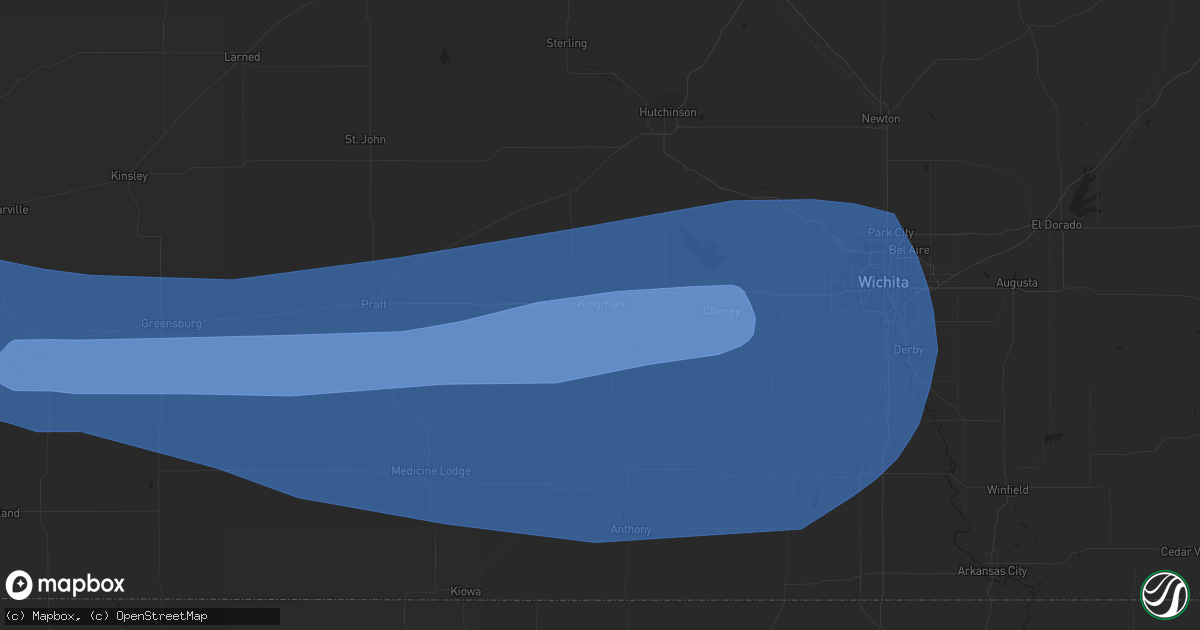
Hail Map in Kingman, KS on June 14, 2019
Get this storm
June 14 map
$229
one time, instant access
Download today. No call, no setup
Keep the $229
Bought the map and want the full workflow? Apply the entire $229 to a subscription within 7 days. None of it is wasted.
Every map, not just this one
This buys you this map. Subscription and you get every map we run, in the markets you choose from a few cities to whole states to nationwide. Plus real-time alerts the moment a storm fires.
Contact data
Name, contact info, occupancy, even credit band for addresses in the footprint. You go from where it hit to who to call.
Become the source they trust
Unlimited branding weather history reports on demand. You already have the documented answer ready for the property owner, and you are the one who showed up with it.
Property data and RoofTrace estimates
Pull up any address you have got, its value and the exact code rules for that jurisdiction, straight from One Click Code. Then RoofTrace estimates the squares, pitch, and roof value, priced the way you price.
Storm reports in Kingman, KS
Kingman, KS
| Date | Description |
|---|---|
| 06/14/201912:25 AM CDT | State trooper reported 70+ mph winds that leveled a shed and destroyed a chicken coop. |
| 06/14/201912:05 AM CDT | At least 75 mph winds estimated 1/4 mile southwest of the airport. |
| 06/14/201912:00 AM CDT | Personal weather station measured 59mph. |
| 06/13/201911:59 PM CDT | Delayed report of several trees and limbs down 1/4 mile southwest of the kingman airport. |
All States Impacted by Hail Map on June 14, 2019
All Cities Impacted by Hail Map on June 14, 2019
- Floydada, TX
- Matador, TX
- Floweree, MT
- Satanta, KS
- Harvard, NE
- Colby, KS
- Valier, MT
- Dutton, MT
- Geyser, MT
- Power, MT
- Brady, MT
- Highwood, MT
- Carter, MT
- Conrad, MT
- Minneapolis, KS
- Shepherd, MT
- Deer Creek, OK
- Medford, OK
- Monument, KS
- Levant, KS
- Plains, KS
- Ong, NE
- Superior, NE
- Hardy, NE
- Winnett, MT
- Newkirk, OK
- Geneva, NE
- McCool Junction, NE
- Pine River, MN
- Richfield, KS
- Guide Rock, NE
- Mott, ND
- New Leipzig, ND
- Lawrence, NE
- Alpine, TX
- Scandia, KS
- Hackensack, MN
- Sublette, KS
- Blue Hill, NE
- Ohiowa, NE
- Cut Bank, MT
- Geraldine, MT
- Henderson, NE
- Aurora, NE
- Braman, OK
- Nardin, OK
- Saronville, NE
- Grafton, NE
- Shickley, NE
- Fairmont, NE
- Sutton, NE
- Roaring Springs, TX
- York, NE
- Granada, CO
- Walsh, CO
- Fort Davis, TX
- Weskan, KS
- Sharon Springs, KS
- Roundup, MT
- Grover, CO
- Manchester, OK
- Terry, MT
- Rush, CO
- Browning, MT
- Kadoka, SD
- Tribune, KS
- Two Buttes, CO
- Lead, SD
- Burlington, OK
- Jet, OK
- Wakita, OK
- New Salem, ND
- Exeter, NE
- Cordova, NE
- Friend, NE
- Courtland, KS
- Republic, KS
- Culbertson, NE
- Fort Stockton, TX
- Calhan, CO
- Yoder, CO
- Hemingford, NE
- Sheridan Lake, CO
- Webber, KS
- Ryder, ND
- Leoti, KS
- Lamont, OK
- Fairchild, WI
- Mankato, KS
- Hebron, ND
- Elkhart, KS
- Moscow, KS
- Grass Range, MT
- North Loup, NE
- Ashton, NE
- Hugo, CO
- Nelson, NE
- Edgar, NE
- Holly, CO
- Angora, NE
- Johnson, KS
- Montezuma, KS
- Waco, NE
- Lamar, CO
- Fort Benton, MT
- Great Falls, MT
- Bridgeport, NE
- Kismet, KS
- Zortman, MT
- Rexford, KS
- Edgemont, SD
- Bison, SD
- Beaver Crossing, NE
- Las Animas, CO
- Syracuse, KS
- Garrison, ND
- Roseglen, ND
- Parshall, ND
- Backus, MN
- Blackwell, OK
- Newell, SD
- Norris, SD
- Red Cloud, NE
- Byers, CO
- Deer Trail, CO
- Utica, NE
- Seward, NE
- Custer, SD
- Ramah, CO
- Valentine, NE
- New Town, ND
- Marathon, TX
- Wellington, CO
- Marmarth, ND
- Rhame, ND
- Ponca City, OK
- Miltonvale, KS
- Clay Center, KS
- Littlefield, TX
- Fieldton, TX
- Olton, TX
- Hale Center, TX
- Goehner, NE
- Davenport, NE
- Belt, MT
- Eau Claire, WI
- Altoona, WI
- Ogema, WI
- Kennan, WI
- Catawba, WI
- Cimarron, KS
- Ingalls, KS
- Holcomb, KS
- Garden City, KS
- Jetmore, KS
- Wallace, KS
- Marienthal, KS
- Scott City, KS
- Winona, KS
- Mulvane, KS
- Spearville, KS
- Protection, KS
- Arlington, KS
- Minneola, KS
- Valley Center, KS
- Freeport, KS
- Attica, KS
- Anthony, KS
- Harper, KS
- Andale, KS
- Caldwell, KS
- Dodge City, KS
- Wichita, KS
- Conway Springs, KS
- Sharon, KS
- Sedgwick, KS
- Wilmore, KS
- Haviland, KS
- Nashville, KS
- Haven, KS
- Bucklin, KS
- Mayfield, KS
- Murdock, KS
- Peck, KS
- Cunningham, KS
- Colwich, KS
- Bluff City, KS
- Wright, KS
- Zenda, KS
- Kingman, KS
- Sun City, KS
- Isabel, KS
- Milan, KS
- Clearwater, KS
- Ford, KS
- Waldron, KS
- Spivey, KS
- Pretty Prairie, KS
- Iuka, KS
- Cheney, KS
- Medicine Lodge, KS
- Viola, KS
- Argonia, KS
- Greensburg, KS
- Norwich, KS
- Garden Plain, KS
- Haysville, KS
- Wellington, KS
- Lake City, KS
- Sawyer, KS
- Hazelton, KS
- Mullinville, KS
- Derby, KS
- Danville, KS
- Coats, KS
- Kechi, KS
- Coldwater, KS
- Milton, KS
- Pratt, KS
- Goddard, KS
- Mount Hope, KS
- Maize, KS
- Mcconnell Afb, KS
- Belle Plaine, KS
- Turon, KS
- Little River, KS
- Hutchinson, KS
- Nickerson, KS
- Inman, KS
- Mcpherson, KS
- Sterling, KS
- Lyons, KS
- Windom, KS
- Buhler, KS


