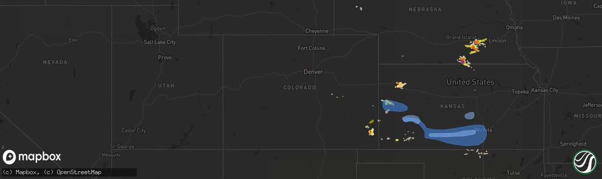
Hail Map in Colorado on June 14, 2019
The weather event in Colorado on June 14, 2019 includes Hail, Wind, and Tornado maps. 10 states and 234 cities were impacted and suffered possible damage. The total estimated number of properties impacted is 102.
Want more than just the map?
Turn this storm into a full workflow.
- Owner + property data so you know who to knock
- OnDemand branded weather history reports to win the "did we even have hail?" argument
- RoofTrace estimate so reps stop guessing numbers at the door
Bought this map? Upgrade within 7 days and we'll credit the $230. (10-15 min setup call)
Hail
Wind
Tornado
102
Estimated number of impacted properties by a 1.00" hail or larger6
Estimated number of impacted properties by a 1.75" hail or larger0
Estimated number of impacted properties by a 2.50" hail or largerStorm reports in Colorado
Colorado
| Date | Description |
|---|---|
| 06/14/20196:41 PM CDT | Asos station kgjt grand junction rgnl ap. |
| 06/14/20195:54 PM CDT | A local report indicates 1.75 inch wind near TWO BUTTES |
| 06/14/20195:30 PM CDT | Winds were atleast 50 mph... Maybe 60 mph. |
| 06/14/20193:55 PM CDT | Mesonet station co098 douglas pass. |
| 06/14/201912:31 AM CDT | At 531 PM MDT, a severe thunderstorm was located 10 miles north of Two Buttes Reservoir, or 19 miles south of Lamar, moving northeast at 20 mph. HAZARD...Ping pong ball size hail and 60 mph wind gusts. SOURCE...Radar indicated. IMPACT...People and animals outdoors will be injured. Expect hail damage to roofs, siding, windows, and vehicles. Expect wind damage to roofs, siding, and trees. This severe thunderstorm will remain over mainly rural areas of southern Prowers County. |
| 06/14/201912:13 AM CDT | At 513 PM MDT, a severe thunderstorm was located 21 miles northwest of Pritchett, or 27 miles northwest of Springfield, moving east at 30 mph. HAZARD...60 mph wind gusts and half dollar size hail. SOURCE...Radar indicated. IMPACT...Hail damage to vehicles is expected. Expect wind damage to roofs, siding, and trees. This severe thunderstorm will remain over mainly rural areas of northwestern Baca, northeastern Las Animas and southeastern Bent Counties. |
| 06/14/201912:01 AM CDT | At 501 PM MDT, a severe thunderstorm was located near Lamar, moving east at 55 mph. HAZARD...60 mph wind gusts and nickel size hail. SOURCE...Radar indicated. IMPACT...Expect damage to roofs, siding, and trees. Locations impacted include... Lamar, Granada, Wiley, Hartman, McClave and Bristol. |
| 06/13/201911:55 PM CDT | At 454 PM MDT/554 PM CDT/, severe thunderstorms were located along a line extending from 8 miles west of Bonny Reservoir to 3 miles southwest of Kanorado to near Weskan to 12 miles north of Towner, moving east at 40 mph. HAZARD...60 mph wind gusts and quarter size hail. SOURCE...Radar indicated. IMPACT...Hail damage to vehicles is expected. Expect wind damage to roofs, siding, and trees. Locations impacted include... Goodland, Leoti, Sharon Springs, Tribune, Brewster, Kanorado and Ruleton.This includes the following highways... Interstate 70 in Kansas between mile markers 0 and 39. Interstate 70 in Colorado between mile markers 445 and 450. Highway 385 between mile markers 200 and 206, and near mile marker211. |
| 06/13/201911:52 PM CDT | At 452 PM MDT, a severe thunderstorm was located near Two Buttes, or 18 miles northeast of Springfield, moving north at 10 mph. HAZARD...Ping pong ball size hail and 60 mph wind gusts. SOURCE...Radar indicated. IMPACT...People and animals outdoors will be injured. Expect hail damage to roofs, siding, windows, and vehicles. Expect wind damage to roofs, siding, and trees. Locations impacted include... Two Buttes and Two Buttes Reservoir. |
| 06/13/201911:33 PM CDT | At 432 PM MDT, a severe thunderstorm was located near Two Buttes, or 16 miles west of The Saunders Elevator, moving northeast at 20 mph. HAZARD...60 mph wind gusts and quarter size hail. SOURCE...Radar indicated. IMPACT...Hail damage to vehicles is expected. Expect wind damage to roofs, siding, and trees. Locations impacted include... Two Buttes. |
| 06/13/20198:17 PM CDT | At 117 PM MDT, a severe thunderstorm was located near Yoder, or 33 miles east of Colorado Springs, moving east at 45 mph. HAZARD...60 mph wind gusts and quarter size hail. SOURCE...Radar indicated. IMPACT...Hail damage to vehicles is expected. Expect wind damage to roofs, siding, and trees. This severe thunderstorm will remain over mainly rural areas of east central El Paso County. |
All States Impacted by Hail Map on June 14, 2019
Cities Impacted by Hail Map on June 14, 2019
- Floydada, TX
- Matador, TX
- Floweree, MT
- Satanta, KS
- Harvard, NE
- Colby, KS
- Valier, MT
- Dutton, MT
- Geyser, MT
- Power, MT
- Brady, MT
- Highwood, MT
- Carter, MT
- Conrad, MT
- Minneapolis, KS
- Shepherd, MT
- Deer Creek, OK
- Medford, OK
- Monument, KS
- Levant, KS
- Plains, KS
- Ong, NE
- Superior, NE
- Hardy, NE
- Winnett, MT
- Newkirk, OK
- Geneva, NE
- McCool Junction, NE
- Pine River, MN
- Richfield, KS
- Guide Rock, NE
- Mott, ND
- New Leipzig, ND
- Lawrence, NE
- Alpine, TX
- Scandia, KS
- Hackensack, MN
- Sublette, KS
- Blue Hill, NE
- Ohiowa, NE
- Cut Bank, MT
- Geraldine, MT
- Henderson, NE
- Aurora, NE
- Braman, OK
- Nardin, OK
- Saronville, NE
- Grafton, NE
- Shickley, NE
- Fairmont, NE
- Sutton, NE
- Roaring Springs, TX
- York, NE
- Granada, CO
- Walsh, CO
- Fort Davis, TX
- Weskan, KS
- Sharon Springs, KS
- Roundup, MT
- Grover, CO
- Manchester, OK
- Terry, MT
- Rush, CO
- Browning, MT
- Kadoka, SD
- Tribune, KS
- Two Buttes, CO
- Lead, SD
- Burlington, OK
- Jet, OK
- Wakita, OK
- New Salem, ND
- Exeter, NE
- Cordova, NE
- Friend, NE
- Courtland, KS
- Republic, KS
- Culbertson, NE
- Fort Stockton, TX
- Calhan, CO
- Yoder, CO
- Hemingford, NE
- Sheridan Lake, CO
- Webber, KS
- Ryder, ND
- Leoti, KS
- Lamont, OK
- Fairchild, WI
- Mankato, KS
- Hebron, ND
- Elkhart, KS
- Moscow, KS
- Grass Range, MT
- North Loup, NE
- Ashton, NE
- Hugo, CO
- Nelson, NE
- Edgar, NE
- Holly, CO
- Angora, NE
- Johnson, KS
- Montezuma, KS
- Waco, NE
- Lamar, CO
- Fort Benton, MT
- Great Falls, MT
- Bridgeport, NE
- Kismet, KS
- Zortman, MT
- Rexford, KS
- Edgemont, SD
- Bison, SD
- Beaver Crossing, NE
- Las Animas, CO
- Syracuse, KS
- Garrison, ND
- Roseglen, ND
- Parshall, ND
- Backus, MN
- Blackwell, OK
- Newell, SD
- Norris, SD
- Red Cloud, NE
- Byers, CO
- Deer Trail, CO
- Utica, NE
- Seward, NE
- Custer, SD
- Ramah, CO
- Valentine, NE
- New Town, ND
- Marathon, TX
- Wellington, CO
- Marmarth, ND
- Rhame, ND
- Ponca City, OK
- Miltonvale, KS
- Clay Center, KS
- Littlefield, TX
- Fieldton, TX
- Olton, TX
- Hale Center, TX
- Goehner, NE
- Davenport, NE
- Belt, MT
- Eau Claire, WI
- Altoona, WI
- Ogema, WI
- Kennan, WI
- Catawba, WI
- Cimarron, KS
- Ingalls, KS
- Holcomb, KS
- Garden City, KS
- Jetmore, KS
- Wallace, KS
- Marienthal, KS
- Scott City, KS
- Winona, KS
- Mulvane, KS
- Spearville, KS
- Protection, KS
- Arlington, KS
- Minneola, KS
- Valley Center, KS
- Freeport, KS
- Attica, KS
- Anthony, KS
- Harper, KS
- Andale, KS
- Caldwell, KS
- Dodge City, KS
- Wichita, KS
- Conway Springs, KS
- Sharon, KS
- Sedgwick, KS
- Wilmore, KS
- Haviland, KS
- Nashville, KS
- Haven, KS
- Bucklin, KS
- Mayfield, KS
- Murdock, KS
- Peck, KS
- Cunningham, KS
- Colwich, KS
- Bluff City, KS
- Wright, KS
- Zenda, KS
- Kingman, KS
- Sun City, KS
- Isabel, KS
- Milan, KS
- Clearwater, KS
- Ford, KS
- Waldron, KS
- Spivey, KS
- Pretty Prairie, KS
- Iuka, KS
- Cheney, KS
- Medicine Lodge, KS
- Viola, KS
- Argonia, KS
- Greensburg, KS
- Norwich, KS
- Garden Plain, KS
- Haysville, KS
- Wellington, KS
- Lake City, KS
- Sawyer, KS
- Hazelton, KS
- Mullinville, KS
- Derby, KS
- Danville, KS
- Coats, KS
- Kechi, KS
- Coldwater, KS
- Milton, KS
- Pratt, KS
- Goddard, KS
- Mount Hope, KS
- Maize, KS
- Mcconnell Afb, KS
- Belle Plaine, KS
- Turon, KS
- Little River, KS
- Hutchinson, KS
- Nickerson, KS
- Inman, KS
- Mcpherson, KS
- Sterling, KS
- Lyons, KS
- Windom, KS
- Buhler, KS


