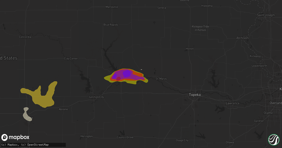
Hail Map in Wamego, KS on June 13, 2024
Get this storm
June 13 map
$229
one time, instant access
Download today. No call, no setup
Keep the $229
Bought the map and want the full workflow? Apply the entire $229 to a subscription within 7 days. None of it is wasted.
Every map, not just this one
This buys you this map. Subscription and you get every map we run, in the markets you choose from a few cities to whole states to nationwide. Plus real-time alerts the moment a storm fires.
Contact data
Name, contact info, occupancy, even credit band for addresses in the footprint. You go from where it hit to who to call.
Become the source they trust
Unlimited branding weather history reports on demand. You already have the documented answer ready for the property owner, and you are the one who showed up with it.
Property data and RoofTrace estimates
Pull up any address you have got, its value and the exact code rules for that jurisdiction, straight from One Click Code. Then RoofTrace estimates the squares, pitch, and roof value, priced the way you price.
Storm reports in Wamego, KS
Wamego, KS
| Date | Description |
|---|---|
| 06/12/20247:53 PM CDT | Report from mping: ping pong ball |
| 06/12/20247:52 PM CDT | A local report indicates 1.50 inch wind near Wamego |
| 06/12/20247:50 PM CDT | Social media report. Time estimated from radar. |
| 06/12/20247:50 PM CDT | Delayed report from wamego. Social media. |
| 06/12/20247:46 PM CDT | A local report indicates 1.75 inch wind near Louisville |
| 06/12/20247:46 PM CDT | A local report indicates 1.75 inch wind near Wamego |
| 06/12/20247:46 PM CDT | Corrects previous hail report from wamego. |
| 06/12/20247:45 PM CDT | Report from mping: hen egg |
| 06/12/20247:41 PM CDT | Report from mping: half dollar |
| 06/12/20247:39 PM CDT | A local report indicates 1.75 inch wind near 3 W Wamego |
| 06/12/20247:38 PM CDT | A local report indicates 1.25 inch wind near 2 ENE Saint George |
All States Impacted by Hail Map on June 13, 2024
All Cities Impacted by Hail Map on June 13, 2024
- Hays, KS
- Ellis, KS
- Brownell, KS
- South Elgin, IL
- Saint Charles, IL
- Elgin, IL
- Wayne, IL
- Bartlett, IL
- Hanover Park, IL
- Carol Stream, IL
- West Chicago, IL
- Marquette, MI
- Negaunee, MI
- Skandia, MI
- Deerton, MI
- Eben Junction, MI
- Chatham, MI
- Trenary, MI
- Rumely, MI
- Munising, MI
- Wetmore, MI
- Seney, MI
- Manistique, MI
- McMillan, MI
- Newberry, MI
- Germfask, MI
- Rapid River, MI
- Gulliver, MI
- Panama City, FL
- Eckerman, MI
- Mims, FL
- Kinross, MI
- Brimley, MI
- Vona, CO
- Cincinnati, IA
- Centerville, IA
- Exline, IA
- Seymour, IA
- Stratton, CO
- Moulton, IA
- Unionville, MO
- Coatsville, MO
- Livonia, MO
- Glenwood, MO
- Queen City, MO
- Lancaster, MO
- Leoti, KS
- Bloomfield, IA
- Ottumwa, IA
- Eldon, IA
- Manteno, IL
- Floris, IA
- Green Castle, MO
- Novinger, MO
- Downing, MO
- Selma, IA
- Batavia, IA
- Libertyville, IA
- Fairfield, IA
- Douds, IA
- Grant Park, IL
- Momence, IL
- Arapahoe, CO
- Memphis, MO
- Greentop, MO
- Baring, MO
- Kirksville, MO
- Lake Village, IN
- Lowell, IN
- Schneider, IN
- Beecher, IL
- Sharon Springs, KS
- Rutledge, MO
- Edina, MO
- Wallace, KS
- Cantril, IA
- Birmingham, IA
- Keosauqua, IA
- Milton, IA
- Brashear, MO
- Russell, KS
- Scott City, KS
- Pulaski, IA
- Oakley, KS
- Hurdland, MO
- Mishawaka, IN
- South Bend, IN
- Granger, IN
- Elkhart, IN
- Osceola, IN
- Bristol, IN
- Middlebury, IN
- Goshen, IN
- Bonaparte, IA
- Bison, KS
- Otis, KS
- Hoisington, KS
- Mount Sterling, IA
- Demotte, IN
- Fair Oaks, IN
- Knox City, MO
- Arbela, MO
- Farmington, IA
- Luray, MO
- Kahoka, MO
- Olmitz, KS
- Stockport, IA
- Hillsboro, IA
- Garden City, KS
- Hebron, IN
- Dorrance, KS
- Bunker Hill, KS
- Donnellson, IA
- Lockridge, IA
- La Belle, MO
- Wayland, MO
- Revere, MO
- Ewing, MO
- Lewistown, MO
- Wheatfield, IN
- Winona, KS
- Beverly, KS
- Monticello, MO
- Maywood, MO
- Durham, MO
- Argyle, IA
- Montrose, IA
- Keokuk, IA
- Nauvoo, IL
- Hamilton, IL
- Warsaw, IL
- Basco, IL
- Alexandria, MO
- Carthage, IL
- Elvaston, IL
- Lincoln, KS
- Green City, MO
- Rensselaer, IN
- Mount Pleasant, IA
- Newark, MO
- Wilson, KS
- La Grange, MO
- Rush Center, KS
- Solomon, KS
- Minneapolis, KS
- Bennington, KS
- Ulysses, KS
- Limon, CO
- La Crosse, KS
- Mount Union, IA
- Carman, IL
- West Burlington, IA
- Burlington, IA
- Wyaconda, MO
- Gorin, MO
- Clay Center, KS
- Longford, KS
- New London, IA
- Albert, KS
- Nekoma, KS
- Alexander, KS
- Great Bend, KS
- Sublette, KS
- Ness City, KS
- Wakefield, KS
- Brookville, KS
- New Cambria, KS
- Salina, KS
- Ellsworth, KS
- Genoa, CO
- Burdett, KS
- Cimarron, KS
- Jetmore, KS
- Ingalls, KS
- Wright, KS
- Dodge City, KS
- Ensign, KS
- Abilene, KS
- Rozel, KS
- Larned, KS
- Milford, KS
- Hanston, KS
- West Point, IA
- Morning Sun, IA
- Yarmouth, IA
- Saint Patrick, MO
- Ellinwood, KS
- Hudson, KS
- Riley, KS
- Danville, IA
- Lindon, CO
- Middletown, IA
- Gladstone, IL
- Bronson, MI
- Winfield, IA
- Canton, MO
- Good Hope, IL
- Bushnell, IL
- Garfield, KS
- Kinsley, KS
- St John, KS
- Pawnee Rock, KS
- Milan, MO
- Gibbs, MO
- Offerle, KS
- Sperry, IA
- Mediapolis, IA
- Manhattan, KS
- La Plata, MO
- Nara Visa, NM
- Ford, KS
- Bucklin, KS
- Spearville, KS
- Minneola, KS
- Mullinville, KS
- Quincy, IL
- Ursa, IL
- Sylvia, KS
- Oakville, IA
- Wapello, IA
- Saint George, KS
- Wamego, KS
- Gypsum, KS
- Greensburg, KS
- Meade, KS
- Ransom, KS
- Utica, KS
- Clayton, IL
- Fowler, IL
- Liberty, IL
- Camp Point, IL
- Sylvan Grove, KS
- Yerington, NV
- Fowler, KS
- Prairie City, IL
- Lewis, KS
- Williamstown, MO
- Englewood, KS
- Ashland, KS
- Haviland, KS
- Sun City, KS
- Wilmore, KS
- Coldwater, KS
- Protection, KS
- Stronghurst, IL
- Novelty, MO
- Tampa, KS
- Wakeeney, KS
- New Boston, MO
- Winigan, MO
- Browning, MO
- Timewell, IL
- Mount Sterling, IL
- Elmer, MO
- Versailles, IL
- Brookfield, MO
- Belvue, KS
- Durham, KS
- Ainsworth, IA
- Ethel, MO
- Onaga, KS
- Strong City, KS
- Elmdale, KS
- Cuba, IL
- Francesville, IN
- Keithsburg, IL
- Seaton, IL
- Blandinsville, IL
- Sciota, IL
- Washington, IA
- Crawfordsville, IA
- Paxico, KS
- Cottonwood Falls, KS
- Rosston, OK
- Buffalo, OK
- Havensville, KS
- Soldier, KS
- Delia, KS
- Emmett, KS
- Avon, IL
- Smithfield, IL
- Aledo, IL
- Viola, IL
- Alexis, IL
- Macomb, IL
- Liberal, KS
- Arenzville, IL
- Beardstown, IL
- Adrian, TX
- Saint Marys, KS
- Fort Madison, IA
- Plevna, KS
- Turon, KS
- Salem, IA
- New Cambria, MO
- Bucklin, MO
- Atlanta, MO
- Leonard, MO
- Shelbyville, MO
- Bethel, MO
- Stafford, KS
- Holton, KS
- Mayetta, KS
- Lucas, KS
- Amarillo, TX
- Marietta, IL
- Forgan, OK
- Callao, MO
- Linneus, MO
- Bevier, MO
- Purdin, MO
- Columbus Junction, IA
- Lyndon, KS
- Lenexa, KS
- Richmond, MO
- Quenemo, KS
- Hale, MO
- Eudora, KS
- Dumas, TX
- Olathe, KS
- Norborne, MO
- Kansas City, MO
- Reading, KS
- Shawnee, KS
- Burns, KS
- Osage City, KS
- Independence, MO
- Perryton, TX
- Emporia, KS
- Newton, KS
- Mission, KS
- Laverne, OK
- Vassar, KS
- Lake City, KS
- Mount Hope, KS
- Spivey, KS
- Spearman, TX
- Sibley, MO
- Sedgwick, KS
- Balko, OK
- De Soto, KS
- Colwich, KS
- Cheney, KS
- Murdock, KS
- Isabel, KS
- Kingman, KS
- Overbrook, KS
- Kansas City, KS
- Channing, TX
- Baldwin City, KS
- Huntsville, MO
- New Windsor, IL
- North Henderson, IL
- Ludlow, MO
- Kingston, MO
- Hillsboro, KS
- Lehigh, KS
- Denison, KS
- Marceline, MO
- Macon, MO
- Winchester, IL
- Monmouth, IL
- Arlington, KS
- Pekin, IL
- Hunnewell, MO
- Shelbina, MO
- Emden, MO
- Freedom, OK
- Valley Falls, KS
- Hoyt, KS
- Jacksonville, IL
- Alexander, IL
- Dawn, MO
- Breckenridge, MO
- Braymer, MO
- Bogard, MO
- Carrollton, MO
- Higbee, MO
- Moberly, MO
- Clifton Hill, MO
- Tremont, IL
- Clark, MO
- Galesburg, IL
- Gerlaw, IL
- Rio, IL
- Monticello, IN
- Buffalo, IN
- Winamac, IN
- Wheeling, MO
- Chula, MO
- Paris, MO
- Salisbury, MO
- Laclede, MO
- East Peoria, IL
- Rothville, MO
- Beaver, OK
- Galva, IL
- Altona, IL
- Alpha, IL
- Oneida, IL
- Woodhull, IL
- Litchfield, IL
- Raymond, IL
- Groveland, IL
- Monroe City, MO
- Stoutsville, MO
- Crown Point, IN
- Meadville, MO
- Sturgeon, MO
- Centralia, MO
- Hallsville, MO
- Gower, MO
- Agency, MO
- New Berlin, IL
- Springfield, IL
- Dahinda, IL
- Williamsfield, IL
- Deer Creek, IL
- Morton, IL
- Fowler, IN
- Speer, IL
- Princeville, IL
- Edelstein, IL
- Chillicothe, IL
- Edgerton, MO
- Gilson, IL
- Minonk, IL
- Dearborn, MO
- Cowgill, MO
- Hardin, MO
- Trimble, MO
- Victoria, IL
- Mackinaw, IL
- Toulon, IL
- Mulvane, KS
- Wataga, IL
- Henderson, IL
- Chillicothe, MO
- Sumner, MO
- Knoxville, IL
- Utica, MO
- El Paso, IL
- Flanagan, IL
- Dunlap, IL
- Camden Point, MO
- Smithville, MO
- Excello, MO
- Mendon, MO
- Perry, MO
- Bradford, IL
- Follett, TX
- Rushville, MO
- De Kalb, MO
- Faucett, MO
- Carlock, IL
- Cairo, MO
- Triplett, MO
- Pembroke Township, IL
- Belle Plaine, KS
- Lexington, MO
- Baileyville, KS
- Mazon, IL
- Gardner, IL
- Platte City, MO
- Wyoming, IL
- Sparland, IL
- Boswell, IN
- Shattuck, OK
- Darrouzett, TX
- Higgins, TX
- Lipscomb, TX
- Arnett, OK
- Higginsville, MO
- Braceville, IL
- Dover, MO
- Udall, KS
- Wilmington, IL
- Essex, IL
- Braidwood, IL
- Bonfield, IL
- Gridley, IL
- Derby, KS
- Haysville, KS
- Peck, KS
- Lexington, IL
- Colfax, IL
- Liberty, MO
- Loveland, CO
- Winfield, KS
- Mayview, MO
- Centralia, KS
- Drake, CO
- De Witt, MO
- Corder, MO
- Bosworth, MO
- Brunswick, MO
- Kankakee, IL
- Bradley, IL
- Bourbonnais, IL
- Keytesville, MO
- Goodfield, IL
- Congerville, IL
- Seneca, KS
- Axtell, KS
- Dexter, KS
- Trenton, MO
- Lyons, CO
- Chatsworth, IL
- Columbia, MO
- Cameron, MO
- Benson, IL
- Cedar Vale, KS
- Clarksdale, MO
- Roseville, IL
- Cedar Lake, IN
- Hiawatha, KS
- Anchor, IL
- Plattsburg, MO
- Paxton, IL
- Melvin, IL
- Gibson City, IL
- Buckner, MO
- Streator, IL
- Concordia, MO
- Ambia, IN
- Ransom, IL
- New Franklin, MO
- Rocheport, MO
- Bates City, MO
- Holden, MO
- Odessa, MO
- Sabetha, KS
- Williamsport, IN
- Hoopeston, IL
- Miami, MO
- Oak Grove, MO
- Napoleon, MO
- Polo, MO
- Saint Joseph, MO
- Easton, MO
- Oneida, KS
- Fulton, MO
- Auxvasse, MO
- Kingdom City, MO
- Lawson, MO
- Rayville, MO
- Morris, IL
- Verona, IL
- Canadian, TX
- Bern, KS
- Dwight, IL
- Kinsman, IL
- Glasgow, MO
- Waverly, MO
- Centerview, MO
- Marshall, MO
- Morrill, KS
- Edwards, MO
- Stover, MO
- Climax Springs, MO
- Clinton, MO
- Oregon, MO
- Troy, KS
- Urich, MO
- Montrose, MO
- Missouri City, MO
- Henrietta, MO
- Boonville, MO
- Roach, MO
- Gravois Mills, MO
- White Cloud, KS
- Canton, IL
- Holt, MO
- Kearney, MO
- Macks Creek, MO
- Coldwater, MI
- Brooksville, FL
- Arkansas City, KS
- Pine Village, IN
- Lathrop, MO
- Grain Valley, MO
- Hughesville, MO
- Sedalia, MO
- Wathena, KS
- Whiteman Air Force Base, MO
- La Monte, MO
- Knob Noster, MO
- Green Ridge, MO
- Windsor, MO
- Warrensburg, MO
- Robinson, KS
- Leeton, MO
- Kingsville, MO
- Green Valley, IL
- Lincoln, MO
- Versailles, MO
- Bluffs, IL
- Cole Camp, MO
- Wellington, MO
- Calhoun, MO
- Monon, IN
- Delavan, IL
- Tina, MO
- Camdenton, MO
- Preston, MO
- Quincy, MO
- Warsaw, MO
- La Fayette, IL
- Osceola, MO
- Cross Timbers, MO
- Laura, IL
- Attica, IN
- Walnut Grove, MO
- Secor, IL
- Ash Grove, MO
- Willard, MO
- Clarksburg, MO
- Fortuna, MO
- Pleasant Plains, IL
- Springfield, MO
- Hudson, IL
- Sheffield, IL
- Wyanet, IL
- Manlius, IL
- Princeton, IL
- Bois D Arc, MO
- Rossville, IL
- Saint Anne, IL
- Buffalo, MO
- Tipton, MO
- Latham, MO
- California, MO
- Peotone, IL
- Mora, MO
- Smithton, MO
- Sweet Springs, MO
- Republic, MO
- Brookline, MO
- Nixa, MO
- Aurora, MO
- Billings, MO
- Marionville, MO
- Ionia, MO
- Clever, MO
- Ozark, MO
- Verona, MO
- Logansport, IN
- Crane, MO
- Wenona, IL
- Saint David, IL
- Galena, MO
- Eureka, IL
- Danvers, IL
- Roanoke, IL
- Reddick, IL
- Coal City, IL
- Chenoa, IL
- Coatsburg, IL
- Champaign, IL
- Urbana, IL
- Minier, IL
- Atlanta, IL
- Lincoln, IL
- Crawfordsville, IN
- Nunn, CO
- Niota, IL


