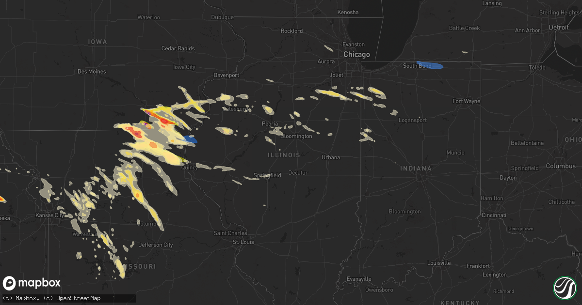
Hail Map in Illinois on June 13, 2024
Get this storm
June 13 map
$229
one time, instant access
Download today. No call, no setup
Keep the $229
Bought the map and want the full workflow? Apply the entire $229 to a subscription within 7 days. None of it is wasted.
Every map, not just this one
This buys you this map. Subscription and you get every map we run, in the markets you choose from a few cities to whole states to nationwide. Plus real-time alerts the moment a storm fires.
Contact data
Name, contact info, occupancy, even credit band for addresses in the footprint. You go from where it hit to who to call.
Become the source they trust
Unlimited branding weather history reports on demand. You already have the documented answer ready for the property owner, and you are the one who showed up with it.
Property data and RoofTrace estimates
Pull up any address you have got, its value and the exact code rules for that jurisdiction, straight from One Click Code. Then RoofTrace estimates the squares, pitch, and roof value, priced the way you price.
Storm reports in Illinois
Illinois
| Date | Description |
|---|---|
| 06/13/20246:56 PM CDT | Power pole knocked down from thunderstorm winds. Time estimated from radar. |
| 06/13/20246:56 PM CDT | A brief tornado touchdown was observed by a chaser northeast of the macomb municipal airport. This tornado occurred in an open field and no damage was observed. Therefo |
| 06/13/20246:53 PM CDT | Sheriff office reported serval structures damaged... Powerline down. |
| 06/13/20246:51 PM CDT | Ethan schisler trained spotter. Tornado on ground. |
| 06/13/20246:41 PM CDT | Relayed from ilx: trained spotter reported quarter sized hail near hersman on rte 99. |
| 06/13/20246:40 PM CDT | Small limbs down and some large branches snapped from trees. |
| 06/13/20246:30 PM CDT | Picture of a large branch broken off of a hickory tree. |
| 06/13/20246:02 PM CDT | Multiple large trees down near 24th street and boy scout road. Some roof damage to some farm outbuildings as well. |
| 06/13/20246:01 PM CDT | Trained spotter reported 60 mph winds at boy scout road and north hwy 24... North quincy. |
| 06/13/20246:01 PM CDT | Via slack. Large trees snapped near base and power pole snapped on north side of quincy near hwy 96 and hwy 24. |
| 06/13/20246:00 PM CDT | Adams county em reported farm structures down and trees uprooted near hwy 96 and hwy 24. |
| 06/13/20246:00 PM CDT | Corrects previous tstm wnd dmg report from 4 s ursa. Via twitter with photo. Snapped power pole with lines lying in street. Highway 96 at highway 24. Emergency manager |
| 06/13/20246:00 PM CDT | Corrects previous tstm wnd dmg report from 4 s ursa. Via twitt |
| 06/13/20246:00 PM CDT | Via twitter with photo. Snapped power pole with lines lying in street. Highway 96 at highway 24. |
| 06/13/20247:58 AM CDT | Trained weather spotter measured a peak gust of 70 mph. Patio furniture was damaged during the thunderstorm. Time estimated by radar. |
| 06/13/20247:55 AM CDT | Tree limbs around 6 inches in diameter were downed... And a fence was damaged. Time estimated by radar. |
| 06/13/202412:08 AM CDT | Irrigation pivot overturned and large trees broken. Time estimated from radar. |
| 06/12/202410:10 PM CDT | Time estimated from radar. |
| 06/12/20249:53 PM CDT | Report from mping: 1-inch tree limbs broken; shingles blown off. |
| 06/12/20249:45 PM CDT | Tree fell on a house... Causing damage to the roof. Time estimated from radar. |
| 06/12/20249:30 PM CDT | Large tree broken. Chimney blown off a farmhouse. Time estimated from radar. |
| 06/12/20249:25 PM CDT | Two 50 foot trees snapped. Time estimated from radar. |
| 06/12/20249:20 PM CDT | Power pole down on county road 2200n between 1000e and 1100e. Time estimated from radar. |
| 06/12/20249:20 PM CDT | Large tree branch down. Time estimated from radar. |
| 06/12/20249:18 PM CDT | Trees down in paxton... At least one large one with a snapped trunk. |
| 06/12/20249:18 PM CDT | Two cars crushed by falling trees near the intersection of maple and center. |
| 06/12/20249:15 PM CDT | Trees down. Time estimated from radar. |
| 06/12/20249:11 PM CDT | Large trees down and power poles down. Time estimated from radar. |
| 06/12/20249:10 PM CDT | Tree blown down. Time estimated from radar. |
| 06/12/20249:08 PM CDT | Barn door blown off along route 47 north of town. Large tree branch broken off. Time estimated from radar. |
| 06/12/20249:05 PM CDT | Numerous power lines/poles downed near melvin. Time estimated from radar. |
| 06/12/20249:00 PM CDT | Tree down on powerlines. Time estimated from radar. |
| 06/12/20248:59 PM CDT | Trees were downed onto state routes 47 and 54 south/southwest of gibson city. Time estimated from radar. |
| 06/12/20248:59 PM CDT | Updates previous tstm wnd dmg report from gibson city. Widespread wind damage across gibson city. Numerous trees and power lines downed with some trees snapped at their |
| 06/12/20248:59 PM CDT | Trees downed in sibley... Including one onto a house. Time estimated from radar. |
| 06/12/20248:59 PM CDT | Reports of widespread wind damage incl |
| 06/12/20248:59 PM CDT | Reports of widespread wind damage including downed trees and powerlines in gibson city. Time estimated based on radar. |
| 06/12/20248:58 PM CDT | Photos were sent in of a wooden shed whose side and roof were ripped off and strewn across the yard. In addition... A childrens playset was blown over... The top shed o |
| 06/12/20248:58 PM CDT | Tree down on power lines. Shed blown across road. Time estimated from radar. |
| 06/12/20248:57 PM CDT | Measured with an ambient weather station. |
| 06/12/20248:50 PM CDT | Trees and powerlines down. Time estimated from radar. |
| 06/12/20248:45 PM CDT | Numerous trees damaged... With one large tree down. Time estimated by radar. |
| 06/12/20248:45 PM CDT | Numerous trees down. Time estimated. |
| 06/12/20248:44 PM CDT | (ilx |
| 06/12/20248:44 PM CDT | A local report indicates 60 MPH wind near Anchor |
| 06/12/20248:40 PM CDT | 911 dispatch reported power lines down and damage to trees. |
| 06/12/20248:40 PM CDT | A local report indicates 65 MPH wind near 2 SSW Deer Creek |
| 06/12/20248:40 PM CDT | Shingle and siding damage to a house. Time estimated by radar. |
| 06/12/20248:40 PM CDT | Tree down across route 9 near the cooksville-ellsworth blacktop. |
| 06/12/20248:39 PM CDT | Personal weather station kilcooks5. |
| 06/12/20248:36 PM CDT | A personal weather station measured a 71 mph wind gust 2 miles south of weston. |
| 06/12/20248:35 PM CDT | Corrects previous tstm wnd dmg report from pontiac. 911 dispatch reported power lines down... Damage to trees... As well as a street lamp that was knocked over. |
| 06/12/20248:35 PM CDT | Large whole trees down on power lines. |
| 06/12/20248:33 PM CDT | Numerous large tree limbs down. |
| 06/12/20248:30 PM CDT | Corrects previous non-tstm wnd dmg report from streator. 911 dispatch reported power lines down and damage to trees. |
| 06/12/20248:30 PM CDT | A local report indicates 60 MPH wind near Washington |
| 06/12/20248:30 PM CDT | Semi trailer turned over on interstate 55 just south of chenoa. |
| 06/12/20248:25 PM CDT | Tree down on home. |
| 06/12/20248:25 PM CDT | Downed power lines north lexington. |
| 06/12/20248:20 PM CDT | A local report indicates 60 MPH wind near 3 WNW Benson |
| 06/12/20248:20 PM CDT | A local report indicates 60 MPH wind near 3 S Minonk |
| 06/12/20248:05 PM CDT | House fire due to power lines down. |
| 06/12/20248:05 PM CDT | 3 inch tree limbs down. |
| 06/12/20248:03 PM CDT | Delayed report. Time estimated by radar. Large carport torn away and wrapped around utility pole. |
| 06/12/20247:56 PM CDT | Power line down south of curran. |
| 06/12/20247:43 PM CDT | Power line down near interchange of e muller rd and springfield rd. |
| 06/12/20247:08 PM CDT | Delayed report... Several large tree branches over hwy 17 blocking the road. Time estimated from radar. |
| 06/12/20247:08 PM CDT | Report from mping: 1-inch tree limbs broken; shingles blown off. |
| 06/12/20247:03 PM CDT | Ethan schisler tornado on ground 3.7 miles sw bushnell il. |
| 06/12/20247:01 PM CDT | A brief tornado was observed in an open field between bushnell and bardolph. There was no observed damage with the tornado... And therefore has been assigned an ef-unkn |
All States Impacted by Hail Map on June 13, 2024
Cities Impacted by Hail Map on June 13, 2024
- Hays, KS
- Ellis, KS
- Brownell, KS
- South Elgin, IL
- Saint Charles, IL
- Elgin, IL
- Wayne, IL
- Bartlett, IL
- Hanover Park, IL
- Carol Stream, IL
- West Chicago, IL
- Marquette, MI
- Negaunee, MI
- Skandia, MI
- Deerton, MI
- Eben Junction, MI
- Chatham, MI
- Trenary, MI
- Rumely, MI
- Munising, MI
- Wetmore, MI
- Seney, MI
- Manistique, MI
- McMillan, MI
- Newberry, MI
- Germfask, MI
- Rapid River, MI
- Gulliver, MI
- Panama City, FL
- Eckerman, MI
- Mims, FL
- Kinross, MI
- Brimley, MI
- Vona, CO
- Cincinnati, IA
- Centerville, IA
- Exline, IA
- Seymour, IA
- Stratton, CO
- Moulton, IA
- Unionville, MO
- Coatsville, MO
- Livonia, MO
- Glenwood, MO
- Queen City, MO
- Lancaster, MO
- Leoti, KS
- Bloomfield, IA
- Ottumwa, IA
- Eldon, IA
- Manteno, IL
- Floris, IA
- Green Castle, MO
- Novinger, MO
- Downing, MO
- Selma, IA
- Batavia, IA
- Libertyville, IA
- Fairfield, IA
- Douds, IA
- Grant Park, IL
- Momence, IL
- Arapahoe, CO
- Memphis, MO
- Greentop, MO
- Baring, MO
- Kirksville, MO
- Lake Village, IN
- Lowell, IN
- Schneider, IN
- Beecher, IL
- Sharon Springs, KS
- Rutledge, MO
- Edina, MO
- Wallace, KS
- Cantril, IA
- Birmingham, IA
- Keosauqua, IA
- Milton, IA
- Brashear, MO
- Russell, KS
- Scott City, KS
- Pulaski, IA
- Oakley, KS
- Hurdland, MO
- Mishawaka, IN
- South Bend, IN
- Granger, IN
- Elkhart, IN
- Osceola, IN
- Bristol, IN
- Middlebury, IN
- Goshen, IN
- Bonaparte, IA
- Bison, KS
- Otis, KS
- Hoisington, KS
- Mount Sterling, IA
- Demotte, IN
- Fair Oaks, IN
- Knox City, MO
- Arbela, MO
- Farmington, IA
- Luray, MO
- Kahoka, MO
- Olmitz, KS
- Stockport, IA
- Hillsboro, IA
- Garden City, KS
- Hebron, IN
- Dorrance, KS
- Bunker Hill, KS
- Donnellson, IA
- Lockridge, IA
- La Belle, MO
- Wayland, MO
- Revere, MO
- Ewing, MO
- Lewistown, MO
- Wheatfield, IN
- Winona, KS
- Beverly, KS
- Monticello, MO
- Maywood, MO
- Durham, MO
- Argyle, IA
- Montrose, IA
- Keokuk, IA
- Nauvoo, IL
- Hamilton, IL
- Warsaw, IL
- Basco, IL
- Alexandria, MO
- Carthage, IL
- Elvaston, IL
- Lincoln, KS
- Green City, MO
- Rensselaer, IN
- Mount Pleasant, IA
- Newark, MO
- Wilson, KS
- La Grange, MO
- Rush Center, KS
- Solomon, KS
- Minneapolis, KS
- Bennington, KS
- Ulysses, KS
- Limon, CO
- La Crosse, KS
- Mount Union, IA
- Carman, IL
- West Burlington, IA
- Burlington, IA
- Wyaconda, MO
- Gorin, MO
- Clay Center, KS
- Longford, KS
- New London, IA
- Albert, KS
- Nekoma, KS
- Alexander, KS
- Great Bend, KS
- Sublette, KS
- Ness City, KS
- Wakefield, KS
- Brookville, KS
- New Cambria, KS
- Salina, KS
- Ellsworth, KS
- Genoa, CO
- Burdett, KS
- Cimarron, KS
- Jetmore, KS
- Ingalls, KS
- Wright, KS
- Dodge City, KS
- Ensign, KS
- Abilene, KS
- Rozel, KS
- Larned, KS
- Milford, KS
- Hanston, KS
- West Point, IA
- Morning Sun, IA
- Yarmouth, IA
- Saint Patrick, MO
- Ellinwood, KS
- Hudson, KS
- Riley, KS
- Danville, IA
- Lindon, CO
- Middletown, IA
- Gladstone, IL
- Bronson, MI
- Winfield, IA
- Canton, MO
- Good Hope, IL
- Bushnell, IL
- Garfield, KS
- Kinsley, KS
- St John, KS
- Pawnee Rock, KS
- Milan, MO
- Gibbs, MO
- Offerle, KS
- Sperry, IA
- Mediapolis, IA
- Manhattan, KS
- La Plata, MO
- Nara Visa, NM
- Ford, KS
- Bucklin, KS
- Spearville, KS
- Minneola, KS
- Mullinville, KS
- Quincy, IL
- Ursa, IL
- Sylvia, KS
- Oakville, IA
- Wapello, IA
- Saint George, KS
- Wamego, KS
- Gypsum, KS
- Greensburg, KS
- Meade, KS
- Ransom, KS
- Utica, KS
- Clayton, IL
- Fowler, IL
- Liberty, IL
- Camp Point, IL
- Sylvan Grove, KS
- Yerington, NV
- Fowler, KS
- Prairie City, IL
- Lewis, KS
- Williamstown, MO
- Englewood, KS
- Ashland, KS
- Haviland, KS
- Sun City, KS
- Wilmore, KS
- Coldwater, KS
- Protection, KS
- Stronghurst, IL
- Novelty, MO
- Tampa, KS
- Wakeeney, KS
- New Boston, MO
- Winigan, MO
- Browning, MO
- Timewell, IL
- Mount Sterling, IL
- Elmer, MO
- Versailles, IL
- Brookfield, MO
- Belvue, KS
- Durham, KS
- Ainsworth, IA
- Ethel, MO
- Onaga, KS
- Strong City, KS
- Elmdale, KS
- Cuba, IL
- Francesville, IN
- Keithsburg, IL
- Seaton, IL
- Blandinsville, IL
- Sciota, IL
- Washington, IA
- Crawfordsville, IA
- Paxico, KS
- Cottonwood Falls, KS
- Rosston, OK
- Buffalo, OK
- Havensville, KS
- Soldier, KS
- Delia, KS
- Emmett, KS
- Avon, IL
- Smithfield, IL
- Aledo, IL
- Viola, IL
- Alexis, IL
- Macomb, IL
- Liberal, KS
- Arenzville, IL
- Beardstown, IL
- Adrian, TX
- Saint Marys, KS
- Fort Madison, IA
- Plevna, KS
- Turon, KS
- Salem, IA
- New Cambria, MO
- Bucklin, MO
- Atlanta, MO
- Leonard, MO
- Shelbyville, MO
- Bethel, MO
- Stafford, KS
- Holton, KS
- Mayetta, KS
- Lucas, KS
- Amarillo, TX
- Marietta, IL
- Forgan, OK
- Callao, MO
- Linneus, MO
- Bevier, MO
- Purdin, MO
- Columbus Junction, IA
- Lyndon, KS
- Lenexa, KS
- Richmond, MO
- Quenemo, KS
- Hale, MO
- Eudora, KS
- Dumas, TX
- Olathe, KS
- Norborne, MO
- Kansas City, MO
- Reading, KS
- Shawnee, KS
- Burns, KS
- Osage City, KS
- Independence, MO
- Perryton, TX
- Emporia, KS
- Newton, KS
- Mission, KS
- Laverne, OK
- Vassar, KS
- Lake City, KS
- Mount Hope, KS
- Spivey, KS
- Spearman, TX
- Sibley, MO
- Sedgwick, KS
- Balko, OK
- De Soto, KS
- Colwich, KS
- Cheney, KS
- Murdock, KS
- Isabel, KS
- Kingman, KS
- Overbrook, KS
- Kansas City, KS
- Channing, TX
- Baldwin City, KS
- Huntsville, MO
- New Windsor, IL
- North Henderson, IL
- Ludlow, MO
- Kingston, MO
- Hillsboro, KS
- Lehigh, KS
- Denison, KS
- Marceline, MO
- Macon, MO
- Winchester, IL
- Monmouth, IL
- Arlington, KS
- Pekin, IL
- Hunnewell, MO
- Shelbina, MO
- Emden, MO
- Freedom, OK
- Valley Falls, KS
- Hoyt, KS
- Jacksonville, IL
- Alexander, IL
- Dawn, MO
- Breckenridge, MO
- Braymer, MO
- Bogard, MO
- Carrollton, MO
- Higbee, MO
- Moberly, MO
- Clifton Hill, MO
- Tremont, IL
- Clark, MO
- Galesburg, IL
- Gerlaw, IL
- Rio, IL
- Monticello, IN
- Buffalo, IN
- Winamac, IN
- Wheeling, MO
- Chula, MO
- Paris, MO
- Salisbury, MO
- Laclede, MO
- East Peoria, IL
- Rothville, MO
- Beaver, OK
- Galva, IL
- Altona, IL
- Alpha, IL
- Oneida, IL
- Woodhull, IL
- Litchfield, IL
- Raymond, IL
- Groveland, IL
- Monroe City, MO
- Stoutsville, MO
- Crown Point, IN
- Meadville, MO
- Sturgeon, MO
- Centralia, MO
- Hallsville, MO
- Gower, MO
- Agency, MO
- New Berlin, IL
- Springfield, IL
- Dahinda, IL
- Williamsfield, IL
- Deer Creek, IL
- Morton, IL
- Fowler, IN
- Speer, IL
- Princeville, IL
- Edelstein, IL
- Chillicothe, IL
- Edgerton, MO
- Gilson, IL
- Minonk, IL
- Dearborn, MO
- Cowgill, MO
- Hardin, MO
- Trimble, MO
- Victoria, IL
- Mackinaw, IL
- Toulon, IL
- Mulvane, KS
- Wataga, IL
- Henderson, IL
- Chillicothe, MO
- Sumner, MO
- Knoxville, IL
- Utica, MO
- El Paso, IL
- Flanagan, IL
- Dunlap, IL
- Camden Point, MO
- Smithville, MO
- Excello, MO
- Mendon, MO
- Perry, MO
- Bradford, IL
- Follett, TX
- Rushville, MO
- De Kalb, MO
- Faucett, MO
- Carlock, IL
- Cairo, MO
- Triplett, MO
- Pembroke Township, IL
- Belle Plaine, KS
- Lexington, MO
- Baileyville, KS
- Mazon, IL
- Gardner, IL
- Platte City, MO
- Wyoming, IL
- Sparland, IL
- Boswell, IN
- Shattuck, OK
- Darrouzett, TX
- Higgins, TX
- Lipscomb, TX
- Arnett, OK
- Higginsville, MO
- Braceville, IL
- Dover, MO
- Udall, KS
- Wilmington, IL
- Essex, IL
- Braidwood, IL
- Bonfield, IL
- Gridley, IL
- Derby, KS
- Haysville, KS
- Peck, KS
- Lexington, IL
- Colfax, IL
- Liberty, MO
- Loveland, CO
- Winfield, KS
- Mayview, MO
- Centralia, KS
- Drake, CO
- De Witt, MO
- Corder, MO
- Bosworth, MO
- Brunswick, MO
- Kankakee, IL
- Bradley, IL
- Bourbonnais, IL
- Keytesville, MO
- Goodfield, IL
- Congerville, IL
- Seneca, KS
- Axtell, KS
- Dexter, KS
- Trenton, MO
- Lyons, CO
- Chatsworth, IL
- Columbia, MO
- Cameron, MO
- Benson, IL
- Cedar Vale, KS
- Clarksdale, MO
- Roseville, IL
- Cedar Lake, IN
- Hiawatha, KS
- Anchor, IL
- Plattsburg, MO
- Paxton, IL
- Melvin, IL
- Gibson City, IL
- Buckner, MO
- Streator, IL
- Concordia, MO
- Ambia, IN
- Ransom, IL
- New Franklin, MO
- Rocheport, MO
- Bates City, MO
- Holden, MO
- Odessa, MO
- Sabetha, KS
- Williamsport, IN
- Hoopeston, IL
- Miami, MO
- Oak Grove, MO
- Napoleon, MO
- Polo, MO
- Saint Joseph, MO
- Easton, MO
- Oneida, KS
- Fulton, MO
- Auxvasse, MO
- Kingdom City, MO
- Lawson, MO
- Rayville, MO
- Morris, IL
- Verona, IL
- Canadian, TX
- Bern, KS
- Dwight, IL
- Kinsman, IL
- Glasgow, MO
- Waverly, MO
- Centerview, MO
- Marshall, MO
- Morrill, KS
- Edwards, MO
- Stover, MO
- Climax Springs, MO
- Clinton, MO
- Oregon, MO
- Troy, KS
- Urich, MO
- Montrose, MO
- Missouri City, MO
- Henrietta, MO
- Boonville, MO
- Roach, MO
- Gravois Mills, MO
- White Cloud, KS
- Canton, IL
- Holt, MO
- Kearney, MO
- Macks Creek, MO
- Coldwater, MI
- Brooksville, FL
- Arkansas City, KS
- Pine Village, IN
- Lathrop, MO
- Grain Valley, MO
- Hughesville, MO
- Sedalia, MO
- Wathena, KS
- Whiteman Air Force Base, MO
- La Monte, MO
- Knob Noster, MO
- Green Ridge, MO
- Windsor, MO
- Warrensburg, MO
- Robinson, KS
- Leeton, MO
- Kingsville, MO
- Green Valley, IL
- Lincoln, MO
- Versailles, MO
- Bluffs, IL
- Cole Camp, MO
- Wellington, MO
- Calhoun, MO
- Monon, IN
- Delavan, IL
- Tina, MO
- Camdenton, MO
- Preston, MO
- Quincy, MO
- Warsaw, MO
- La Fayette, IL
- Osceola, MO
- Cross Timbers, MO
- Laura, IL
- Attica, IN
- Walnut Grove, MO
- Secor, IL
- Ash Grove, MO
- Willard, MO
- Clarksburg, MO
- Fortuna, MO
- Pleasant Plains, IL
- Springfield, MO
- Hudson, IL
- Sheffield, IL
- Wyanet, IL
- Manlius, IL
- Princeton, IL
- Bois D Arc, MO
- Rossville, IL
- Saint Anne, IL
- Buffalo, MO
- Tipton, MO
- Latham, MO
- California, MO
- Peotone, IL
- Mora, MO
- Smithton, MO
- Sweet Springs, MO
- Republic, MO
- Brookline, MO
- Nixa, MO
- Aurora, MO
- Billings, MO
- Marionville, MO
- Ionia, MO
- Clever, MO
- Ozark, MO
- Verona, MO
- Logansport, IN
- Crane, MO
- Wenona, IL
- Saint David, IL
- Galena, MO
- Eureka, IL
- Danvers, IL
- Roanoke, IL
- Reddick, IL
- Coal City, IL
- Chenoa, IL
- Coatsburg, IL
- Champaign, IL
- Urbana, IL
- Minier, IL
- Atlanta, IL
- Lincoln, IL
- Crawfordsville, IN
- Nunn, CO
- Niota, IL


