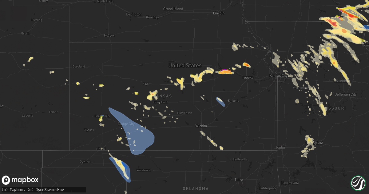
Hail Map in Kansas on June 13, 2024
Get this storm
June 13 map
$229
one time, instant access
Download today. No call, no setup
Keep the $229
Bought the map and want the full workflow? Apply the entire $229 to a subscription within 7 days. None of it is wasted.
Every map, not just this one
This buys you this map. Subscription and you get every map we run, in the markets you choose from a few cities to whole states to nationwide. Plus real-time alerts the moment a storm fires.
Contact data
Name, contact info, occupancy, even credit band for addresses in the footprint. You go from where it hit to who to call.
Become the source they trust
Unlimited branding weather history reports on demand. You already have the documented answer ready for the property owner, and you are the one who showed up with it.
Property data and RoofTrace estimates
Pull up any address you have got, its value and the exact code rules for that jurisdiction, straight from One Click Code. Then RoofTrace estimates the squares, pitch, and roof value, priced the way you price.
Storm reports in Kansas
Kansas
| Date | Description |
|---|---|
| 06/13/20246:50 PM CDT | Report from son of trained spotter. |
| 06/13/20246:43 PM CDT | A local report indicates 1.50 inch wind near 1 S Longford |
| 06/13/20246:43 PM CDT | A local report indicates 1.50 inch wind near 4 NNW Wakefield |
| 06/13/20246:39 PM CDT | Report from mping: quarter |
| 06/13/20246:37 PM CDT | A local report indicates 1.50 inch wind near 4 W Talmage |
| 06/13/20246:34 PM CDT | A local report indicates 1.25 inch wind near 1 SSW Longford |
| 06/13/20246:32 PM CDT | Kddc asos. |
| 06/13/20246:31 PM CDT | Visibility was reported to be one-quarter mile in blowing dust with the high wind. Report was relayed by em. |
| 06/13/20246:17 PM CDT | A local report indicates 60 MPH wind near 2 E Ash Valley |
| 06/13/20246:10 PM CDT | Mesonet station k5sct 1 ese scott state lake. |
| 06/13/20245:37 PM CDT | Time estimated from radar. |
| 06/13/20245:37 PM CDT | Time estimated from radar. |
| 06/13/20245:34 PM CDT | Measured peak wind gust from personal weather station. |
| 06/13/20245:29 PM CDT | A local report indicates 61 MPH wind near 10 W Kalvesta |
| 06/13/20245:27 PM CDT | Reported alongside penny-size hail. |
| 06/13/20245:17 PM CDT | Time estimated from radar. |
| 06/13/20245:16 PM CDT | A local report indicates 59 MPH wind near 1 SW Garden City |
| 06/13/20245:06 PM CDT | Mesonet station up840 9.0 w winona |
| 06/13/20244:44 PM CDT | Mesonet station cw6099 9 sse sharon springs. |
| 06/13/20244:40 PM CDT | [landspout] report received from social media with pictures. |
| 06/13/20244:35 PM CDT | [landspout] report received from social media with pictures. |
| 06/13/20244:30 PM CDT | [landspout] report received from social media with pictures. |
| 06/13/20244:15 PM CDT | Delayed report of three utility poles blown over. |
| 06/13/20244:10 PM CDT | [landspout] report received from social media with a picture. |
| 06/13/20243:46 PM CDT | Dispatch in town. |
| 06/13/20243:05 PM CDT | [landspout] trained spotter reported a landspout in the area that lasted about 10-15 min. |
| 06/13/20243:04 PM CDT | Kksmarie11 reported gust of 66 mph. |
| 06/13/20242:52 PM CDT | Kksleoti31 reported 66 mph gust. |
| 06/12/202411:00 PM CDT | Reported with tree damage. |
| 06/12/20249:07 PM CDT | Fire dept reported a heavy anchored shed was flipped. Time estimated via radar. |
| 06/12/20248:54 PM CDT | Delayed report. Kemp. |
| 06/12/20248:50 PM CDT | Winds 60 to 65 mph. |
| 06/12/20248:49 PM CDT | Corrects previous non-tstm wnd gst report from 5 nnw olpe. Kemp. |
| 06/12/20248:49 PM CDT | Peak wind gust measured from a personal weather station. |
| 06/12/20248:48 PM CDT | Estimated from social media picture. |
| 06/12/20248:48 PM CDT | Report from mping: golf ball |
| 06/12/20248:47 PM CDT | Social media report. |
| 06/12/20248:46 PM CDT | A local report indicates 60 MPH wind near Spivey |
| 06/12/20248:45 PM CDT | A local report indicates 80 MPH wind near Nashville |
| 06/12/20248:45 PM CDT | Delayed report of large tree limbs down some were up to 5 inches in diameter. |
| 06/12/20248:42 PM CDT | A local report indicates 60 MPH wind near 5 SSW Zenda |
| 06/12/20248:39 PM CDT | Social media report. |
| 06/12/20248:38 PM CDT | A local report indicates 60 MPH wind near 1 NNW Kingman |
| 06/12/20248:34 PM CDT | Asos station kp28 medicine lodge. |
| 06/12/20248:30 PM CDT | Pictures submitted via social media show one large tree and limbs |
| 06/12/20248:25 PM CDT | A local report indicates 60 MPH wind near Peabody |
| 06/12/20248:20 PM CDT | Reported from kansas mesonet. |
| 06/12/20248:15 PM CDT | Delayed report. From kansas mesonet. |
| 06/12/20248:15 PM CDT | Peak wind gust measured by personal weather station. |
| 06/12/20248:12 PM CDT | Report from mping: quarter |
| 06/12/20248:09 PM CDT | A local report indicates 1.00 inch wind near Minneapolis |
| 06/12/20248:06 PM CDT | A local report indicates 1.50 inch wind near Minneapolis |
| 06/12/20248:03 PM CDT | A local report indicates 1.00 inch wind near Minneapolis |
| 06/12/20248:03 PM CDT | Report received through mping. |
| 06/12/20248:00 PM CDT | Report from mping. Time estimated based on radar data. |
| 06/12/20247:55 PM CDT | A local report indicates 60 MPH wind near Coldwater |
| 06/12/20247:54 PM CDT | A local report indicates 75 MPH wind near Coats |
| 06/12/20247:53 PM CDT | Report from mping: ping pong ball |
| 06/12/20247:52 PM CDT | A local report indicates 1.50 inch wind near Wamego |
| 06/12/20247:51 PM CDT | A local report indicates 1.00 inch wind near 4 N Niles |
| 06/12/20247:50 PM CDT | Social media report. Time estimated from radar. |
| 06/12/20247:50 PM CDT | Delayed report from wamego. Social media. |
| 06/12/20247:49 PM CDT | Mesonet station up430 1.8 w wellsford |
| 06/12/20247:46 PM CDT | Corrects previous hail report from wamego. |
| 06/12/20247:46 PM CDT | A local report indicates 1.75 inch wind near Louisville |
| 06/12/20247:46 PM CDT | A local report indicates 1.75 inch wind near Wamego |
| 06/12/20247:45 PM CDT | Report from mping: hen egg |
| 06/12/20247:41 PM CDT | Report from mping: half dollar |
| 06/12/20247:39 PM CDT | A local report indicates 1.75 inch wind near 3 W Wamego |
| 06/12/20247:38 PM CDT | A local report indicates 1.25 inch wind near 2 ENE Saint George |
| 06/12/20247:31 PM CDT | Around 55-60 mph reported. |
| 06/12/20247:30 PM CDT | A local report indicates 2.75 inch wind near 6 NNW Saint George |
| 06/12/20247:30 PM CDT | Delayed report from social media. |
| 06/12/20247:28 PM CDT | A local report indicates 1.25 inch wind near 1 ENE Manhattan |
| 06/12/20247:25 PM CDT | 50 mph wind gusts with the hail. Tree limbs down closer to bennington. |
| 06/12/20247:24 PM CDT | Time estimated from radar. Social media report. |
| 06/12/20247:24 PM CDT | Report from mping: golf ball |
| 06/12/20247:20 PM CDT | Report from mping: golf ball |
| 06/12/20247:18 PM CDT | Report from mping: half dollar |
| 06/12/20247:17 PM CDT | Spotter network. Quarter to tennis ball size hail. |
| 06/12/20247:16 PM CDT | Social media picture. |
| 06/12/20247:16 PM CDT | A local report indicates 1.50 inch wind near 4 NNE Niles |
| 06/12/20247:16 PM CDT | A local report indicates 1.75 inch wind near 1 ENE Manhattan |
| 06/12/20247:15 PM CDT | Report from mping: quarter |
| 06/12/20247:15 PM CDT | Delayed report. 2 inch hail in north manhattan. |
| 06/12/20247:13 PM CDT | Report from mping: quarter |
| 06/12/20247:13 PM CDT | Report from mping: half dollar |
| 06/12/20247:12 PM CDT | Report from mping: quarter |
| 06/12/20247:12 PM CDT | Report from mping: half dollar |
| 06/12/20247:10 PM CDT | A local report indicates 1.00 inch wind near 2 WNW Manhattan |
| 06/12/20247:10 PM CDT | A local report indicates 1.00 inch wind near 2 NNW Manchester |
| 06/12/20247:09 PM CDT | Delayed report via social media showing a hailstone measuring 3.5 inches in diameter. |
| 06/12/20247:08 PM CDT | Report from mping: quarter |
| 06/12/20247:00 PM CDT | Measured peak wind gust from a personal weather station. |
All States Impacted by Hail Map on June 13, 2024
Cities Impacted by Hail Map on June 13, 2024
- Hays, KS
- Ellis, KS
- Brownell, KS
- South Elgin, IL
- Saint Charles, IL
- Elgin, IL
- Wayne, IL
- Bartlett, IL
- Hanover Park, IL
- Carol Stream, IL
- West Chicago, IL
- Marquette, MI
- Negaunee, MI
- Skandia, MI
- Deerton, MI
- Eben Junction, MI
- Chatham, MI
- Trenary, MI
- Rumely, MI
- Munising, MI
- Wetmore, MI
- Seney, MI
- Manistique, MI
- McMillan, MI
- Newberry, MI
- Germfask, MI
- Rapid River, MI
- Gulliver, MI
- Panama City, FL
- Eckerman, MI
- Mims, FL
- Kinross, MI
- Brimley, MI
- Vona, CO
- Cincinnati, IA
- Centerville, IA
- Exline, IA
- Seymour, IA
- Stratton, CO
- Moulton, IA
- Unionville, MO
- Coatsville, MO
- Livonia, MO
- Glenwood, MO
- Queen City, MO
- Lancaster, MO
- Leoti, KS
- Bloomfield, IA
- Ottumwa, IA
- Eldon, IA
- Manteno, IL
- Floris, IA
- Green Castle, MO
- Novinger, MO
- Downing, MO
- Selma, IA
- Batavia, IA
- Libertyville, IA
- Fairfield, IA
- Douds, IA
- Grant Park, IL
- Momence, IL
- Arapahoe, CO
- Memphis, MO
- Greentop, MO
- Baring, MO
- Kirksville, MO
- Lake Village, IN
- Lowell, IN
- Schneider, IN
- Beecher, IL
- Sharon Springs, KS
- Rutledge, MO
- Edina, MO
- Wallace, KS
- Cantril, IA
- Birmingham, IA
- Keosauqua, IA
- Milton, IA
- Brashear, MO
- Russell, KS
- Scott City, KS
- Pulaski, IA
- Oakley, KS
- Hurdland, MO
- Mishawaka, IN
- South Bend, IN
- Granger, IN
- Elkhart, IN
- Osceola, IN
- Bristol, IN
- Middlebury, IN
- Goshen, IN
- Bonaparte, IA
- Bison, KS
- Otis, KS
- Hoisington, KS
- Mount Sterling, IA
- Demotte, IN
- Fair Oaks, IN
- Knox City, MO
- Arbela, MO
- Farmington, IA
- Luray, MO
- Kahoka, MO
- Olmitz, KS
- Stockport, IA
- Hillsboro, IA
- Garden City, KS
- Hebron, IN
- Dorrance, KS
- Bunker Hill, KS
- Donnellson, IA
- Lockridge, IA
- La Belle, MO
- Wayland, MO
- Revere, MO
- Ewing, MO
- Lewistown, MO
- Wheatfield, IN
- Winona, KS
- Beverly, KS
- Monticello, MO
- Maywood, MO
- Durham, MO
- Argyle, IA
- Montrose, IA
- Keokuk, IA
- Nauvoo, IL
- Hamilton, IL
- Warsaw, IL
- Basco, IL
- Alexandria, MO
- Carthage, IL
- Elvaston, IL
- Lincoln, KS
- Green City, MO
- Rensselaer, IN
- Mount Pleasant, IA
- Newark, MO
- Wilson, KS
- La Grange, MO
- Rush Center, KS
- Solomon, KS
- Minneapolis, KS
- Bennington, KS
- Ulysses, KS
- Limon, CO
- La Crosse, KS
- Mount Union, IA
- Carman, IL
- West Burlington, IA
- Burlington, IA
- Wyaconda, MO
- Gorin, MO
- Clay Center, KS
- Longford, KS
- New London, IA
- Albert, KS
- Nekoma, KS
- Alexander, KS
- Great Bend, KS
- Sublette, KS
- Ness City, KS
- Wakefield, KS
- Brookville, KS
- New Cambria, KS
- Salina, KS
- Ellsworth, KS
- Genoa, CO
- Burdett, KS
- Cimarron, KS
- Jetmore, KS
- Ingalls, KS
- Wright, KS
- Dodge City, KS
- Ensign, KS
- Abilene, KS
- Rozel, KS
- Larned, KS
- Milford, KS
- Hanston, KS
- West Point, IA
- Morning Sun, IA
- Yarmouth, IA
- Saint Patrick, MO
- Ellinwood, KS
- Hudson, KS
- Riley, KS
- Danville, IA
- Lindon, CO
- Middletown, IA
- Gladstone, IL
- Bronson, MI
- Winfield, IA
- Canton, MO
- Good Hope, IL
- Bushnell, IL
- Garfield, KS
- Kinsley, KS
- St John, KS
- Pawnee Rock, KS
- Milan, MO
- Gibbs, MO
- Offerle, KS
- Sperry, IA
- Mediapolis, IA
- Manhattan, KS
- La Plata, MO
- Nara Visa, NM
- Ford, KS
- Bucklin, KS
- Spearville, KS
- Minneola, KS
- Mullinville, KS
- Quincy, IL
- Ursa, IL
- Sylvia, KS
- Oakville, IA
- Wapello, IA
- Saint George, KS
- Wamego, KS
- Gypsum, KS
- Greensburg, KS
- Meade, KS
- Ransom, KS
- Utica, KS
- Clayton, IL
- Fowler, IL
- Liberty, IL
- Camp Point, IL
- Sylvan Grove, KS
- Yerington, NV
- Fowler, KS
- Prairie City, IL
- Lewis, KS
- Williamstown, MO
- Englewood, KS
- Ashland, KS
- Haviland, KS
- Sun City, KS
- Wilmore, KS
- Coldwater, KS
- Protection, KS
- Stronghurst, IL
- Novelty, MO
- Tampa, KS
- Wakeeney, KS
- New Boston, MO
- Winigan, MO
- Browning, MO
- Timewell, IL
- Mount Sterling, IL
- Elmer, MO
- Versailles, IL
- Brookfield, MO
- Belvue, KS
- Durham, KS
- Ainsworth, IA
- Ethel, MO
- Onaga, KS
- Strong City, KS
- Elmdale, KS
- Cuba, IL
- Francesville, IN
- Keithsburg, IL
- Seaton, IL
- Blandinsville, IL
- Sciota, IL
- Washington, IA
- Crawfordsville, IA
- Paxico, KS
- Cottonwood Falls, KS
- Rosston, OK
- Buffalo, OK
- Havensville, KS
- Soldier, KS
- Delia, KS
- Emmett, KS
- Avon, IL
- Smithfield, IL
- Aledo, IL
- Viola, IL
- Alexis, IL
- Macomb, IL
- Liberal, KS
- Arenzville, IL
- Beardstown, IL
- Adrian, TX
- Saint Marys, KS
- Fort Madison, IA
- Plevna, KS
- Turon, KS
- Salem, IA
- New Cambria, MO
- Bucklin, MO
- Atlanta, MO
- Leonard, MO
- Shelbyville, MO
- Bethel, MO
- Stafford, KS
- Holton, KS
- Mayetta, KS
- Lucas, KS
- Amarillo, TX
- Marietta, IL
- Forgan, OK
- Callao, MO
- Linneus, MO
- Bevier, MO
- Purdin, MO
- Columbus Junction, IA
- Lyndon, KS
- Lenexa, KS
- Richmond, MO
- Quenemo, KS
- Hale, MO
- Eudora, KS
- Dumas, TX
- Olathe, KS
- Norborne, MO
- Kansas City, MO
- Reading, KS
- Shawnee, KS
- Burns, KS
- Osage City, KS
- Independence, MO
- Perryton, TX
- Emporia, KS
- Newton, KS
- Mission, KS
- Laverne, OK
- Vassar, KS
- Lake City, KS
- Mount Hope, KS
- Spivey, KS
- Spearman, TX
- Sibley, MO
- Sedgwick, KS
- Balko, OK
- De Soto, KS
- Colwich, KS
- Cheney, KS
- Murdock, KS
- Isabel, KS
- Kingman, KS
- Overbrook, KS
- Kansas City, KS
- Channing, TX
- Baldwin City, KS
- Huntsville, MO
- New Windsor, IL
- North Henderson, IL
- Ludlow, MO
- Kingston, MO
- Hillsboro, KS
- Lehigh, KS
- Denison, KS
- Marceline, MO
- Macon, MO
- Winchester, IL
- Monmouth, IL
- Arlington, KS
- Pekin, IL
- Hunnewell, MO
- Shelbina, MO
- Emden, MO
- Freedom, OK
- Valley Falls, KS
- Hoyt, KS
- Jacksonville, IL
- Alexander, IL
- Dawn, MO
- Breckenridge, MO
- Braymer, MO
- Bogard, MO
- Carrollton, MO
- Higbee, MO
- Moberly, MO
- Clifton Hill, MO
- Tremont, IL
- Clark, MO
- Galesburg, IL
- Gerlaw, IL
- Rio, IL
- Monticello, IN
- Buffalo, IN
- Winamac, IN
- Wheeling, MO
- Chula, MO
- Paris, MO
- Salisbury, MO
- Laclede, MO
- East Peoria, IL
- Rothville, MO
- Beaver, OK
- Galva, IL
- Altona, IL
- Alpha, IL
- Oneida, IL
- Woodhull, IL
- Litchfield, IL
- Raymond, IL
- Groveland, IL
- Monroe City, MO
- Stoutsville, MO
- Crown Point, IN
- Meadville, MO
- Sturgeon, MO
- Centralia, MO
- Hallsville, MO
- Gower, MO
- Agency, MO
- New Berlin, IL
- Springfield, IL
- Dahinda, IL
- Williamsfield, IL
- Deer Creek, IL
- Morton, IL
- Fowler, IN
- Speer, IL
- Princeville, IL
- Edelstein, IL
- Chillicothe, IL
- Edgerton, MO
- Gilson, IL
- Minonk, IL
- Dearborn, MO
- Cowgill, MO
- Hardin, MO
- Trimble, MO
- Victoria, IL
- Mackinaw, IL
- Toulon, IL
- Mulvane, KS
- Wataga, IL
- Henderson, IL
- Chillicothe, MO
- Sumner, MO
- Knoxville, IL
- Utica, MO
- El Paso, IL
- Flanagan, IL
- Dunlap, IL
- Camden Point, MO
- Smithville, MO
- Excello, MO
- Mendon, MO
- Perry, MO
- Bradford, IL
- Follett, TX
- Rushville, MO
- De Kalb, MO
- Faucett, MO
- Carlock, IL
- Cairo, MO
- Triplett, MO
- Pembroke Township, IL
- Belle Plaine, KS
- Lexington, MO
- Baileyville, KS
- Mazon, IL
- Gardner, IL
- Platte City, MO
- Wyoming, IL
- Sparland, IL
- Boswell, IN
- Shattuck, OK
- Darrouzett, TX
- Higgins, TX
- Lipscomb, TX
- Arnett, OK
- Higginsville, MO
- Braceville, IL
- Dover, MO
- Udall, KS
- Wilmington, IL
- Essex, IL
- Braidwood, IL
- Bonfield, IL
- Gridley, IL
- Derby, KS
- Haysville, KS
- Peck, KS
- Lexington, IL
- Colfax, IL
- Liberty, MO
- Loveland, CO
- Winfield, KS
- Mayview, MO
- Centralia, KS
- Drake, CO
- De Witt, MO
- Corder, MO
- Bosworth, MO
- Brunswick, MO
- Kankakee, IL
- Bradley, IL
- Bourbonnais, IL
- Keytesville, MO
- Goodfield, IL
- Congerville, IL
- Seneca, KS
- Axtell, KS
- Dexter, KS
- Trenton, MO
- Lyons, CO
- Chatsworth, IL
- Columbia, MO
- Cameron, MO
- Benson, IL
- Cedar Vale, KS
- Clarksdale, MO
- Roseville, IL
- Cedar Lake, IN
- Hiawatha, KS
- Anchor, IL
- Plattsburg, MO
- Paxton, IL
- Melvin, IL
- Gibson City, IL
- Buckner, MO
- Streator, IL
- Concordia, MO
- Ambia, IN
- Ransom, IL
- New Franklin, MO
- Rocheport, MO
- Bates City, MO
- Holden, MO
- Odessa, MO
- Sabetha, KS
- Williamsport, IN
- Hoopeston, IL
- Miami, MO
- Oak Grove, MO
- Napoleon, MO
- Polo, MO
- Saint Joseph, MO
- Easton, MO
- Oneida, KS
- Fulton, MO
- Auxvasse, MO
- Kingdom City, MO
- Lawson, MO
- Rayville, MO
- Morris, IL
- Verona, IL
- Canadian, TX
- Bern, KS
- Dwight, IL
- Kinsman, IL
- Glasgow, MO
- Waverly, MO
- Centerview, MO
- Marshall, MO
- Morrill, KS
- Edwards, MO
- Stover, MO
- Climax Springs, MO
- Clinton, MO
- Oregon, MO
- Troy, KS
- Urich, MO
- Montrose, MO
- Missouri City, MO
- Henrietta, MO
- Boonville, MO
- Roach, MO
- Gravois Mills, MO
- White Cloud, KS
- Canton, IL
- Holt, MO
- Kearney, MO
- Macks Creek, MO
- Coldwater, MI
- Brooksville, FL
- Arkansas City, KS
- Pine Village, IN
- Lathrop, MO
- Grain Valley, MO
- Hughesville, MO
- Sedalia, MO
- Wathena, KS
- Whiteman Air Force Base, MO
- La Monte, MO
- Knob Noster, MO
- Green Ridge, MO
- Windsor, MO
- Warrensburg, MO
- Robinson, KS
- Leeton, MO
- Kingsville, MO
- Green Valley, IL
- Lincoln, MO
- Versailles, MO
- Bluffs, IL
- Cole Camp, MO
- Wellington, MO
- Calhoun, MO
- Monon, IN
- Delavan, IL
- Tina, MO
- Camdenton, MO
- Preston, MO
- Quincy, MO
- Warsaw, MO
- La Fayette, IL
- Osceola, MO
- Cross Timbers, MO
- Laura, IL
- Attica, IN
- Walnut Grove, MO
- Secor, IL
- Ash Grove, MO
- Willard, MO
- Clarksburg, MO
- Fortuna, MO
- Pleasant Plains, IL
- Springfield, MO
- Hudson, IL
- Sheffield, IL
- Wyanet, IL
- Manlius, IL
- Princeton, IL
- Bois D Arc, MO
- Rossville, IL
- Saint Anne, IL
- Buffalo, MO
- Tipton, MO
- Latham, MO
- California, MO
- Peotone, IL
- Mora, MO
- Smithton, MO
- Sweet Springs, MO
- Republic, MO
- Brookline, MO
- Nixa, MO
- Aurora, MO
- Billings, MO
- Marionville, MO
- Ionia, MO
- Clever, MO
- Ozark, MO
- Verona, MO
- Logansport, IN
- Crane, MO
- Wenona, IL
- Saint David, IL
- Galena, MO
- Eureka, IL
- Danvers, IL
- Roanoke, IL
- Reddick, IL
- Coal City, IL
- Chenoa, IL
- Coatsburg, IL
- Champaign, IL
- Urbana, IL
- Minier, IL
- Atlanta, IL
- Lincoln, IL
- Crawfordsville, IN
- Nunn, CO
- Niota, IL


