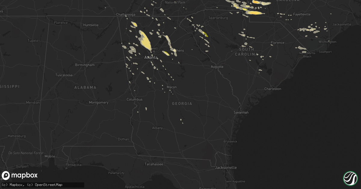
Hail Map in Georgia on June 13, 2013
Get this storm
June 13 map
$229
one time, instant access
Download today. No call, no setup
Keep the $229
Bought the map and want the full workflow? Apply the entire $229 to a subscription within 7 days. None of it is wasted.
Every map, not just this one
This buys you this map. Subscription and you get every map we run, in the markets you choose from a few cities to whole states to nationwide. Plus real-time alerts the moment a storm fires.
Contact data
Name, contact info, occupancy, even credit band for addresses in the footprint. You go from where it hit to who to call.
Become the source they trust
Unlimited branding weather history reports on demand. You already have the documented answer ready for the property owner, and you are the one who showed up with it.
Property data and RoofTrace estimates
Pull up any address you have got, its value and the exact code rules for that jurisdiction, straight from One Click Code. Then RoofTrace estimates the squares, pitch, and roof value, priced the way you price.
Storm reports in Georgia
Georgia
| Date | Description |
|---|---|
| 06/13/20136:51 PM CDT | Several large trees are down near north ridge and roswell roads. |
| 06/13/20136:50 PM CDT | This wind was recorded at peachtree dekalb airport. |
| 06/13/20136:50 PM CDT | Several trees are down across sandy springs. |
| 06/13/20136:50 PM CDT | Clarke county 911 reports over 30 trees are down county wide. . |
| 06/13/20136:45 PM CDT | Three 15 year old trees came down near southwick and ethridge drive. A nearby home had its shutters blown off by the wind. |
| 06/13/20136:45 PM CDT | Public reports 2 foot wide tree snapped off in their yard. |
| 06/13/20136:41 PM CDT | The tornado that moved through cherokee and cobb counties tracked into fulton county at the chattahoochee river near johnson ferry road and riverside drive. The tornado |
| 06/13/20136:40 PM CDT | Several trees snapped and uprooted in the area of kennesaw state university. |
| 06/13/20136:35 PM CDT | Numerous trees and powerlines were reported down county wide by the 911 center. |
| 06/13/20136:30 PM CDT | The tornado that touched down just inside the cherokee county line moved into cobb county and strengthened to an ef-1. The tornado tracked southeast through cobb county |
| 06/13/20136:30 PM CDT | An nws survey team determined that a second tornado touched down within a tenth of a mile of the cherokee-cobb county line just inside the cherokee county line along wo |
| 06/13/20136:27 PM CDT | Several large trees across barrow county are down per ema. |
| 06/13/20136:22 PM CDT | *** 2 inj *** cherokee em reports 2 non life threatening injuries due to downed trees in the town of canton. |
| 06/13/20136:17 PM CDT | A large number of trees are down on homes...cars...and powerlines. There are a number of power outages. |
| 06/13/20136:15 PM CDT | The 911 center reported numerous trees down in the town of white. |
| 06/13/20136:10 PM CDT | A tree was reported down 7 miles north of canton. |
| 06/13/20136:03 PM CDT | Tv media passed along a 59 mph wind gust from a viewers davis weather station. |
| 06/13/20136:00 PM CDT | The tornado touched down near the intersection of patriot trail and rampley trail...causing tree damage as it headed south towards canton. Along marietta rd and hickory |
| 06/13/20135:36 PM CDT | The 911 center reported many trees were down across the county and especially to the northeast of dahlonega. |
| 06/13/20135:25 PM CDT | Numerous trees and powerlines were reported down across the county including a few along high 61. |
| 06/13/20135:25 PM CDT | The public reported an estimated wind gust in downtown dahlonega of 60 mph. Some tree limbs were down. |
| 06/13/20135:25 PM CDT | Several trees were reported down in the southwest part of the county. |
| 06/13/20135:12 PM CDT | Trees down. One on a house. |
| 06/13/20135:05 PM CDT | The 911 center reported numerous trees and powerlines down along highway 60 in the south part of the county. |
| 06/13/20134:55 PM CDT | Multiple trees and powerlines down near lake burton. |
| 06/13/20134:54 PM CDT | Local 911 reported that trees were down countywide with many taking down power lines. |
| 06/13/20134:49 PM CDT | Several trees were reported down in the southwest part of the county. |
| 06/13/20134:45 PM CDT | Numerous trees down across the county particularly hiawassee area. |
| 06/13/20134:43 PM CDT | Two trees downed just north of downtown dalton near n thorton ave and w tyler st |
| 06/12/20139:30 PM CDT | Several trees were reported down by the 911 center with a few each at mlk road and 8th street. |
| 06/12/20138:55 PM CDT | A couple of trees reported down across macon. |
| 06/12/20138:30 PM CDT | Around a dozen trees were reported down across the county including several along highway 29 and a few more along highway 34 west. One tree was also reported on a house |
| 06/12/20138:22 PM CDT | Several trees reported down county wide. |
| 06/12/20137:59 PM CDT | Several trees are reported down across shiloh road and highway 42. |
| 06/12/20137:36 PM CDT | Several trees are reported down on huey road...hillside drive and reynolds road. Some power outages reported. |
| 06/12/20137:35 PM CDT | Numerous trees and powerlines were reported down by the 911 center from jonesboro southward through the panhandle of clayton county. |
| 06/12/20137:10 PM CDT | Public reported 1 inch hail. |
| 06/12/20137:04 PM CDT | Bobo road is closed due to several trees wtih power lines down across the road. |
| 06/12/20137:00 PM CDT | A local report indicates 1.00 inch wind near CEDARTOWN |
| 06/12/20137:00 PM CDT | Tree down on atlanta highway |
| 06/12/20137:00 PM CDT | Trees snapped and uprooted across bolton road between marietta blvd and road. Power lines and lines down also. |
All States Impacted by Hail Map on June 13, 2013
Cities Impacted by Hail Map on June 13, 2013
- Big Timber, MT
- Wilsall, MT
- Ridgeway, SC
- Maryville, TN
- Tallassee, TN
- Townsend, TN
- Suches, GA
- Lehigh Acres, FL
- Big Springs, NE
- Brundidge, AL
- Manning, SC
- Sumter, SC
- Knoxville, TN
- Bessemer City, NC
- Haxtun, CO
- Reed Point, MT
- Rapelje, MT
- Zapata, TX
- Roma, TX
- Mineral, VA
- Orange, VA
- Crook, CO
- Sedgwick, CO
- Chadds Ford, PA
- Harrodsburg, KY
- Danville, KY
- Junction City, KY
- Perryville, KY
- Idalia, CO
- Stratton, CO
- Kirk, CO
- Walkerton, VA
- Saint Stephens Church, VA
- Bruington, VA
- Dunnsville, VA
- Morganton, GA
- Callaway, MD
- Lusby, MD
- Leonardtown, MD
- Great Mills, MD
- California, MD
- Valley Lee, MD
- Hollywood, MD
- Lexington Park, MD
- Patuxent River, MD
- Dowell, MD
- Solomons, MD
- Owenton, KY
- Axton, VA
- Broadview, MT
- Lavina, MT
- Ryegate, MT
- Tarboro, NC
- Greenville, NC
- Albemarle, NC
- New London, NC
- Gunlock, KY
- Snow Camp, NC
- Graham, NC
- Fleming, CO
- Saint Albans, WV
- Scott Depot, WV
- Hurricane, WV
- Preston, GA
- Buena Vista, GA
- Newark, DE
- Lincoln University, PA
- West Grove, PA
- Wilmington, DE
- Hockessin, DE
- Avondale, PA
- Landenberg, PA
- Kennett Square, PA
- Toughkenamon, PA
- Conowingo, MD
- Whiteford, MD
- Darlington, MD
- Anderson, SC
- Honea Path, SC
- Belton, SC
- Williamston, SC
- Midway, TN
- Bulls Gap, TN
- Mosheim, TN
- Mohawk, TN
- Acton, MT
- Shawmut, MT
- Melville, MT
- Musselshell, MT
- Shepherd, MT
- Worden, MT
- Colby, KS
- Levant, KS
- Atwood, KS
- Herndon, KS
- Oberlin, KS
- Brewster, KS
- Coolville, OH
- Pomeroy, OH
- Flint Hill, VA
- Washington, VA
- Painter, VA
- Cartersville, GA
- Marietta, GA
- Kennesaw, GA
- Roswell, GA
- Ranger, GA
- White, GA
- Woodstock, GA
- Waleska, GA
- Acworth, GA
- Ball Ground, GA
- Fairmount, GA
- Canton, GA
- Clearmont, WY
- Decker, MT
- Sheridan, WY
- Conyers, GA
- Charlotte, NC
- Mount Holly, NC
- Stanley, NC
- Harrisburg, NC
- Gastonia, NC
- Belmont, NC
- Huntersville, NC
- Walker, WV
- Buckingham, VA
- Gladstone, VA
- Wingina, VA
- Stanford, KY
- Fishing Creek, MD
- Vesuvius, VA
- Roseland, VA
- Andalusia, AL
- Holstein, NE
- Roseland, NE
- Ayr, NE
- Manchester, MD
- Colstrip, MT
- Forsyth, MT
- Cave Spring, GA
- Cedartown, GA
- Pinnacle, NC
- Billings, MT
- Sevierville, TN
- Cosby, TN
- Dandridge, TN
- Kodak, TN
- Newport, TN
- Byers, CO
- Roundup, MT
- Harmony, NC
- Hamptonville, NC
- Birmingham, AL
- Chillicothe, OH
- Seymour, TN
- Rutledge, GA
- Rocky Ford, CO
- Winnsboro, SC
- New Windsor, MD
- Finksburg, MD
- Reisterstown, MD
- Union Bridge, MD
- Westminster, MD
- Hickory, NC
- Conover, NC
- Five Points, AL
- Fort Davis, TX
- Rock, WV
- Lashmeet, WV
- Spanishburg, WV
- Beeson, WV
- Hardin, MT
- Crow Agency, MT
- Rosebud, MT
- Busby, MT
- Volborg, MT
- Marietta, PA
- Mount Joy, PA
- Columbia, PA
- Newland, NC
- Big Creek, KY
- Oneida, KY
- Manchester, KY
- Appomattox, VA
- Dillwyn, VA
- Spotsylvania, VA
- Partlow, VA
- Bumpass, VA
- Tyler, MN
- Ruthton, MN
- Bowdon, GA
- Fort Smith, MT
- Saint Xavier, MT
- Lodge Grass, MT
- Garryowen, MT
- Glyndon, MD
- Keymar, MD
- Farmville, VA
- Cumberland, VA
- Madison Heights, VA
- Concord, VA
- Amherst, VA
- Blue Ridge, VA
- Montvale, VA
- Coleman Falls, VA
- Big Island, VA
- Natural Bridge Station, VA
- Bedford, VA
- Ranchester, WY
- Bybee, TN
- Meridian, MS
- Greycliff, MT
- Pendleton, SC
- Liberty, SC
- Elizabethtown, NC
- Bladenboro, NC
- Clarkton, NC
- Vinton, OH
- Fork Union, VA
- Bremo Bluff, VA
- Gilmore City, IA
- Campton, KY
- Millville, NJ
- Bridgeton, NJ
- Ruther Glen, VA
- Beaverdam, VA
- Montpelier, VA
- Wild Horse, CO
- Kit Carson, CO
- Old Fort, TN
- Cleveland, TN
- Hamilton, OH
- Oak Vale, MS
- Alpine, TX
- Timberlake, NC
- Sabina, OH
- Wray, CO
- Campbell, NE
- Juniata, NE
- Kenesaw, NE
- Bladen, NE
- Minden, NE
- Heartwell, NE
- Hastings, NE
- Miles City, MT
- Moon, VA
- Basin, WY
- Otto, WY
- Burlington, WY
- Madisonville, TN
- Tellico Plains, TN
- Custer, MT
- Burlington, CO
- Bethune, CO
- Felton, PA
- Wrightsville, PA
- York, PA
- Red Lion, PA
- Windsor, PA
- Dawsonville, GA
- Rockville, VA
- Manakin Sabot, VA
- Moorefield, NE
- Stockville, NE
- Due West, SC
- Greenwood, SC
- Abbeville, SC
- Browns Summit, NC
- Gibsonville, NC
- Elon, NC
- Burlington, NC
- Reidsville, NC
- Troy, AL
- Narrows, VA
- Parkman, WY
- Timmonsville, SC
- Marathon, TX
- Monticello, GA
- Covington, GA
- Greenwich, NJ
- Vineland, NJ
- Indianola, NE
- Bartley, NE
- Quarryville, PA
- Kirkwood, PA
- Christiana, PA
- Odenville, AL
- Springville, AL
- Tallassee, AL
- Notasulga, AL
- Dadeville, AL
- Camp Hill, AL
- Roberts, MT
- Blountsville, AL
- Blacksburg, VA
- Moneta, VA
- Paris, KY
- Elizabethton, TN
- Cody, WY
- Dahlonega, GA
- Arvonia, VA
- Akron, CO
- Sterling, CO
- Otis, CO
- Guysville, OH
- Shade, OH
- Albany, OH
- Athens, OH
- Wayside, WV
- Thomaston, GA
- Meansville, GA
- Molena, GA
- Hoffman, NC
- Garland, NC
- Woodrow, CO
- Forsyth, GA
- Jonesville, VA
- Seneca, SC
- Central, SC
- Fort Valley, GA
- Cochranville, PA
- Bostic, NC
- Adairsville, GA
- Dacula, GA
- Lawrenceville, GA
- Grayson, GA
- Loganville, GA
- Monroe, GA
- Huntley, MT
- Gillsville, GA
- Gainesville, GA
- Talmo, GA
- Laurel, MT
- Joliet, MT
- Greybull, WY
- Shell, WY
- Manderson, WY
- Julesburg, CO
- Clay Center, NE
- Rydal, GA
- Jasper, GA
- Talking Rock, GA
- Resaca, GA
- Calhoun, GA
- Atlanta, GA
- Rockmart, GA
- Pfafftown, NC
- Eden, NC
- Martinsville, VA
- Tuckasegee, NC
- Gray, GA
- McArthur, OH
- Ray, OH
- Philadelphia, TN
- Sweetwater, TN
- Marion, AL
- Haigler, NE
- Surgoinsville, TN
- Eidson, TN
- Jonesborough, TN
- Limestone, TN
- Telford, TN
- Unicoi, TN
- Saint Francis, KS
- Ridgeway, VA
- Statesville, NC
- Hysham, MT
- Ingomar, MT
- Red Lodge, MT
- Kannapolis, NC
- Mount Pleasant, NC
- Concord, NC
- Dallas, GA
- Buchanan, GA
- Temple, GA
- Aragon, GA
- Parkersburg, WV
- Washington, WV
- Little Hocking, OH
- Maxwelton, WV
- White Sulphur Springs, WV
- Lewisburg, WV
- Renick, WV
- Williamsburg, WV
- Frankford, WV
- Holly Hill, SC
- Eutawville, SC
- Centreville, AL
- Yadkinville, NC
- East Bend, NC
- Boonville, NC
- Lutherville Timonium, MD
- Owings Mills, MD
- Cockeysville, MD
- Hamilton, GA
- Pigeon Forge, TN
- Covington, VA
- Hot Springs, VA
- Rockingham, NC
- Marston, NC
- Lynchburg, VA
- Monroe, VA
- Drayden, MD
- Tall Timbers, MD
- Park Hall, MD
- Marshall, NC
- Bloomfield, KY
- Delta, PA
- Franklin, GA
- Hogansville, GA
- Pendergrass, GA
- Woodford, VA
- Port Royal, VA
- Fredericksburg, VA
- Rappahannock Academy, VA
- Hillsville, VA
- Laurel Fork, VA
- Columbus, MT
- Livingston, MT
- Villa Rica, GA
- Rocky Face, GA
- Tunnel Hill, GA
- Chatsworth, GA
- Ringgold, GA
- Dalton, GA
- Radford, VA
- Jarrettsville, MD
- Street, MD
- Forest Hill, MD
- Wagram, NC
- Laurinburg, NC
- Whipple, OH
- Cherokee, NC
- Church Hill, MD
- Sudlersville, MD
- Peebles, OH
- Delmont, NJ
- Raeford, NC
- Exmore, VA
- Quinby, VA
- Belle Haven, VA
- Melfa, VA
- Middlebourne, WV
- Molt, MT
- Stinnett, KY
- Hyden, KY
- Macon, GA
- Hampton, GA
- Stockbridge, GA
- Mcdonough, GA
- Le Roy, WV
- Roan Mountain, TN
- Bakersville, NC
- Midland, NC
- Montgomery, AL
- Louisa, VA
- Bogart, GA
- Athens, GA
- Dorchester, NE
- Crete, NE
- Watkinsville, GA
- Statham, GA
- Punta Gorda, FL
- Monroe, NC
- Crouse, NC
- Dallas, NC
- Matthews, NC
- Kings Mountain, NC
- Peachland, NC
- Casar, NC
- Lincolnton, NC
- Wingate, NC
- Indian Trail, NC
- Cherryville, NC
- Lawndale, NC
- Pineville, NC
- Marshville, NC
- Cramerton, NC
- Shelby, NC
- Camden, SC
- New Park, PA
- Airville, PA
- Stewartstown, PA
- Omaha, GA
- Lumpkin, GA
- Nixon, TX
- Claremont, NC
- Laurel, MS
- Shubuta, MS
- Marshall, VA
- Rileyville, VA
- Hume, VA
- Huntly, VA
- Luray, VA
- Bentonville, VA
- Friendsville, TN
- Greenback, TN
- Philadelphia, PA
- Willard, NC
- Peachtree Corners, GA
- Louisville, MS
- Newnan, GA
- Christiansburg, VA
- Altoona, AL
- Oneonta, AL
- Germanton, NC
- Walnut Cove, NC
- Belews Creek, NC
- Dugspur, VA
- Willis, VA
- Belpre, OH
- Reedsville, OH
- Belleville, WV
- Mineral Wells, WV
- Booneville, KY
- Huddleston, VA
- Lynch Station, VA
- Edgar, MT
- Bridger, MT
- Moravian Falls, NC
- Taylorsville, NC
- Lenoir, NC
- Boomer, NC
- Mount Vernon, KY
- Ballantine, MT
- Fall Branch, TN
- Union Springs, AL
- Foster, WV
- Peytona, WV
- Powder Springs, TN
- Washburn, TN
- Luttrell, TN
- Maynardville, TN
- Talladega, AL
- Chickamauga, GA
- Pipestem, WV
- Jumping Branch, WV
- King, NC
- Tobaccoville, NC
- Gresham, NE
- Waco, NE
- Armuchee, GA
- Summerville, GA
- Morrow, GA
- Jonesboro, GA
- Stromsburg, NE
- Blacksburg, SC
- Smyrna, SC
- Reliance, TN
- Fackler, AL
- Woodland, AL
- Heflin, AL
- Graham, AL
- Ranburne, AL
- Ellisville, MS
- Bishop, GA
- Unadilla, NE
- Butler, AL
- Toxey, AL
- Holbrook, NE
- Arapahoe, NE
- Lawrenceburg, KY
- Chaplin, KY
- Edgewater, MD
- Annapolis, MD
- Riva, MD
- Davidsonville, MD
- Knoxville, GA
- Frederick, MD
- Quitman, MS
- Vossburg, MS
- Willisburg, KY
- Ellerbe, NC
- Elba, AL
- Unionville, VA
- Centre, AL
- Jackson, KY
- Atglen, PA
- Parkesburg, PA
- Plainview, NE
- Neligh, NE
- Newport, VA
- Donalds, SC
- London, KY
- Beach Haven, NJ
- McCormick, SC
- Warner Robins, GA
- The Rock, GA
- Nancy, KY
- Irvine, KY
- Ravenna, KY
- New Canton, VA
- Columbia, VA
- Chuckey, TN
- Bearcreek, MT
- Belfry, MT
- Culbertson, NE
- Maywood, NE
- McCook, NE
- Elk Park, NC
- Banner Elk, NC
- Bandy, VA
- North Tazewell, VA
- Arcadia, FL
- Cuba, AL
- Ward, AL
- Westhoff, TX
- Cincinnati, OH
- Loveland, OH
- Coffeeville, AL
- Thomasville, AL
- Oak Hill, WV
- Fayetteville, WV
- Vale, NC
- Buchanan, VA
- Summersville, WV
- Great Falls, SC
- Talmage, NE
- Fitzgerald, GA
- Gordonsville, VA
- King George, VA
- Colonial Beach, VA
- Ordway, CO
- Coatesville, PA
- Downingtown, PA
- West Chester, PA
- Thorndale, PA
- Eastover, SC
- Lugoff, SC
- Columbia, SC
- Port Elizabeth, NJ
- Richmond, KY
- Kinzers, PA
- Gap, PA
- Egg Harbor Township, NJ
- Longport, NJ
- Linwood, NJ
- Margate City, NJ
- Somers Point, NJ
- Ocean City, NJ
- Ivanhoe, NC
- Council, NC
- Atkinson, NC
- Kelly, NC
- Gulston, KY
- Cawood, KY
- Harlan, KY
- Mary Alice, KY
- Woodbine, NJ
- Olin, NC
- Fort Peck, MT
- Brodhead, KY
- Yuma, CO
- Eclectic, AL
- New Marshfield, OH
- Richfield, NC
- Concord, GA
- Gay, GA
- Cartersville, VA
- Powhatan, VA
- Oceana, WV
- Fawn Grove, PA
- Pylesville, MD
- Lovell, WY
- Onancock, VA
- Hacksneck, VA
- Carson, MS
- Columbia, MS
- Burnsville, NC
- Princeton, WV
- Athens, WV
- Lerona, WV
- Winston Salem, NC
- Lovingston, VA
- Schuyler, VA
- Shipman, VA
- Sandy Hook, VA
- Howardsville, VA
- Goochland, VA
- Palmyra, VA
- Gum Spring, VA
- Maidens, VA
- Scottsville, VA
- Esmont, VA
- Hoschton, GA
- Jefferson, GA
- Winder, GA
- Cambridge, NE
- Roscoe, MT
- Fromberg, MT
- Wiggins, CO
- Mackville, KY
- Springfield, KY
- Rock Hall, MD
- Chestertown, MD
- Centreville, MD
- Morganton, NC
- Beaverton, AL
- Silver Creek, GA
- Lindale, GA
- Maiden, NC
- Newton, NC
- Lebanon, OH
- Franklin, OH
- Holland, MN
- Lake Benton, MN
- Church Creek, MD
- Cambridge, MD
- Brogue, PA
- Claymont, DE
- Somerset, KY
- Meeteetse, WY
- Bidwell, OH
- Benkelman, NE
- Jordan, MT
- Cohagen, MT
- Fonda, IA
- Mebane, NC
- Orlando, KY
- Maryville, MO
- Skidmore, MO
- Saint Matthews, SC
- Stony Point, NC
- Kokomo, MS
- Foxworth, MS
- Londonderry, OH
- Macfarlan, WV
- Petroleum, WV
- Harrisville, WV
- Hillsboro, OH
- Blue Hill, NE
- Glenvil, NE
- Fairfield, NE
- Livingston, AL
- Epes, AL
- Holdrege, NE
- Summerfield, NC
- Annville, KY
- Clarkesville, GA
- Mount Sterling, KY
- Otter, MT
- Amelia Court House, VA
- Ruffin, NC
- La Follette, TN
- Williamson, GA
- Cranks, KY
- Grays Knob, KY
- Lanett, AL
- Medford, NJ
- Cherry Hill, NJ
- Voorhees, NJ
- Marlton, NJ
- Gonzales, TX
- Pierce, NE
- Ellijay, GA
- Yoakum, TX
- Cuero, TX
- Crestwood, KY
- Auburn, WV
- Hampstead, MD
- Upperco, MD
- Pendleton, KY
- Lumberton, NC
- Hamden, OH
- Bryson City, NC
- Trenton, NE
- Beattyville, KY
- Ocoee, TN
- Taneytown, MD
- White Hall, MD
- Parkton, MD
- Glenville, PA
- Glen Rock, PA
- Hanover, PA
- Seven Valleys, PA
- Sparks Glencoe, MD
- Spring Grove, PA
- Bainbridge, OH
- Middletown, OH
- Benton, TN
- Delano, TN
- Iron Station, NC
- Alexis, NC
- Waverly, OH
- Sandyville, WV
- Ripley, WV
- Mocksville, NC
- Brierfield, AL
- Mount Airy, MD
- Monrovia, MD
- New Market, MD
- Polkton, NC
- Cleveland, AL
- Bremen, GA
- Eustis, NE
- Camden, OH
- Carlton, GA
- Milligan, NE
- Friend, NE
- Atlanta, NE
- Iva, SC
- Goodwater, AL
- Millerville, AL
- White Pine, TN
- New Milton, WV
- Nicholasville, KY
- Sumrall, MS
- Mooresville, NC
- Linwood, NC
- Lexington, NC
- Woodbury Heights, NJ
- Clarksboro, NJ
- Paulsboro, NJ
- Swedesboro, NJ
- Rockland, DE
- Chester, PA
- Woodbury, NJ
- Sewell, NJ
- Westville, NJ
- Pedricktown, NJ
- Yorklyn, DE
- Montchanin, DE
- Glen Mills, PA
- Mullica Hill, NJ
- Garnet Valley, PA
- Aston, PA
- Mickleton, NJ
- Crum Lynne, PA
- Thorofare, NJ
- Wenonah, NJ
- Gibbstown, NJ
- Marcus Hook, PA
- Mantua, NJ
- Mount Royal, NJ
- Bridgeport, NJ
- New Castle, VA
- Peach Bottom, PA
- Seminary, MS
- Albertson, NC
- Pink Hill, NC
- Rose Hill, NC
- Mineral Bluff, GA
- Chattanooga, TN
- Rossville, GA
- Greeneville, TN
- La Grange, KY
- Bagdad, KY
- Shelbyville, KY
- Smithfield, KY
- Eminence, KY
- Pleasureville, KY
- Cost, TX
- York, AL
- Tuskegee, AL
- Shorter, AL
- Bent Mountain, VA
- La Fayette, GA
- King William, VA
- Lee, FL
- Blaine, TN
- Strawberry Plains, TN
- New Market, TN
- Springdale, MT
- Lisman, AL
- Clintwood, VA
- Salem, WV
- Blanchester, OH
- Pleasant Plain, OH
- Goshen, OH
- Floyd, VA
- Roopville, GA
- Greensboro, NC
- Benedict, NE
- Lancaster, PA
- Lexington, VA
- Russell Springs, KY
- Troutville, VA
- Catawba, VA
- Salem, VA
- Lewisville, NC
- New Zion, SC
- Holly Pond, AL
- Shiloh, NJ
- Salem, NJ
- Selden, KS
- Rexford, KS
- Stratton, NE
- Max, NE
- Frankfort, OH
- Whiteville, NC
- Elwood, NE
- Thaxton, VA
- Clemson, SC
- Forest Park, GA
- Campbellsburg, KY
- Sulphur, KY
- Turners Station, KY
- New Castle, KY
- Crawley, WV
- Pelzer, SC
- Piedmont, SC
- Barbourville, KY
- Bimble, KY
- Flat Lick, KY
- Walkersville, MD
- Harrells, NC
- Vance, AL
- Seale, AL
- Marion Junction, AL
- Fayetteville, OH
- Forest, VA
- Daleville, VA
- Goode, VA
- Beverly, KY
- Georgetown, KY
- Stamping Ground, KY
- Sadieville, KY
- Bird In Hand, PA
- Smoketown, PA
- Ronks, PA
- Elgin, SC
- Blythewood, SC
- Alum Creek, WV
- McLeod, MT
- Glen Arm, MD
- Parkville, MD
- Towson, MD
- Ovid, CO
- Marble, NC
- Murphy, NC
- Pinewood, SC
- Wedgefield, SC
- Pineville, KY
- Carrollton, GA
- Fort Morgan, CO
- Florence, AL
- Muscle Shoals, AL
- Troy, NC
- Copperhill, TN
- Parrottsville, TN
- Pike Road, AL
- Enterprise, MS
- Trion, GA
- Spruce Pine, AL
- Phil Campbell, AL
- Arvada, WY
- Needham, AL
- Gilbertown, AL
- Joppa, MD
- Upper Falls, MD
- Perry Hall, MD
- Kingsville, MD
- Soso, MS
- Perry Park, KY
- Buckhead, GA
- Madison, GA
- Fitzpatrick, AL
- Ramer, AL
- Grady, AL
- Mathews, AL
- Conway, SC
- Longs, SC
- Loris, SC
- Albion, NE
- Clover, SC
- Vincentown, NJ
- Rogersville, TN
- Sneedville, TN
- Thorn Hill, TN
- Vinton, VA
- Easley, SC
- Salem, SC
- Hartford, TN
- Wilmington, OH
- Charles City, VA
- Henrico, VA
- Hiram, GA
- Silas, AL
- Taylorsville, GA
- Del Rio, TN
- Buena Vista, VA
- Rural Hall, NC
- Elliston, VA
- Murrayville, GA
- Kenova, WV
- Cowen, WV
- Camden On Gauley, WV
- Milford, VA
- Scottsboro, AL
- Woodville, AL
- Blackstock, SC
- Richburg, SC
- Pioneer, TN
- Newcomb, TN
- Jamestown, TN
- Tamassee, SC
- Leeds, AL
- Seward, NE
- Glenwood, AL
- Lynn, AL
- Clifton Forge, VA
- Hurdle Mills, NC
- Castlewood, VA
- Phoenix, MD
- Gambrills, MD
- Bowie, MD
- Hiawassee, GA
- Brookville, IN
- North, VA
- Foster, VA
- Runnemede, NJ
- Blackwood, NJ
- Brookhaven, PA
- Ridley Park, PA
- Chester Heights, PA
- Glendora, NJ
- Thornton, PA
- Woodlyn, PA
- Media, PA
- Leesville, SC
- Gilbert, SC
- Malta, OH
- Stockport, OH
- Lexington, KY
- Chatsworth, NJ
- Union Mills, NC
- Elizabeth, WV
- Audubon, NJ
- Glassboro, NJ
- Somerdale, NJ
- Drumore, PA
- Glenolden, PA
- Wallingford, PA
- Bellmawr, NJ
- Mount Ephraim, NJ
- Folsom, PA
- New Freedom, PA
- Rising Sun, MD
- North East, MD
- Holmes, PA
- Barrington, NJ
- Haddon Heights, NJ
- Shrewsbury, PA
- Pitman, NJ
- Grenloch, NJ
- Springfield, PA
- Darby, PA
- Essington, PA
- Clifton Heights, PA
- Gloucester City, NJ
- Prospect Park, PA
- Oxford, PA
- Norwood, PA
- Sharon Hill, PA
- Morton, PA
- Lansdowne, PA
- Folcroft, PA
- Elkton, MD
- Swarthmore, PA
- Clementon, NJ
- National Park, NJ
- Nottingham, PA
- Prichard, WV
- Wayne, WV
- Marmora, NJ
- Curtis, NE
- Hayes Center, NE
- Westboro, MO
- Port Charlotte, FL
- Greenfield, OH
- Leesburg, OH
- Washington Court House, OH
- Pembroke, VA
- Leighton, AL
- Conestoga, PA
- Pequea, PA
- Rustburg, VA
- Bluefield, WV
- Wallins Creek, KY
- Powell, WY
- Badin, NC
- New Matamoras, OH
- Friendly, WV
- Crab Orchard, KY
- Waynesburg, KY
- Bowling Green, VA
- Perry, FL
- Macclenny, FL
- Catawba, NC
- Decatur, GA
- Coltons Point, MD
- Dayton, WY
- Montross, VA
- State Road, NC
- Elkin, NC
- Kingston, GA
- Rome, GA
- Granite Falls, NC
- Hildebran, NC
- Connelly Springs, NC
- La Junta, CO
- Sunset, SC
- Nebo, NC
- Wolfcreek, WV
- Advance, NC
- Cope, CO
- Joes, CO
- Sardinia, OH
- West Chester, OH
- Fairfield, OH
- Anselmo, NE
- Bradley, SC
- Bird City, KS
- Rutherfordton, NC
- Haleyville, AL
- Sharpsburg, GA
- Senoia, GA
- Greenville, FL
- Cullowhee, NC
- Lithonia, GA
- Dozier, AL
- Vernon, CO
- Columbus, MS
- Sharps Chapel, TN
- Braselton, GA
- Stoneville, NC
- Liberty, NC
- Julian, NC
- Fort Mill, SC
- Rock Hill, SC
- Ellicott City, MD
- Decherd, TN
- Gatlinburg, TN
- Jefferson City, TN
- Berea, KY
- Paint Lick, KY
- Point Pleasant, WV
- Wellston, OH
- Wilkesville, OH
- Bolton, NC
- Riegelwood, NC
- Oakboro, NC
- Stanfield, NC
- Locust, NC
- Sugar Grove, NC
- Vilas, NC
- Hillsboro, GA
- Richwood, WV
- Craigsville, WV
- Nettie, WV
- Fenwick, WV
- Tallapoosa, GA
- Waco, GA
- West Blocton, AL
- Valley Head, AL
- Locust Grove, GA
- Lindside, WV
- Greenville, WV
- Jay Em, WY
- Warne, NC
- Hayesville, NC
- Sherrills Ford, NC
- Whitsett, NC
- Urbanna, VA
- Roanoke, AL
- Tabor City, NC
- Sparta, TN
- Loudon, TN
- Vonore, TN
- Norwood, NC
- Duffield, VA
- Blackwater, VA
- Bassfield, MS
- Utica, NE
- Simpsonville, KY
- Staplehurst, NE
- Whitesburg, GA
- Galivants Ferry, SC
- Alcoa, TN
- Louisville, TN
- Kyles Ford, TN
- Pemberton, NJ
- Pennington, AL
- Sweet Water, AL
- Clarks, NE
- Aberdeen, MS
- Axtell, NE
- Wilcox, NE
- Sterrett, AL
- Red Springs, NC
- Lynchburg, OH
- Pearisburg, VA
- Butler, TN
- Dundalk, MD
- Sparrows Point, MD
- Essex, MD
- Wedowee, AL
- Blairsville, GA
- Madison, FL
- Wilmington, NC
- Germantown, OH
- Lagrange, GA
- Forest, MS
- Wolbach, NE
- Hinton, WV
- Nimitz, WV
- Okolona, MS
- Catlettsburg, KY
- Burgaw, NC
- Ashland, VA
- Doswell, VA
- Church Hill, TN
- Gate City, VA
- Avenue, MD
- Newburg, MD
- Abell, MD
- Bushwood, MD
- Cobb Island, MD
- Rocky Ridge, MD
- Thurmont, MD
- Woodsboro, MD
- Sugar City, CO
- Swink, CO


