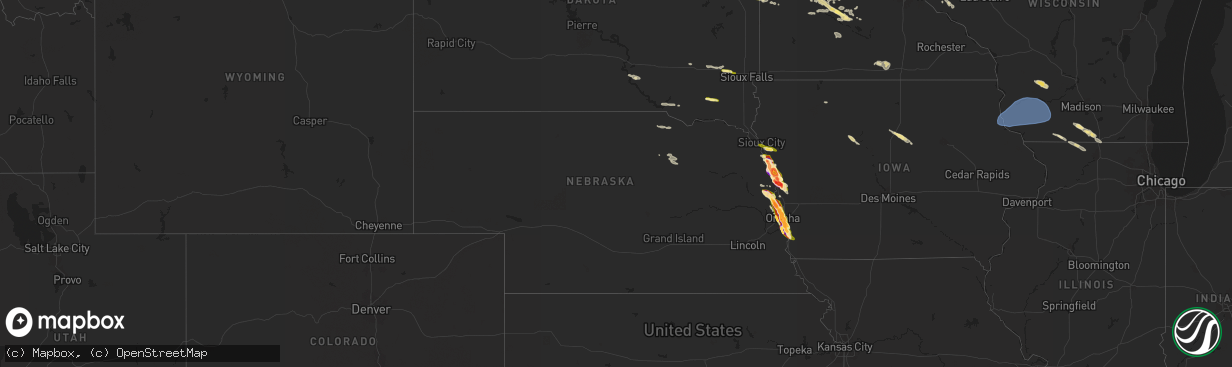
Hail Map in Nebraska on June 12, 2024
The weather event in Nebraska on June 12, 2024 includes Hail, Wind, and Tornado maps. 9 states and 417 cities were impacted and suffered possible damage. The total estimated number of properties impacted is 143,085.
Want more than just the map?
Turn this storm into a full workflow.
- Owner + property data so you know who to knock
- OnDemand branded weather history reports to win the "did we even have hail?" argument
- RoofTrace estimate so reps stop guessing numbers at the door
Bought this map? Upgrade within 7 days and we'll credit the $230. (10-15 min setup call)
Hail
Wind
Tornado
143,085
Estimated number of impacted properties by a 1.00" hail or larger130,041
Estimated number of impacted properties by a 1.75" hail or larger136,688
Estimated number of impacted properties by a 2.50" hail or largerStorm reports in Nebraska
Nebraska
| Date | Description |
|---|---|
| 06/12/20246:00 PM CDT | A local report indicates 1.25 inch wind near 1 SSE South Sioux City |
| 06/12/20245:58 PM CDT | A local report indicates 1.00 inch wind near South Sioux City |
| 06/11/20249:57 PM CDT | A local report indicates 1.75 inch wind near 1 NNW Plattsmouth |
| 06/11/20249:43 PM CDT | A local report indicates 1.25 inch wind near Offutt Afb |
| 06/11/20249:40 PM CDT | Picture from facebook. |
| 06/11/20249:34 PM CDT | Picture from facebook. |
| 06/11/20249:32 PM CDT | Picture from twitter. |
| 06/11/20249:25 PM CDT | Picture from facebook. |
| 06/11/20249:25 PM CDT | Approximately 2 inch diameter hail near bellevue university. |
| 06/11/20249:20 PM CDT | Picture from twitter. |
| 06/11/20249:20 PM CDT | Picture from twitter. |
| 06/11/20249:17 PM CDT | Golfball to baseball-size hail. |
| 06/11/20249:17 PM CDT | Office received several photos of hailstones ranging from 1 to 3 inches in diameter. |
| 06/11/20249:15 PM CDT | 45th and pine. |
| 06/11/20249:15 PM CDT | Picture from twitter. |
| 06/11/20249:15 PM CDT | University of nebraska at omaha. |
| 06/11/20249:13 PM CDT | Sporadic golf ball sized hail near 54th and seward. |
| 06/11/20249:11 PM CDT | A local report indicates 1.00 inch wind near 3 E Omaha |
| 06/11/20249:07 PM CDT | A local report indicates 2.00 inch wind near 3 E Omaha |
| 06/11/20249:05 PM CDT | North benson area. Picture via twitter. |
| 06/11/20249:02 PM CDT | Golf ball sized hail near benson high school. |
| 06/11/20249:00 PM CDT | From facebook. |
| 06/11/20248:59 PM CDT | A local report indicates 1.75 inch wind near 5 NNE Omaha |
| 06/11/20248:58 PM CDT | A local report indicates 1.50 inch wind near 6 NNE Omaha |
| 06/11/20248:57 PM CDT | A local report indicates 2.50 inch wind near 4 S Fort Calhoun |
| 06/11/20248:55 PM CDT | A local report indicates 1.50 inch wind near 2 NNE Omaha |
| 06/11/20248:50 PM CDT | A local report indicates 1.75 inch wind near 5 N Omaha |
| 06/11/20248:50 PM CDT | Lake cunningham. |
| 06/11/20248:46 PM CDT | Reported at north omaha airport. |
| 06/11/20248:42 PM CDT | Report from mping: golf ball |
| 06/11/20248:36 PM CDT | A local report indicates 2.00 inch wind near Blair |
| 06/11/20248:34 PM CDT | Report from mping: ping pong ball |
| 06/11/20248:33 PM CDT | Report from mping: tennis ball |
| 06/11/20248:27 PM CDT | Several 2 inch stones. Photo of one 3 inch stone. |
| 06/11/20248:18 PM CDT | A picture was sent to the office of 2 inch hail that had fallen in blair. |
| 06/11/20248:16 PM CDT | Report from mping: quarter |
| 06/11/20248:00 PM CDT | A local report indicates 1.00 inch wind near 2 W Herman |
| 06/11/20247:12 PM CDT | An ef-0 tornado developed just north of decatur... Breaking tree limbs and bringing down power lines. The tornado lasted approximately 1 minute according to eye-witness |
All States Impacted by Hail Map on June 12, 2024
Cities Impacted by Hail Map on June 12, 2024
- Webster, SD
- Waubay, SD
- Madison, MN
- Dawson, MN
- Goodwin, SD
- Summit, SD
- Wilmot, SD
- Marvin, SD
- Corona, SD
- Twin Brooks, SD
- Milbank, SD
- Montevideo, MN
- Maynard, MN
- Murdock, MN
- Clara City, MN
- Strandburg, SD
- Revillo, SD
- Gary, SD
- Clear Lake, SD
- Chamberlain, SD
- Platte, SD
- Marietta, MN
- Canby, MN
- Turton, SD
- Lake Andes, SD
- Chambers, NE
- Inman, NE
- Raymond, SD
- Clark, SD
- Wagner, SD
- Porter, MN
- Dupree, SD
- Spencer, NE
- Raymond, MN
- Ewing, NE
- Minneota, MN
- Taunton, MN
- Oneill, NE
- Lynch, NE
- Eagle Butte, SD
- Clearwater, NE
- Prinsburg, MN
- Blomkest, MN
- Renville, MN
- Lake Lillian, MN
- Redwood Falls, MN
- Morton, MN
- Olivia, MN
- Bird Island, MN
- Hector, MN
- Danube, MN
- Cosmos, MN
- Gibbon, MN
- Buffalo Lake, MN
- Willmar, MN
- Atwater, MN
- Stewart, MN
- Hutchinson, MN
- Menno, SD
- Vesta, MN
- Echo, MN
- Winthrop, MN
- Viborg, SD
- Irene, SD
- Sleepy Eye, MN
- Comfrey, MN
- Fairfax, MN
- Sacred Heart, MN
- New Ulm, MN
- Lafayette, MN
- Saint Peter, MN
- Gaylord, MN
- Mitchell, SD
- Brownton, MN
- Spencer, SD
- Salem, SD
- Minnesota Lake, MN
- Wells, MN
- Easton, MN
- Montrose, SD
- Alden, MN
- Canistota, SD
- Humboldt, SD
- Hartford, SD
- Minneapolis, MN
- Orr, MN
- Waubun, MN
- Ogema, MN
- Cassville, WI
- Garnavillo, IA
- Guttenberg, IA
- Glen Haven, WI
- Prairie Du Chien, WI
- Bagley, WI
- Mount Hope, WI
- Woodman, WI
- Wauzeka, WI
- Bloomington, WI
- Patch Grove, WI
- Lancaster, WI
- Blue River, WI
- Boscobel, WI
- Fennimore, WI
- Stitzer, WI
- Platteville, WI
- Crane Lake, MN
- Wahpeton, ND
- Campbell, MN
- Breckenridge, MN
- Ponsford, MN
- Bagley, MN
- Shevlin, MN
- Roswell, NM
- Park Rapids, MN
- Laporte, MN
- Naytahwaush, MN
- Solway, MN
- Lake George, MN
- Fergus Falls, MN
- Wendell, MN
- Fort Sumner, NM
- Cass Lake, MN
- Walker, MN
- Foxhome, MN
- Nashua, MN
- Bena, MN
- Cobb, WI
- Montfort, WI
- Highland, WI
- Livingston, WI
- Avoca, WI
- Muscoda, WI
- Rewey, WI
- Mineral Point, WI
- Spring Green, WI
- Dodgeville, WI
- Linden, WI
- Ely, MN
- Remer, MN
- Deer River, MN
- Cohasset, MN
- Grand Rapids, MN
- Longville, MN
- Akeley, MN
- Nevis, MN
- Elbow Lake, MN
- Ashby, MN
- Clarissa, MN
- Eagle Bend, MN
- Browerville, MN
- Long Prairie, MN
- Winton, MN
- Bovey, MN
- Pengilly, MN
- Nashwauk, MN
- Hibbing, MN
- Keewatin, MN
- Hope, NM
- Evansville, MN
- Barrett, MN
- Hackensack, MN
- Backus, MN
- Hill City, MN
- Brandon, MN
- Pine River, MN
- Chisholm, MN
- Mountain Iron, MN
- Farwell, MN
- Garfield, MN
- Alexandria, MN
- Kensington, MN
- Parkers Prairie, MN
- Miltona, MN
- Swatara, MN
- Hoffman, MN
- Carlos, MN
- Nelson, MN
- Osakis, MN
- Palisade, MN
- Pequot Lakes, MN
- Buhl, MN
- Kinney, MN
- Iron, MN
- Gilbert, MN
- Eveleth, MN
- Virginia, MN
- Homer, NE
- Winnebago, NE
- Sergeant Bluff, IA
- Sioux City, IA
- Jacobson, MN
- Goodland, MN
- Warba, MN
- Finland, MN
- Aurora, MN
- Biwabik, MN
- Embarrass, MN
- Hoyt Lakes, MN
- Crosslake, MN
- Mcgregor, MN
- Salix, IA
- Coleraine, MN
- Crosby, MN
- Fifty Lakes, MN
- Merrifield, MN
- Villard, MN
- Glenwood, MN
- Outing, MN
- Dalhart, TX
- Sloan, IA
- West Union, MN
- Emily, MN
- Aitkin, MN
- Deerwood, MN
- Sauk Centre, MN
- Hornick, IA
- Bronson, IA
- Carlsbad, NM
- Forbes, MN
- Tamarack, MN
- Whiting, IA
- Dickens, IA
- Side Lake, MN
- Dakota City, NE
- Onawa, IA
- Isabella, MN
- Babbitt, MN
- Cook, MN
- Wright, MN
- Melrose, MN
- Grey Eagle, MN
- Freeport, MN
- Britt, MN
- Big Stone City, SD
- Schroeder, MN
- Decatur, NE
- Macy, NE
- Tower, MN
- Cromwell, MN
- Albany, MN
- Moorhead, IA
- Blencoe, IA
- Herman, NE
- Craig, NE
- Avon, MN
- Artesia, NM
- Tekamah, NE
- Saint Joseph, MN
- Saint Stephen, MN
- Rice, MN
- Holdingford, MN
- Saint Cloud, MN
- Sartell, MN
- Sauk Rapids, MN
- Waite Park, MN
- Foley, MN
- Clear Lake, MN
- Blair, NE
- Arlington, NE
- Little Sioux, IA
- Pisgah, IA
- Neche, ND
- Walhalla, ND
- Wrenshall, MN
- Fort Calhoun, NE
- Hamilton, ND
- Bathgate, ND
- Makinen, MN
- Willow River, MN
- McGrath, MN
- Sturgeon Lake, MN
- Finlayson, MN
- Manson, IA
- Palmer, IA
- Oakland, NE
- Drayton, ND
- Pembina, ND
- Hallock, MN
- Isle, MN
- Mondamin, IA
- Clare, IA
- Barnum, IA
- Woodbine, IA
- Askov, MN
- Salt Flat, TX
- Kennedy, MN
- Sandstone, MN
- Becker, MN
- Omaha, NE
- Princeton, MN
- Bruno, MN
- Albert Lea, MN
- Logan, IA
- Kennard, NE
- Fort Dodge, IA
- Crescent, IA
- Magnolia, IA
- Bennington, NE
- Missouri Valley, IA
- Mahnomen, MN
- Moorland, IA
- Carter Lake, IA
- Council Bluffs, IA
- Bellevue, NE
- Isanti, MN
- Zimmerman, MN
- Hayward, WI
- Hinckley, MN
- Elk River, MN
- Big Lake, MN
- Modale, IA
- Stanchfield, MN
- Offutt Afb, NE
- Pacific Junction, IA
- Anoka, MN
- Cedar, MN
- Saint Francis, MN
- Papillion, NE
- La Vista, NE
- Glenwood, IA
- Plattsmouth, NE
- Bethel, MN
- Andover, MN
- Buffalo, MN
- Maple Lake, MN
- Annandale, MN
- Tabor, IA
- Albertville, MN
- Saint Michael, MN
- Monticello, MN
- Stacy, MN
- Circle Pines, MN
- Wyoming, MN
- Galt, IA
- Calumet, MN
- Dows, IA
- Alden, IA
- Forest Lake, MN
- Saint Paul, MN
- Inver Grove Heights, MN
- Iowa Falls, IA
- River Falls, WI
- Franklin, MN
- Odessa, MN
- Ortonville, MN
- Hammond, WI
- Baldwin, WI
- Cottage Grove, MN
- Afton, MN
- Waverly, MN
- Howard Lake, MN
- Mayer, MN
- Montrose, MN
- Watertown, MN
- Winsted, MN
- Ackley, IA
- Lake Elmo, MN
- Stillwater, MN
- Willernie, MN
- New Germany, MN
- Hastings, MN
- Waconia, MN
- Roberts, WI
- Hudson, WI
- Lakeland, MN
- South Sioux City, NE
- Beldenville, WI
- Spring Valley, WI
- Ellsworth, WI
- Hugo, MN
- Elmwood, WI
- Marcell, MN
- South Saint Paul, MN
- Newport, MN
- Saint Paul Park, MN
- Belview, MN
- Maiden Rock, WI
- Plum City, WI
- Osage, MN
- Carlton, MN
- Bemidji, MN
- Minong, WI
- Moose Lake, MN
- Bayport, MN
- Solon Springs, WI
- Ruthven, IA
- Steamboat Rock, IA
- Latimer, IA
- Alexander, IA
- Cazenovia, WI
- Hillsboro, WI
- Richland Center, WI
- Hillpoint, WI
- La Valle, WI
- South Wayne, WI
- Gratiot, WI
- Brooklyn, WI
- Albany, WI
- Monticello, WI
- Belleville, WI
- Browntown, WI
- Evansville, WI
- Monroe, WI
- Orangeville, IL
- Brodhead, WI
- Janesville, WI
- Footville, WI
- Orfordville, WI
- Beloit, WI
- Rock City, IL
- Dakota, IL
- Davis, IL
- Durand, IL
- Pecatonica, IL
- Afton, WI
- Clinton, WI
- South Beloit, IL


