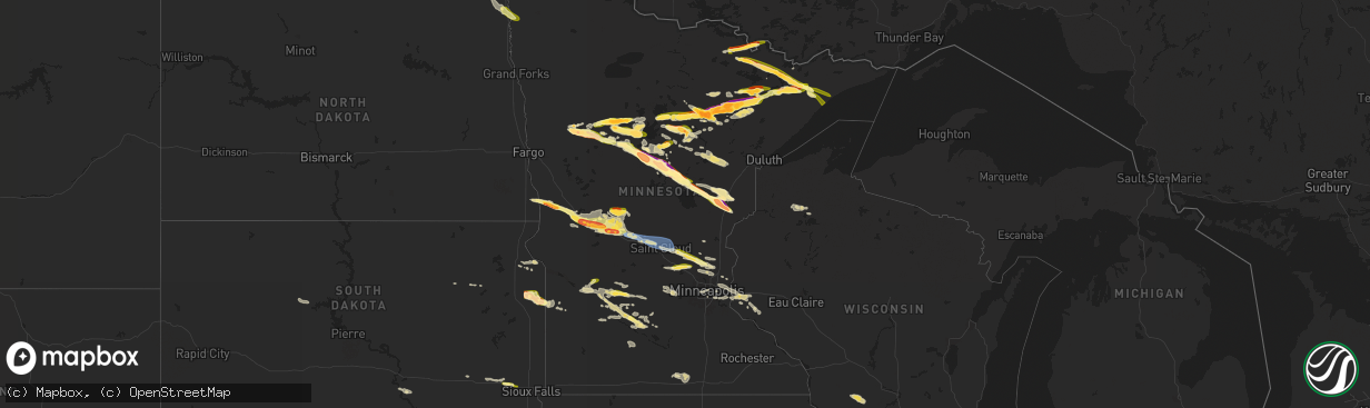
Hail Map in Minnesota on June 12, 2024
The weather event in Minnesota on June 12, 2024 includes Hail, Wind, and Tornado maps. 9 states and 417 cities were impacted and suffered possible damage. The total estimated number of properties impacted is 101,952.
Want more than just the map?
Turn this storm into a full workflow.
- Owner + property data so you know who to knock
- OnDemand branded weather history reports to win the "did we even have hail?" argument
- RoofTrace estimate so reps stop guessing numbers at the door
Bought this map? Upgrade within 7 days and we'll credit the $230. (10-15 min setup call)
Hail
Wind
Tornado
101,952
Estimated number of impacted properties by a 1.00" hail or larger35,201
Estimated number of impacted properties by a 1.75" hail or larger9,271
Estimated number of impacted properties by a 2.50" hail or largerStorm reports in Minnesota
Minnesota
| Date | Description |
|---|---|
| 06/12/20246:59 PM CDT | A local report indicates 1.50 inch wind near 12 WNW Isabella |
| 06/12/20246:56 PM CDT | Tornado crossed mn 210. Softwood trees snapped. Time estimated from radar. Preliminary rating ef-1. |
| 06/12/20246:54 PM CDT | End of the wright/cromwell tornado. |
| 06/12/20246:54 PM CDT | With photo. Large trees snapped and uprooted. Time estimated. |
| 06/12/20246:48 PM CDT | With photos. Numerous trees snapped. Time estimated. |
| 06/12/20246:48 PM CDT | With photo. Extensive tree damage. Medium to large trees snapped. Trailer home turned over. Time estimated from radar. |
| 06/12/20246:47 PM CDT | Tornado crossed mn 6. Numerous softwood trees broken and uprooted. Time estimated from radar. Preliminary rating ef-1. |
| 06/12/20246:47 PM CDT | Preliminary information. Tornado crossed center road. Time estimated from radar. Ef-tbd. |
| 06/12/20246:44 PM CDT | Softwood trees uprooted. Time estimated from radar. Preliminary rating ef-1. |
| 06/12/20246:43 PM CDT | 3 large trees uprooted. |
| 06/12/20246:42 PM CDT | Start of the wright/cromwell tornado. |
| 06/12/20246:42 PM CDT | Softwood trees uprooted. Time estimated from radar. Preliminary ef-1. |
| 06/12/20246:42 PM CDT | Preliminary information. Tornado crossed west road. Time estimated from radar. Ef-tbd. |
| 06/12/20246:41 PM CDT | Time estimated from radar. Max wind gust to 53 mph also measured. |
| 06/12/20246:39 PM CDT | A local report indicates 1.00 inch wind near 3 ESE Iron Junction |
| 06/12/20246:31 PM CDT | A local report indicates 1.75 inch wind near 1 NE Lake Shore |
| 06/12/20246:30 PM CDT | Several trees uprooted and snapped. |
| 06/12/20246:30 PM CDT | Small to medium trees snapped. With photo. |
| 06/12/20246:30 PM CDT | Report from mping: ping pong ball |
| 06/12/20246:26 PM CDT | Photo/video from social media. Numerous trees down. Boat lift and dock destroyed. Time estimated. |
| 06/12/20246:25 PM CDT | Reports heavy damage. Powerlines down across road... Damage to siding and roofs... And numerous trees down. Time estimated. |
| 06/12/20246:23 PM CDT | End of the whitefish lake/clamshell lake tornado. |
| 06/12/20246:23 PM CDT | A local report indicates 1.50 inch wind near 3 SW Crosslake |
| 06/12/20246:22 PM CDT | Report from mping half dollar |
| 06/12/20246:21 PM CDT | Preliminary information. Softwood tree trunks snapped. Time estimated from radar. Ef-tbd. |
| 06/12/20246:20 PM CDT | Preliminary information. Softwood tree trunks snapped. Time estimated from radar. Ef-tbd. |
| 06/12/20246:20 PM CDT | Preliminary information. Tornado crossed ruttger road. Softwood tree trunks snapped. Numerous large trees uprooted. Damage to numerous homes. Time estimated from radar. |
| 06/12/20246:19 PM CDT | Report from mping: hen egg |
| 06/12/20246:18 PM CDT | Start of the whitefish lake/clamshell lake tornado. |
| 06/12/20246:18 PM CDT | A local report indicates 1.00 inch wind near Virginia |
| 06/12/20246:17 PM CDT | Picture of hail about 1.5 inches in diameter. Reported 2 inches or more in diameter falling continually between 617 pm and 642 pm a half mile south of crosslakes pine r |
| 06/12/20246:15 PM CDT | Multiple trees snapped in the crosslake recreation area. One healthy looking tree that looked to be 1 to 2 ft in diameter that was snapped near the base was included. |
| 06/12/20246:15 PM CDT | Photos received showing baseball sized hail along with a broken windshield from the hail. |
| 06/12/20246:13 PM CDT | A local report indicates 1.25 inch wind near Biwabik |
| 06/12/20246:13 PM CDT | Report from mping: tennis ball |
| 06/12/20246:13 PM CDT | Report from mping quarter |
| 06/12/20246:12 PM CDT | With photos. Several small to medium trees down... Snapped near base. |
| 06/12/20246:10 PM CDT | A local report indicates 1.25 inch wind near 1 SW Alexandria |
| 06/12/20246:10 PM CDT | Hail lasted about 20 minutes. |
| 06/12/20246:09 PM CDT | Damage to roof and car. |
| 06/12/20246:07 PM CDT | A local report indicates 1.00 inch wind near 3 W Nelson |
| 06/12/20246:06 PM CDT | A local report indicates 1.75 inch wind near 1 NNW Chisholm |
| 06/12/20246:05 PM CDT | Lots of hail coming down. |
| 06/12/20246:04 PM CDT | A local report indicates 1.00 inch wind near 1 SW Alexandria |
| 06/12/20246:04 PM CDT | Report from mping quarter |
| 06/12/20246:04 PM CDT | Hail on going. |
| 06/12/20246:04 PM CDT | A local report indicates 1.13 inch wind near Alexandria |
| 06/12/20246:02 PM CDT | Report from mping quarter |
| 06/12/20246:00 PM CDT | A local report indicates 1.00 inch wind near 3 W Leonidas |
| 06/12/20246:00 PM CDT | A local report indicates 1.75 inch wind near 3 NW Jenkins |
| 06/12/20245:59 PM CDT | Corrects previous hail report from 12 wnw isabella. |
| 06/12/20245:58 PM CDT | A local report indicates 2.50 inch wind near 2 N Backus |
| 06/12/20245:56 PM CDT | A local report indicates 1.50 inch wind near Buhl |
| 06/12/20245:55 PM CDT | A local report indicates 1.25 inch wind near 7 NNW Bovey |
| 06/12/20245:54 PM CDT | A local report indicates 1.00 inch wind near Chisholm |
| 06/12/20245:54 PM CDT | A local report indicates 1.75 inch wind near 1 SW Chisholm |
| 06/12/20245:53 PM CDT | Delayed report. Holes in gutters and dents in car suggest 3 hail may have occurred. |
| 06/12/20245:53 PM CDT | A local report indicates 1.75 inch wind near 1 N Backus |
| 06/12/20245:53 PM CDT | Report from mping: golf ball |
| 06/12/20245:51 PM CDT | Report from mping: half dollar |
| 06/12/20245:50 PM CDT | Report from mping: hen egg |
| 06/12/20245:50 PM CDT | 2.25 inch hail in chisholm. Location approximate. Report received via facebook. |
| 06/12/20245:50 PM CDT | A local report indicates 2.50 inch wind near Chisholm |
| 06/12/20245:49 PM CDT | Report from mping: half dollar |
| 06/12/20245:49 PM CDT | Photo of quarter sized hail in nevis city limits. |
| 06/12/20245:47 PM CDT | A local report indicates 2.00 inch wind near 1 S Backus |
| 06/12/20245:46 PM CDT | Time estimated from radar. Size estimated from photo. |
| 06/12/20245:46 PM CDT | A local report indicates 2.00 inch wind near 3 NNW Kelly Lake |
| 06/12/20245:46 PM CDT | Hail size estimated from social media photo. Vehicles damaged. |
| 06/12/20245:45 PM CDT | Car window broken from hail. |
| 06/12/20245:45 PM CDT | Report with photo. |
| 06/12/20245:44 PM CDT | A local report indicates 1.75 inch wind near 8 SSW Cohasset |
| 06/12/20245:41 PM CDT | Public relays photo of half dollar sized hail via social media. |
| 06/12/20245:40 PM CDT | A local report indicates 1.25 inch wind near 6 SSW Grand Rapids |
| 06/12/20245:40 PM CDT | Via social media with photo. |
| 06/12/20245:40 PM CDT | Entire backyard jungle gym picked up and turned over. Time estimated. |
| 06/12/20245:35 PM CDT | Report from mping. |
| 06/12/20245:32 PM CDT | Delayed report of golfball size hail. Time estimated from radar. |
| 06/12/20245:31 PM CDT | A local report indicates 1.25 inch wind near 7 NNW Bovey |
| 06/12/20245:30 PM CDT | Public reported 2.0 inch hail in schoolcraft... Mn via fb. |
| 06/12/20245:26 PM CDT | A local report indicates 1.50 inch wind near 1 SSW Winton |
| 06/12/20245:25 PM CDT | A local report indicates 1.00 inch wind near 4 WSW Clarissa |
| 06/12/20245:20 PM CDT | A local report indicates 1.75 inch wind near 7 NNW Taconite |
| 06/12/20245:20 PM CDT | Social media reports of hail in and to the northwest of walker towards benedict. Time estimated from radar with account of hail before 5:30 pm. |
| 06/12/20245:20 PM CDT | No damage other than small tree branches knocked off trees. |
| 06/12/20245:18 PM CDT | A local report indicates 1.00 inch wind near 3 E Nevis |
| 06/12/20245:17 PM CDT | Damage to boat lift. 6 to 10 inch diameter trees down. |
| 06/12/20245:15 PM CDT | Report from mping. |
| 06/12/20245:13 PM CDT | Report from mping: quarter |
| 06/12/20245:12 PM CDT | A local report indicates 1.75 inch wind near 1 NNE Ely |
| 06/12/20245:10 PM CDT | Quarter size hail on echo trail north of ely. Time estimated from radar. |
| 06/12/20245:09 PM CDT | A local report indicates 1.50 inch wind near Deer River |
| 06/12/20245:09 PM CDT | A local report indicates 1.50 inch wind near 1 SE Inguadona |
| 06/12/20244:50 PM CDT | Combination of quarter sized hail and strong winds striped and destroyed cornfields. Time estimated from radar. |
| 06/12/20244:46 PM CDT | A local report indicates 1.50 inch wind near 3 E Bena |
| 06/12/20244:45 PM CDT | Ping pong ball sized hail 10 miles south of bemidji. |
| 06/12/20244:30 PM CDT | Photo of quarter sized hail relayed by broadcast media. |
| 06/12/20244:25 PM CDT | Report via social media with photo. |
| 06/12/20244:20 PM CDT | Public reported ping pong ball sized hail on crane lake with a severe thunderstorm. Time estimated based on radar. |
| 06/12/20244:18 PM CDT | Public report of ping pong ball sized hail. Time estimated based on radar. |
| 06/12/20244:10 PM CDT | Public reports golf ball size hail in white earth mn at 410pm. |
| 06/12/20244:08 PM CDT | Public report of estimated quarter size hail. Time estimated based on time of report and radar. |
| 06/12/20241:00 PM CDT | Photo of downed tree in twin lakes. Time was estimated. |
| 06/12/202411:14 AM CDT | Report of 4 power line poles that were damaged... Which took down power to substations... Resulting in a brief power outage. |
| 06/12/20249:45 AM CDT | Report of half dollar size hail from concorde bank. |
| 06/12/20241:28 AM CDT | Report of half dollar to ping pong ball size hail in north nashwauk. Location approximate. Time estimated by radar. Report received via facebook. |
| 06/12/202412:11 AM CDT | Corrected punctuation and grammar. 7 trees down. One tree uprooted fell on a porch. One tree split near bottom fell on a garage. 5 others fell scattered on the property |
| 06/12/202412:02 AM CDT | Delayed report. 3-4 ft diameter tree uprooted... And numerous large branches snapped... About 8-12 diameter. Time estimated via radar. |
| 06/11/202411:17 PM CDT | Report from mping: quarter |
| 06/11/202411:11 PM CDT | Report from mping: quarter |
| 06/11/202410:14 PM CDT | A local report indicates 1.25 inch wind near Big Lake |
| 06/11/20249:49 PM CDT | Report from mping: quarter |
| 06/11/20249:20 PM CDT | Reported 2 miles west of the intersection of hwy 47 and county rd 28. |
| 06/11/20249:06 PM CDT | Report from mping hen egg+ |
| 06/11/20249:05 PM CDT | A local report indicates 1.00 inch wind near Zimmerman |
| 06/11/20248:57 PM CDT | Report from mping ping pong ball |
| 06/11/20248:55 PM CDT | Mn hwy 7 mile post 11 rwis. |
| 06/11/20248:55 PM CDT | A local report indicates 1.75 inch wind near 1 SSE Sandstone |
| 06/11/20248:55 PM CDT | Mn hwy 7 mile post 11 rwis...also reports of trees snappednear the sensor location. Corrected to report the measured gust of 78mph not 68mph. |
| 06/11/20248:53 PM CDT | Photo received of a hailstone with a ruler. Tennis ball sized hail with many more 2 inches in diameter. |
| 06/11/20248:50 PM CDT | Corrects previous hail report from 2 e friesland. Report from mping hen egg+ |
| 06/11/20248:42 PM CDT | A local report indicates 1.25 inch wind near 5 W Finlayson |
| 06/11/20248:39 PM CDT | Photo received showing two pieces of golf ball sized hail. |
| 06/11/20248:05 PM CDT | Hail with some as big around as a quarter and some smaller. Location about 400 yards south of the intersection of county road 12 and state highway 47. Location approxim |
| 06/11/20247:40 PM CDT | Tree damage. Reported via mping. |
| 06/11/20247:40 PM CDT | Downed tree was reported via x. Photo included. Time was estimated. |
| 06/11/20247:30 PM CDT | Large branches down and power out in sartell. Reported via x. Time was estimated. |
| 06/11/20247:29 PM CDT | A local report indicates 61 MPH wind near 2 SW Sartell |
| 06/11/20247:28 PM CDT | Storm chaser video of a weak and wispy tornado east of mn 47. Location approximate based on video. |
| 06/11/20247:20 PM CDT | Started as dime to nickel size hail and increased to quarters. |
| 06/11/20247:19 PM CDT | Tree with diameter at least 18 inches down blocking lane of highway 210. Time is when damage was reported. |
| 06/11/20247:18 PM CDT | Delayed report. Many trees down. Time estimated from radar. |
| 06/11/20247:10 PM CDT | Numerous hail stones... Enough to fill up a bucket. |
| 06/11/20247:08 PM CDT | Report from mping: quarter |
| 06/11/20247:06 PM CDT | A local report indicates 1.25 inch wind near Aitkin |
| 06/11/20247:05 PM CDT | A local report indicates 1.75 inch wind near 5 W Aitkin |
| 06/11/20247:05 PM CDT | End of rabbit lake to cedar lake/hammal lake tornado. |
| 06/11/20247:05 PM CDT | 50 foot tall trees uprooted. |
| 06/11/20247:00 PM CDT | Narrow swath of significant tree damage. Softwood trees snapped. Time estimated from radar. Preliminary rating ef-1. |
All States Impacted by Hail Map on June 12, 2024
Cities Impacted by Hail Map on June 12, 2024
- Webster, SD
- Waubay, SD
- Madison, MN
- Dawson, MN
- Goodwin, SD
- Summit, SD
- Wilmot, SD
- Marvin, SD
- Corona, SD
- Twin Brooks, SD
- Milbank, SD
- Montevideo, MN
- Maynard, MN
- Murdock, MN
- Clara City, MN
- Strandburg, SD
- Revillo, SD
- Gary, SD
- Clear Lake, SD
- Chamberlain, SD
- Platte, SD
- Marietta, MN
- Canby, MN
- Turton, SD
- Lake Andes, SD
- Chambers, NE
- Inman, NE
- Raymond, SD
- Clark, SD
- Wagner, SD
- Porter, MN
- Dupree, SD
- Spencer, NE
- Raymond, MN
- Ewing, NE
- Minneota, MN
- Taunton, MN
- Oneill, NE
- Lynch, NE
- Eagle Butte, SD
- Clearwater, NE
- Prinsburg, MN
- Blomkest, MN
- Renville, MN
- Lake Lillian, MN
- Redwood Falls, MN
- Morton, MN
- Olivia, MN
- Bird Island, MN
- Hector, MN
- Danube, MN
- Cosmos, MN
- Gibbon, MN
- Buffalo Lake, MN
- Willmar, MN
- Atwater, MN
- Stewart, MN
- Hutchinson, MN
- Menno, SD
- Vesta, MN
- Echo, MN
- Winthrop, MN
- Viborg, SD
- Irene, SD
- Sleepy Eye, MN
- Comfrey, MN
- Fairfax, MN
- Sacred Heart, MN
- New Ulm, MN
- Lafayette, MN
- Saint Peter, MN
- Gaylord, MN
- Mitchell, SD
- Brownton, MN
- Spencer, SD
- Salem, SD
- Minnesota Lake, MN
- Wells, MN
- Easton, MN
- Montrose, SD
- Alden, MN
- Canistota, SD
- Humboldt, SD
- Hartford, SD
- Minneapolis, MN
- Orr, MN
- Waubun, MN
- Ogema, MN
- Cassville, WI
- Garnavillo, IA
- Guttenberg, IA
- Glen Haven, WI
- Prairie Du Chien, WI
- Bagley, WI
- Mount Hope, WI
- Woodman, WI
- Wauzeka, WI
- Bloomington, WI
- Patch Grove, WI
- Lancaster, WI
- Blue River, WI
- Boscobel, WI
- Fennimore, WI
- Stitzer, WI
- Platteville, WI
- Crane Lake, MN
- Wahpeton, ND
- Campbell, MN
- Breckenridge, MN
- Ponsford, MN
- Bagley, MN
- Shevlin, MN
- Roswell, NM
- Park Rapids, MN
- Laporte, MN
- Naytahwaush, MN
- Solway, MN
- Lake George, MN
- Fergus Falls, MN
- Wendell, MN
- Fort Sumner, NM
- Cass Lake, MN
- Walker, MN
- Foxhome, MN
- Nashua, MN
- Bena, MN
- Cobb, WI
- Montfort, WI
- Highland, WI
- Livingston, WI
- Avoca, WI
- Muscoda, WI
- Rewey, WI
- Mineral Point, WI
- Spring Green, WI
- Dodgeville, WI
- Linden, WI
- Ely, MN
- Remer, MN
- Deer River, MN
- Cohasset, MN
- Grand Rapids, MN
- Longville, MN
- Akeley, MN
- Nevis, MN
- Elbow Lake, MN
- Ashby, MN
- Clarissa, MN
- Eagle Bend, MN
- Browerville, MN
- Long Prairie, MN
- Winton, MN
- Bovey, MN
- Pengilly, MN
- Nashwauk, MN
- Hibbing, MN
- Keewatin, MN
- Hope, NM
- Evansville, MN
- Barrett, MN
- Hackensack, MN
- Backus, MN
- Hill City, MN
- Brandon, MN
- Pine River, MN
- Chisholm, MN
- Mountain Iron, MN
- Farwell, MN
- Garfield, MN
- Alexandria, MN
- Kensington, MN
- Parkers Prairie, MN
- Miltona, MN
- Swatara, MN
- Hoffman, MN
- Carlos, MN
- Nelson, MN
- Osakis, MN
- Palisade, MN
- Pequot Lakes, MN
- Buhl, MN
- Kinney, MN
- Iron, MN
- Gilbert, MN
- Eveleth, MN
- Virginia, MN
- Homer, NE
- Winnebago, NE
- Sergeant Bluff, IA
- Sioux City, IA
- Jacobson, MN
- Goodland, MN
- Warba, MN
- Finland, MN
- Aurora, MN
- Biwabik, MN
- Embarrass, MN
- Hoyt Lakes, MN
- Crosslake, MN
- Mcgregor, MN
- Salix, IA
- Coleraine, MN
- Crosby, MN
- Fifty Lakes, MN
- Merrifield, MN
- Villard, MN
- Glenwood, MN
- Outing, MN
- Dalhart, TX
- Sloan, IA
- West Union, MN
- Emily, MN
- Aitkin, MN
- Deerwood, MN
- Sauk Centre, MN
- Hornick, IA
- Bronson, IA
- Carlsbad, NM
- Forbes, MN
- Tamarack, MN
- Whiting, IA
- Dickens, IA
- Side Lake, MN
- Dakota City, NE
- Onawa, IA
- Isabella, MN
- Babbitt, MN
- Cook, MN
- Wright, MN
- Melrose, MN
- Grey Eagle, MN
- Freeport, MN
- Britt, MN
- Big Stone City, SD
- Schroeder, MN
- Decatur, NE
- Macy, NE
- Tower, MN
- Cromwell, MN
- Albany, MN
- Moorhead, IA
- Blencoe, IA
- Herman, NE
- Craig, NE
- Avon, MN
- Artesia, NM
- Tekamah, NE
- Saint Joseph, MN
- Saint Stephen, MN
- Rice, MN
- Holdingford, MN
- Saint Cloud, MN
- Sartell, MN
- Sauk Rapids, MN
- Waite Park, MN
- Foley, MN
- Clear Lake, MN
- Blair, NE
- Arlington, NE
- Little Sioux, IA
- Pisgah, IA
- Neche, ND
- Walhalla, ND
- Wrenshall, MN
- Fort Calhoun, NE
- Hamilton, ND
- Bathgate, ND
- Makinen, MN
- Willow River, MN
- McGrath, MN
- Sturgeon Lake, MN
- Finlayson, MN
- Manson, IA
- Palmer, IA
- Oakland, NE
- Drayton, ND
- Pembina, ND
- Hallock, MN
- Isle, MN
- Mondamin, IA
- Clare, IA
- Barnum, IA
- Woodbine, IA
- Askov, MN
- Salt Flat, TX
- Kennedy, MN
- Sandstone, MN
- Becker, MN
- Omaha, NE
- Princeton, MN
- Bruno, MN
- Albert Lea, MN
- Logan, IA
- Kennard, NE
- Fort Dodge, IA
- Crescent, IA
- Magnolia, IA
- Bennington, NE
- Missouri Valley, IA
- Mahnomen, MN
- Moorland, IA
- Carter Lake, IA
- Council Bluffs, IA
- Bellevue, NE
- Isanti, MN
- Zimmerman, MN
- Hayward, WI
- Hinckley, MN
- Elk River, MN
- Big Lake, MN
- Modale, IA
- Stanchfield, MN
- Offutt Afb, NE
- Pacific Junction, IA
- Anoka, MN
- Cedar, MN
- Saint Francis, MN
- Papillion, NE
- La Vista, NE
- Glenwood, IA
- Plattsmouth, NE
- Bethel, MN
- Andover, MN
- Buffalo, MN
- Maple Lake, MN
- Annandale, MN
- Tabor, IA
- Albertville, MN
- Saint Michael, MN
- Monticello, MN
- Stacy, MN
- Circle Pines, MN
- Wyoming, MN
- Galt, IA
- Calumet, MN
- Dows, IA
- Alden, IA
- Forest Lake, MN
- Saint Paul, MN
- Inver Grove Heights, MN
- Iowa Falls, IA
- River Falls, WI
- Franklin, MN
- Odessa, MN
- Ortonville, MN
- Hammond, WI
- Baldwin, WI
- Cottage Grove, MN
- Afton, MN
- Waverly, MN
- Howard Lake, MN
- Mayer, MN
- Montrose, MN
- Watertown, MN
- Winsted, MN
- Ackley, IA
- Lake Elmo, MN
- Stillwater, MN
- Willernie, MN
- New Germany, MN
- Hastings, MN
- Waconia, MN
- Roberts, WI
- Hudson, WI
- Lakeland, MN
- South Sioux City, NE
- Beldenville, WI
- Spring Valley, WI
- Ellsworth, WI
- Hugo, MN
- Elmwood, WI
- Marcell, MN
- South Saint Paul, MN
- Newport, MN
- Saint Paul Park, MN
- Belview, MN
- Maiden Rock, WI
- Plum City, WI
- Osage, MN
- Carlton, MN
- Bemidji, MN
- Minong, WI
- Moose Lake, MN
- Bayport, MN
- Solon Springs, WI
- Ruthven, IA
- Steamboat Rock, IA
- Latimer, IA
- Alexander, IA
- Cazenovia, WI
- Hillsboro, WI
- Richland Center, WI
- Hillpoint, WI
- La Valle, WI
- South Wayne, WI
- Gratiot, WI
- Brooklyn, WI
- Albany, WI
- Monticello, WI
- Belleville, WI
- Browntown, WI
- Evansville, WI
- Monroe, WI
- Orangeville, IL
- Brodhead, WI
- Janesville, WI
- Footville, WI
- Orfordville, WI
- Beloit, WI
- Rock City, IL
- Dakota, IL
- Davis, IL
- Durand, IL
- Pecatonica, IL
- Afton, WI
- Clinton, WI
- South Beloit, IL


