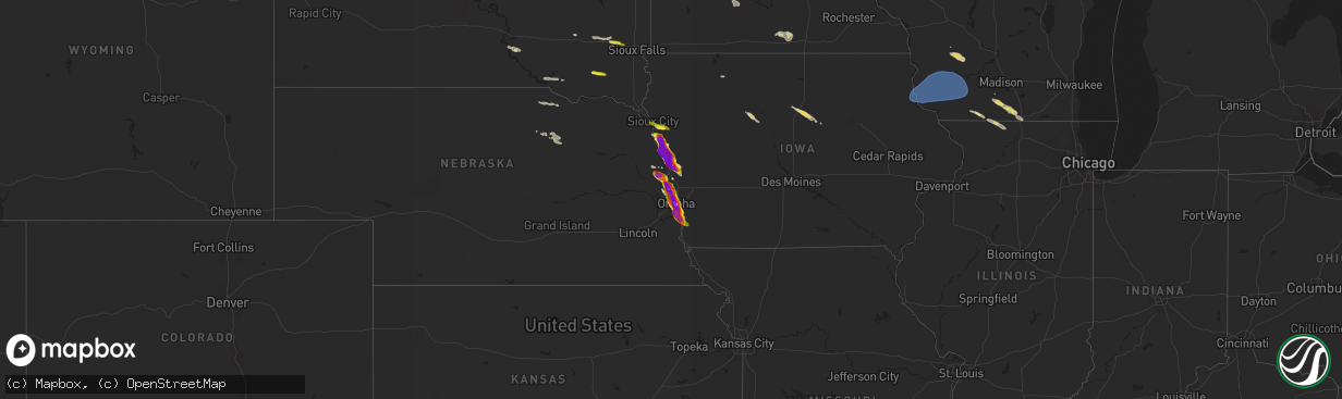
Hail Map on June 12, 2024
The weather event on June 12, 2024 includes Hail, Wind, and Tornado maps. 9 states and 417 cities were impacted and suffered possible damage. The total estimated number of properties impacted is 274,280.
Want more than just the map?
Turn this storm into a full workflow.
- Owner + property data so you know who to knock
- OnDemand branded weather history reports to win the "did we even have hail?" argument
- RoofTrace estimate so reps stop guessing numbers at the door
Bought this map? Upgrade within 7 days and we'll credit the $230. (10-15 min setup call)
Hail
Wind
Tornado
274,280
Estimated number of impacted properties by a 1.00" hail or larger182,562
Estimated number of impacted properties by a 1.75" hail or larger153,324
Estimated number of impacted properties by a 2.50" hail or largerStates Impacted by Hail Map on June 12, 2024
Storm reports
Wisconsin
| Date | Description |
|---|---|
| 06/12/20246:05 PM CDT | Picture of tree down on evansville/brooklynn road from social media |
| 06/12/20245:35 PM CDT | Numerous reports of tree limbs down in middleton. At 535 pm cdt... Middleton airport awos measured gusts to 49 mph. |
| 06/12/20245:00 PM CDT | Iowa county emergency management reported a tree down on adams hill rd. |
| 06/12/20244:55 PM CDT | Several trees down and power line damage reported in dodgeville by emergency managers. |
| 06/12/20244:55 PM CDT | Iowa county em estimates 60 mph wind damage in dodgeville... Wi. |
| 06/12/20244:41 PM CDT | Report of tree down on county road n from iowa county emergency management. |
| 06/12/20244:35 PM CDT | Tree branches down. |
| 06/12/20244:22 PM CDT | Trees down on power lines in the lancaster and boscobel areas. |
| 06/12/20244:11 PM CDT | Report from mping: 3-inch tree limbs broken; power poles broken. |
| 06/12/20244:07 PM CDT | Asos station kovs boscobel airport. |
| 06/12/20243:54 PM CDT | A few trees down around glen haven and bagley. Fire department estimated 60 to 70 mph winds. |
| 06/12/20246:28 AM CDT | Rock co. Emergency management relayed report of multiple trees down at the intersection of hwy-67 and s maxworthy rd. Time estimated based on radar. |
| 06/11/202411:41 PM CDT | Report from mping: quarter |
| 06/11/202411:38 PM CDT | Report from mping: quarter |
| 06/11/202411:02 PM CDT | Public report of a tree falling on a car in amery. Passed along by broadcast media. |
North Dakota
| Date | Description |
|---|---|
| 06/11/20247:55 PM CDT | Multiple trees damaged in a shelter belt. Time estimated. |
New Mexico
| Date | Description |
|---|---|
| 06/12/20245:45 PM CDT | A local report indicates 1.50 inch wind near Hope |
| 06/11/20247:25 PM CDT | Asos station kcnm carlsbad. A dust storm with visibility of one quarter mile or less was observed also. |
South Dakota
| Date | Description |
|---|---|
| 06/12/202412:58 PM CDT | Corrects previous hail report from 4 ne canistota. Spotter reported 1 inch hail. |
| 06/12/202412:55 PM CDT | Spotter reported 1 inch hail. |
| 06/12/202412:50 PM CDT | Mccook county em called to report trees down in salem. He also reported heavy rain with some ponding due to drainage issues but that it has already subsided. He also re |
| 06/12/20247:33 AM CDT | A local report indicates 1.00 inch wind near 1 NW Gary |
| 06/12/20247:25 AM CDT | A local report indicates 1.00 inch wind near 4 S Revillo |
Minnesota
| Date | Description |
|---|---|
| 06/12/20246:59 PM CDT | A local report indicates 1.50 inch wind near 12 WNW Isabella |
| 06/12/20246:56 PM CDT | Tornado crossed mn 210. Softwood trees snapped. Time estimated from radar. Preliminary rating ef-1. |
| 06/12/20246:54 PM CDT | End of the wright/cromwell tornado. |
| 06/12/20246:54 PM CDT | With photo. Large trees snapped and uprooted. Time estimated. |
| 06/12/20246:48 PM CDT | With photos. Numerous trees snapped. Time estimated. |
| 06/12/20246:48 PM CDT | With photo. Extensive tree damage. Medium to large trees snapped. Trailer home turned over. Time estimated from radar. |
| 06/12/20246:47 PM CDT | Tornado crossed mn 6. Numerous softwood trees broken and uprooted. Time estimated from radar. Preliminary rating ef-1. |
| 06/12/20246:47 PM CDT | Preliminary information. Tornado crossed center road. Time estimated from radar. Ef-tbd. |
| 06/12/20246:44 PM CDT | Softwood trees uprooted. Time estimated from radar. Preliminary rating ef-1. |
| 06/12/20246:43 PM CDT | 3 large trees uprooted. |
| 06/12/20246:42 PM CDT | Softwood trees uprooted. Time estimated from radar. Preliminary ef-1. |
| 06/12/20246:42 PM CDT | Preliminary information. Tornado crossed west road. Time estimated from radar. Ef-tbd. |
| 06/12/20246:42 PM CDT | Start of the wright/cromwell tornado. |
| 06/12/20246:41 PM CDT | Time estimated from radar. Max wind gust to 53 mph also measured. |
| 06/12/20246:39 PM CDT | A local report indicates 1.00 inch wind near 3 ESE Iron Junction |
| 06/12/20246:31 PM CDT | A local report indicates 1.75 inch wind near 1 NE Lake Shore |
| 06/12/20246:30 PM CDT | Report from mping: ping pong ball |
| 06/12/20246:30 PM CDT | Several trees uprooted and snapped. |
| 06/12/20246:30 PM CDT | Small to medium trees snapped. With photo. |
| 06/12/20246:26 PM CDT | Photo/video from social media. Numerous trees down. Boat lift and dock destroyed. Time estimated. |
| 06/12/20246:25 PM CDT | Reports heavy damage. Powerlines down across road... Damage to siding and roofs... And numerous trees down. Time estimated. |
| 06/12/20246:23 PM CDT | End of the whitefish lake/clamshell lake tornado. |
| 06/12/20246:23 PM CDT | A local report indicates 1.50 inch wind near 3 SW Crosslake |
| 06/12/20246:22 PM CDT | Report from mping half dollar |
| 06/12/20246:21 PM CDT | Preliminary information. Softwood tree trunks snapped. Time estimated from radar. Ef-tbd. |
| 06/12/20246:20 PM CDT | Preliminary information. Softwood tree trunks snapped. Time estimated from radar. Ef-tbd. |
| 06/12/20246:20 PM CDT | Preliminary information. Tornado crossed ruttger road. Softwood tree trunks snapped. Numerous large trees uprooted. Damage to numerous homes. Time estimated from radar. |
| 06/12/20246:19 PM CDT | Report from mping: hen egg |
| 06/12/20246:18 PM CDT | A local report indicates 1.00 inch wind near Virginia |
| 06/12/20246:18 PM CDT | Start of the whitefish lake/clamshell lake tornado. |
| 06/12/20246:17 PM CDT | Picture of hail about 1.5 inches in diameter. Reported 2 inches or more in diameter falling continually between 617 pm and 642 pm a half mile south of crosslakes pine r |
| 06/12/20246:15 PM CDT | Multiple trees snapped in the crosslake recreation area. One healthy looking tree that looked to be 1 to 2 ft in diameter that was snapped near the base was included. |
| 06/12/20246:15 PM CDT | Photos received showing baseball sized hail along with a broken windshield from the hail. |
| 06/12/20246:13 PM CDT | Report from mping: tennis ball |
| 06/12/20246:13 PM CDT | A local report indicates 1.25 inch wind near Biwabik |
| 06/12/20246:13 PM CDT | Report from mping quarter |
| 06/12/20246:12 PM CDT | With photos. Several small to medium trees down... Snapped near base. |
| 06/12/20246:10 PM CDT | A local report indicates 1.25 inch wind near 1 SW Alexandria |
| 06/12/20246:10 PM CDT | Hail lasted about 20 minutes. |
| 06/12/20246:09 PM CDT | Damage to roof and car. |
| 06/12/20246:07 PM CDT | A local report indicates 1.00 inch wind near 3 W Nelson |
| 06/12/20246:06 PM CDT | A local report indicates 1.75 inch wind near 1 NNW Chisholm |
| 06/12/20246:05 PM CDT | Lots of hail coming down. |
| 06/12/20246:04 PM CDT | Hail on going. |
| 06/12/20246:04 PM CDT | A local report indicates 1.00 inch wind near 1 SW Alexandria |
| 06/12/20246:04 PM CDT | Report from mping quarter |
| 06/12/20246:04 PM CDT | A local report indicates 1.13 inch wind near Alexandria |
| 06/12/20246:02 PM CDT | Report from mping quarter |
| 06/12/20246:00 PM CDT | A local report indicates 1.75 inch wind near 3 NW Jenkins |
| 06/12/20246:00 PM CDT | A local report indicates 1.00 inch wind near 3 W Leonidas |
| 06/12/20245:59 PM CDT | Corrects previous hail report from 12 wnw isabella. |
| 06/12/20245:58 PM CDT | A local report indicates 2.50 inch wind near 2 N Backus |
| 06/12/20245:56 PM CDT | A local report indicates 1.50 inch wind near Buhl |
| 06/12/20245:55 PM CDT | A local report indicates 1.25 inch wind near 7 NNW Bovey |
| 06/12/20245:54 PM CDT | A local report indicates 1.00 inch wind near Chisholm |
| 06/12/20245:54 PM CDT | A local report indicates 1.75 inch wind near 1 SW Chisholm |
| 06/12/20245:53 PM CDT | Delayed report. Holes in gutters and dents in car suggest 3 hail may have occurred. |
| 06/12/20245:53 PM CDT | A local report indicates 1.75 inch wind near 1 N Backus |
| 06/12/20245:53 PM CDT | Report from mping: golf ball |
| 06/12/20245:51 PM CDT | Report from mping: half dollar |
| 06/12/20245:50 PM CDT | A local report indicates 2.50 inch wind near Chisholm |
| 06/12/20245:50 PM CDT | 2.25 inch hail in chisholm. Location approximate. Report received via facebook. |
| 06/12/20245:50 PM CDT | Report from mping: hen egg |
| 06/12/20245:49 PM CDT | Photo of quarter sized hail in nevis city limits. |
| 06/12/20245:49 PM CDT | Report from mping: half dollar |
| 06/12/20245:47 PM CDT | A local report indicates 2.00 inch wind near 1 S Backus |
| 06/12/20245:46 PM CDT | Hail size estimated from social media photo. Vehicles damaged. |
| 06/12/20245:46 PM CDT | Time estimated from radar. Size estimated from photo. |
| 06/12/20245:46 PM CDT | A local report indicates 2.00 inch wind near 3 NNW Kelly Lake |
| 06/12/20245:45 PM CDT | Report with photo. |
| 06/12/20245:45 PM CDT | Car window broken from hail. |
| 06/12/20245:44 PM CDT | A local report indicates 1.75 inch wind near 8 SSW Cohasset |
| 06/12/20245:41 PM CDT | Public relays photo of half dollar sized hail via social media. |
| 06/12/20245:40 PM CDT | Entire backyard jungle gym picked up and turned over. Time estimated. |
| 06/12/20245:40 PM CDT | A local report indicates 1.25 inch wind near 6 SSW Grand Rapids |
| 06/12/20245:40 PM CDT | Via social media with photo. |
| 06/12/20245:35 PM CDT | Report from mping. |
| 06/12/20245:32 PM CDT | Delayed report of golfball size hail. Time estimated from radar. |
| 06/12/20245:31 PM CDT | A local report indicates 1.25 inch wind near 7 NNW Bovey |
| 06/12/20245:30 PM CDT | Public reported 2.0 inch hail in schoolcraft... Mn via fb. |
| 06/12/20245:26 PM CDT | A local report indicates 1.50 inch wind near 1 SSW Winton |
| 06/12/20245:25 PM CDT | A local report indicates 1.00 inch wind near 4 WSW Clarissa |
| 06/12/20245:20 PM CDT | A local report indicates 1.75 inch wind near 7 NNW Taconite |
| 06/12/20245:20 PM CDT | No damage other than small tree branches knocked off trees. |
| 06/12/20245:20 PM CDT | Social media reports of hail in and to the northwest of walker towards benedict. Time estimated from radar with account of hail before 5:30 pm. |
| 06/12/20245:18 PM CDT | A local report indicates 1.00 inch wind near 3 E Nevis |
| 06/12/20245:17 PM CDT | Damage to boat lift. 6 to 10 inch diameter trees down. |
| 06/12/20245:15 PM CDT | Report from mping. |
| 06/12/20245:13 PM CDT | Report from mping: quarter |
| 06/12/20245:12 PM CDT | A local report indicates 1.75 inch wind near 1 NNE Ely |
| 06/12/20245:10 PM CDT | Quarter size hail on echo trail north of ely. Time estimated from radar. |
| 06/12/20245:09 PM CDT | A local report indicates 1.50 inch wind near Deer River |
| 06/12/20245:09 PM CDT | A local report indicates 1.50 inch wind near 1 SE Inguadona |
| 06/12/20244:50 PM CDT | Combination of quarter sized hail and strong winds striped and destroyed cornfields. Time estimated from radar. |
| 06/12/20244:46 PM CDT | A local report indicates 1.50 inch wind near 3 E Bena |
| 06/12/20244:45 PM CDT | Ping pong ball sized hail 10 miles south of bemidji. |
| 06/12/20244:30 PM CDT | Photo of quarter sized hail relayed by broadcast media. |
| 06/12/20244:25 PM CDT | Report via social media with photo. |
| 06/12/20244:20 PM CDT | Public reported ping pong ball sized hail on crane lake with a severe thunderstorm. Time estimated based on radar. |
| 06/12/20244:18 PM CDT | Public report of ping pong ball sized hail. Time estimated based on radar. |
| 06/12/20244:10 PM CDT | Public reports golf ball size hail in white earth mn at 410pm. |
| 06/12/20244:08 PM CDT | Public report of estimated quarter size hail. Time estimated based on time of report and radar. |
| 06/12/20241:00 PM CDT | Photo of downed tree in twin lakes. Time was estimated. |
| 06/12/202411:14 AM CDT | Report of 4 power line poles that were damaged... Which took down power to substations... Resulting in a brief power outage. |
| 06/12/20249:45 AM CDT | Report of half dollar size hail from concorde bank. |
| 06/12/20241:28 AM CDT | Report of half dollar to ping pong ball size hail in north nashwauk. Location approximate. Time estimated by radar. Report received via facebook. |
| 06/12/202412:11 AM CDT | Corrected punctuation and grammar. 7 trees down. One tree uprooted fell on a porch. One tree split near bottom fell on a garage. 5 others fell scattered on the property |
| 06/12/202412:02 AM CDT | Delayed report. 3-4 ft diameter tree uprooted... And numerous large branches snapped... About 8-12 diameter. Time estimated via radar. |
| 06/11/202411:17 PM CDT | Report from mping: quarter |
| 06/11/202411:11 PM CDT | Report from mping: quarter |
| 06/11/202410:14 PM CDT | A local report indicates 1.25 inch wind near Big Lake |
| 06/11/20249:49 PM CDT | Report from mping: quarter |
| 06/11/20249:20 PM CDT | Reported 2 miles west of the intersection of hwy 47 and county rd 28. |
| 06/11/20249:06 PM CDT | Report from mping hen egg+ |
| 06/11/20249:05 PM CDT | A local report indicates 1.00 inch wind near Zimmerman |
| 06/11/20248:57 PM CDT | Report from mping ping pong ball |
| 06/11/20248:55 PM CDT | Mn hwy 7 mile post 11 rwis...also reports of trees snappednear the sensor location. Corrected to report the measured gust of 78mph not 68mph. |
| 06/11/20248:55 PM CDT | A local report indicates 1.75 inch wind near 1 SSE Sandstone |
| 06/11/20248:55 PM CDT | Mn hwy 7 mile post 11 rwis. |
| 06/11/20248:53 PM CDT | Photo received of a hailstone with a ruler. Tennis ball sized hail with many more 2 inches in diameter. |
| 06/11/20248:50 PM CDT | Corrects previous hail report from 2 e friesland. Report from mping hen egg+ |
| 06/11/20248:42 PM CDT | A local report indicates 1.25 inch wind near 5 W Finlayson |
| 06/11/20248:39 PM CDT | Photo received showing two pieces of golf ball sized hail. |
| 06/11/20248:05 PM CDT | Hail with some as big around as a quarter and some smaller. Location about 400 yards south of the intersection of county road 12 and state highway 47. Location approxim |
| 06/11/20247:40 PM CDT | Tree damage. Reported via mping. |
| 06/11/20247:40 PM CDT | Downed tree was reported via x. Photo included. Time was estimated. |
| 06/11/20247:30 PM CDT | Large branches down and power out in sartell. Reported via x. Time was estimated. |
| 06/11/20247:29 PM CDT | A local report indicates 61 MPH wind near 2 SW Sartell |
| 06/11/20247:28 PM CDT | Storm chaser video of a weak and wispy tornado east of mn 47. Location approximate based on video. |
| 06/11/20247:20 PM CDT | Started as dime to nickel size hail and increased to quarters. |
| 06/11/20247:19 PM CDT | Tree with diameter at least 18 inches down blocking lane of highway 210. Time is when damage was reported. |
| 06/11/20247:18 PM CDT | Delayed report. Many trees down. Time estimated from radar. |
| 06/11/20247:10 PM CDT | Numerous hail stones... Enough to fill up a bucket. |
| 06/11/20247:08 PM CDT | Report from mping: quarter |
| 06/11/20247:06 PM CDT | A local report indicates 1.25 inch wind near Aitkin |
| 06/11/20247:05 PM CDT | A local report indicates 1.75 inch wind near 5 W Aitkin |
| 06/11/20247:05 PM CDT | End of rabbit lake to cedar lake/hammal lake tornado. |
| 06/11/20247:05 PM CDT | 50 foot tall trees uprooted. |
| 06/11/20247:00 PM CDT | Narrow swath of significant tree damage. Softwood trees snapped. Time estimated from radar. Preliminary rating ef-1. |
Florida
| Date | Description |
|---|---|
| 06/12/20249:40 AM CDT | A possible tornado near bridge road and us-1 in hobe sound led to reports of damage to trees and vegetation as well as some minor structural damage. Images shared via s |
| 06/12/20248:30 AM CDT | Tree down at nw 59th ave & buchanan street along with a house driveway carport damage. |
Nebraska
| Date | Description |
|---|---|
| 06/12/20246:00 PM CDT | A local report indicates 1.25 inch wind near 1 SSE South Sioux City |
| 06/12/20245:58 PM CDT | A local report indicates 1.00 inch wind near South Sioux City |
| 06/11/20249:57 PM CDT | A local report indicates 1.75 inch wind near 1 NNW Plattsmouth |
| 06/11/20249:43 PM CDT | A local report indicates 1.25 inch wind near Offutt Afb |
| 06/11/20249:40 PM CDT | Picture from facebook. |
| 06/11/20249:34 PM CDT | Picture from facebook. |
| 06/11/20249:32 PM CDT | Picture from twitter. |
| 06/11/20249:25 PM CDT | Picture from facebook. |
| 06/11/20249:25 PM CDT | Approximately 2 inch diameter hail near bellevue university. |
| 06/11/20249:20 PM CDT | Picture from twitter. |
| 06/11/20249:20 PM CDT | Picture from twitter. |
| 06/11/20249:17 PM CDT | Golfball to baseball-size hail. |
| 06/11/20249:17 PM CDT | Office received several photos of hailstones ranging from 1 to 3 inches in diameter. |
| 06/11/20249:15 PM CDT | Picture from twitter. |
| 06/11/20249:15 PM CDT | 45th and pine. |
| 06/11/20249:15 PM CDT | University of nebraska at omaha. |
| 06/11/20249:13 PM CDT | Sporadic golf ball sized hail near 54th and seward. |
| 06/11/20249:11 PM CDT | A local report indicates 1.00 inch wind near 3 E Omaha |
| 06/11/20249:07 PM CDT | A local report indicates 2.00 inch wind near 3 E Omaha |
| 06/11/20249:05 PM CDT | North benson area. Picture via twitter. |
| 06/11/20249:02 PM CDT | Golf ball sized hail near benson high school. |
| 06/11/20249:00 PM CDT | From facebook. |
| 06/11/20248:59 PM CDT | A local report indicates 1.75 inch wind near 5 NNE Omaha |
| 06/11/20248:58 PM CDT | A local report indicates 1.50 inch wind near 6 NNE Omaha |
| 06/11/20248:57 PM CDT | A local report indicates 2.50 inch wind near 4 S Fort Calhoun |
| 06/11/20248:55 PM CDT | A local report indicates 1.50 inch wind near 2 NNE Omaha |
| 06/11/20248:50 PM CDT | A local report indicates 1.75 inch wind near 5 N Omaha |
| 06/11/20248:50 PM CDT | Lake cunningham. |
| 06/11/20248:46 PM CDT | Reported at north omaha airport. |
| 06/11/20248:42 PM CDT | Report from mping: golf ball |
| 06/11/20248:36 PM CDT | A local report indicates 2.00 inch wind near Blair |
| 06/11/20248:34 PM CDT | Report from mping: ping pong ball |
| 06/11/20248:33 PM CDT | Report from mping: tennis ball |
| 06/11/20248:27 PM CDT | Several 2 inch stones. Photo of one 3 inch stone. |
| 06/11/20248:18 PM CDT | A picture was sent to the office of 2 inch hail that had fallen in blair. |
| 06/11/20248:16 PM CDT | Report from mping: quarter |
| 06/11/20248:00 PM CDT | A local report indicates 1.00 inch wind near 2 W Herman |
| 06/11/20247:12 PM CDT | An ef-0 tornado developed just north of decatur... Breaking tree limbs and bringing down power lines. The tornado lasted approximately 1 minute according to eye-witness |
Maine
| Date | Description |
|---|---|
| 06/12/20243:00 PM CDT | Two spotters reported a large spruce tree down on a house... With some large branches on wires as well. One spotter lost power. Time estimated by radar. |
Utah
| Date | Description |
|---|---|
| 06/11/202410:30 PM CDT | Mesonet station bflat bonneville salt flats. |
Iowa
| Date | Description |
|---|---|
| 06/12/20246:51 PM CDT | Golf ball sized hail along interstate 29 west of whiting. |
| 06/12/20246:51 PM CDT | Golf ball sized hail along interstate 29 |
| 06/12/20246:50 PM CDT | Picture in social media. |
| 06/12/20246:49 PM CDT | Social media picture. |
| 06/12/20246:33 PM CDT | Picture accompanied report in social media. |
| 06/12/20246:29 PM CDT | A local report indicates 1.50 inch wind near 2 W Sloan |
| 06/12/20246:25 PM CDT | Social media picture. |
| 06/12/20246:25 PM CDT | Picture in social media. |
| 06/12/20246:04 PM CDT | A local report indicates 1.25 inch wind near 2 NNW Sergeant Bluff |
| 06/12/20243:53 PM CDT | Trees and power lines down. |
| 06/12/20243:19 PM CDT | Reports of trees and power lines down across northern clayton county. |
| 06/12/20243:18 PM CDT | Trees down on rv and rv tipped over at scenic view campground. |
| 06/12/20243:09 PM CDT | Trees down in the yellow river area. Large amount of dust and dirt kicked up also. |
| 06/12/20243:07 PM CDT | A local report indicates 59 MPH wind near Postville |
| 06/12/20242:56 PM CDT | A few trees and branches blown down. |
| 06/12/20242:56 PM CDT | Part of roof taken off of ossian senior hospice. |
| 06/12/20242:53 PM CDT | Trees down in the area. Time estimated from radar. |
| 06/12/20242:52 PM CDT | A few tree limbs up to 10 inch diameter broken off. |
| 06/12/20242:40 PM CDT | 8 inch tree limbs down. |
| 06/12/20242:18 PM CDT | Dispatch reports fire department had estimated 60 mph winds east of elma and spotted a possible funnel cloud. |
| 06/12/20241:47 PM CDT | Report from mping: 3-inch tree limbs broken; power poles broken. |
| 06/12/20241:22 PM CDT | Reports of trees and powerlines down in northwood. Time estimated with radar. |
| 06/11/20249:15 PM CDT | A local report indicates 2.50 inch wind near 3 SW Council Bluffs |
| 06/11/20248:29 PM CDT | A local report indicates 65 MPH wind near 1 NW Little Sioux |
| 06/11/20248:28 PM CDT | A local report indicates 3.00 inch wind near 1 NW Little Sioux |
| 06/11/20248:21 PM CDT | A local report indicates 1.50 inch wind near 2 N Little Sioux |
| 06/11/20248:08 PM CDT | A local report indicates 1.75 inch wind near 4 NW Little Sioux |
| 06/11/20247:31 PM CDT | Report from mping: baseball++ |
Cities Impacted by Hail Map on June 12, 2024
- Webster, SD
- Waubay, SD
- Madison, MN
- Dawson, MN
- Goodwin, SD
- Summit, SD
- Wilmot, SD
- Marvin, SD
- Corona, SD
- Twin Brooks, SD
- Milbank, SD
- Montevideo, MN
- Maynard, MN
- Murdock, MN
- Clara City, MN
- Strandburg, SD
- Revillo, SD
- Gary, SD
- Clear Lake, SD
- Chamberlain, SD
- Platte, SD
- Marietta, MN
- Canby, MN
- Turton, SD
- Lake Andes, SD
- Chambers, NE
- Inman, NE
- Raymond, SD
- Clark, SD
- Wagner, SD
- Porter, MN
- Dupree, SD
- Spencer, NE
- Raymond, MN
- Ewing, NE
- Minneota, MN
- Taunton, MN
- Oneill, NE
- Lynch, NE
- Eagle Butte, SD
- Clearwater, NE
- Prinsburg, MN
- Blomkest, MN
- Renville, MN
- Lake Lillian, MN
- Redwood Falls, MN
- Morton, MN
- Olivia, MN
- Bird Island, MN
- Hector, MN
- Danube, MN
- Cosmos, MN
- Gibbon, MN
- Buffalo Lake, MN
- Willmar, MN
- Atwater, MN
- Stewart, MN
- Hutchinson, MN
- Menno, SD
- Vesta, MN
- Echo, MN
- Winthrop, MN
- Viborg, SD
- Irene, SD
- Sleepy Eye, MN
- Comfrey, MN
- Fairfax, MN
- Sacred Heart, MN
- New Ulm, MN
- Lafayette, MN
- Saint Peter, MN
- Gaylord, MN
- Mitchell, SD
- Brownton, MN
- Spencer, SD
- Salem, SD
- Minnesota Lake, MN
- Wells, MN
- Easton, MN
- Montrose, SD
- Alden, MN
- Canistota, SD
- Humboldt, SD
- Hartford, SD
- Minneapolis, MN
- Orr, MN
- Waubun, MN
- Ogema, MN
- Cassville, WI
- Garnavillo, IA
- Guttenberg, IA
- Glen Haven, WI
- Prairie Du Chien, WI
- Bagley, WI
- Mount Hope, WI
- Woodman, WI
- Wauzeka, WI
- Bloomington, WI
- Patch Grove, WI
- Lancaster, WI
- Blue River, WI
- Boscobel, WI
- Fennimore, WI
- Stitzer, WI
- Platteville, WI
- Crane Lake, MN
- Wahpeton, ND
- Campbell, MN
- Breckenridge, MN
- Ponsford, MN
- Bagley, MN
- Shevlin, MN
- Roswell, NM
- Park Rapids, MN
- Laporte, MN
- Naytahwaush, MN
- Solway, MN
- Lake George, MN
- Fergus Falls, MN
- Wendell, MN
- Fort Sumner, NM
- Cass Lake, MN
- Walker, MN
- Foxhome, MN
- Nashua, MN
- Bena, MN
- Cobb, WI
- Montfort, WI
- Highland, WI
- Livingston, WI
- Avoca, WI
- Muscoda, WI
- Rewey, WI
- Mineral Point, WI
- Spring Green, WI
- Dodgeville, WI
- Linden, WI
- Ely, MN
- Remer, MN
- Deer River, MN
- Cohasset, MN
- Grand Rapids, MN
- Longville, MN
- Akeley, MN
- Nevis, MN
- Elbow Lake, MN
- Ashby, MN
- Clarissa, MN
- Eagle Bend, MN
- Browerville, MN
- Long Prairie, MN
- Winton, MN
- Bovey, MN
- Pengilly, MN
- Nashwauk, MN
- Hibbing, MN
- Keewatin, MN
- Hope, NM
- Evansville, MN
- Barrett, MN
- Hackensack, MN
- Backus, MN
- Hill City, MN
- Brandon, MN
- Pine River, MN
- Chisholm, MN
- Mountain Iron, MN
- Farwell, MN
- Garfield, MN
- Alexandria, MN
- Kensington, MN
- Parkers Prairie, MN
- Miltona, MN
- Swatara, MN
- Hoffman, MN
- Carlos, MN
- Nelson, MN
- Osakis, MN
- Palisade, MN
- Pequot Lakes, MN
- Buhl, MN
- Kinney, MN
- Iron, MN
- Gilbert, MN
- Eveleth, MN
- Virginia, MN
- Homer, NE
- Winnebago, NE
- Sergeant Bluff, IA
- Sioux City, IA
- Jacobson, MN
- Goodland, MN
- Warba, MN
- Finland, MN
- Aurora, MN
- Biwabik, MN
- Embarrass, MN
- Hoyt Lakes, MN
- Crosslake, MN
- Mcgregor, MN
- Salix, IA
- Coleraine, MN
- Crosby, MN
- Fifty Lakes, MN
- Merrifield, MN
- Villard, MN
- Glenwood, MN
- Outing, MN
- Dalhart, TX
- Sloan, IA
- West Union, MN
- Emily, MN
- Aitkin, MN
- Deerwood, MN
- Sauk Centre, MN
- Hornick, IA
- Bronson, IA
- Carlsbad, NM
- Forbes, MN
- Tamarack, MN
- Whiting, IA
- Dickens, IA
- Side Lake, MN
- Dakota City, NE
- Onawa, IA
- Isabella, MN
- Babbitt, MN
- Cook, MN
- Wright, MN
- Melrose, MN
- Grey Eagle, MN
- Freeport, MN
- Britt, MN
- Big Stone City, SD
- Schroeder, MN
- Decatur, NE
- Macy, NE
- Tower, MN
- Cromwell, MN
- Albany, MN
- Moorhead, IA
- Blencoe, IA
- Herman, NE
- Craig, NE
- Avon, MN
- Artesia, NM
- Tekamah, NE
- Saint Joseph, MN
- Saint Stephen, MN
- Rice, MN
- Holdingford, MN
- Saint Cloud, MN
- Sartell, MN
- Sauk Rapids, MN
- Waite Park, MN
- Foley, MN
- Clear Lake, MN
- Blair, NE
- Arlington, NE
- Little Sioux, IA
- Pisgah, IA
- Neche, ND
- Walhalla, ND
- Wrenshall, MN
- Fort Calhoun, NE
- Hamilton, ND
- Bathgate, ND
- Makinen, MN
- Willow River, MN
- McGrath, MN
- Sturgeon Lake, MN
- Finlayson, MN
- Manson, IA
- Palmer, IA
- Oakland, NE
- Drayton, ND
- Pembina, ND
- Hallock, MN
- Isle, MN
- Mondamin, IA
- Clare, IA
- Barnum, IA
- Woodbine, IA
- Askov, MN
- Salt Flat, TX
- Kennedy, MN
- Sandstone, MN
- Becker, MN
- Omaha, NE
- Princeton, MN
- Bruno, MN
- Albert Lea, MN
- Logan, IA
- Kennard, NE
- Fort Dodge, IA
- Crescent, IA
- Magnolia, IA
- Bennington, NE
- Missouri Valley, IA
- Mahnomen, MN
- Moorland, IA
- Carter Lake, IA
- Council Bluffs, IA
- Bellevue, NE
- Isanti, MN
- Zimmerman, MN
- Hayward, WI
- Hinckley, MN
- Elk River, MN
- Big Lake, MN
- Modale, IA
- Stanchfield, MN
- Offutt Afb, NE
- Pacific Junction, IA
- Anoka, MN
- Cedar, MN
- Saint Francis, MN
- Papillion, NE
- La Vista, NE
- Glenwood, IA
- Plattsmouth, NE
- Bethel, MN
- Andover, MN
- Buffalo, MN
- Maple Lake, MN
- Annandale, MN
- Tabor, IA
- Albertville, MN
- Saint Michael, MN
- Monticello, MN
- Stacy, MN
- Circle Pines, MN
- Wyoming, MN
- Galt, IA
- Calumet, MN
- Dows, IA
- Alden, IA
- Forest Lake, MN
- Saint Paul, MN
- Inver Grove Heights, MN
- Iowa Falls, IA
- River Falls, WI
- Franklin, MN
- Odessa, MN
- Ortonville, MN
- Hammond, WI
- Baldwin, WI
- Cottage Grove, MN
- Afton, MN
- Waverly, MN
- Howard Lake, MN
- Mayer, MN
- Montrose, MN
- Watertown, MN
- Winsted, MN
- Ackley, IA
- Lake Elmo, MN
- Stillwater, MN
- Willernie, MN
- New Germany, MN
- Hastings, MN
- Waconia, MN
- Roberts, WI
- Hudson, WI
- Lakeland, MN
- South Sioux City, NE
- Beldenville, WI
- Spring Valley, WI
- Ellsworth, WI
- Hugo, MN
- Elmwood, WI
- Marcell, MN
- South Saint Paul, MN
- Newport, MN
- Saint Paul Park, MN
- Belview, MN
- Maiden Rock, WI
- Plum City, WI
- Osage, MN
- Carlton, MN
- Bemidji, MN
- Minong, WI
- Moose Lake, MN
- Bayport, MN
- Solon Springs, WI
- Ruthven, IA
- Steamboat Rock, IA
- Latimer, IA
- Alexander, IA
- Cazenovia, WI
- Hillsboro, WI
- Richland Center, WI
- Hillpoint, WI
- La Valle, WI
- South Wayne, WI
- Gratiot, WI
- Brooklyn, WI
- Albany, WI
- Monticello, WI
- Belleville, WI
- Browntown, WI
- Evansville, WI
- Monroe, WI
- Orangeville, IL
- Brodhead, WI
- Janesville, WI
- Footville, WI
- Orfordville, WI
- Beloit, WI
- Rock City, IL
- Dakota, IL
- Davis, IL
- Durand, IL
- Pecatonica, IL
- Afton, WI
- Clinton, WI
- South Beloit, IL