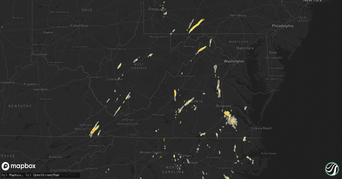
Hail Map in Virginia on June 11, 2014
Get this storm
June 11 map
$229
one time, instant access
Download today. No call, no setup
Keep the $229
Bought the map and want the full workflow? Apply the entire $229 to a subscription within 7 days. None of it is wasted.
Every map, not just this one
This buys you this map. Subscription and you get every map we run, in the markets you choose from a few cities to whole states to nationwide. Plus real-time alerts the moment a storm fires.
Contact data
Name, contact info, occupancy, even credit band for addresses in the footprint. You go from where it hit to who to call.
Become the source they trust
Unlimited branding weather history reports on demand. You already have the documented answer ready for the property owner, and you are the one who showed up with it.
Property data and RoofTrace estimates
Pull up any address you have got, its value and the exact code rules for that jurisdiction, straight from One Click Code. Then RoofTrace estimates the squares, pitch, and roof value, priced the way you price.
Storm reports in Virginia
Virginia
| Date | Description |
|---|---|
| 06/11/20146:44 PM CDT | Trees down in axton. |
| 06/11/20146:36 PM CDT | Tree down near intersection of blose road and red brush road. |
| 06/11/20146:36 PM CDT | Tree down near intersection of flower drive and dogwood circle. |
| 06/11/20145:53 PM CDT | Reported by a resident on tinderbox lane |
| 06/11/20145:49 PM CDT | A local report indicates 1.50 inch wind near 5 W WINCHESTER |
| 06/11/20145:35 PM CDT | At residence on day dr near rt 50 and hwy 614. |
| 06/11/20145:30 PM CDT | A local report indicates 1.00 inch wind near 1 E GORE |
| 06/11/20145:30 PM CDT | Golf ball sized hail damaged truck. |
| 06/11/20145:24 PM CDT | Several 6-8 diameter tree branches down |
| 06/11/20145:20 PM CDT | One tree down on route 20 near the intersection with little heaven lane |
| 06/11/20145:15 PM CDT | Trees down on the roof of a residence along james madison highway. |
| 06/11/20145:12 PM CDT | Trees down in arvonia along highway 15. |
| 06/11/20145:05 PM CDT | Multiple trees down along reservoir road leading to pedlar dam |
| 06/11/20145:00 PM CDT | Tree down at 605 and terranova drive |
| 06/11/20144:40 PM CDT | Dime to quarter size hail |
| 06/11/20144:40 PM CDT | Several trees down |
| 06/11/20144:30 PM CDT | Numerous trees down and snapped off. |
| 06/11/20144:23 PM CDT | One tree down. Power outage. |
| 06/11/20144:08 PM CDT | Trees down |
| 06/11/20144:05 PM CDT | Tree down |
| 06/11/20144:05 PM CDT | Large sycamore tree down on property along bergton rd. |
| 06/11/20144:04 PM CDT | Quarter size hail reported near alsop. |
| 06/11/20144:00 PM CDT | Tree down |
| 06/11/20143:58 PM CDT | Trees down in the 9600 block of liberty road. |
| 06/11/20143:54 PM CDT | Trees downed along river road near jarratt |
| 06/11/20143:50 PM CDT | Quarter size hail reported near gatewood. |
| 06/11/20143:45 PM CDT | Tree down on road...near 300 block of eidson creek rd. |
| 06/11/20143:42 PM CDT | Quarter size hail reported near gatewood. |
| 06/11/20143:42 PM CDT | Trees down on partlow road. |
| 06/11/20143:42 PM CDT | Quarter size hail reported near partlow. |
| 06/11/20143:41 PM CDT | Several trees downed along cabin point road |
| 06/11/20143:40 PM CDT | Quarter size hail reported near partlow. |
| 06/11/20143:38 PM CDT | Quarter size hail reported near partlow. |
| 06/11/20143:34 PM CDT | Quarter size hail covering the ground and a few two inch diameter tree limbs down |
| 06/11/20143:30 PM CDT | A local report indicates 1.00 inch wind near WAVERLY |
| 06/11/20143:21 PM CDT | Several trees downed along cabin point road |
| 06/11/20143:20 PM CDT | Lines down on borden grant trail. Tree down on n lee hwy. |
| 06/11/20143:18 PM CDT | A local report indicates 1.75 inch wind near FAIRFIELD |
| 06/11/20143:00 PM CDT | 12-14 inch tree down. |
| 06/11/20142:55 PM CDT | Trees down. |
| 06/11/20142:39 PM CDT | Power lines down along va hwy 47 |
| 06/11/20142:25 PM CDT | Golfball size hail |
| 06/11/20142:20 PM CDT | Crane toppled over at liberty university. Time estimated by radar. |
| 06/11/20142:20 PM CDT | A local report indicates 1.00 inch wind near 7 SSE ELMA |
| 06/11/20142:14 PM CDT | Power lines down on willowynde rd |
| 06/11/20142:12 PM CDT | Trees down |
| 06/11/20142:11 PM CDT | Tree down on northbound rt 29 just south of nelson co high school. |
| 06/11/20142:10 PM CDT | Trees down on east hundred road near fire training center |
| 06/11/20142:10 PM CDT | Conner rd |
| 06/11/20142:10 PM CDT | Trees down in new london |
| 06/11/20142:10 PM CDT | Trees down on east hundred road near fire training center |
| 06/11/20141:05 PM CDT | Several trees down. |
| 06/11/201412:00 PM CDT | Quarter size hail reported by public. |
| 06/11/201412:00 PM CDT | One tree down. |
| 06/11/201411:16 AM CDT | Golfball size hail reported in midway. |
| 06/10/20148:25 PM CDT | Two trees down off rt 221 |
| 06/10/20148:25 PM CDT | Two trees down off rt 221 |
| 06/10/20147:15 PM CDT | Nickel to quarter size hail at philpott dam rd and rt 57. |
| 06/10/20147:00 PM CDT | 12 inch diameter tree branch down and power outages |
All States Impacted by Hail Map on June 11, 2014
Cities Impacted by Hail Map on June 11, 2014
- Tarentum, PA
- New Kensington, PA
- Creighton, PA
- Springdale, PA
- Earlsboro, OK
- Seminole, OK
- Marienthal, KS
- Waverly, VA
- Disputanta, VA
- Spring Grove, VA
- Ionia, MI
- Orleans, MI
- Fenwick, MI
- Clendenin, WV
- Montebello, VA
- Dillwyn, VA
- Farmville, VA
- Buckingham, VA
- Perry, OK
- Billings, OK
- Marietta, SC
- Magnolia, NC
- Rose Hill, NC
- Ayr, NE
- Healy, KS
- Belding, MI
- Saranac, MI
- Gore, VA
- Winchester, VA
- Herndon, WV
- Kimball, WV
- Welch, WV
- Monroe, VA
- Bristol, VA
- Mendota, VA
- Partlow, VA
- Spotsylvania, VA
- Castlewood, VA
- Fort Blackmore, VA
- Dungannon, VA
- Nickelsville, VA
- Coeburn, VA
- Gate City, VA
- Saint Paul, VA
- Butler, MO
- Amsterdam, MO
- Archie, MO
- Adrian, MO
- Kingfisher, OK
- Clewiston, FL
- Immokalee, FL
- Winona, KS
- Graham, NC
- Haw River, NC
- Carbondale, KS
- Burlingame, KS
- Richmond, KS
- Greeley, KS
- Williamsburg, KS
- Wakarusa, KS
- Auburn, KS
- Princeton, KS
- Quenemo, KS
- Garnett, KS
- Pomona, KS
- Scranton, KS
- Harveyville, KS
- Eskridge, KS
- Ottawa, KS
- Overbrook, KS
- Charles City, VA
- Dendron, VA
- Colonial Heights, VA
- Wakefield, VA
- Prince George, VA
- Hopewell, VA
- Chester, VA
- Jarratt, VA
- Ahoskie, NC
- Cove City, NC
- Grifton, NC
- Dover, NC
- Vanceboro, NC
- Hastings, NE
- Juniata, NE
- South Hill, VA
- South Bay, FL
- Windsor, NC
- Union Mills, NC
- Blue Hill, NE
- Red Cloud, NE
- Lebanon, KS
- Inavale, NE
- Bladen, NE
- Burr Oak, KS
- Guide Rock, NE
- Freeman, MO
- Bradshaw, NE
- York, NE
- Wellington, KS
- Jamesville, NC
- Confluence, PA
- Addison, PA
- Martinsburg, WV
- Goodland, KS
- Britton, SD
- Fairfield, VA
- Raphine, VA
- Galivants Ferry, SC
- Aynor, SC
- Crawford, OK
- Durham, OK
- Gaylord, KS
- Downs, KS
- Esbon, KS
- Portis, KS
- Vona, CO
- West Newton, PA
- Clear Spring, MD
- Big Pool, MD
- Kearneysville, WV
- Hedgesville, WV
- Inwood, WV
- Falling Waters, WV
- Alamo, GA
- Wallace, KS
- Bucklin, KS
- Medford, OK
- Blountville, TN
- Bristol, TN
- Hollywood, FL
- Hialeah, FL
- Pembroke Pines, FL
- Verndale, MN
- Sebeka, MN
- Hydro, OK
- Lake City, SD
- Amherst, SD
- Langford, SD
- Hampton, NE
- Benedict, NE
- Ruther Glen, VA
- Beaverdam, VA
- Osawatomie, KS
- Higgins, TX
- Lipscomb, TX
- Holstein, NE
- Roseland, NE
- Petersburg, VA
- Warrenton, NC
- Macon, NC
- Aurora, NE
- Glenville, WV
- Robinson, KS
- Warthen, GA
- Mitchell, GA
- Scott City, KS
- Leoti, KS
- Loyal, OK
- Alma, KS
- Columbia, NC
- Middlebrook, VA
- Bassett, VA
- Beaver, WV
- Layland, WV
- Beckley, WV
- Mount Hope, WV
- Oak Hill, WV
- Lynchburg, VA
- Gladstone, VA
- Amherst, VA
- Rustburg, VA
- Madison Heights, VA
- Spencer, WV
- Gandeeville, WV
- Aulander, NC
- Manhattan, KS
- Lowell, MI
- Gloucester, VA
- Snow Camp, NC
- Pittsboro, NC
- Easley, SC
- Hobe Sound, FL
- Oskaloosa, KS
- Ozawkie, KS
- Arrington, VA
- Wingina, VA
- Howardsville, VA
- Schuyler, VA
- Norwood, VA
- Ellis, KS
- Durham, NC
- Morrisville, NC
- Cary, NC
- Giltner, NE
- Claremont, SD
- Lake City, KS
- Wilmore, KS
- Evington, VA
- Lynch Station, VA
- Plainville, KS
- Topeka, KS
- Ogallah, KS
- Gresham, NE
- Superior, NE
- Weskan, KS
- Douglas, OK
- Fairmont, OK
- Akron, CO
- Big Spring, TX
- Boydton, VA
- Mankato, KS
- Dighton, KS
- Greenleaf, KS
- Nora, VA
- Everett, PA
- Bedford, PA
- High View, WV
- Lane, KS
- Palmyra, VA
- Troy, VA
- Kents Store, VA
- Matthews, GA
- Sharon Springs, KS
- Campbell, NE
- Oakley, KS
- Henry, VA
- Dryden, TX
- Marathon, TX
- Stromsburg, NE
- Victoria, KS
- Gorham, KS
- Shattuck, OK
- Arnett, OK
- New Millport, PA
- Irvona, PA
- Olanta, PA
- Coalport, PA
- Glen Richey, PA
- Madera, PA
- Glen Hope, PA
- Clearfield, PA
- Tribune, KS
- Baskerville, VA
- Sedley, VA
- Fort Lee, VA
- Elberon, VA
- Henrico, VA
- Ivor, VA
- Apex, NC
- Hays, KS
- Wakeeney, KS
- Concordia, KS
- Belleville, KS
- Lawrence, NE
- Roper, NC
- Wright, KS
- Formoso, KS
- Alta Vista, KS
- Maple Hill, KS
- Creswell, NC
- Pickens, SC
- Liberty, SC
- Beaver, OK
- Kanorado, KS
- Green, KS
- Leonardville, KS
- Canadian, TX
- Ben Franklin, TX
- Roxton, TX
- Burlington, CO
- Bethune, CO
- Natoma, KS
- Alton, KS
- Woodston, KS
- Stockton, KS
- Osborne, KS
- West Palm Beach, FL
- Okarche, OK
- Ulysses, NE
- Pittsburgh, PA
- Cheswick, PA
- Shelby, NE
- Surprise, NE
- Seth, WV
- Bronson, KS
- Emporia, VA
- Palco, KS
- Hooker, OK
- Arapahoe, CO
- Henderson, NC
- Smithfield, NC
- Pine Level, NC
- Princeton, NC
- Selma, NC
- Swainsboro, GA
- Wamego, KS
- Paxico, KS
- McFarland, KS
- Sand Fork, WV
- Rockbridge Baths, VA
- Squire, WV
- Paynesville, WV
- Berwind, WV
- Miami, FL
- Homestead, FL
- Rotan, TX
- Franklin, VA
- Zuni, VA
- Okeechobee, FL
- Fairhope, PA
- Jewell, KS
- Hopewell, PA
- Buffalo Mills, PA
- Hyndman, PA
- Perryton, TX
- Gail, TX
- Fluvanna, TX
- Snyder, TX
- Sheridan Lake, CO
- Rhodell, WV
- Slab Fork, WV
- Piedmont, OK
- Lake Worth Beach, FL
- Lake Worth, FL
- Wishek, ND
- Ashley, ND
- Lehr, ND
- Pooler, GA
- Savannah, GA
- Delray Beach, FL
- Glenvil, NE
- Central, SC
- Six Mile, SC
- Verona, PA
- Smith Center, KS
- Mebane, NC
- Plant City, FL
- Kittrell, NC
- Franklinton, NC
- Quinter, KS
- Stratton, CO
- Cope, CO
- Anton, CO
- Rembert, SC
- Garden City, TX
- Stanton, TX
- Taloga, OK
- Goldsboro, NC
- Broad Run, VA
- Warrenton, VA
- Midland, VA
- Catlett, VA
- Bealeton, VA
- Lawrenceville, VA
- Mulhall, OK
- Coyle, OK
- Wadena, MN
- Utica, KS
- Ransom, KS
- Arnold, KS
- Warsaw, NC
- Turkey, NC
- Vesuvius, VA
- Thurmond, WV
- Harrisburg, NC
- Concord, NC
- Montpelier, VA
- Fredericksburg, VA
- Bumpass, VA
- Doswell, VA
- Joes, CO
- Trumbull, NE
- Edinburg, VA
- Corn, OK
- Weatherford, OK
- Spearville, KS
- Hollister, NC
- Chapel Hill, NC
- Valley Falls, KS
- Ellabell, GA
- Easton, KS
- Buckhannon, WV
- Pomeroy, OH
- Langsville, OH
- Rutland, OH
- Offerle, KS
- Carrboro, NC
- Booker, TX
- Rincon, GA
- Clinton, NC
- Faison, NC
- Gates, NC
- Corapeake, NC
- Ellendale, ND
- Windthorst, TX
- Cleveland, MO
- South Haven, KS
- Drexel, MO
- Harrisonville, MO
- Balko, OK
- Carson, VA
- Stony Creek, VA
- Enid, OK
- Fullerton, ND
- Bruceton Mills, WV
- Friendsville, MD
- Markleysburg, PA
- Hinton, VA
- Enfield, NC
- Jeannette, PA
- Adamsburg, PA
- Manor, PA
- Westmoreland City, PA
- Penn, PA
- Irwin, PA
- Port Wentworth, GA
- Bracey, VA
- Edson, KS
- Nardin, OK
- Lamont, OK
- Deer Creek, OK
- Whitakers, NC
- Suffolk, VA
- Sunbury, NC
- Chadbourn, NC
- Whiteville, NC
- Dante, VA
- Weber City, VA
- Kingsport, TN
- Manson, NC
- Hordville, NE
- Staunton, VA
- Greenville, VA
- Charlotte, NC
- Braman, OK
- Blackwell, OK
- Minneola, KS
- Turpin, OK
- El Reno, OK
- Yukon, OK
- Elizabeth City, NC
- Riverton, NE
- Chocowinity, NC
- La Cygne, KS
- Reidsville, NC
- Boynton Beach, FL
- Charleston, WV
- Elkview, WV
- Dwight, NE
- Waco, NE
- David City, NE
- Oceana, WV
- Four Oaks, NC
- Mount Olive, NC
- Boca Raton, FL
- Follett, TX
- Barnes, KS
- Hillsborough, NC
- Efland, NC
- Natrona Heights, PA
- Gerrardstown, WV
- San Saba, TX
- Hardy, NE
- Byron, NE
- Republic, KS
- Davin, WV
- Man, WV
- Gilbert, WV
- Verner, WV
- Mallory, WV
- Pendleton, SC
- Esmont, VA
- Long Island, VA
- Gretna, VA
- Nathalie, VA
- McCracken, KS
- La Crosse, KS
- Orlando, OK
- Keysville, GA
- Collyer, KS
- Scottsville, VA
- Vici, OK
- Six Mile Run, PA
- Louisburg, KS
- Kinsley, KS
- Hennessey, OK
- Bartow, FL
- Winter Haven, FL
- Lost Creek, WV
- North Augusta, SC
- Clarks Hill, SC
- Richmond, VA
- Staples, MN
- Linn, WV
- Normantown, WV
- Cedarville, WV
- Nebo, NC
- Knott, TX
- Turtle Creek, PA
- North Versailles, PA
- East Pittsburgh, PA
- Monroeville, PA
- Manns Choice, PA
- Fishertown, PA
- Schellsburg, PA
- New Paris, PA
- Forest, VA
- Sumerduck, VA
- Remington, VA
- Nisswa, MN
- Williamston, NC
- Frederick, SD
- Scandia, KS
- Paola, KS
- Currie, NC
- Eads, CO
- Dodge City, KS
- Weston, WV
- Volga, WV
- Hunter, OK
- Abingdon, VA
- Lebanon, VA
- Winston Salem, NC
- High Point, NC
- Thomasville, NC
- Browns Summit, NC
- Alum Bridge, WV
- Clarendon, NC
- Loris, SC
- Green Sea, SC
- Tabor City, NC
- Warsaw, MO
- Tonkawa, OK
- Garysburg, NC
- Sanford, NC
- Palm Beach, FL
- Kittanning, PA
- Templeton, PA
- Buena Vista, VA
- Pequot Lakes, MN
- Dry Creek, WV
- Holliday, TX
- McRae Helena, GA
- Brownell, KS
- Russell, KS
- Richardsville, VA
- Lignum, VA
- Jetmore, KS
- Jesse, WV
- Matheny, WV
- Belle Plaine, KS
- Herminie, PA
- Harrison City, PA
- Greensburg, PA
- Rillton, PA
- Claridge, PA
- Garden City, KS
- Belle, WV
- Chesterfield, VA
- Blythe, GA
- Plymouth, NC
- Danese, WV
- Stillwater, OK
- Ponca City, OK
- Newkirk, OK
- Kenansville, FL
- Spearman, TX
- Fargo, OK
- Fairview, OK
- Greensburg, KS
- Greensboro, NC
- Colfax, NC
- Kernersville, NC
- Eden, NC
- Crab Orchard, WV
- Hubbardston, MI
- Muir, MI
- Kirk, CO
- Stamford, TX
- Hamlin, TX
- Avoca, TX
- Roby, TX
- Hermleigh, TX
- McCaulley, TX
- Anson, TX
- Coahoma, TX
- Westbrook, TX
- Colorado City, TX
- Sterling City, TX


