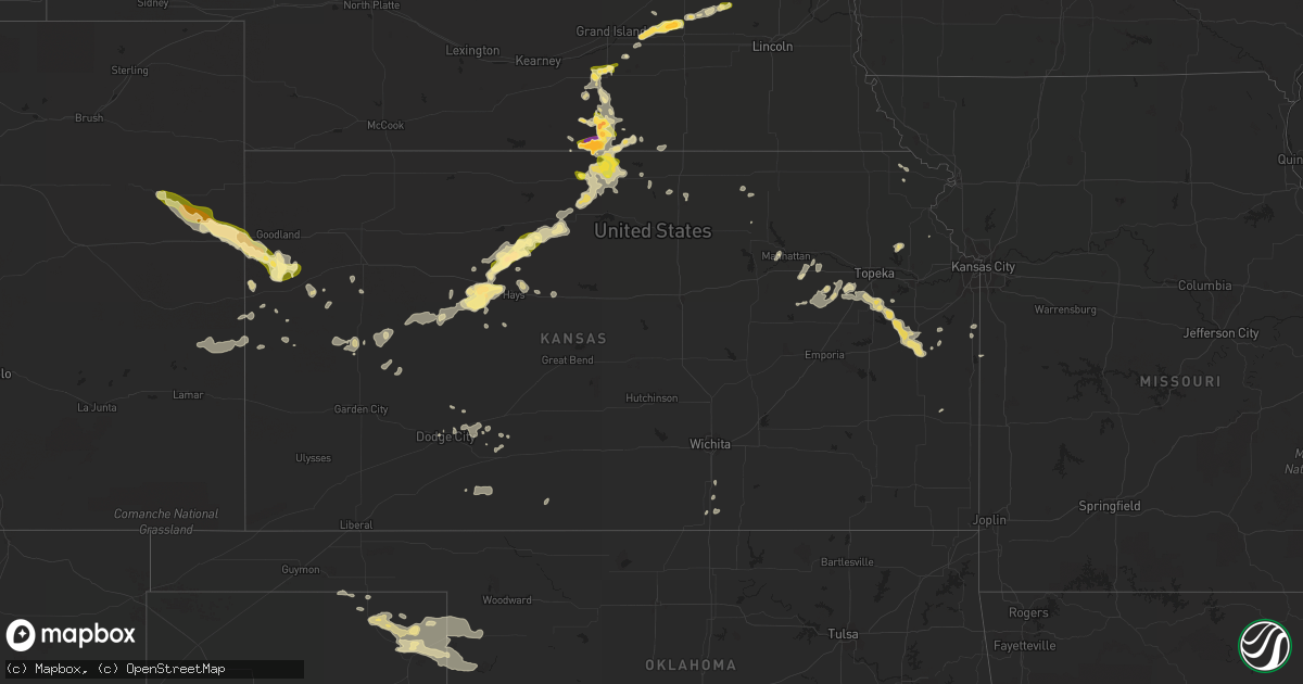
Hail Map in Kansas on June 11, 2014
Get this storm
June 11 map
$229
one time, instant access
Download today. No call, no setup
Keep the $229
Bought the map and want the full workflow? Apply the entire $229 to a subscription within 7 days. None of it is wasted.
Every map, not just this one
This buys you this map. Subscription and you get every map we run, in the markets you choose from a few cities to whole states to nationwide. Plus real-time alerts the moment a storm fires.
Contact data
Name, contact info, occupancy, even credit band for addresses in the footprint. You go from where it hit to who to call.
Become the source they trust
Unlimited branding weather history reports on demand. You already have the documented answer ready for the property owner, and you are the one who showed up with it.
Property data and RoofTrace estimates
Pull up any address you have got, its value and the exact code rules for that jurisdiction, straight from One Click Code. Then RoofTrace estimates the squares, pitch, and roof value, priced the way you price.
Storm reports in Kansas
Kansas
| Date | Description |
|---|---|
| 06/11/20146:59 PM CDT | A local report indicates 61 MPH wind near TRIBUNE |
| 06/11/20146:46 PM CDT | Mostly pea to nickel size over past 7 minutes. Relayed via spotternetwork. |
| 06/11/20146:25 PM CDT | A local report indicates 60 MPH wind near 5 WSW GOODLAND |
| 06/11/20146:15 PM CDT | A local report indicates 1.00 inch wind near KANORADO |
| 06/11/20146:15 PM CDT | A local report indicates 65 MPH wind near KANORADO |
| 06/11/20144:56 PM CDT | Time of tornado is approximate. |
| 06/11/20144:55 PM CDT | Rope tornado viewed from approx 5 south of tribune. |
| 06/11/20144:55 PM CDT | Rope tornado viewed from approx 5 south of tribune. Location estimated by spotter. |
| 06/11/201412:25 AM CDT | Tree limbs reported downed in salina by emergency management. |
| 06/11/201412:24 AM CDT | 2-3 inch limbs were reported down. Small limbs were reported down in medicine lodge. |
| 06/11/201412:19 AM CDT | A local report indicates 60 MPH wind near SALINA AIRPORT |
| 06/11/201412:14 AM CDT | A local report indicates 61 MPH wind near SALINA AIRPORT |
| 06/11/201412:14 AM CDT | 61 mph peak wind gust was measured at the salina municipal airport. |
| 06/11/201412:13 AM CDT | A local report indicates 65 MPH wind near 5 WSW SALINA |
| 06/11/201412:05 AM CDT | Downed 6 inch diameter tree limbs. |
| 06/11/201412:01 AM CDT | A local report indicates 60 MPH wind near ATTICA |
| 06/10/201411:33 PM CDT | A local report indicates 67 MPH wind near ELLSWORTH AIRPORT |
| 06/10/201411:17 PM CDT | A local report indicates 70 MPH wind near 3 W RAYMOND |
| 06/10/201411:15 PM CDT | Tree limbs estimated to be 6 inches in diameter down in the clifton area. |
| 06/10/201411:03 PM CDT | A local report indicates 60 MPH wind near TURON |
| 06/10/201410:55 PM CDT | A local report indicates 60 MPH wind near CONCORDIA AIRPORT |
| 06/10/201410:45 PM CDT | A local report indicates 60 MPH wind near GREAT BEND |
| 06/10/201410:45 PM CDT | Law enforcement reported downed tree branch approximately 6-8 inches in diameter on highway 50 in macksville. |
| 06/10/201410:38 PM CDT | A local report indicates 70 MPH wind near PAWNEE ROCK |
| 06/10/201410:35 PM CDT | A local report indicates 63 MPH wind near GREAT BEND ARPT |
| 06/10/201410:35 PM CDT | A local report indicates 63 MPH wind near MEDICINE LODGE |
| 06/10/201410:30 PM CDT | A flat roof was ripped off a business on the west side of larned. Also... A couple of 12-inch tree limbs were down... Also on the west side of larned. |
| 06/10/201410:30 PM CDT | A local report indicates 60 MPH wind near 3 NNW PAWNEE ROCK |
| 06/10/201410:26 PM CDT | Law enforecment reported train cars blown over along track from one-half mile west of la crosse into the city of la crosse itself. |
| 06/10/201410:10 PM CDT | 3-4 inch diameter tree limbs were blown down. |
| 06/10/201410:08 PM CDT | A local report indicates 62 MPH wind near 3 WNW LARNED |
| 06/10/201410:00 PM CDT | A local report indicates 60 MPH wind near 7 S ROZEL |
| 06/10/20149:51 PM CDT | A local report indicates 60 MPH wind near NESS CITY |
| 06/10/20149:50 PM CDT | A local report indicates 60 MPH wind near 10 NNW BURDETT |
| 06/10/20149:40 PM CDT | Sheets of metal were ripped off a building roof. The time was estimated. |
| 06/10/20149:25 PM CDT | Winds estimated gusting up to 60 mph on east side of jetmore. |
| 06/10/20149:13 PM CDT | Also... Had about 40 mph that took small limbs down. |
| 06/10/20149:12 PM CDT | A local report indicates 60 MPH wind near NESS CITY |
| 06/10/20149:03 PM CDT | 5 inch tree branches and estimated 65 mph winds reported east of garden city. |
| 06/10/20149:02 PM CDT | A local report indicates 91 MPH wind near 10 SW NESS CITY |
| 06/10/20149:00 PM CDT | Dime to quarter size hail |
| 06/10/20148:58 PM CDT | 56 knots or 64 mph was reported by the asos in garden city. |
| 06/10/20148:49 PM CDT | Reports of a few power poles as well as tree damage in dighton. |
| 06/10/20148:49 PM CDT | Reports of 6 inch tree limbs down as well as estimated 60 to 80 mph wind gusts. |
| 06/10/20148:40 PM CDT | The caller reported hail damage to his crop. He found quarter to half-dollar size divets from hain in the mud. |
| 06/10/20148:30 PM CDT | A local report indicates 68 MPH wind near SCOTT CITY |
| 06/10/20148:30 PM CDT | Also wind estimates of 65 mph. |
| 06/10/20148:30 PM CDT | Hail up to ping pong ball size was observed from 830 pm to 845 pm. |
| 06/10/20148:20 PM CDT | Mostly pea sized hail with a few quarters mixed in. Outflow moved through also est 25 to 30 mph winds with it. |
| 06/10/20148:14 PM CDT | Possibly related to frontal passage. |
| 06/10/20148:12 PM CDT | A local report indicates 1.75 inch wind near 5 WSW PLAINVILLE |
| 06/10/20148:00 PM CDT | Possible tornado damage...garage and barn destroyed. Roof heavily damaged. Two-by-fours thrown into wall. South side of home damaged. No injuries. Time approximate base |
| 06/10/20147:59 PM CDT | A local report indicates 1.00 inch wind near 5 SSE OGALLAH |
| 06/10/20147:56 PM CDT | A local report indicates 65 MPH wind near 4 NW MARIENTHAL |
| 06/10/20147:38 PM CDT | A local report indicates 59 MPH wind near 2 ESE OAKLEY |
| 06/10/20147:38 PM CDT | A local report indicates 59 MPH wind near 3 SE OAKLEY |
| 06/10/20147:38 PM CDT | Sustained 50 mph |
| 06/10/20147:14 PM CDT | Also had dime size hail |
All States Impacted by Hail Map on June 11, 2014
Cities Impacted by Hail Map on June 11, 2014
- Tarentum, PA
- New Kensington, PA
- Creighton, PA
- Springdale, PA
- Earlsboro, OK
- Seminole, OK
- Marienthal, KS
- Waverly, VA
- Disputanta, VA
- Spring Grove, VA
- Ionia, MI
- Orleans, MI
- Fenwick, MI
- Clendenin, WV
- Montebello, VA
- Dillwyn, VA
- Farmville, VA
- Buckingham, VA
- Perry, OK
- Billings, OK
- Marietta, SC
- Magnolia, NC
- Rose Hill, NC
- Ayr, NE
- Healy, KS
- Belding, MI
- Saranac, MI
- Gore, VA
- Winchester, VA
- Herndon, WV
- Kimball, WV
- Welch, WV
- Monroe, VA
- Bristol, VA
- Mendota, VA
- Partlow, VA
- Spotsylvania, VA
- Castlewood, VA
- Fort Blackmore, VA
- Dungannon, VA
- Nickelsville, VA
- Coeburn, VA
- Gate City, VA
- Saint Paul, VA
- Butler, MO
- Amsterdam, MO
- Archie, MO
- Adrian, MO
- Kingfisher, OK
- Clewiston, FL
- Immokalee, FL
- Winona, KS
- Graham, NC
- Haw River, NC
- Carbondale, KS
- Burlingame, KS
- Richmond, KS
- Greeley, KS
- Williamsburg, KS
- Wakarusa, KS
- Auburn, KS
- Princeton, KS
- Quenemo, KS
- Garnett, KS
- Pomona, KS
- Scranton, KS
- Harveyville, KS
- Eskridge, KS
- Ottawa, KS
- Overbrook, KS
- Charles City, VA
- Dendron, VA
- Colonial Heights, VA
- Wakefield, VA
- Prince George, VA
- Hopewell, VA
- Chester, VA
- Jarratt, VA
- Ahoskie, NC
- Cove City, NC
- Grifton, NC
- Dover, NC
- Vanceboro, NC
- Hastings, NE
- Juniata, NE
- South Hill, VA
- South Bay, FL
- Windsor, NC
- Union Mills, NC
- Blue Hill, NE
- Red Cloud, NE
- Lebanon, KS
- Inavale, NE
- Bladen, NE
- Burr Oak, KS
- Guide Rock, NE
- Freeman, MO
- Bradshaw, NE
- York, NE
- Wellington, KS
- Jamesville, NC
- Confluence, PA
- Addison, PA
- Martinsburg, WV
- Goodland, KS
- Britton, SD
- Fairfield, VA
- Raphine, VA
- Galivants Ferry, SC
- Aynor, SC
- Crawford, OK
- Durham, OK
- Gaylord, KS
- Downs, KS
- Esbon, KS
- Portis, KS
- Vona, CO
- West Newton, PA
- Clear Spring, MD
- Big Pool, MD
- Kearneysville, WV
- Hedgesville, WV
- Inwood, WV
- Falling Waters, WV
- Alamo, GA
- Wallace, KS
- Bucklin, KS
- Medford, OK
- Blountville, TN
- Bristol, TN
- Hollywood, FL
- Hialeah, FL
- Pembroke Pines, FL
- Verndale, MN
- Sebeka, MN
- Hydro, OK
- Lake City, SD
- Amherst, SD
- Langford, SD
- Hampton, NE
- Benedict, NE
- Ruther Glen, VA
- Beaverdam, VA
- Osawatomie, KS
- Higgins, TX
- Lipscomb, TX
- Holstein, NE
- Roseland, NE
- Petersburg, VA
- Warrenton, NC
- Macon, NC
- Aurora, NE
- Glenville, WV
- Robinson, KS
- Warthen, GA
- Mitchell, GA
- Scott City, KS
- Leoti, KS
- Loyal, OK
- Alma, KS
- Columbia, NC
- Middlebrook, VA
- Bassett, VA
- Beaver, WV
- Layland, WV
- Beckley, WV
- Mount Hope, WV
- Oak Hill, WV
- Lynchburg, VA
- Gladstone, VA
- Amherst, VA
- Rustburg, VA
- Madison Heights, VA
- Spencer, WV
- Gandeeville, WV
- Aulander, NC
- Manhattan, KS
- Lowell, MI
- Gloucester, VA
- Snow Camp, NC
- Pittsboro, NC
- Easley, SC
- Hobe Sound, FL
- Oskaloosa, KS
- Ozawkie, KS
- Arrington, VA
- Wingina, VA
- Howardsville, VA
- Schuyler, VA
- Norwood, VA
- Ellis, KS
- Durham, NC
- Morrisville, NC
- Cary, NC
- Giltner, NE
- Claremont, SD
- Lake City, KS
- Wilmore, KS
- Evington, VA
- Lynch Station, VA
- Plainville, KS
- Topeka, KS
- Ogallah, KS
- Gresham, NE
- Superior, NE
- Weskan, KS
- Douglas, OK
- Fairmont, OK
- Akron, CO
- Big Spring, TX
- Boydton, VA
- Mankato, KS
- Dighton, KS
- Greenleaf, KS
- Nora, VA
- Everett, PA
- Bedford, PA
- High View, WV
- Lane, KS
- Palmyra, VA
- Troy, VA
- Kents Store, VA
- Matthews, GA
- Sharon Springs, KS
- Campbell, NE
- Oakley, KS
- Henry, VA
- Dryden, TX
- Marathon, TX
- Stromsburg, NE
- Victoria, KS
- Gorham, KS
- Shattuck, OK
- Arnett, OK
- New Millport, PA
- Irvona, PA
- Olanta, PA
- Coalport, PA
- Glen Richey, PA
- Madera, PA
- Glen Hope, PA
- Clearfield, PA
- Tribune, KS
- Baskerville, VA
- Sedley, VA
- Fort Lee, VA
- Elberon, VA
- Henrico, VA
- Ivor, VA
- Apex, NC
- Hays, KS
- Wakeeney, KS
- Concordia, KS
- Belleville, KS
- Lawrence, NE
- Roper, NC
- Wright, KS
- Formoso, KS
- Alta Vista, KS
- Maple Hill, KS
- Creswell, NC
- Pickens, SC
- Liberty, SC
- Beaver, OK
- Kanorado, KS
- Green, KS
- Leonardville, KS
- Canadian, TX
- Ben Franklin, TX
- Roxton, TX
- Burlington, CO
- Bethune, CO
- Natoma, KS
- Alton, KS
- Woodston, KS
- Stockton, KS
- Osborne, KS
- West Palm Beach, FL
- Okarche, OK
- Ulysses, NE
- Pittsburgh, PA
- Cheswick, PA
- Shelby, NE
- Surprise, NE
- Seth, WV
- Bronson, KS
- Emporia, VA
- Palco, KS
- Hooker, OK
- Arapahoe, CO
- Henderson, NC
- Smithfield, NC
- Pine Level, NC
- Princeton, NC
- Selma, NC
- Swainsboro, GA
- Wamego, KS
- Paxico, KS
- McFarland, KS
- Sand Fork, WV
- Rockbridge Baths, VA
- Squire, WV
- Paynesville, WV
- Berwind, WV
- Miami, FL
- Homestead, FL
- Rotan, TX
- Franklin, VA
- Zuni, VA
- Okeechobee, FL
- Fairhope, PA
- Jewell, KS
- Hopewell, PA
- Buffalo Mills, PA
- Hyndman, PA
- Perryton, TX
- Gail, TX
- Fluvanna, TX
- Snyder, TX
- Sheridan Lake, CO
- Rhodell, WV
- Slab Fork, WV
- Piedmont, OK
- Lake Worth Beach, FL
- Lake Worth, FL
- Wishek, ND
- Ashley, ND
- Lehr, ND
- Pooler, GA
- Savannah, GA
- Delray Beach, FL
- Glenvil, NE
- Central, SC
- Six Mile, SC
- Verona, PA
- Smith Center, KS
- Mebane, NC
- Plant City, FL
- Kittrell, NC
- Franklinton, NC
- Quinter, KS
- Stratton, CO
- Cope, CO
- Anton, CO
- Rembert, SC
- Garden City, TX
- Stanton, TX
- Taloga, OK
- Goldsboro, NC
- Broad Run, VA
- Warrenton, VA
- Midland, VA
- Catlett, VA
- Bealeton, VA
- Lawrenceville, VA
- Mulhall, OK
- Coyle, OK
- Wadena, MN
- Utica, KS
- Ransom, KS
- Arnold, KS
- Warsaw, NC
- Turkey, NC
- Vesuvius, VA
- Thurmond, WV
- Harrisburg, NC
- Concord, NC
- Montpelier, VA
- Fredericksburg, VA
- Bumpass, VA
- Doswell, VA
- Joes, CO
- Trumbull, NE
- Edinburg, VA
- Corn, OK
- Weatherford, OK
- Spearville, KS
- Hollister, NC
- Chapel Hill, NC
- Valley Falls, KS
- Ellabell, GA
- Easton, KS
- Buckhannon, WV
- Pomeroy, OH
- Langsville, OH
- Rutland, OH
- Offerle, KS
- Carrboro, NC
- Booker, TX
- Rincon, GA
- Clinton, NC
- Faison, NC
- Gates, NC
- Corapeake, NC
- Ellendale, ND
- Windthorst, TX
- Cleveland, MO
- South Haven, KS
- Drexel, MO
- Harrisonville, MO
- Balko, OK
- Carson, VA
- Stony Creek, VA
- Enid, OK
- Fullerton, ND
- Bruceton Mills, WV
- Friendsville, MD
- Markleysburg, PA
- Hinton, VA
- Enfield, NC
- Jeannette, PA
- Adamsburg, PA
- Manor, PA
- Westmoreland City, PA
- Penn, PA
- Irwin, PA
- Port Wentworth, GA
- Bracey, VA
- Edson, KS
- Nardin, OK
- Lamont, OK
- Deer Creek, OK
- Whitakers, NC
- Suffolk, VA
- Sunbury, NC
- Chadbourn, NC
- Whiteville, NC
- Dante, VA
- Weber City, VA
- Kingsport, TN
- Manson, NC
- Hordville, NE
- Staunton, VA
- Greenville, VA
- Charlotte, NC
- Braman, OK
- Blackwell, OK
- Minneola, KS
- Turpin, OK
- El Reno, OK
- Yukon, OK
- Elizabeth City, NC
- Riverton, NE
- Chocowinity, NC
- La Cygne, KS
- Reidsville, NC
- Boynton Beach, FL
- Charleston, WV
- Elkview, WV
- Dwight, NE
- Waco, NE
- David City, NE
- Oceana, WV
- Four Oaks, NC
- Mount Olive, NC
- Boca Raton, FL
- Follett, TX
- Barnes, KS
- Hillsborough, NC
- Efland, NC
- Natrona Heights, PA
- Gerrardstown, WV
- San Saba, TX
- Hardy, NE
- Byron, NE
- Republic, KS
- Davin, WV
- Man, WV
- Gilbert, WV
- Verner, WV
- Mallory, WV
- Pendleton, SC
- Esmont, VA
- Long Island, VA
- Gretna, VA
- Nathalie, VA
- McCracken, KS
- La Crosse, KS
- Orlando, OK
- Keysville, GA
- Collyer, KS
- Scottsville, VA
- Vici, OK
- Six Mile Run, PA
- Louisburg, KS
- Kinsley, KS
- Hennessey, OK
- Bartow, FL
- Winter Haven, FL
- Lost Creek, WV
- North Augusta, SC
- Clarks Hill, SC
- Richmond, VA
- Staples, MN
- Linn, WV
- Normantown, WV
- Cedarville, WV
- Nebo, NC
- Knott, TX
- Turtle Creek, PA
- North Versailles, PA
- East Pittsburgh, PA
- Monroeville, PA
- Manns Choice, PA
- Fishertown, PA
- Schellsburg, PA
- New Paris, PA
- Forest, VA
- Sumerduck, VA
- Remington, VA
- Nisswa, MN
- Williamston, NC
- Frederick, SD
- Scandia, KS
- Paola, KS
- Currie, NC
- Eads, CO
- Dodge City, KS
- Weston, WV
- Volga, WV
- Hunter, OK
- Abingdon, VA
- Lebanon, VA
- Winston Salem, NC
- High Point, NC
- Thomasville, NC
- Browns Summit, NC
- Alum Bridge, WV
- Clarendon, NC
- Loris, SC
- Green Sea, SC
- Tabor City, NC
- Warsaw, MO
- Tonkawa, OK
- Garysburg, NC
- Sanford, NC
- Palm Beach, FL
- Kittanning, PA
- Templeton, PA
- Buena Vista, VA
- Pequot Lakes, MN
- Dry Creek, WV
- Holliday, TX
- McRae Helena, GA
- Brownell, KS
- Russell, KS
- Richardsville, VA
- Lignum, VA
- Jetmore, KS
- Jesse, WV
- Matheny, WV
- Belle Plaine, KS
- Herminie, PA
- Harrison City, PA
- Greensburg, PA
- Rillton, PA
- Claridge, PA
- Garden City, KS
- Belle, WV
- Chesterfield, VA
- Blythe, GA
- Plymouth, NC
- Danese, WV
- Stillwater, OK
- Ponca City, OK
- Newkirk, OK
- Kenansville, FL
- Spearman, TX
- Fargo, OK
- Fairview, OK
- Greensburg, KS
- Greensboro, NC
- Colfax, NC
- Kernersville, NC
- Eden, NC
- Crab Orchard, WV
- Hubbardston, MI
- Muir, MI
- Kirk, CO
- Stamford, TX
- Hamlin, TX
- Avoca, TX
- Roby, TX
- Hermleigh, TX
- McCaulley, TX
- Anson, TX
- Coahoma, TX
- Westbrook, TX
- Colorado City, TX
- Sterling City, TX


