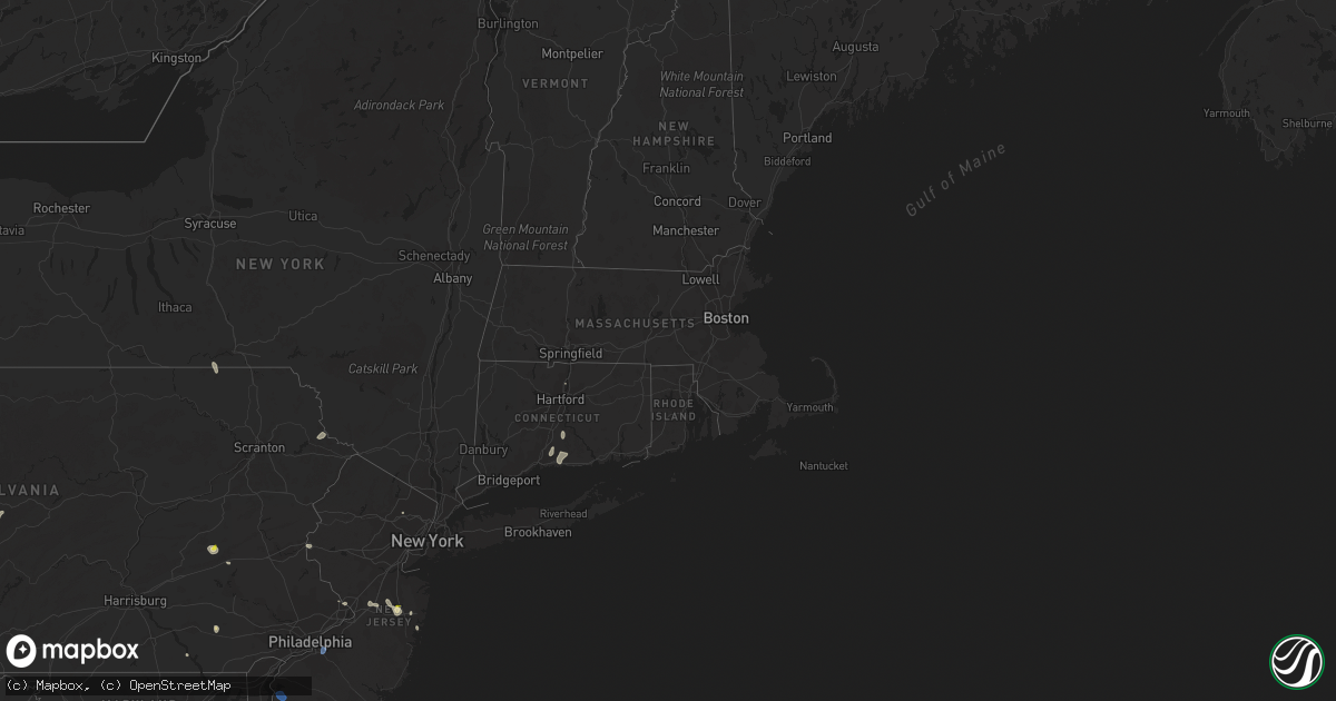
Hail Map in Connecticut on June 9, 2021
Get this storm
June 9 map
$229
one time, instant access
Download today. No call, no setup
Keep the $229
Bought the map and want the full workflow? Apply the entire $229 to a subscription within 7 days. None of it is wasted.
Every map, not just this one
This buys you this map. Subscription and you get every map we run, in the markets you choose from a few cities to whole states to nationwide. Plus real-time alerts the moment a storm fires.
Contact data
Name, contact info, occupancy, even credit band for addresses in the footprint. You go from where it hit to who to call.
Become the source they trust
Unlimited branding weather history reports on demand. You already have the documented answer ready for the property owner, and you are the one who showed up with it.
Property data and RoofTrace estimates
Pull up any address you have got, its value and the exact code rules for that jurisdiction, straight from One Click Code. Then RoofTrace estimates the squares, pitch, and roof value, priced the way you price.
Storm reports in Connecticut
Connecticut
| Date | Description |
|---|---|
| 06/09/20214:54 PM CDT | Multiple trees reported down in guilford with time estimated by radar. |
| 06/09/20214:54 PM CDT | Report from mping: 3-inch tree limbs broken; power poles broken. |
| 06/09/20214:22 PM CDT | Report from mping: 1-inch tree limbs broken; shingles blown off. |
| 06/09/20214:12 PM CDT | Tree and branches reported down in front of 15 foot hills road just past milbrook road. |
| 06/09/202112:11 AM CDT | At 510 PM EDT, a severe thunderstorm was located over Durham, moving south at 20 mph. HAZARD...60 mph wind gusts and nickel size hail. SOURCE...Radar indicated. IMPACT...Expect damage to trees and power lines. This severe thunderstorm will be near... Durham around 515 PM EDT. Guilford, North Branford and Killingworth around 525 PM EDT. Westbrook and North Madison around 540 PM EDT. Clinton around 550 PM EDT. |
| 06/08/202110:23 PM CDT | At 323 PM EDT, a severe thunderstorm was located over East Windsor, or near Enfield, moving southeast at 15 mph. HAZARD...60 mph wind gusts and quarter size hail. SOURCE...Radar indicated. IMPACT...Expect wind damage to trees and power lines. Minor hail damage to vehicles is possible. Locations impacted include... Manchester, East Hartford, Enfield, Glastonbury, Vernon, Windsor, Mansfield, South Windsor, Suffield, Ellington, Tolland, Windsor Locks, Coventry, Somers, East Windsor, Hebron, Willington, Bolton and Andover. |
All States Impacted by Hail Map on June 9, 2021
Cities Impacted by Hail Map on June 9, 2021
- Fife Lake, MI
- South Boardman, MI
- Big Sandy, MT
- Hays, MT
- Chinook, MT
- Lloyd, MT
- England, AR
- Littlefork, MN
- Hawley, PA
- Greeley, PA
- Lackawaxen, PA
- Fort Stockton, TX
- Dodson, MT
- Zortman, MT
- Malta, MT
- Scott, AR
- Little Rock, AR
- North Little Rock, AR
- Sherwood, AR
- Wyndmere, ND
- Pewamo, MI
- Saint Johns, MI
- Fowler, MI
- Forestburgh, NY
- Brackney, PA
- Little Meadows, PA
- Roy, MT
- Loring, MT
- Fort Benton, MT
- Orr, MN
- Geyser, MT
- New Holland, PA
- Paradise, PA
- Kinzers, PA
- Gordonville, PA
- Crane, TX
- Mountain Dale, NY
- Fergus Falls, MN
- Heber Springs, AR
- Pangburn, AR
- Searcy, AR
- Gloversville, NY
- Dover, DE
- Frederica, DE
- Dover Afb, DE
- Camden Wyoming, DE
- Magnolia, DE
- Windsor, CT
- Live Oak, FL
- McAlpin, FL
- Verndale, MN
- Kelliher, MN
- Pine Bush, NY
- Conway, AR
- Greenbrier, AR
- Bigfork, MN
- Max, MN
- Spring Lake, MN
- Greene, NY
- Cope, SC
- Cordova, SC
- Badger, MN
- Greenbush, MN
- Schlater, MS
- Elbow Lake, MN
- Millsboro, DE
- Box Elder, MT
- Winifred, MT
- Imperial, TX
- Schuylkill Haven, PA
- Orwigsburg, PA
- Auburn, PA
- Saco, MT
- Deer River, MN
- Philipsburg, PA
- Hawk Run, PA
- Scotland, AR
- Clinton, AR
- Havre, MT
- Alexandria, MN
- Carlos, MN
- Farmingdale, NJ
- Howell, NJ
- Kalkaska, MI
- Kabetogama, MN
- Bovey, MN
- Whitewater, MT
- Grandfalls, TX
- Gildford, MT
- Bertha, MN
- Parkers Prairie, MN
- Hewitt, MN
- Thomaston, AL
- Waynesboro, MS
- Ocean View, DE
- Millville, DE
- Frankford, DE
- Itta Bena, MS
- Freehold, NJ
- Airville, PA
- Rock Hill, NY
- Monticello, NY
- Cook, MN
- Carlisle, AR
- International Falls, MN
- Brick, NJ
- Dagsboro, DE
- Morrisville, PA
- Hankinson, ND
- Magnolia, AL
- Ponemah, MN
- Blackduck, MN
- Rose Bud, AR
- Northford, CT
- North Branford, CT
- Pottsville, PA
- Macclesfield, NC
- O'Brien, FL
- Easton, PA
- Phillipsburg, NJ
- Lake Butler, FL
- Greenwood, MS
- Selbyville, DE
- Harbeson, DE
- Bishopville, MD
- Georgetown, DE
- Geraldine, MT
- Vining, MN
- Battle Lake, MN
- Underwood, MN
- Clitherall, MN
- Chenango Forks, NY
- Port Crane, NY
- Turner, MT
- Stevensville, MT
- Hightstown, NJ
- Robbinsville, NJ
- Millstone Township, NJ
- Roosevelt, NJ
- Windsor, NJ
- Hingham, MT
- Talmoon, MN
- Hookerton, NC
- Jackson, NJ
- Loma, MT
- Wayne, NJ
- Lewes, DE
- Milton, DE
- Des Arc, AR
- Griffithville, AR
- Saint Paul, MN
- Mendota, MN
- Harlem, MT
- Disputanta, VA
- Eldred, NY
- Pierpont, SD
- Englishtown, NJ
- Goodridge, MN
- Vestal, NY
- Apalachin, NY
- Monroe, LA
- Columbia, LA
- Grayson, LA
- Coffee Creek, MT
- Heathsville, VA
- Sanderson, FL
- Brunswick, GA
- Hamburg, PA
- Letona, AR
- Foley, MN
- Marion, LA
- Alachua, FL
- Savannah, GA
- Trenton, NJ
- Bloomingburg, NY
- Durham, CT
- Middletown, CT
- McRae, AR
- Beebe, AR
- Guilford, CT
- Madison, CT
- Erhard, MN
- Elizabeth, MN
- Saint Thomas, ND
- Cherry Hill, NJ
- Barrington, NJ
- Haddonfield, NJ
- Lawnside, NJ
- Magnolia, NJ
- Corvallis, MT
- Fenwick Island, DE
- Ocean City, MD
- Bethany Beach, DE
- Salem, NJ
- Cary, MS
- Rolling Fork, MS
- Bolton, MS
- Crystal, ND
- Hoople, ND


