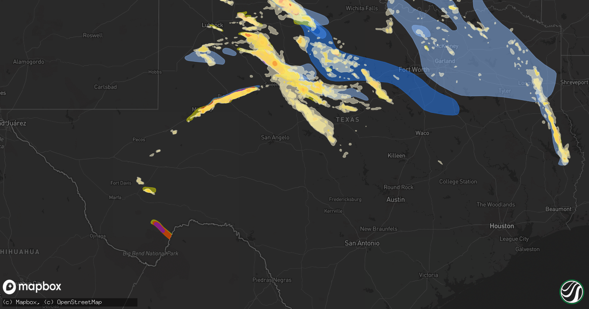
Hail Map in Texas on June 8, 2025
Get this storm
June 8 map
$229
one time, instant access
Download today. No call, no setup
Keep the $229
Bought the map and want the full workflow? Apply the entire $229 to a subscription within 7 days. None of it is wasted.
Every map, not just this one
This buys you this map. Subscription and you get every map we run, in the markets you choose from a few cities to whole states to nationwide. Plus real-time alerts the moment a storm fires.
Contact data
Name, contact info, occupancy, even credit band for addresses in the footprint. You go from where it hit to who to call.
Become the source they trust
Unlimited branding weather history reports on demand. You already have the documented answer ready for the property owner, and you are the one who showed up with it.
Property data and RoofTrace estimates
Pull up any address you have got, its value and the exact code rules for that jurisdiction, straight from One Click Code. Then RoofTrace estimates the squares, pitch, and roof value, priced the way you price.
Storm reports in Texas
Texas
| Date | Description |
|---|---|
| 06/08/20256:54 PM CDT | Report from mping: half dollar |
| 06/08/20256:50 PM CDT | 911 call center has recieved reports of numerous trees down across the county. Many county roads and main roads have trees down. Road crews are currently attempting to |
| 06/08/20256:46 PM CDT | Size ranged from 0.5 to 1 inch. |
| 06/08/20256:46 PM CDT | Peak wind gust measured by the west texas mesonet. Additional gusts of 58 mph or greater occurred between 6:43 and 6:50 pm. |
| 06/08/20256:46 PM CDT | Time of hail estimated. |
| 06/08/20256:45 PM CDT | Time of hail fall estimated. |
| 06/08/20256:40 PM CDT | Photo received from the public of hail slightly larger than quarters just outside of cooper. |
| 06/08/20256:40 PM CDT | Sheriffs office reported quarter size hail falling at their office. |
| 06/08/20256:40 PM CDT | Report from mping: golf ball |
| 06/08/20256:38 PM CDT | Picture of hail from social media. Time of hail fall estimated. |
| 06/08/20256:37 PM CDT | Report from mping: half dollar |
| 06/08/20256:36 PM CDT | Icechip report measured at 24mm and rounded for report. |
| 06/08/20256:35 PM CDT | Picture of 2.069 inch diameter hail precisely measured. Time of hail is estimated. |
| 06/08/20256:35 PM CDT | Wind and dirt blew very intensely. The winds caused tree damage and blew in the north side of a large shed some. Time damage occurred is estimated. |
| 06/08/20256:35 PM CDT | Report from mping: quarter |
| 06/08/20256:35 PM CDT | Time of hail estimated. |
| 06/08/20256:35 PM CDT | A local report indicates 2.50 inch wind near 4 S Paducah |
| 06/08/20256:33 PM CDT | Peak wind gust measured by the west texas mesonet. Gusts of 60 mph or greater occurred between 6:32 and 6:37 pm. |
| 06/08/20256:32 PM CDT | Report from mping: quarter |
| 06/08/20256:32 PM CDT | Report from mping of quarter sized hail. |
| 06/08/20256:31 PM CDT | Icechip report measured at 35mm and rounded for report. |
| 06/08/20256:30 PM CDT | Pictures of hail as large as 2.5 inches in diameter. Time of hail fall is estimated. |
| 06/08/20256:25 PM CDT | Picture of large tree limbs down in paducah. Time of damage estimated. |
| 06/08/20256:25 PM CDT | Public reports ping pong ball sized hail near bland lake. |
| 06/08/20256:24 PM CDT | Report from mping: half dollar |
| 06/08/20256:24 PM CDT | Icechip report measured at 30mm and rounded for report. |
| 06/08/20256:22 PM CDT | Reports of measured one inch hail stones at the intersection of hwy 205 and cr 182. |
| 06/08/20256:15 PM CDT | Icechip report measured at 33mm and rounded for report. |
| 06/08/20256:15 PM CDT | A local report indicates 1.50 inch wind near 7 W Channing |
| 06/08/20256:14 PM CDT | Hail as large as golf balls falling currently. |
| 06/08/20256:10 PM CDT | Icechip report measured at 33mm and rounded for report. |
| 06/08/20256:04 PM CDT | Report from mping: golf ball |
| 06/08/20256:00 PM CDT | Steeple of church blown off. Time of damage estimated. |
| 06/08/20256:00 PM CDT | A local report indicates 58 MPH wind near 10 WNW Pyote |
| 06/08/20256:00 PM CDT | A local report indicates 1.00 inch wind near Panhandle |
| 06/08/20256:00 PM CDT | Power pole bent over the roadway. Lines still attached... Hanging at about 6 to 7 feet above the roadway. Time is when the report came in. Damage may have occurred earl |
| 06/08/20255:58 PM CDT | Social media report of golf ball size hail near hwy 7. |
| 06/08/20255:53 PM CDT | Images from social media of hail measuring three quarter of an inch to one inch south of lipan. |
| 06/08/20255:51 PM CDT | Measured by the west texas mesonet. Another gust to 60 mph was measured at 5:53 pm. |
| 06/08/20255:50 PM CDT | Quarter size hail reported in morgan mill by fd. |
| 06/08/20255:46 PM CDT | Report from mping: quarter |
| 06/08/20255:44 PM CDT | Quarter size hail in lake dallas via amateur radio. |
| 06/08/20255:26 PM CDT | Report from mping: quarter |
| 06/08/20255:25 PM CDT | Report from icechip research team. |
| 06/08/20255:25 PM CDT | A local report indicates 1.25 inch wind near 5 WSW Borger |
| 06/08/20255:25 PM CDT | Report from mping. Quarter size hail. |
| 06/08/20255:24 PM CDT | Report from mping. Quarter size hail. |
| 06/08/20255:21 PM CDT | West texas mesonet. Also measured a gust to 59 mph at 5:22 pm. |
| 06/08/20255:20 PM CDT | Damage to the first baptist church of timpson reported via broadcast media source. |
| 06/08/20255:19 PM CDT | Report from mping: hen egg |
| 06/08/20255:13 PM CDT | Report from mping: golf ball |
| 06/08/20255:10 PM CDT | 2.2 inch hail measured by icechip. Time of hail is estimated. |
| 06/08/20255:09 PM CDT | Nssl team measured a 90 mph wind gust with their mobile mesonet. The winds overturned a center pivot near this location. |
| 06/08/20255:09 PM CDT | Nssl team measured a 90 mph wind gust with their mobile mesonet. The winds overturned a center pivot near this location. (lu |
| 06/08/20255:07 PM CDT | Report from mping: hen egg+ |
| 06/08/20254:54 PM CDT | Report of half dollar size hail near the intersection of county road 106 and county road 103. |
| 06/08/20254:49 PM CDT | A local report indicates 1.75 inch wind near Stinnett |
| 06/08/20254:40 PM CDT | Mesonet gusted to 65 mph at 1640cdt and continued to gust above 58 mph until 1646cdt. Peak gust of 83 mph occurred at 1642cdt. |
| 06/08/20254:40 PM CDT | Reports of a lost barn and roof damage. Time estimated from radar. |
| 06/08/20254:39 PM CDT | Emergency manager confirmed tornado was on the ground. |
| 06/08/20254:30 PM CDT | Report on social media indicates structural damage at a convenience store/gas station with large window blown in. |
| 06/08/20254:30 PM CDT | Photo submitted via social media. |
| 06/08/20254:27 PM CDT | Corrects previous tornado report from 2 n borger. Tornado damage preliminarily supports ef0. The tornado was likely on the ground for one minute. Photos were obtained f |
| 06/08/20254:23 PM CDT | A local report indicates 1.50 inch wind near Stinnett |
| 06/08/20254:20 PM CDT | Storm chaser reported a funnel reaching the ground multiple times before quickly going back up. |
| 06/08/20254:16 PM CDT | A local report indicates 1.50 inch wind near Stinnett |
| 06/08/20254:16 PM CDT | Report from mping: grapefruit+ |
| 06/08/20254:11 PM CDT | Report from mping: baseball++ |
| 06/08/20254:05 PM CDT | Report from mping: quarter |
| 06/08/20253:52 PM CDT | A local report indicates 1.75 inch wind near 10 ESE Texline |
| 06/08/20253:51 PM CDT | 911 call center received reports of several trees and powerlines down in the vicinity of longview heights. |
| 06/08/20253:51 PM CDT | A local report indicates 1.50 inch wind near 7 S Claude |
| 06/08/20253:42 PM CDT | A local report indicates 1.75 inch wind near 9 S Claude |
| 06/08/20253:40 PM CDT | Report from mping: quarter |
| 06/08/20253:38 PM CDT | Report from mping: quarter |
| 06/08/20253:17 PM CDT | Picture submitted via slack of a tornado on the ground. |
| 06/08/20253:15 PM CDT | A local report indicates 1.25 inch wind near 10 W Claude |
| 06/08/20252:46 PM CDT | Report from mping: quarter |
| 06/08/20252:41 PM CDT | Report from mping: half dollar |
| 06/08/202511:58 AM CDT | Social media report of 68mph sustained winds recorded via personal weather station. |
| 06/08/202511:11 AM CDT | A local report indicates 60 MPH wind near Weatherford |
| 06/08/20258:31 AM CDT | A local report indicates 1.50 inch wind near 3 NW Sylvester |
| 06/08/20258:16 AM CDT | Report from mping: quarter |
| 06/08/20258:10 AM CDT | Report from mping: baseball |
| 06/08/20258:07 AM CDT | Mesonet station 113 5w rotan rotan/fisher county. |
| 06/08/202512:39 AM CDT | Asos station kmaf midland. |
| 06/08/202512:35 AM CDT | Kinj awos. |
| 06/08/202512:30 AM CDT | Report of multiple trees down in overton... Tx. |
| 06/08/202512:10 AM CDT | A local report indicates 1.00 inch wind near 3 ENE Tuscola |
| 06/07/202511:58 PM CDT | Social media images of tree around 8 to 12 inches in diameter... Snapped around 6 feet off the ground. Time estimated. |
| 06/07/202511:49 PM CDT | Report from mping: golf ball |
| 06/07/202511:49 PM CDT | Report fro |
| 06/07/202511:47 PM CDT | Report from mping: half dolla |
| 06/07/202511:47 PM CDT | Report from mping: half dollar |
| 06/07/202511:47 PM CDT | A local report indicates 2.50 inch wind near 3 SE Dyess Afb |
| 06/07/202511:45 PM CDT | Report from mping: golf ball |
| 06/07/202511:45 PM CDT | Em report of a tree on a house 3.5 sw of pittsburg. |
| 06/07/202511:44 PM CDT | A local report indicates 61 MPH wind near 2 WNW Clyde |
| 06/07/202511:42 PM CDT | *** 1 fatal *** corrects previous tstm wnd dmg report from 4 sw pittsburg. Corrected location and time. Tree fell on a manufactured home. |
| 06/07/202511:40 PM CDT | Mesonet station 26 gail 2se. |
| 06/07/202511:40 PM CDT | A local report indicates 71 MPH wind near 2 SW White Settlement |
| 06/07/202511:40 PM CDT | A local report indicates 60 MPH wind near 2 W Joshua |
| 06/07/202511:34 PM CDT | Report from mping: ping pong ball |
| 06/07/202511:25 PM CDT | Tree down along temple hall highway. |
| 06/07/202511:19 PM CDT | 78 mph wind gust at the west texas mesonet location on the acu campus. |
| 06/07/202511:17 PM CDT | Mesonet station 84 2wnw tarzan/martin county. |
| 06/07/202511:17 PM CDT | Multiple branches down. Fence knocked down. |
| 06/07/202511:12 PM CDT | Report of trees down in titus county. |
| 06/07/202511:11 PM CDT | Corrects previous tstm wnd gst report from weatherford. |
| 06/07/202511:02 PM CDT | Spotter network report. |
| 06/07/202511:00 PM CDT | Emergency manager reported a few trees down near the fm 906 and fm 197. Time estimated by radar. |
| 06/07/202510:57 PM CDT | Dfw airport asos gusted to 68 mph. |
| 06/07/202510:56 PM CDT | Mesonet station 18 lamesa 2se. |
| 06/07/202510:56 PM CDT | Report from mping: quarter |
| 06/07/202510:55 PM CDT | Awos station kluv lamesa. |
| 06/07/202510:53 PM CDT | Mineral wells asos gusted to 69 mph. |
| 06/07/202510:50 PM CDT | 60 mph wind gust measured at lakeside park. |
| 06/07/202510:47 PM CDT | Image of tree fallen onto home in cumby... Causing damage to roof. |
| 06/07/202510:44 PM CDT | Images of roof torn off metal building and powerlines downed on hwy 180 west of mineral wells. |
| 06/07/202510:43 PM CDT | Multiple 60 mph wind reports in and near richardson. |
| 06/07/202510:39 PM CDT | Trained spotter via ham radio reported in golfball size hail over i-20 in baird... Tx. |
| 06/07/202510:35 PM CDT | Report from mping: half dollar |
| 06/07/202510:34 PM CDT | Social media image of windows blown in at rw miller power plant. Time estimated. |
| 06/07/202510:34 PM CDT | Report from mping: half dollar |
| 06/07/202510:33 PM CDT | A local report indicates 67 MPH wind near 5 SSW Graham |
| 06/07/202510:29 PM CDT | 60 mph winds reported in honey grove. |
| 06/07/202510:27 PM CDT | Images of small metal outbuilding destroyed in coalville area. |
| 06/07/202510:22 PM CDT | Social media images of porch roof torn off of home... Small metal outbuilding destroyed in gordon... Texas. |
| 06/07/202510:19 PM CDT | Trees downed and roof damage to metal buildings along dairy farm road. |
| 06/07/202510:16 PM CDT | Mesonet station 96 welch dawson county. |
| 06/07/202510:15 PM CDT | Emergency management reports estimated 80 mph wind gusts and trees down in dodd city. |
| 06/07/202510:15 PM CDT | Emergency management reports thunderstorm wind damage and debris along us 82 near hwy 78 and hwy 121. |
| 06/07/202510:12 PM CDT | Reports of grain silos collapsed in windom. |
| 06/07/202510:12 PM CDT | Trees down in strawn... Texas. |
| 06/07/202510:10 PM CDT | Report of widespread tree damage and some structure damage in dodd city. Time estimated. |
| 06/07/202510:07 PM CDT | A local report indicates 65 MPH wind near 5 SSW Graham |
| 06/07/202510:07 PM CDT | Trained spotter reports a measured wind gust of 65 mph at i-35e and 407 northwest of lewisville. |
| 06/07/202510:05 PM CDT | Trained spotter reported 1 inch hail over noodle... Tx via ham radio. |
| 06/07/202510:00 PM CDT | Widespread wind damage reported near ravenna. Time estimated. |
| 06/07/20259:57 PM CDT | A local report indicates 60 MPH wind near 5 SSW Graham |
| 06/07/20259:50 PM CDT | Ham radio estimates 50-60 mph wind gusts in the city of alvord. |
| 06/07/20259:48 PM CDT | Emergency management reports a large tree blown over on suv. Driver trapped but no apparent injuries. |
| 06/07/20259:44 PM CDT | Ham radio reports a measured wind gust of 63 mph at twu guinn hall. |
| 06/07/20259:42 PM CDT | Trained spotter reports a measured wind gust of 82 mph near the fm922 and fm2848 intersection north of sanger. |
| 06/07/20259:40 PM CDT | Weather station north of collinsville reported 62 mph wind gust. |
| 06/07/20259:35 PM CDT | Report from mping: half dollar |
| 06/07/20259:33 PM CDT | Trained spotter estimates 55-60 mph wind gusts 2 miles wnw of tioga. |
| 06/07/20259:29 PM CDT | Report from mping: half dollar |
| 06/07/20259:27 PM CDT | Emergency management reports a measured wind gust of 69 mph 4 miles west of callisburg. |
| 06/07/20259:25 PM CDT | A local report indicates 66 MPH wind near 4 ENE Albany |
| 06/07/20259:24 PM CDT | A local report indicates 61 MPH wind near 2 SE Truscott |
| 06/07/20259:19 PM CDT | Emergency management estimates 60 mph wind gusts in the city of callisburg. Power is out in the area. |
| 06/07/20259:17 PM CDT | A local report indicates 68 MPH wind near 2 SE Truscott |
| 06/07/20259:15 PM CDT | Nws san antonio/austin relayed a report from a spotter stating they saw golfball size hail in woodson... Tx around 9:15 pm. |
| 06/07/20259:05 PM CDT | Woodson fire dept reported 1 inch hail 1 mile north of woodson. |
| 06/07/20259:05 PM CDT | Woodson fire department reported 70 to 75 mph wind gusts. |
| 06/07/20258:50 PM CDT | Law enforcement reported multiple powerlines down along fm57 north. |
| 06/07/20258:45 PM CDT | Law enforcement reported a hog farm e of roby... Tx had damage to their property and multiple powerlines down along the road. |
| 06/07/20258:45 PM CDT | A local report indicates 86 MPH wind near 3 N Avoca |
| 06/07/20258:35 PM CDT | Mesonet station 105 5nw colorado city. |
| 06/07/20258:34 PM CDT | Time estimated from radar. |
| 06/07/20258:29 PM CDT | Report from mping: quarter |
| 06/07/20258:26 PM CDT | Downed power poles and lines along road. |
| 06/07/20258:24 PM CDT | Time estimated by radar. |
| 06/07/20258:20 PM CDT | A local report indicates 66 MPH wind near 2 NNW Haskell |
| 06/07/20258:20 PM CDT | Corrects previous tstm wnd gst report from 2 nnw haskell. |
| 06/07/20258:17 PM CDT | Report from mping: quarter |
| 06/07/20258:10 PM CDT | Semi rolled over on highway 277. |
| 06/07/20258:10 PM CDT | A local report indicates 100 MPH wind near 4 NNW Goree |
| 06/07/20258:05 PM CDT | A local report indicates 60 MPH wind near 3 NW Knox City |
| 06/07/20258:05 PM CDT | A local report indicates 68 MPH wind near 4 NNW Goree |
| 06/07/20258:05 PM CDT | A local report indicates 75 MPH wind near Persimmon Gap |
| 06/07/20258:05 PM CDT | ( |
| 06/07/20258:03 PM CDT | A local report indicates 2.50 inch wind near Coahoma |
| 06/07/20258:01 PM CDT | A local report indicates 73 MPH wind near 2 NNE Weinert |
| 06/07/20258:01 PM CDT | A local report indicates 58 MPH wind near Midway |
| 06/07/20258:00 PM CDT | Emergency manager reports a roof was damaged at a school. Numerous trees were also down across the city. Time estimated via radar. |
| 06/07/20258:00 PM CDT | A local report indicates 60 MPH wind near 3 NW Knox City |
| 06/07/20258:00 PM CDT | A local report indicates 68 MPH wind near 4 NNW Goree |
| 06/07/20257:58 PM CDT | A local report indicates 81 MPH wind near 4 W Rotan |
| 06/07/20257:58 PM CDT | Corrects previous tstm wnd gst report from 5 w rotan. |
| 06/07/20257:55 PM CDT | A local report indicates 60 MPH wind near 3 NW Knox City |
| 06/07/20257:53 PM CDT | Described as having fallen near mm179 on i-20. |
| 06/07/20257:52 PM CDT | Peak wind gust measured by the west texas mesonet with this round of storms. Additional gusts of 59 mph or greater occurred at 7:51 and 7:53 pm. |
| 06/07/20257:50 PM CDT | Time estimated from radar. |
| 06/07/20257:50 PM CDT | Multiple reports that most west facing windows are broken at hotel settles in big spring due to damaging wind-driven hail. |
| 06/07/20257:45 PM CDT | A local report indicates 66 MPH wind near 3 NW Knox City |
| 06/07/20257:42 PM CDT | Mesonet station 59 3nw knox city. |
| 06/07/20257:37 PM CDT | Sheriff department reported multiple trees down and power outages around the browndell area. Time estimated from radar. |
| 06/07/20257:30 PM CDT | Report from mping: half dollar |
| 06/07/20257:25 PM CDT | A local report indicates 81 MPH wind near 2 SE Truscott |
| 06/07/20257:21 PM CDT | A local report indicates 64 MPH wind near 5 SW Saint Lawrence |
| 06/07/20257:20 PM CDT | A local report indicates 67 MPH wind near 3 NW Greenwood |
| 06/07/20257:20 PM CDT | A local report indicates 81 MPH wind near 2 SE Truscott |
| 06/07/20257:18 PM CDT | Report from mping: hen egg |
| 06/07/20257:15 PM CDT | A power pole snapped on fm 267. |
| 06/07/20257:15 PM CDT | A local report indicates 80 MPH wind near 2 SE Truscott |
| 06/07/20257:12 PM CDT | Picture provided by em. Time estimated by radar. |
| 06/07/20257:11 PM CDT | Report of wind driven hail damaging windows of an rv/trailer. Time estimated by radar. |
| 06/07/20257:10 PM CDT | A local report indicates 74 MPH wind near 2 SE Truscott |
| 06/07/20257:05 PM CDT | A local report indicates 1.25 inch wind near 2 WNW Midland |
| 06/07/20257:05 PM CDT | A local report indicates 1.75 inch wind near 2 NW Midland |
All States Impacted by Hail Map on June 8, 2025
Cities Impacted by Hail Map on June 8, 2025
- Snyder, TX
- Jayton, TX
- Girard, TX
- Rotan, TX
- Crosbyton, TX
- Hamlin, TX
- Sylvester, TX
- Roby, TX
- McCaulley, TX
- Troy, SC
- Bradley, SC
- Ninety Six, SC
- Dickens, TX
- Merkel, TX
- Anson, TX
- Summerton, SC
- Pinewood, SC
- Elloree, SC
- Bowman, SC
- Luray, SC
- Lynchburg, SC
- Manning, SC
- Saint George, SC
- Silverton, TX
- Holly Hill, SC
- Vance, SC
- Perryton, TX
- Reevesville, SC
- Lockney, TX
- Dorchester, SC
- Eutawville, SC
- Kingstree, SC
- Salters, SC
- Greeleyville, SC
- Lane, SC
- Sweet Water, AL
- Quitaque, TX
- Cross, SC
- Matador, TX
- Scranton, SC
- Turkey, TX
- Flomot, TX
- Ridgeville, SC
- Gresham, SC
- Marion, SC
- Pamplico, SC
- Dixons Mills, AL
- Chadbourn, NC
- Magnolia, AL
- Linden, AL
- Fair Bluff, NC
- Clarkton, NC
- Elizabethtown, NC
- Mullins, SC
- Nichols, SC
- Cerro Gordo, NC
- Pine Hill, AL
- Thomasville, AL
- Arlington, AL
- Whiteville, NC
- Kelly, NC
- Council, NC
- Clarendon, TX
- Georgetown, SC
- Ivanhoe, NC
- Loris, SC
- Green Sea, SC
- Fort Stewart, GA
- Tabor City, NC
- Conway, SC
- Atkinson, NC
- Currie, NC
- Coy, AL
- Longs, SC
- Nakina, NC
- Bolton, NC
- Paducah, TX
- Lake Waccamaw, NC
- Camden, AL
- Rocky Point, NC
- Burgaw, NC
- Ash, NC
- Beatrice, AL
- Riegelwood, NC
- Delco, NC
- Vredenburgh, AL
- Longwood, NC
- Childress, TX
- Castle Hayne, NC
- Kenton, OK
- Elkhart, KS
- Goodwell, OK
- Supply, NC
- Waynesville, GA
- Waverly, GA
- Jacksonville, NC
- Hilton Head Island, SC
- Wilmington, NC
- Pine Apple, AL
- Crowell, TX
- Peterman, AL
- Evergreen, AL
- New Zion, SC
- Pinopolis, SC
- Camp Lejeune, NC
- Liberal, KS
- Pineville, SC
- Hugoton, KS
- Hubert, NC
- Boise City, OK
- McKenzie, AL
- Stella, NC
- Swansboro, NC
- Newport, NC
- Garnett, KS
- Wrightsville Beach, NC
- Hooker, OK
- Centerville, KS
- Blue Mound, KS
- Dozier, AL
- Greenville, AL
- Red Level, AL
- Waynoka, OK
- Mooreland, OK
- Georgiana, AL
- Guymon, OK
- Tyrone, OK
- Alva, OK
- Felt, OK
- Wellington, TX
- Memphis, TX
- Harrisburg, MO
- Mound City, KS
- Mapleton, KS
- Dodson, TX
- Hollis, OK
- Maple Park, IL
- Elburn, IL
- Jet, OK
- Cimarron, KS
- Dekalb, IL
- Columbia, MO
- Cherokee, OK
- Geneva, IL
- Batavia, IL
- North Aurora, IL
- Mooseheart, IL
- Wilson, KS
- Uniontown, KS
- Redfield, KS
- Andalusia, AL
- Fulton, KS
- Dorrance, KS
- Spearville, KS
- Monterey, LA
- Moreauville, LA
- Lettsworth, LA
- Turpin, OK
- Sugar Grove, IL
- Moran, KS
- Wakita, OK
- Nash, OK
- Lake City, SC
- Sumter, SC
- Prescott, KS
- Fort Scott, KS
- Warrenville, IL
- Aurora, IL
- West Chicago, IL
- Naperville, IL
- Winfield, IL
- Claude, TX
- Wheaton, IL
- Medford, OK
- Winfield, KS
- Ellsworth, KS
- Longton, KS
- Dexter, KS
- Butler, MO
- Angola, LA
- Woodville, MS
- Cedar Vale, KS
- Bronson, KS
- Fredonia, KS
- Saint Francisville, LA
- Carmen, OK
- Dodge City, KS
- Elk City, KS
- Mount Hermon, LA
- Franklinton, LA
- Neodesha, KS
- Divide, CO
- Woodland Park, CO
- Dalhart, TX
- Pond Creek, OK
- Woodridge, IL
- Downers Grove, IL
- Lisle, IL
- Westmont, IL
- Glen Ellyn, IL
- Helena, OK
- Montrose, MO
- Saint Charles, IL
- Sedan, KS
- Chipley, FL
- Diana, TX
- Longview, TX
- Opp, AL
- Wasco, IL
- Urich, MO
- Green Mountain Falls, CO
- Cascade, CO
- Pollock, LA
- Ensign, KS
- Clinton, MO
- Stark, KS
- Elba, AL
- Hallsville, TX
- Tallula, IL
- Ashland, IL
- Pleasant Plains, IL
- Gilmer, TX
- Fort Davis, TX
- Mansura, LA
- Hessmer, LA
- Chanute, KS
- Texline, TX
- La Grange, IL
- Clarendon Hills, IL
- Hinsdale, IL
- Willowbrook, IL
- Justice, IL
- Darien, IL
- Western Springs, IL
- Hickory Hills, IL
- Bridgeview, IL
- Willow Springs, IL
- Summit Argo, IL
- Stinnett, TX
- Morse, TX
- Balko, OK
- Honey Grove, TX
- Petty, TX
- Deepwater, MO
- Sunray, TX
- Panhandle, TX
- Springfield, IL
- Cantrall, IL
- Farlington, KS
- Arcadia, KS
- Petersburg, IL
- Leland, NC
- Kinston, AL
- Hepler, KS
- Garland, KS
- Alpine, TX
- Cottonport, LA
- Cambridge, KS
- Caldwell, KS
- Borger, TX
- Nardin, OK
- Tonkawa, OK
- Blackwell, OK
- Lamont, OK
- Deer Creek, OK
- South Haven, KS
- Braman, OK
- Savonburg, KS
- Independence, KS
- Samson, AL
- Manchester, OK
- Maple City, KS
- Newkirk, OK
- Marshall, TX
- Tatum, TX
- Strawn, TX
- Arma, KS
- Kanopolis, KS
- Kaw City, OK
- Booker, TX
- Ben Franklin, TX
- Roxton, TX
- Shidler, OK
- Pawhuska, OK
- Girard, KS
- Mulberry, KS
- Beckville, TX
- Brookville, KS
- Gordon, TX
- Chester, OK
- Longdale, OK
- Seiling, OK
- Pampa, TX
- Miami, TX
- Fairview, OK
- Skellytown, TX
- Marathon, TX
- Ponca City, OK
- Burbank, OK
- Geuda Springs, KS
- Arkansas City, KS
- Simmesport, LA
- Pittsburg, KS
- White Deer, TX
- Marksville, LA
- Wiggins, MS
- Spearman, TX
- Coffeyville, KS
- Plaucheville, LA
- Franklin, KS
- Frontenac, KS
- Batchelor, LA
- Palo Pinto, TX
- Wheeler, TX
- Sweetwater, OK
- Carthage, TX
- Long Branch, TX
- Gary, TX
- Asbury, MO
- Weir, KS
- S Coffeyville, OK
- Wann, OK
- Groom, TX
- Fort Stockton, TX
- Oronogo, MO
- Webb City, MO
- Carl Junction, MO
- Timpson, TX
- Tenaha, TX
- Jasper, MO
- Columbus, KS
- Ranger, TX
- Lenapah, OK
- Canton, OK
- Scammon, KS
- Galena, KS
- Hartley, TX
- Lakeview, TX
- Shawano, WI
- Cheyenne, OK
- Yeso, NM
- Westcliffe, CO
- Watonga, OK
- Lucedale, MS
- Vici, OK
- Delaware, OK
- Champlain, VA
- Warsaw, VA
- Burden, KS
- Ladonia, TX
- Center, TX
- Stephenville, TX
- Santo, TX
- Lipan, TX
- Mutual, OK
- Denton, TX
- Lake Dallas, TX
- Grenola, KS
- Canadian, TX
- Big Island, VA
- Pound, WI
- Suring, WI
- Mingus, TX
- Joplin, MO
- Bluff Dale, TX
- Fort Sumner, NM
- Henderson, TX
- Adrian, MO
- Warrensburg, MO
- Riverton, KS
- Garden City, MO
- Leeton, MO
- Creighton, MO
- Knob Noster, MO
- Baxter Springs, KS
- Copan, OK
- Bartlesville, OK
- Mcadoo, TX
- Howard, KS
- Moline, KS
- Seneca, MO
- Quapaw, OK
- Cee Vee, TX
- Tell, TX
- Green Ridge, MO
- Cooper, TX
- Oakwood, OK
- Sayre, OK
- Pecan Gap, TX
- Okeene, OK
- Windsor, MO
- Reydon, OK
- Elk Falls, KS
- Crane, TX
- Gladstone, NM
- Springer, NM
- Opolis, KS
- Mclean, TX
- Fay, OK
- San Augustine, TX
- Fall River, KS
- Walnut Springs, TX
- Thomas, OK
- Arapaho, OK
- Weatherford, OK
- Taloga, OK
- Geary, OK
- Custer City, OK
- Wetmore, CO
- Fritch, TX
- Citronelle, AL
- Sedan, NM
- Skiatook, OK
- Gardner, CO
- Clinton, OK
- Butler, OK
- Elk City, OK
- Hammon, OK
- Putnam, OK
- Canute, OK
- Hobart, OK
- Rocky, OK
- Gotebo, OK
- Sentinel, OK
- Cordell, OK
- Corn, OK
- Dill City, OK
- Foss, OK
- Bessie, OK
- Leedey, OK
- Carter, OK
- Ralls, TX
- Justiceburg, TX
- Post, TX
- Spur, TX
- Greenfield, OK
- Calumet, OK
- McIntosh, AL
- Amelia Court House, VA
- Brewton, AL
- Severy, KS
- Hydro, OK
- Odessa, TX
- Franktown, CO
- Elizabeth, CO
- Midland, TX
- Vega, TX
- Gainestown, AL
- Ore City, TX
- Appleton City, MO
- Rockville, MO
- Castleberry, AL
- Des Moines, NM
- Channing, TX
- Hinton, OK
- Osceola, MO
- Garrison, TX
- Elbert, CO
- Jackson, AL
- Bronson, TX
- Republic, MI
- Champion, MI
- Montpelier, VA
- Seymour, TX
- Bonham, TX
- Pineland, TX
- Broaddus, TX
- Windom, TX
- Dodd City, TX
- Chelsea, OK
- Adair, OK
- Broken Arrow, OK
- Inola, OK
- Claremore, OK
- Pryor, OK
- Oologah, OK
- Catoosa, OK
- Collinsville, OK
- Benjamin, TX
- Stanton, TX
- Garden City, TX
- Barnsdall, OK
- Ramona, OK
- Vera, OK
- Talala, OK
- Wynona, OK
- Munday, TX
- Goree, TX
- Ochelata, OK
- Sperry, OK
- Tulsa, OK
- Owasso, OK
- Chouteau, OK
- Locust Grove, OK
- Spavinaw, OK
- Salina, OK
- Strang, OK
- Rose, OK
- Big Cabin, OK
- Amarillo, TX
- Hedley, TX
- Atmore, AL
- Wagarville, AL
- Glen Allen, VA
- Ashland, VA
- Doswell, VA
- Little River, AL
- Tolar, TX
- Brookeland, TX
- Big Spring, TX
- Aspermont, TX
- Rolla, MO
- Laurel Hill, FL
- Quincy, MO
- Florala, AL
- La Harpe, KS
- Steelville, MO
- Roswell, NM
- Jasper, TX
- Salem, MO
- Coahoma, TX
- Hereford, TX
- Broadview, NM
- Sullivan, MO
- Versailles, MO
- Gravois Mills, MO
- Barnett, MO
- Frisco City, AL
- Collins, MO
- Bunkie, LA
- Walsenburg, CO
- Westbrook, TX
- Rocky Mount, MO
- Eldon, MO
- Tuttle, OK
- Minco, OK
- Union City, OK
- Mustang, OK
- Blanchard, OK
- Rochester, TX
- Capulin, NM
- Masterson, TX
- Mount Vernon, TX
- Licking, MO
- Weaubleau, MO
- Wheatland, MO
- Hemphill, TX
- Davisville, MO
- Knox City, TX
- Weinert, TX
- Throckmorton, TX
- O'Brien, TX
- Colorado City, TX
- Folsom, NM
- Haskell, TX
- Sweetwater, TX
- Calera, OK
- Cartwright, OK
- Tuscumbia, MO
- Defuniak Springs, FL
- Mount Pleasant, TX
- Wynnewood, OK
- Wiergate, TX
- Rule, TX
- Hico, TX
- Cadet, MO
- Mineral Point, MO
- Wayside, TX
- Henrico, VA
- Jefferson, TX
- Newcastle, OK
- Lueders, TX
- Stamford, TX
- Albany, TX
- Avoca, TX
- Woodson, TX
- Trent, TX
- Davis, OK
- Glen Rose, TX
- Tishomingo, OK
- Pittsburg, TX
- Hawley, TX
- Springer, OK
- Ratliff City, OK
- Hennepin, OK
- Healdton, OK
- Graham, OK
- Wilson, OK
- Ardmore, OK
- Lone Grove, OK
- Madill, OK
- Mannsville, OK
- Overbrook, OK
- Marietta, OK
- Burneyville, OK
- Muenster, TX
- Leon, OK
- Saint Jo, TX
- Ringling, OK
- Happy, TX
- Henley, MO
- Eugene, MO
- Archie, MO
- Hart, TX
- Pauls Valley, OK
- Harrisonville, MO
- Buffalo, KS
- Gainesville, TX
- Thackerville, OK
- Abilene, TX
- Newcastle, TX
- Graham, TX
- Breckenridge, TX
- Kingston, OK
- Mead, OK
- Lebanon, OK
- Whitesboro, TX
- Lindsay, TX
- Valley View, TX
- Saint Elizabeth, MO
- Harleton, TX
- Loraine, TX
- Atoka, OK
- Jay, FL
- Avinger, TX
- Tulia, TX
- Moran, TX
- Water View, VA
- Kaiser, MO
- Iola, KS
- Walnut, KS
- Bunker, MO
- Toronto, KS
- Coyanosa, TX
- Roaring Springs, TX
- Hendrix, OK
- Colbert, OK
- Durant, OK
- Pottsboro, TX
- Denison, TX
- Collinsville, TX
- Howe, TX
- Sherman, TX
- Sadler, TX
- Pilot Point, TX
- Tioga, TX
- Gunter, TX
- Osage Beach, MO
- Sunrise Beach, MO
- Milton, FL
- Clayton, NM
- Caddo, TX
- Cisco, TX
- Whitewright, TX
- Celina, TX
- Van Alstyne, TX
- Anna, TX
- Era, TX
- Sanger, TX
- Aubrey, TX
- Savoy, TX
- Bells, TX
- Ravenna, TX
- Ellington, MO
- Edgar Springs, MO
- Kress, TX
- Leasburg, MO
- Plainview, TX
- Centerville, MO
- Petersburg, TX
- Floydada, TX
- Lorenzo, TX
- Bixby, MO
- Lane, OK
- Latham, KS
- Brownfield, TX
- Afton, TX
- Holt, FL
- Argyle, TX
- Prosper, TX
- Flower Mound, TX
- Little Elm, TX
- Frisco, TX
- Lewisville, TX
- Krum, TX
- Ponder, TX
- Montague, TX
- Rosston, TX
- Forestburg, TX
- Decatur, TX
- Nocona, TX
- Terral, OK
- Ryan, OK
- Ringgold, TX
- Mckinney, TX
- Trenton, TX
- Princeton, TX
- Blue Ridge, TX
- Celeste, TX
- Wolfe City, TX
- Farmersville, TX
- Leonard, TX
- Bailey, TX
- Melissa, TX
- The Colony, TX
- Randolph, TX
- Ector, TX
- Tahoka, TX
- Boss, MO
- Tye, TX
- Kenefic, OK
- Caddo, OK
- Odonnell, TX
- Caulfield, MO
- Bison, OK
- Clyde, TX
- Wilson, TX
- Charlotte Court House, VA
- Pamplin, VA
- Dora, MO
- West Plains, MO
- Stringtown, OK
- Boswell, OK
- Bennington, OK
- Talco, TX
- Willow Springs, MO
- Dyess Afb, TX
- Seagraves, TX
- Pottersville, MO
- Baird, TX
- Waurika, OK
- Loop, TX
- Welch, TX
- Lamesa, TX
- Gail, TX
- Bogata, TX
- Clarksville, TX
- Mineral Wells, TX
- South Bend, TX
- Weatherford, TX
- Graford, TX
- Millsap, TX
- Granbury, TX
- Southlake, TX
- Bedford, TX
- Addison, TX
- Roanoke, TX
- Allen, TX
- Fort Worth, TX
- Dallas, TX
- Richardson, TX
- Grapevine, TX
- Irving, TX
- Euless, TX
- Colleyville, TX
- Coppell, TX
- Carrollton, TX
- Wylie, TX
- Arlington, TX
- Plano, TX
- Garland, TX
- Sachse, TX
- Nevada, TX
- Greenville, TX
- Grand Prairie, TX
- Lavon, TX
- Caddo Mills, TX
- Rowlett, TX
- Hurst, TX
- Arthur City, TX
- Sumner, TX
- Powderly, TX
- Hugo, OK
- Paris, TX
- Telephone, TX
- Brookston, TX
- Rockwall, TX
- Commerce, TX
- Klondike, TX
- Royse City, TX
- Enloe, TX
- Duncanville, TX
- Campbell, TX
- Pattonville, TX
- Detroit, TX
- Blossom, TX
- Deport, TX
- Cumby, TX
- Lake Creek, TX
- Mesquite, TX
- Sulphur Springs, TX
- Sunnyvale, TX
- Lone Oak, TX
- Desoto, TX
- Alba, TX
- Seagoville, TX
- Balch Springs, TX
- Yantis, TX
- Pickton, TX
- Cedar Hill, TX
- Brashear, TX
- Emory, TX
- Quinlan, TX
- Hutchins, TX
- Forney, TX
- Terrell, TX
- Crandall, TX
- Fruitvale, TX
- Saltillo, TX
- Wills Point, TX
- Quitman, TX
- Sulphur Bluff, TX
- Lancaster, TX
- Point, TX
- Dike, TX
- Como, TX
- Edgewood, TX
- Wilmer, TX
- Kaufman, TX
- Grand Saline, TX
- Mineola, TX
- Sumrall, MS
- Columbia, MS
- Koshkonong, MO
- Mammoth Spring, AR
- Salem, AR
- Lake George, CO
- Isabella, OK
- Piedmont, KS
- Bassfield, MS
- Winona, MO
- Alton, MO
- Gould, OK
- Mangum, OK
- Canton, TX
- Tuscola, TX
- Van Buren, MO
- McCune, KS
- Omaha, TX
- Rising Star, TX
- Fremont, MO
- Cross Plains, TX
- Venus, TX
- Lillian, TX
- Mansfield, TX
- Cresson, TX
- Crowley, TX
- Midlothian, TX
- Cleburne, TX
- Alvarado, TX
- Aledo, TX
- Godley, TX
- Joshua, TX
- Burleson, TX
- Grandview, TX
- Hillsboro, TX
- Rio Vista, TX
- Itasca, TX
- Blum, TX
- Covington, TX
- Waxahachie, TX
- Maypearl, TX
- Keene, TX
- Hughes Springs, TX
- Scroggins, TX
- Cookville, TX
- Winnsboro, TX
- Winfield, TX
- Daingerfield, TX
- Naples, TX
- Leesburg, TX
- Lone Star, TX
- Tyler, TX
- Hawkins, TX
- Kemp, TX
- Van, TX
- Eustace, TX
- Winona, TX
- Scurry, TX
- Murchison, TX
- Athens, TX
- Lindale, TX
- Big Sandy, TX
- Ben Wheeler, TX
- Chandler, TX
- Ferris, TX
- Brownsboro, TX
- Mabank, TX
- Red Oak, TX
- Ennis, TX
- Palmer, TX
- Chatfield, TX
- Rosser, TX
- Flint, TX
- Malakoff, TX
- Taiban, NM
- Glenallen, MO
- Eastland, TX
- Eglin Afb, FL
- Bowie, TX
- Bellevue, TX
- Roscoe, TX
- Sunset, TX
- Grandin, MO
- Gorman, TX
- Carbon, TX
- Barry, TX
- Rice, TX
- Milford, TX
- Italy, TX
- Forreston, TX
- Corsicana, TX
- Frost, TX
- Blooming Grove, TX
- Bynum, TX
- Mertens, TX
- Purdon, TX
- Pomona, MO
- Lumberton, MS
- Jackson, MO
- Cape Girardeau, MO
- Kilgore, TX
- Karnack, TX
- Gladewater, TX
- White Oak, TX
- Arp, TX
- Overton, TX
- Laneville, TX
- Selman City, TX
- Mount Enterprise, TX
- Troup, TX
- Price, TX
- Whitehouse, TX
- Nolan, TX
- Purvis, MS
- Blackwell, TX
- Wingate, TX
- De Leon, TX
- Desdemona, TX
- Burkett, TX
- Winters, TX
- Ovalo, TX
- Flomaton, AL
- Dublin, TX
- Comanche, TX
- May, TX
- Buffalo Gap, TX
- Brownwood, TX
- Lawn, TX
- Goldsboro, TX
- Novice, TX
- Coleman, TX
- Talpa, TX
- Valera, TX
- Milburn, OK
- Sidney, TX
- Uriah, AL
- Chico, TX
- Elmore City, OK
- Stockton, AL
- Ballinger, TX
- Dawson, TX
- Richland, TX
- Malone, TX
- Streetman, TX
- Kerens, TX
- Hubbard, TX
- Wortham, TX
- Waskom, TX
- De Berry, TX
- Poplar Bluff, MO
- Williamsville, MO
- Ellsinore, MO
- Harviell, MO
- Dudley, MO
- Fisk, MO
- Broseley, MO
- Bernie, MO
- Dexter, MO
- Puxico, MO
- Bloomfield, MO
- Wappapello, MO
- Essex, MO
- Voss, TX
- Gouldbusk, TX
- Santa Anna, TX
- Maysville, OK
- Lindsay, OK
- Baker, FL
- Bangs, TX
- Rockwood, TX
- Sunflower, AL
- Rochelle, TX
- Brookesmith, TX
- Richland Springs, TX
- Mullin, TX
- San Saba, TX
- Pottsville, TX
- Sulphur, OK
- Dimmitt, TX
- Steamboat Springs, CO
- Slaton, TX
- Lubbock, TX
- Hayden, CO
- Canton, MS
- Calvert, TX
- Ransom Canyon, TX
- Metropolis, IL
- Grand Chain, IL
- Kevil, KY
- Tamms, IL
- Thebes, IL
- Olive Branch, IL
- Miller City, IL
- La Center, KY
- Barlow, KY
- Pulaski, IL
- Ullin, IL
- Demopolis, AL
- Scott City, MO
- Cairo, IL
- Karnak, IL
- Mounds, IL
- Villa Ridge, IL
- Olmsted, IL
- Gallion, AL
- Orrville, AL
- Marion Junction, AL
- Collins, GA
- Rich Hill, MO


