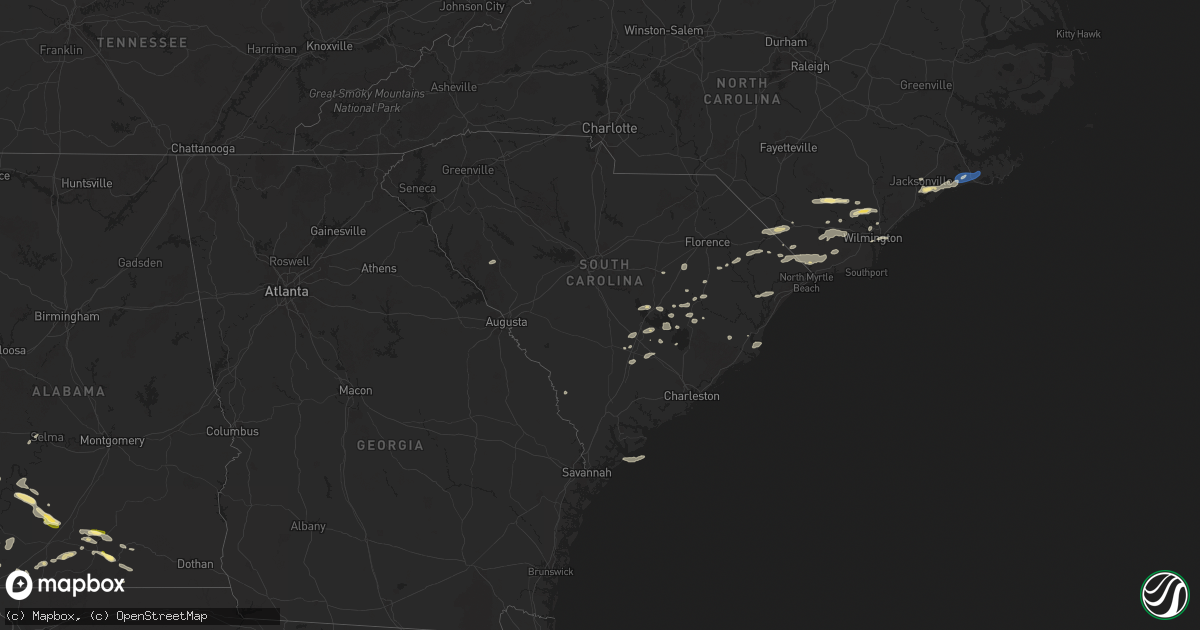
Hail Map in South Carolina on June 8, 2025
Get this storm
June 8 map
$229
one time, instant access
Download today. No call, no setup
Keep the $229
Bought the map and want the full workflow? Apply the entire $229 to a subscription within 7 days. None of it is wasted.
Every map, not just this one
This buys you this map. Subscription and you get every map we run, in the markets you choose from a few cities to whole states to nationwide. Plus real-time alerts the moment a storm fires.
Contact data
Name, contact info, occupancy, even credit band for addresses in the footprint. You go from where it hit to who to call.
Become the source they trust
Unlimited branding weather history reports on demand. You already have the documented answer ready for the property owner, and you are the one who showed up with it.
Property data and RoofTrace estimates
Pull up any address you have got, its value and the exact code rules for that jurisdiction, straight from One Click Code. Then RoofTrace estimates the squares, pitch, and roof value, priced the way you price.
Storm reports in South Carolina
South Carolina
| Date | Description |
|---|---|
| 06/08/20251:54 PM CDT | Tree reported down on green pond hwy and clover hill rd. Time estimated from radar. |
| 06/08/202512:50 PM CDT | Large branches down on power lines along paris lane |
| 06/08/202512:50 PM CDT | Tree down on pennyroyal rd near mineral place. |
| 06/08/202512:42 PM CDT | Tree reported down along highway 17 at sam thompson drive. Time estimated from radar. |
| 06/08/202512:39 PM CDT | Tree down along highway 17 near steed creek. Time estimated from radar. |
| 06/08/202512:30 PM CDT | Tree down on cumbee rd. |
| 06/08/202512:29 PM CDT | Tree reported down along highway 17 near combahee road. Time estimated from radar. |
| 06/08/202512:27 PM CDT | Tree reported down on bethera road near ackerman road. Time estimated from radar. |
| 06/08/202512:27 PM CDT | Powerlines reported down along hoover ave at berkeley street. Time estimated from radar. |
| 06/08/202512:20 PM CDT | Tree down blocking sc-19 near liner road in nichols. Time estimated based on radar. |
| 06/08/202512:15 PM CDT | Tree down on road in loris. |
| 06/08/202512:12 PM CDT | Tree reported down on power line along the 1900 block of summers drive. Time estimated from radar. |
| 06/08/202512:09 PM CDT | Tree reported down on trotters lane. Time estimated from radar. |
| 06/08/202512:09 PM CDT | Trees reported down on power lines in the 100 block of w main street. Time estiamted from radar. |
| 06/08/202512:00 PM CDT | Tree reported down on main street. Time estimated from radar. |
| 06/08/202512:00 PM CDT | Trees reported down on powerlines along gum ave. Time estimated from radar. |
| 06/08/202511:55 AM CDT | Tree down on nesmith rd. |
| 06/08/202511:55 AM CDT | Tree down in roadway. |
| 06/08/202511:54 AM CDT | Powerlines reported down along ace basin parkway at ashepoo drive. Time estimated from radar. |
| 06/08/202511:54 AM CDT | Tree reported down on green pond hwy and clover hill rd. Time estimated from radar. Corrected for updated time. |
| 06/08/202511:51 AM CDT | Tree reported down along highway 17 near combahee road. Time estimated from radar. |
| 06/08/202511:51 AM CDT | Trees reported down on powerlines along state road at sheep island road. Time estimated from radar. |
| 06/08/202511:48 AM CDT | Tree reported down in the 8600 block of green pond highway... Likely from thunderstorm outflow. Time estimated from radar. |
| 06/08/202511:45 AM CDT | Tree reported down in the 200 block of gruber street. Time estimated from radar. |
| 06/08/202511:45 AM CDT | Tree reported down on a powerline in the 100 block of pendarvis circle. Time estimated from radar. |
| 06/08/202511:37 AM CDT | Tree reported down and blocking both lanes of state road at highway 311. Time estimated from radar. |
| 06/08/202511:25 AM CDT | Tree reported down onto a vehicle on highway 15n at duncan chapel road... No injuries. Time estimated from radar. |
| 06/08/202511:22 AM CDT | Tree reported down in the 1700 block of highway 15. Time estimated from radar. |
| 06/08/202511:22 AM CDT | Powerlines reported down along garris ave at till lane. Time estimated from radar. |
| 06/08/202511:22 AM CDT | Tree reported down in the 1700 block of h |
| 06/08/202511:19 AM CDT | Tree reported down along charleston highway at shannon loop. Time estimated from radar. |
| 06/08/202511:17 AM CDT | The sc dot webcam on i-95 near mile marker 93 shows trees down on the interstate blocking the road. Time estimated from radar. |
| 06/08/202511:16 AM CDT | Tree reported down in the 15000 block of sniders highway... Likely due to thunderstorm outflow. Time estimated from radar. |
| 06/08/202511:13 AM CDT | Hail estimated at nickel to quarter size briefly fell near this location. Time estimated based on radar. |
| 06/08/202511:13 AM CDT | Clarendon county em relayed a picture of approximately quarter sized hail in the wyboo neighborhood. Time estimated by radar. |
| 06/08/202511:07 AM CDT | Multiple trees reported down along highway 321 just outside of estill. Time estimated from radar. |
| 06/08/202510:20 AM CDT | Spotter reports a small tree down across sc 261 near dalzell... Sc. |
| 06/08/202510:06 AM CDT | Sc dot reports trees down on us 601 near the intersection with garners ferry rd. Time estimated from radar. |
| 06/08/20259:55 AM CDT | Key net controller shared a picture of a large tree blocking the exit to a cul-de-sac on the 4200 block of devine street. Time estimated by radar. |
| 06/08/20259:38 AM CDT | Broadcast media relayed a picture of a tree down on the 900 block of tara trail causing minor damage to the property. Time estimated by radar. |
| 06/08/20258:37 AM CDT | Edgefield county dispatch reports trees down on gilgal rd. Time estimated from radar. |
All States Impacted by Hail Map on June 8, 2025
Cities Impacted by Hail Map on June 8, 2025
- Snyder, TX
- Jayton, TX
- Girard, TX
- Rotan, TX
- Crosbyton, TX
- Hamlin, TX
- Sylvester, TX
- Roby, TX
- McCaulley, TX
- Troy, SC
- Bradley, SC
- Ninety Six, SC
- Dickens, TX
- Merkel, TX
- Anson, TX
- Summerton, SC
- Pinewood, SC
- Elloree, SC
- Bowman, SC
- Luray, SC
- Lynchburg, SC
- Manning, SC
- Saint George, SC
- Silverton, TX
- Holly Hill, SC
- Vance, SC
- Perryton, TX
- Reevesville, SC
- Lockney, TX
- Dorchester, SC
- Eutawville, SC
- Kingstree, SC
- Salters, SC
- Greeleyville, SC
- Lane, SC
- Sweet Water, AL
- Quitaque, TX
- Cross, SC
- Matador, TX
- Scranton, SC
- Turkey, TX
- Flomot, TX
- Ridgeville, SC
- Gresham, SC
- Marion, SC
- Pamplico, SC
- Dixons Mills, AL
- Chadbourn, NC
- Magnolia, AL
- Linden, AL
- Fair Bluff, NC
- Clarkton, NC
- Elizabethtown, NC
- Mullins, SC
- Nichols, SC
- Cerro Gordo, NC
- Pine Hill, AL
- Thomasville, AL
- Arlington, AL
- Whiteville, NC
- Kelly, NC
- Council, NC
- Clarendon, TX
- Georgetown, SC
- Ivanhoe, NC
- Loris, SC
- Green Sea, SC
- Fort Stewart, GA
- Tabor City, NC
- Conway, SC
- Atkinson, NC
- Currie, NC
- Coy, AL
- Longs, SC
- Nakina, NC
- Bolton, NC
- Paducah, TX
- Lake Waccamaw, NC
- Camden, AL
- Rocky Point, NC
- Burgaw, NC
- Ash, NC
- Beatrice, AL
- Riegelwood, NC
- Delco, NC
- Vredenburgh, AL
- Longwood, NC
- Childress, TX
- Castle Hayne, NC
- Kenton, OK
- Elkhart, KS
- Goodwell, OK
- Supply, NC
- Waynesville, GA
- Waverly, GA
- Jacksonville, NC
- Hilton Head Island, SC
- Wilmington, NC
- Pine Apple, AL
- Crowell, TX
- Peterman, AL
- Evergreen, AL
- New Zion, SC
- Pinopolis, SC
- Camp Lejeune, NC
- Liberal, KS
- Pineville, SC
- Hugoton, KS
- Hubert, NC
- Boise City, OK
- McKenzie, AL
- Stella, NC
- Swansboro, NC
- Newport, NC
- Garnett, KS
- Wrightsville Beach, NC
- Hooker, OK
- Centerville, KS
- Blue Mound, KS
- Dozier, AL
- Greenville, AL
- Red Level, AL
- Waynoka, OK
- Mooreland, OK
- Georgiana, AL
- Guymon, OK
- Tyrone, OK
- Alva, OK
- Felt, OK
- Wellington, TX
- Memphis, TX
- Harrisburg, MO
- Mound City, KS
- Mapleton, KS
- Dodson, TX
- Hollis, OK
- Maple Park, IL
- Elburn, IL
- Jet, OK
- Cimarron, KS
- Dekalb, IL
- Columbia, MO
- Cherokee, OK
- Geneva, IL
- Batavia, IL
- North Aurora, IL
- Mooseheart, IL
- Wilson, KS
- Uniontown, KS
- Redfield, KS
- Andalusia, AL
- Fulton, KS
- Dorrance, KS
- Spearville, KS
- Monterey, LA
- Moreauville, LA
- Lettsworth, LA
- Turpin, OK
- Sugar Grove, IL
- Moran, KS
- Wakita, OK
- Nash, OK
- Lake City, SC
- Sumter, SC
- Prescott, KS
- Fort Scott, KS
- Warrenville, IL
- Aurora, IL
- West Chicago, IL
- Naperville, IL
- Winfield, IL
- Claude, TX
- Wheaton, IL
- Medford, OK
- Winfield, KS
- Ellsworth, KS
- Longton, KS
- Dexter, KS
- Butler, MO
- Angola, LA
- Woodville, MS
- Cedar Vale, KS
- Bronson, KS
- Fredonia, KS
- Saint Francisville, LA
- Carmen, OK
- Dodge City, KS
- Elk City, KS
- Mount Hermon, LA
- Franklinton, LA
- Neodesha, KS
- Divide, CO
- Woodland Park, CO
- Dalhart, TX
- Pond Creek, OK
- Woodridge, IL
- Downers Grove, IL
- Lisle, IL
- Westmont, IL
- Glen Ellyn, IL
- Helena, OK
- Montrose, MO
- Saint Charles, IL
- Sedan, KS
- Chipley, FL
- Diana, TX
- Longview, TX
- Opp, AL
- Wasco, IL
- Urich, MO
- Green Mountain Falls, CO
- Cascade, CO
- Pollock, LA
- Ensign, KS
- Clinton, MO
- Stark, KS
- Elba, AL
- Hallsville, TX
- Tallula, IL
- Ashland, IL
- Pleasant Plains, IL
- Gilmer, TX
- Fort Davis, TX
- Mansura, LA
- Hessmer, LA
- Chanute, KS
- Texline, TX
- La Grange, IL
- Clarendon Hills, IL
- Hinsdale, IL
- Willowbrook, IL
- Justice, IL
- Darien, IL
- Western Springs, IL
- Hickory Hills, IL
- Bridgeview, IL
- Willow Springs, IL
- Summit Argo, IL
- Stinnett, TX
- Morse, TX
- Balko, OK
- Honey Grove, TX
- Petty, TX
- Deepwater, MO
- Sunray, TX
- Panhandle, TX
- Springfield, IL
- Cantrall, IL
- Farlington, KS
- Arcadia, KS
- Petersburg, IL
- Leland, NC
- Kinston, AL
- Hepler, KS
- Garland, KS
- Alpine, TX
- Cottonport, LA
- Cambridge, KS
- Caldwell, KS
- Borger, TX
- Nardin, OK
- Tonkawa, OK
- Blackwell, OK
- Lamont, OK
- Deer Creek, OK
- South Haven, KS
- Braman, OK
- Savonburg, KS
- Independence, KS
- Samson, AL
- Manchester, OK
- Maple City, KS
- Newkirk, OK
- Marshall, TX
- Tatum, TX
- Strawn, TX
- Arma, KS
- Kanopolis, KS
- Kaw City, OK
- Booker, TX
- Ben Franklin, TX
- Roxton, TX
- Shidler, OK
- Pawhuska, OK
- Girard, KS
- Mulberry, KS
- Beckville, TX
- Brookville, KS
- Gordon, TX
- Chester, OK
- Longdale, OK
- Seiling, OK
- Pampa, TX
- Miami, TX
- Fairview, OK
- Skellytown, TX
- Marathon, TX
- Ponca City, OK
- Burbank, OK
- Geuda Springs, KS
- Arkansas City, KS
- Simmesport, LA
- Pittsburg, KS
- White Deer, TX
- Marksville, LA
- Wiggins, MS
- Spearman, TX
- Coffeyville, KS
- Plaucheville, LA
- Franklin, KS
- Frontenac, KS
- Batchelor, LA
- Palo Pinto, TX
- Wheeler, TX
- Sweetwater, OK
- Carthage, TX
- Long Branch, TX
- Gary, TX
- Asbury, MO
- Weir, KS
- S Coffeyville, OK
- Wann, OK
- Groom, TX
- Fort Stockton, TX
- Oronogo, MO
- Webb City, MO
- Carl Junction, MO
- Timpson, TX
- Tenaha, TX
- Jasper, MO
- Columbus, KS
- Ranger, TX
- Lenapah, OK
- Canton, OK
- Scammon, KS
- Galena, KS
- Hartley, TX
- Lakeview, TX
- Shawano, WI
- Cheyenne, OK
- Yeso, NM
- Westcliffe, CO
- Watonga, OK
- Lucedale, MS
- Vici, OK
- Delaware, OK
- Champlain, VA
- Warsaw, VA
- Burden, KS
- Ladonia, TX
- Center, TX
- Stephenville, TX
- Santo, TX
- Lipan, TX
- Mutual, OK
- Denton, TX
- Lake Dallas, TX
- Grenola, KS
- Canadian, TX
- Big Island, VA
- Pound, WI
- Suring, WI
- Mingus, TX
- Joplin, MO
- Bluff Dale, TX
- Fort Sumner, NM
- Henderson, TX
- Adrian, MO
- Warrensburg, MO
- Riverton, KS
- Garden City, MO
- Leeton, MO
- Creighton, MO
- Knob Noster, MO
- Baxter Springs, KS
- Copan, OK
- Bartlesville, OK
- Mcadoo, TX
- Howard, KS
- Moline, KS
- Seneca, MO
- Quapaw, OK
- Cee Vee, TX
- Tell, TX
- Green Ridge, MO
- Cooper, TX
- Oakwood, OK
- Sayre, OK
- Pecan Gap, TX
- Okeene, OK
- Windsor, MO
- Reydon, OK
- Elk Falls, KS
- Crane, TX
- Gladstone, NM
- Springer, NM
- Opolis, KS
- Mclean, TX
- Fay, OK
- San Augustine, TX
- Fall River, KS
- Walnut Springs, TX
- Thomas, OK
- Arapaho, OK
- Weatherford, OK
- Taloga, OK
- Geary, OK
- Custer City, OK
- Wetmore, CO
- Fritch, TX
- Citronelle, AL
- Sedan, NM
- Skiatook, OK
- Gardner, CO
- Clinton, OK
- Butler, OK
- Elk City, OK
- Hammon, OK
- Putnam, OK
- Canute, OK
- Hobart, OK
- Rocky, OK
- Gotebo, OK
- Sentinel, OK
- Cordell, OK
- Corn, OK
- Dill City, OK
- Foss, OK
- Bessie, OK
- Leedey, OK
- Carter, OK
- Ralls, TX
- Justiceburg, TX
- Post, TX
- Spur, TX
- Greenfield, OK
- Calumet, OK
- McIntosh, AL
- Amelia Court House, VA
- Brewton, AL
- Severy, KS
- Hydro, OK
- Odessa, TX
- Franktown, CO
- Elizabeth, CO
- Midland, TX
- Vega, TX
- Gainestown, AL
- Ore City, TX
- Appleton City, MO
- Rockville, MO
- Castleberry, AL
- Des Moines, NM
- Channing, TX
- Hinton, OK
- Osceola, MO
- Garrison, TX
- Elbert, CO
- Jackson, AL
- Bronson, TX
- Republic, MI
- Champion, MI
- Montpelier, VA
- Seymour, TX
- Bonham, TX
- Pineland, TX
- Broaddus, TX
- Windom, TX
- Dodd City, TX
- Chelsea, OK
- Adair, OK
- Broken Arrow, OK
- Inola, OK
- Claremore, OK
- Pryor, OK
- Oologah, OK
- Catoosa, OK
- Collinsville, OK
- Benjamin, TX
- Stanton, TX
- Garden City, TX
- Barnsdall, OK
- Ramona, OK
- Vera, OK
- Talala, OK
- Wynona, OK
- Munday, TX
- Goree, TX
- Ochelata, OK
- Sperry, OK
- Tulsa, OK
- Owasso, OK
- Chouteau, OK
- Locust Grove, OK
- Spavinaw, OK
- Salina, OK
- Strang, OK
- Rose, OK
- Big Cabin, OK
- Amarillo, TX
- Hedley, TX
- Atmore, AL
- Wagarville, AL
- Glen Allen, VA
- Ashland, VA
- Doswell, VA
- Little River, AL
- Tolar, TX
- Brookeland, TX
- Big Spring, TX
- Aspermont, TX
- Rolla, MO
- Laurel Hill, FL
- Quincy, MO
- Florala, AL
- La Harpe, KS
- Steelville, MO
- Roswell, NM
- Jasper, TX
- Salem, MO
- Coahoma, TX
- Hereford, TX
- Broadview, NM
- Sullivan, MO
- Versailles, MO
- Gravois Mills, MO
- Barnett, MO
- Frisco City, AL
- Collins, MO
- Bunkie, LA
- Walsenburg, CO
- Westbrook, TX
- Rocky Mount, MO
- Eldon, MO
- Tuttle, OK
- Minco, OK
- Union City, OK
- Mustang, OK
- Blanchard, OK
- Rochester, TX
- Capulin, NM
- Masterson, TX
- Mount Vernon, TX
- Licking, MO
- Weaubleau, MO
- Wheatland, MO
- Hemphill, TX
- Davisville, MO
- Knox City, TX
- Weinert, TX
- Throckmorton, TX
- O'Brien, TX
- Colorado City, TX
- Folsom, NM
- Haskell, TX
- Sweetwater, TX
- Calera, OK
- Cartwright, OK
- Tuscumbia, MO
- Defuniak Springs, FL
- Mount Pleasant, TX
- Wynnewood, OK
- Wiergate, TX
- Rule, TX
- Hico, TX
- Cadet, MO
- Mineral Point, MO
- Wayside, TX
- Henrico, VA
- Jefferson, TX
- Newcastle, OK
- Lueders, TX
- Stamford, TX
- Albany, TX
- Avoca, TX
- Woodson, TX
- Trent, TX
- Davis, OK
- Glen Rose, TX
- Tishomingo, OK
- Pittsburg, TX
- Hawley, TX
- Springer, OK
- Ratliff City, OK
- Hennepin, OK
- Healdton, OK
- Graham, OK
- Wilson, OK
- Ardmore, OK
- Lone Grove, OK
- Madill, OK
- Mannsville, OK
- Overbrook, OK
- Marietta, OK
- Burneyville, OK
- Muenster, TX
- Leon, OK
- Saint Jo, TX
- Ringling, OK
- Happy, TX
- Henley, MO
- Eugene, MO
- Archie, MO
- Hart, TX
- Pauls Valley, OK
- Harrisonville, MO
- Buffalo, KS
- Gainesville, TX
- Thackerville, OK
- Abilene, TX
- Newcastle, TX
- Graham, TX
- Breckenridge, TX
- Kingston, OK
- Mead, OK
- Lebanon, OK
- Whitesboro, TX
- Lindsay, TX
- Valley View, TX
- Saint Elizabeth, MO
- Harleton, TX
- Loraine, TX
- Atoka, OK
- Jay, FL
- Avinger, TX
- Tulia, TX
- Moran, TX
- Water View, VA
- Kaiser, MO
- Iola, KS
- Walnut, KS
- Bunker, MO
- Toronto, KS
- Coyanosa, TX
- Roaring Springs, TX
- Hendrix, OK
- Colbert, OK
- Durant, OK
- Pottsboro, TX
- Denison, TX
- Collinsville, TX
- Howe, TX
- Sherman, TX
- Sadler, TX
- Pilot Point, TX
- Tioga, TX
- Gunter, TX
- Osage Beach, MO
- Sunrise Beach, MO
- Milton, FL
- Clayton, NM
- Caddo, TX
- Cisco, TX
- Whitewright, TX
- Celina, TX
- Van Alstyne, TX
- Anna, TX
- Era, TX
- Sanger, TX
- Aubrey, TX
- Savoy, TX
- Bells, TX
- Ravenna, TX
- Ellington, MO
- Edgar Springs, MO
- Kress, TX
- Leasburg, MO
- Plainview, TX
- Centerville, MO
- Petersburg, TX
- Floydada, TX
- Lorenzo, TX
- Bixby, MO
- Lane, OK
- Latham, KS
- Brownfield, TX
- Afton, TX
- Holt, FL
- Argyle, TX
- Prosper, TX
- Flower Mound, TX
- Little Elm, TX
- Frisco, TX
- Lewisville, TX
- Krum, TX
- Ponder, TX
- Montague, TX
- Rosston, TX
- Forestburg, TX
- Decatur, TX
- Nocona, TX
- Terral, OK
- Ryan, OK
- Ringgold, TX
- Mckinney, TX
- Trenton, TX
- Princeton, TX
- Blue Ridge, TX
- Celeste, TX
- Wolfe City, TX
- Farmersville, TX
- Leonard, TX
- Bailey, TX
- Melissa, TX
- The Colony, TX
- Randolph, TX
- Ector, TX
- Tahoka, TX
- Boss, MO
- Tye, TX
- Kenefic, OK
- Caddo, OK
- Odonnell, TX
- Caulfield, MO
- Bison, OK
- Clyde, TX
- Wilson, TX
- Charlotte Court House, VA
- Pamplin, VA
- Dora, MO
- West Plains, MO
- Stringtown, OK
- Boswell, OK
- Bennington, OK
- Talco, TX
- Willow Springs, MO
- Dyess Afb, TX
- Seagraves, TX
- Pottersville, MO
- Baird, TX
- Waurika, OK
- Loop, TX
- Welch, TX
- Lamesa, TX
- Gail, TX
- Bogata, TX
- Clarksville, TX
- Mineral Wells, TX
- South Bend, TX
- Weatherford, TX
- Graford, TX
- Millsap, TX
- Granbury, TX
- Southlake, TX
- Bedford, TX
- Addison, TX
- Roanoke, TX
- Allen, TX
- Fort Worth, TX
- Dallas, TX
- Richardson, TX
- Grapevine, TX
- Irving, TX
- Euless, TX
- Colleyville, TX
- Coppell, TX
- Carrollton, TX
- Wylie, TX
- Arlington, TX
- Plano, TX
- Garland, TX
- Sachse, TX
- Nevada, TX
- Greenville, TX
- Grand Prairie, TX
- Lavon, TX
- Caddo Mills, TX
- Rowlett, TX
- Hurst, TX
- Arthur City, TX
- Sumner, TX
- Powderly, TX
- Hugo, OK
- Paris, TX
- Telephone, TX
- Brookston, TX
- Rockwall, TX
- Commerce, TX
- Klondike, TX
- Royse City, TX
- Enloe, TX
- Duncanville, TX
- Campbell, TX
- Pattonville, TX
- Detroit, TX
- Blossom, TX
- Deport, TX
- Cumby, TX
- Lake Creek, TX
- Mesquite, TX
- Sulphur Springs, TX
- Sunnyvale, TX
- Lone Oak, TX
- Desoto, TX
- Alba, TX
- Seagoville, TX
- Balch Springs, TX
- Yantis, TX
- Pickton, TX
- Cedar Hill, TX
- Brashear, TX
- Emory, TX
- Quinlan, TX
- Hutchins, TX
- Forney, TX
- Terrell, TX
- Crandall, TX
- Fruitvale, TX
- Saltillo, TX
- Wills Point, TX
- Quitman, TX
- Sulphur Bluff, TX
- Lancaster, TX
- Point, TX
- Dike, TX
- Como, TX
- Edgewood, TX
- Wilmer, TX
- Kaufman, TX
- Grand Saline, TX
- Mineola, TX
- Sumrall, MS
- Columbia, MS
- Koshkonong, MO
- Mammoth Spring, AR
- Salem, AR
- Lake George, CO
- Isabella, OK
- Piedmont, KS
- Bassfield, MS
- Winona, MO
- Alton, MO
- Gould, OK
- Mangum, OK
- Canton, TX
- Tuscola, TX
- Van Buren, MO
- McCune, KS
- Omaha, TX
- Rising Star, TX
- Fremont, MO
- Cross Plains, TX
- Venus, TX
- Lillian, TX
- Mansfield, TX
- Cresson, TX
- Crowley, TX
- Midlothian, TX
- Cleburne, TX
- Alvarado, TX
- Aledo, TX
- Godley, TX
- Joshua, TX
- Burleson, TX
- Grandview, TX
- Hillsboro, TX
- Rio Vista, TX
- Itasca, TX
- Blum, TX
- Covington, TX
- Waxahachie, TX
- Maypearl, TX
- Keene, TX
- Hughes Springs, TX
- Scroggins, TX
- Cookville, TX
- Winnsboro, TX
- Winfield, TX
- Daingerfield, TX
- Naples, TX
- Leesburg, TX
- Lone Star, TX
- Tyler, TX
- Hawkins, TX
- Kemp, TX
- Van, TX
- Eustace, TX
- Winona, TX
- Scurry, TX
- Murchison, TX
- Athens, TX
- Lindale, TX
- Big Sandy, TX
- Ben Wheeler, TX
- Chandler, TX
- Ferris, TX
- Brownsboro, TX
- Mabank, TX
- Red Oak, TX
- Ennis, TX
- Palmer, TX
- Chatfield, TX
- Rosser, TX
- Flint, TX
- Malakoff, TX
- Taiban, NM
- Glenallen, MO
- Eastland, TX
- Eglin Afb, FL
- Bowie, TX
- Bellevue, TX
- Roscoe, TX
- Sunset, TX
- Grandin, MO
- Gorman, TX
- Carbon, TX
- Barry, TX
- Rice, TX
- Milford, TX
- Italy, TX
- Forreston, TX
- Corsicana, TX
- Frost, TX
- Blooming Grove, TX
- Bynum, TX
- Mertens, TX
- Purdon, TX
- Pomona, MO
- Lumberton, MS
- Jackson, MO
- Cape Girardeau, MO
- Kilgore, TX
- Karnack, TX
- Gladewater, TX
- White Oak, TX
- Arp, TX
- Overton, TX
- Laneville, TX
- Selman City, TX
- Mount Enterprise, TX
- Troup, TX
- Price, TX
- Whitehouse, TX
- Nolan, TX
- Purvis, MS
- Blackwell, TX
- Wingate, TX
- De Leon, TX
- Desdemona, TX
- Burkett, TX
- Winters, TX
- Ovalo, TX
- Flomaton, AL
- Dublin, TX
- Comanche, TX
- May, TX
- Buffalo Gap, TX
- Brownwood, TX
- Lawn, TX
- Goldsboro, TX
- Novice, TX
- Coleman, TX
- Talpa, TX
- Valera, TX
- Milburn, OK
- Sidney, TX
- Uriah, AL
- Chico, TX
- Elmore City, OK
- Stockton, AL
- Ballinger, TX
- Dawson, TX
- Richland, TX
- Malone, TX
- Streetman, TX
- Kerens, TX
- Hubbard, TX
- Wortham, TX
- Waskom, TX
- De Berry, TX
- Poplar Bluff, MO
- Williamsville, MO
- Ellsinore, MO
- Harviell, MO
- Dudley, MO
- Fisk, MO
- Broseley, MO
- Bernie, MO
- Dexter, MO
- Puxico, MO
- Bloomfield, MO
- Wappapello, MO
- Essex, MO
- Voss, TX
- Gouldbusk, TX
- Santa Anna, TX
- Maysville, OK
- Lindsay, OK
- Baker, FL
- Bangs, TX
- Rockwood, TX
- Sunflower, AL
- Rochelle, TX
- Brookesmith, TX
- Richland Springs, TX
- Mullin, TX
- San Saba, TX
- Pottsville, TX
- Sulphur, OK
- Dimmitt, TX
- Steamboat Springs, CO
- Slaton, TX
- Lubbock, TX
- Hayden, CO
- Canton, MS
- Calvert, TX
- Ransom Canyon, TX
- Metropolis, IL
- Grand Chain, IL
- Kevil, KY
- Tamms, IL
- Thebes, IL
- Olive Branch, IL
- Miller City, IL
- La Center, KY
- Barlow, KY
- Pulaski, IL
- Ullin, IL
- Demopolis, AL
- Scott City, MO
- Cairo, IL
- Karnak, IL
- Mounds, IL
- Villa Ridge, IL
- Olmsted, IL
- Gallion, AL
- Orrville, AL
- Marion Junction, AL
- Collins, GA
- Rich Hill, MO


