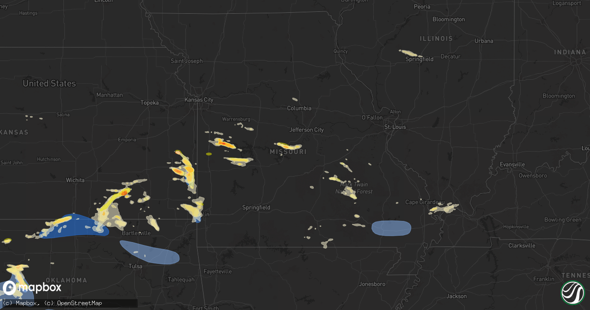
Hail Map in Missouri on June 8, 2025
Get this storm
June 8 map
$229
one time, instant access
Download today. No call, no setup
Keep the $229
Bought the map and want the full workflow? Apply the entire $229 to a subscription within 7 days. None of it is wasted.
Every map, not just this one
This buys you this map. Subscription and you get every map we run, in the markets you choose from a few cities to whole states to nationwide. Plus real-time alerts the moment a storm fires.
Contact data
Name, contact info, occupancy, even credit band for addresses in the footprint. You go from where it hit to who to call.
Become the source they trust
Unlimited branding weather history reports on demand. You already have the documented answer ready for the property owner, and you are the one who showed up with it.
Property data and RoofTrace estimates
Pull up any address you have got, its value and the exact code rules for that jurisdiction, straight from One Click Code. Then RoofTrace estimates the squares, pitch, and roof value, priced the way you price.
Storm reports in Missouri
Missouri
| Date | Description |
|---|---|
| 06/08/20255:56 PM CDT | Emergency manager relayed report of quarter hail just north of rich hill along i49. |
| 06/08/20255:38 PM CDT | Report via social media of a tree down over the road. Time estimated via radar. |
| 06/08/20255:25 PM CDT | Delayed report through contact. Numerous large trees blown over. |
| 06/08/20253:58 PM CDT | Social media report. |
| 06/08/20253:44 PM CDT | Emergency manager relayed photo of measured hail between 2 and 2.5 inches. |
| 06/08/20253:32 PM CDT | Emergency manager relayed photo of quarter to half dollar sized hail in the unincorporated town of germantown. |
| 06/08/20253:32 PM CDT | A local report indicates 1.00 inch wind near 3 NW Montrose |
| 06/08/20253:30 PM CDT | Social media report. |
| 06/08/20253:29 PM CDT | Emergency manager relayed pictures of large hail nw of montrose. Time estimated from radar. |
| 06/08/20253:28 PM CDT | Social media report. |
| 06/08/20253:25 PM CDT | Social media picture east of ballard. |
| 06/08/202512:50 AM CDT | Poplar bluff asos. |
| 06/08/202512:50 AM CDT | P |
| 06/07/20258:09 PM CDT | Photo from social media of several stones between half dollar and golf ball size hail. Large volume of hail reported within the storm... With missouri state highway pat |
| 06/07/20258:06 PM CDT | Hail reported to cover the ground. |
| 06/07/20258:02 PM CDT | Report from mping - quarter 1.00 in. |
| 06/07/20257:32 PM CDT | A local report indicates 1.00 inch wind near Steelville |
| 06/07/20257:15 PM CDT | Picture of hail just larger than quarter size in osceola. |
All States Impacted by Hail Map on June 8, 2025
Cities Impacted by Hail Map on June 8, 2025
- Snyder, TX
- Jayton, TX
- Girard, TX
- Rotan, TX
- Crosbyton, TX
- Hamlin, TX
- Sylvester, TX
- Roby, TX
- McCaulley, TX
- Troy, SC
- Bradley, SC
- Ninety Six, SC
- Dickens, TX
- Merkel, TX
- Anson, TX
- Summerton, SC
- Pinewood, SC
- Elloree, SC
- Bowman, SC
- Luray, SC
- Lynchburg, SC
- Manning, SC
- Saint George, SC
- Silverton, TX
- Holly Hill, SC
- Vance, SC
- Perryton, TX
- Reevesville, SC
- Lockney, TX
- Dorchester, SC
- Eutawville, SC
- Kingstree, SC
- Salters, SC
- Greeleyville, SC
- Lane, SC
- Sweet Water, AL
- Quitaque, TX
- Cross, SC
- Matador, TX
- Scranton, SC
- Turkey, TX
- Flomot, TX
- Ridgeville, SC
- Gresham, SC
- Marion, SC
- Pamplico, SC
- Dixons Mills, AL
- Chadbourn, NC
- Magnolia, AL
- Linden, AL
- Fair Bluff, NC
- Clarkton, NC
- Elizabethtown, NC
- Mullins, SC
- Nichols, SC
- Cerro Gordo, NC
- Pine Hill, AL
- Thomasville, AL
- Arlington, AL
- Whiteville, NC
- Kelly, NC
- Council, NC
- Clarendon, TX
- Georgetown, SC
- Ivanhoe, NC
- Loris, SC
- Green Sea, SC
- Fort Stewart, GA
- Tabor City, NC
- Conway, SC
- Atkinson, NC
- Currie, NC
- Coy, AL
- Longs, SC
- Nakina, NC
- Bolton, NC
- Paducah, TX
- Lake Waccamaw, NC
- Camden, AL
- Rocky Point, NC
- Burgaw, NC
- Ash, NC
- Beatrice, AL
- Riegelwood, NC
- Delco, NC
- Vredenburgh, AL
- Longwood, NC
- Childress, TX
- Castle Hayne, NC
- Kenton, OK
- Elkhart, KS
- Goodwell, OK
- Supply, NC
- Waynesville, GA
- Waverly, GA
- Jacksonville, NC
- Hilton Head Island, SC
- Wilmington, NC
- Pine Apple, AL
- Crowell, TX
- Peterman, AL
- Evergreen, AL
- New Zion, SC
- Pinopolis, SC
- Camp Lejeune, NC
- Liberal, KS
- Pineville, SC
- Hugoton, KS
- Hubert, NC
- Boise City, OK
- McKenzie, AL
- Stella, NC
- Swansboro, NC
- Newport, NC
- Garnett, KS
- Wrightsville Beach, NC
- Hooker, OK
- Centerville, KS
- Blue Mound, KS
- Dozier, AL
- Greenville, AL
- Red Level, AL
- Waynoka, OK
- Mooreland, OK
- Georgiana, AL
- Guymon, OK
- Tyrone, OK
- Alva, OK
- Felt, OK
- Wellington, TX
- Memphis, TX
- Harrisburg, MO
- Mound City, KS
- Mapleton, KS
- Dodson, TX
- Hollis, OK
- Maple Park, IL
- Elburn, IL
- Jet, OK
- Cimarron, KS
- Dekalb, IL
- Columbia, MO
- Cherokee, OK
- Geneva, IL
- Batavia, IL
- North Aurora, IL
- Mooseheart, IL
- Wilson, KS
- Uniontown, KS
- Redfield, KS
- Andalusia, AL
- Fulton, KS
- Dorrance, KS
- Spearville, KS
- Monterey, LA
- Moreauville, LA
- Lettsworth, LA
- Turpin, OK
- Sugar Grove, IL
- Moran, KS
- Wakita, OK
- Nash, OK
- Lake City, SC
- Sumter, SC
- Prescott, KS
- Fort Scott, KS
- Warrenville, IL
- Aurora, IL
- West Chicago, IL
- Naperville, IL
- Winfield, IL
- Claude, TX
- Wheaton, IL
- Medford, OK
- Winfield, KS
- Ellsworth, KS
- Longton, KS
- Dexter, KS
- Butler, MO
- Angola, LA
- Woodville, MS
- Cedar Vale, KS
- Bronson, KS
- Fredonia, KS
- Saint Francisville, LA
- Carmen, OK
- Dodge City, KS
- Elk City, KS
- Mount Hermon, LA
- Franklinton, LA
- Neodesha, KS
- Divide, CO
- Woodland Park, CO
- Dalhart, TX
- Pond Creek, OK
- Woodridge, IL
- Downers Grove, IL
- Lisle, IL
- Westmont, IL
- Glen Ellyn, IL
- Helena, OK
- Montrose, MO
- Saint Charles, IL
- Sedan, KS
- Chipley, FL
- Diana, TX
- Longview, TX
- Opp, AL
- Wasco, IL
- Urich, MO
- Green Mountain Falls, CO
- Cascade, CO
- Pollock, LA
- Ensign, KS
- Clinton, MO
- Stark, KS
- Elba, AL
- Hallsville, TX
- Tallula, IL
- Ashland, IL
- Pleasant Plains, IL
- Gilmer, TX
- Fort Davis, TX
- Mansura, LA
- Hessmer, LA
- Chanute, KS
- Texline, TX
- La Grange, IL
- Clarendon Hills, IL
- Hinsdale, IL
- Willowbrook, IL
- Justice, IL
- Darien, IL
- Western Springs, IL
- Hickory Hills, IL
- Bridgeview, IL
- Willow Springs, IL
- Summit Argo, IL
- Stinnett, TX
- Morse, TX
- Balko, OK
- Honey Grove, TX
- Petty, TX
- Deepwater, MO
- Sunray, TX
- Panhandle, TX
- Springfield, IL
- Cantrall, IL
- Farlington, KS
- Arcadia, KS
- Petersburg, IL
- Leland, NC
- Kinston, AL
- Hepler, KS
- Garland, KS
- Alpine, TX
- Cottonport, LA
- Cambridge, KS
- Caldwell, KS
- Borger, TX
- Nardin, OK
- Tonkawa, OK
- Blackwell, OK
- Lamont, OK
- Deer Creek, OK
- South Haven, KS
- Braman, OK
- Savonburg, KS
- Independence, KS
- Samson, AL
- Manchester, OK
- Maple City, KS
- Newkirk, OK
- Marshall, TX
- Tatum, TX
- Strawn, TX
- Arma, KS
- Kanopolis, KS
- Kaw City, OK
- Booker, TX
- Ben Franklin, TX
- Roxton, TX
- Shidler, OK
- Pawhuska, OK
- Girard, KS
- Mulberry, KS
- Beckville, TX
- Brookville, KS
- Gordon, TX
- Chester, OK
- Longdale, OK
- Seiling, OK
- Pampa, TX
- Miami, TX
- Fairview, OK
- Skellytown, TX
- Marathon, TX
- Ponca City, OK
- Burbank, OK
- Geuda Springs, KS
- Arkansas City, KS
- Simmesport, LA
- Pittsburg, KS
- White Deer, TX
- Marksville, LA
- Wiggins, MS
- Spearman, TX
- Coffeyville, KS
- Plaucheville, LA
- Franklin, KS
- Frontenac, KS
- Batchelor, LA
- Palo Pinto, TX
- Wheeler, TX
- Sweetwater, OK
- Carthage, TX
- Long Branch, TX
- Gary, TX
- Asbury, MO
- Weir, KS
- S Coffeyville, OK
- Wann, OK
- Groom, TX
- Fort Stockton, TX
- Oronogo, MO
- Webb City, MO
- Carl Junction, MO
- Timpson, TX
- Tenaha, TX
- Jasper, MO
- Columbus, KS
- Ranger, TX
- Lenapah, OK
- Canton, OK
- Scammon, KS
- Galena, KS
- Hartley, TX
- Lakeview, TX
- Shawano, WI
- Cheyenne, OK
- Yeso, NM
- Westcliffe, CO
- Watonga, OK
- Lucedale, MS
- Vici, OK
- Delaware, OK
- Champlain, VA
- Warsaw, VA
- Burden, KS
- Ladonia, TX
- Center, TX
- Stephenville, TX
- Santo, TX
- Lipan, TX
- Mutual, OK
- Denton, TX
- Lake Dallas, TX
- Grenola, KS
- Canadian, TX
- Big Island, VA
- Pound, WI
- Suring, WI
- Mingus, TX
- Joplin, MO
- Bluff Dale, TX
- Fort Sumner, NM
- Henderson, TX
- Adrian, MO
- Warrensburg, MO
- Riverton, KS
- Garden City, MO
- Leeton, MO
- Creighton, MO
- Knob Noster, MO
- Baxter Springs, KS
- Copan, OK
- Bartlesville, OK
- Mcadoo, TX
- Howard, KS
- Moline, KS
- Seneca, MO
- Quapaw, OK
- Cee Vee, TX
- Tell, TX
- Green Ridge, MO
- Cooper, TX
- Oakwood, OK
- Sayre, OK
- Pecan Gap, TX
- Okeene, OK
- Windsor, MO
- Reydon, OK
- Elk Falls, KS
- Crane, TX
- Gladstone, NM
- Springer, NM
- Opolis, KS
- Mclean, TX
- Fay, OK
- San Augustine, TX
- Fall River, KS
- Walnut Springs, TX
- Thomas, OK
- Arapaho, OK
- Weatherford, OK
- Taloga, OK
- Geary, OK
- Custer City, OK
- Wetmore, CO
- Fritch, TX
- Citronelle, AL
- Sedan, NM
- Skiatook, OK
- Gardner, CO
- Clinton, OK
- Butler, OK
- Elk City, OK
- Hammon, OK
- Putnam, OK
- Canute, OK
- Hobart, OK
- Rocky, OK
- Gotebo, OK
- Sentinel, OK
- Cordell, OK
- Corn, OK
- Dill City, OK
- Foss, OK
- Bessie, OK
- Leedey, OK
- Carter, OK
- Ralls, TX
- Justiceburg, TX
- Post, TX
- Spur, TX
- Greenfield, OK
- Calumet, OK
- McIntosh, AL
- Amelia Court House, VA
- Brewton, AL
- Severy, KS
- Hydro, OK
- Odessa, TX
- Franktown, CO
- Elizabeth, CO
- Midland, TX
- Vega, TX
- Gainestown, AL
- Ore City, TX
- Appleton City, MO
- Rockville, MO
- Castleberry, AL
- Des Moines, NM
- Channing, TX
- Hinton, OK
- Osceola, MO
- Garrison, TX
- Elbert, CO
- Jackson, AL
- Bronson, TX
- Republic, MI
- Champion, MI
- Montpelier, VA
- Seymour, TX
- Bonham, TX
- Pineland, TX
- Broaddus, TX
- Windom, TX
- Dodd City, TX
- Chelsea, OK
- Adair, OK
- Broken Arrow, OK
- Inola, OK
- Claremore, OK
- Pryor, OK
- Oologah, OK
- Catoosa, OK
- Collinsville, OK
- Benjamin, TX
- Stanton, TX
- Garden City, TX
- Barnsdall, OK
- Ramona, OK
- Vera, OK
- Talala, OK
- Wynona, OK
- Munday, TX
- Goree, TX
- Ochelata, OK
- Sperry, OK
- Tulsa, OK
- Owasso, OK
- Chouteau, OK
- Locust Grove, OK
- Spavinaw, OK
- Salina, OK
- Strang, OK
- Rose, OK
- Big Cabin, OK
- Amarillo, TX
- Hedley, TX
- Atmore, AL
- Wagarville, AL
- Glen Allen, VA
- Ashland, VA
- Doswell, VA
- Little River, AL
- Tolar, TX
- Brookeland, TX
- Big Spring, TX
- Aspermont, TX
- Rolla, MO
- Laurel Hill, FL
- Quincy, MO
- Florala, AL
- La Harpe, KS
- Steelville, MO
- Roswell, NM
- Jasper, TX
- Salem, MO
- Coahoma, TX
- Hereford, TX
- Broadview, NM
- Sullivan, MO
- Versailles, MO
- Gravois Mills, MO
- Barnett, MO
- Frisco City, AL
- Collins, MO
- Bunkie, LA
- Walsenburg, CO
- Westbrook, TX
- Rocky Mount, MO
- Eldon, MO
- Tuttle, OK
- Minco, OK
- Union City, OK
- Mustang, OK
- Blanchard, OK
- Rochester, TX
- Capulin, NM
- Masterson, TX
- Mount Vernon, TX
- Licking, MO
- Weaubleau, MO
- Wheatland, MO
- Hemphill, TX
- Davisville, MO
- Knox City, TX
- Weinert, TX
- Throckmorton, TX
- O'Brien, TX
- Colorado City, TX
- Folsom, NM
- Haskell, TX
- Sweetwater, TX
- Calera, OK
- Cartwright, OK
- Tuscumbia, MO
- Defuniak Springs, FL
- Mount Pleasant, TX
- Wynnewood, OK
- Wiergate, TX
- Rule, TX
- Hico, TX
- Cadet, MO
- Mineral Point, MO
- Wayside, TX
- Henrico, VA
- Jefferson, TX
- Newcastle, OK
- Lueders, TX
- Stamford, TX
- Albany, TX
- Avoca, TX
- Woodson, TX
- Trent, TX
- Davis, OK
- Glen Rose, TX
- Tishomingo, OK
- Pittsburg, TX
- Hawley, TX
- Springer, OK
- Ratliff City, OK
- Hennepin, OK
- Healdton, OK
- Graham, OK
- Wilson, OK
- Ardmore, OK
- Lone Grove, OK
- Madill, OK
- Mannsville, OK
- Overbrook, OK
- Marietta, OK
- Burneyville, OK
- Muenster, TX
- Leon, OK
- Saint Jo, TX
- Ringling, OK
- Happy, TX
- Henley, MO
- Eugene, MO
- Archie, MO
- Hart, TX
- Pauls Valley, OK
- Harrisonville, MO
- Buffalo, KS
- Gainesville, TX
- Thackerville, OK
- Abilene, TX
- Newcastle, TX
- Graham, TX
- Breckenridge, TX
- Kingston, OK
- Mead, OK
- Lebanon, OK
- Whitesboro, TX
- Lindsay, TX
- Valley View, TX
- Saint Elizabeth, MO
- Harleton, TX
- Loraine, TX
- Atoka, OK
- Jay, FL
- Avinger, TX
- Tulia, TX
- Moran, TX
- Water View, VA
- Kaiser, MO
- Iola, KS
- Walnut, KS
- Bunker, MO
- Toronto, KS
- Coyanosa, TX
- Roaring Springs, TX
- Hendrix, OK
- Colbert, OK
- Durant, OK
- Pottsboro, TX
- Denison, TX
- Collinsville, TX
- Howe, TX
- Sherman, TX
- Sadler, TX
- Pilot Point, TX
- Tioga, TX
- Gunter, TX
- Osage Beach, MO
- Sunrise Beach, MO
- Milton, FL
- Clayton, NM
- Caddo, TX
- Cisco, TX
- Whitewright, TX
- Celina, TX
- Van Alstyne, TX
- Anna, TX
- Era, TX
- Sanger, TX
- Aubrey, TX
- Savoy, TX
- Bells, TX
- Ravenna, TX
- Ellington, MO
- Edgar Springs, MO
- Kress, TX
- Leasburg, MO
- Plainview, TX
- Centerville, MO
- Petersburg, TX
- Floydada, TX
- Lorenzo, TX
- Bixby, MO
- Lane, OK
- Latham, KS
- Brownfield, TX
- Afton, TX
- Holt, FL
- Argyle, TX
- Prosper, TX
- Flower Mound, TX
- Little Elm, TX
- Frisco, TX
- Lewisville, TX
- Krum, TX
- Ponder, TX
- Montague, TX
- Rosston, TX
- Forestburg, TX
- Decatur, TX
- Nocona, TX
- Terral, OK
- Ryan, OK
- Ringgold, TX
- Mckinney, TX
- Trenton, TX
- Princeton, TX
- Blue Ridge, TX
- Celeste, TX
- Wolfe City, TX
- Farmersville, TX
- Leonard, TX
- Bailey, TX
- Melissa, TX
- The Colony, TX
- Randolph, TX
- Ector, TX
- Tahoka, TX
- Boss, MO
- Tye, TX
- Kenefic, OK
- Caddo, OK
- Odonnell, TX
- Caulfield, MO
- Bison, OK
- Clyde, TX
- Wilson, TX
- Charlotte Court House, VA
- Pamplin, VA
- Dora, MO
- West Plains, MO
- Stringtown, OK
- Boswell, OK
- Bennington, OK
- Talco, TX
- Willow Springs, MO
- Dyess Afb, TX
- Seagraves, TX
- Pottersville, MO
- Baird, TX
- Waurika, OK
- Loop, TX
- Welch, TX
- Lamesa, TX
- Gail, TX
- Bogata, TX
- Clarksville, TX
- Mineral Wells, TX
- South Bend, TX
- Weatherford, TX
- Graford, TX
- Millsap, TX
- Granbury, TX
- Southlake, TX
- Bedford, TX
- Addison, TX
- Roanoke, TX
- Allen, TX
- Fort Worth, TX
- Dallas, TX
- Richardson, TX
- Grapevine, TX
- Irving, TX
- Euless, TX
- Colleyville, TX
- Coppell, TX
- Carrollton, TX
- Wylie, TX
- Arlington, TX
- Plano, TX
- Garland, TX
- Sachse, TX
- Nevada, TX
- Greenville, TX
- Grand Prairie, TX
- Lavon, TX
- Caddo Mills, TX
- Rowlett, TX
- Hurst, TX
- Arthur City, TX
- Sumner, TX
- Powderly, TX
- Hugo, OK
- Paris, TX
- Telephone, TX
- Brookston, TX
- Rockwall, TX
- Commerce, TX
- Klondike, TX
- Royse City, TX
- Enloe, TX
- Duncanville, TX
- Campbell, TX
- Pattonville, TX
- Detroit, TX
- Blossom, TX
- Deport, TX
- Cumby, TX
- Lake Creek, TX
- Mesquite, TX
- Sulphur Springs, TX
- Sunnyvale, TX
- Lone Oak, TX
- Desoto, TX
- Alba, TX
- Seagoville, TX
- Balch Springs, TX
- Yantis, TX
- Pickton, TX
- Cedar Hill, TX
- Brashear, TX
- Emory, TX
- Quinlan, TX
- Hutchins, TX
- Forney, TX
- Terrell, TX
- Crandall, TX
- Fruitvale, TX
- Saltillo, TX
- Wills Point, TX
- Quitman, TX
- Sulphur Bluff, TX
- Lancaster, TX
- Point, TX
- Dike, TX
- Como, TX
- Edgewood, TX
- Wilmer, TX
- Kaufman, TX
- Grand Saline, TX
- Mineola, TX
- Sumrall, MS
- Columbia, MS
- Koshkonong, MO
- Mammoth Spring, AR
- Salem, AR
- Lake George, CO
- Isabella, OK
- Piedmont, KS
- Bassfield, MS
- Winona, MO
- Alton, MO
- Gould, OK
- Mangum, OK
- Canton, TX
- Tuscola, TX
- Van Buren, MO
- McCune, KS
- Omaha, TX
- Rising Star, TX
- Fremont, MO
- Cross Plains, TX
- Venus, TX
- Lillian, TX
- Mansfield, TX
- Cresson, TX
- Crowley, TX
- Midlothian, TX
- Cleburne, TX
- Alvarado, TX
- Aledo, TX
- Godley, TX
- Joshua, TX
- Burleson, TX
- Grandview, TX
- Hillsboro, TX
- Rio Vista, TX
- Itasca, TX
- Blum, TX
- Covington, TX
- Waxahachie, TX
- Maypearl, TX
- Keene, TX
- Hughes Springs, TX
- Scroggins, TX
- Cookville, TX
- Winnsboro, TX
- Winfield, TX
- Daingerfield, TX
- Naples, TX
- Leesburg, TX
- Lone Star, TX
- Tyler, TX
- Hawkins, TX
- Kemp, TX
- Van, TX
- Eustace, TX
- Winona, TX
- Scurry, TX
- Murchison, TX
- Athens, TX
- Lindale, TX
- Big Sandy, TX
- Ben Wheeler, TX
- Chandler, TX
- Ferris, TX
- Brownsboro, TX
- Mabank, TX
- Red Oak, TX
- Ennis, TX
- Palmer, TX
- Chatfield, TX
- Rosser, TX
- Flint, TX
- Malakoff, TX
- Taiban, NM
- Glenallen, MO
- Eastland, TX
- Eglin Afb, FL
- Bowie, TX
- Bellevue, TX
- Roscoe, TX
- Sunset, TX
- Grandin, MO
- Gorman, TX
- Carbon, TX
- Barry, TX
- Rice, TX
- Milford, TX
- Italy, TX
- Forreston, TX
- Corsicana, TX
- Frost, TX
- Blooming Grove, TX
- Bynum, TX
- Mertens, TX
- Purdon, TX
- Pomona, MO
- Lumberton, MS
- Jackson, MO
- Cape Girardeau, MO
- Kilgore, TX
- Karnack, TX
- Gladewater, TX
- White Oak, TX
- Arp, TX
- Overton, TX
- Laneville, TX
- Selman City, TX
- Mount Enterprise, TX
- Troup, TX
- Price, TX
- Whitehouse, TX
- Nolan, TX
- Purvis, MS
- Blackwell, TX
- Wingate, TX
- De Leon, TX
- Desdemona, TX
- Burkett, TX
- Winters, TX
- Ovalo, TX
- Flomaton, AL
- Dublin, TX
- Comanche, TX
- May, TX
- Buffalo Gap, TX
- Brownwood, TX
- Lawn, TX
- Goldsboro, TX
- Novice, TX
- Coleman, TX
- Talpa, TX
- Valera, TX
- Milburn, OK
- Sidney, TX
- Uriah, AL
- Chico, TX
- Elmore City, OK
- Stockton, AL
- Ballinger, TX
- Dawson, TX
- Richland, TX
- Malone, TX
- Streetman, TX
- Kerens, TX
- Hubbard, TX
- Wortham, TX
- Waskom, TX
- De Berry, TX
- Poplar Bluff, MO
- Williamsville, MO
- Ellsinore, MO
- Harviell, MO
- Dudley, MO
- Fisk, MO
- Broseley, MO
- Bernie, MO
- Dexter, MO
- Puxico, MO
- Bloomfield, MO
- Wappapello, MO
- Essex, MO
- Voss, TX
- Gouldbusk, TX
- Santa Anna, TX
- Maysville, OK
- Lindsay, OK
- Baker, FL
- Bangs, TX
- Rockwood, TX
- Sunflower, AL
- Rochelle, TX
- Brookesmith, TX
- Richland Springs, TX
- Mullin, TX
- San Saba, TX
- Pottsville, TX
- Sulphur, OK
- Dimmitt, TX
- Steamboat Springs, CO
- Slaton, TX
- Lubbock, TX
- Hayden, CO
- Canton, MS
- Calvert, TX
- Ransom Canyon, TX
- Metropolis, IL
- Grand Chain, IL
- Kevil, KY
- Tamms, IL
- Thebes, IL
- Olive Branch, IL
- Miller City, IL
- La Center, KY
- Barlow, KY
- Pulaski, IL
- Ullin, IL
- Demopolis, AL
- Scott City, MO
- Cairo, IL
- Karnak, IL
- Mounds, IL
- Villa Ridge, IL
- Olmsted, IL
- Gallion, AL
- Orrville, AL
- Marion Junction, AL
- Collins, GA
- Rich Hill, MO


