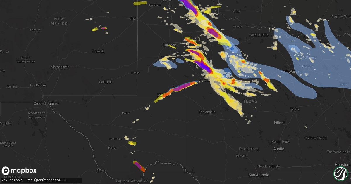
Hail Map on June 8, 2025
Get this storm
June 8 map
$229
one time, instant access
Download today. No call, no setup
Keep the $229
Bought the map and want the full workflow? Apply the entire $229 to a subscription within 7 days. None of it is wasted.
Every map, not just this one
This buys you this map. Subscription and you get every map we run, in the markets you choose from a few cities to whole states to nationwide. Plus real-time alerts the moment a storm fires.
Contact data
Name, contact info, occupancy, even credit band for addresses in the footprint. You go from where it hit to who to call.
Become the source they trust
Unlimited branding weather history reports on demand. You already have the documented answer ready for the property owner, and you are the one who showed up with it.
Property data and RoofTrace estimates
Pull up any address you have got, its value and the exact code rules for that jurisdiction, straight from One Click Code. Then RoofTrace estimates the squares, pitch, and roof value, priced the way you price.
States Impacted by Hail Map on June 8, 2025
Storm reports
Texas
| Date | Description |
|---|---|
| 06/08/20256:54 PM CDT | Report from mping: half dollar |
| 06/08/20256:50 PM CDT | 911 call center has recieved reports of numerous trees down across the county. Many county roads and main roads have trees down. Road crews are currently attempting to |
| 06/08/20256:46 PM CDT | Time of hail estimated. |
| 06/08/20256:46 PM CDT | Peak wind gust measured by the west texas mesonet. Additional gusts of 58 mph or greater occurred between 6:43 and 6:50 pm. |
| 06/08/20256:46 PM CDT | Size ranged from 0.5 to 1 inch. |
| 06/08/20256:45 PM CDT | Time of hail fall estimated. |
| 06/08/20256:40 PM CDT | Sheriffs office reported quarter size hail falling at their office. |
| 06/08/20256:40 PM CDT | Photo received from the public of hail slightly larger than quarters just outside of cooper. |
| 06/08/20256:40 PM CDT | Report from mping: golf ball |
| 06/08/20256:38 PM CDT | Picture of hail from social media. Time of hail fall estimated. |
| 06/08/20256:37 PM CDT | Report from mping: half dollar |
| 06/08/20256:36 PM CDT | Icechip report measured at 24mm and rounded for report. |
| 06/08/20256:35 PM CDT | Wind and dirt blew very intensely. The winds caused tree damage and blew in the north side of a large shed some. Time damage occurred is estimated. |
| 06/08/20256:35 PM CDT | Picture of 2.069 inch diameter hail precisely measured. Time of hail is estimated. |
| 06/08/20256:35 PM CDT | A local report indicates 2.50 inch wind near 4 S Paducah |
| 06/08/20256:35 PM CDT | Time of hail estimated. |
| 06/08/20256:35 PM CDT | Report from mping: quarter |
| 06/08/20256:33 PM CDT | Peak wind gust measured by the west texas mesonet. Gusts of 60 mph or greater occurred between 6:32 and 6:37 pm. |
| 06/08/20256:32 PM CDT | Report from mping of quarter sized hail. |
| 06/08/20256:32 PM CDT | Report from mping: quarter |
| 06/08/20256:31 PM CDT | Icechip report measured at 35mm and rounded for report. |
| 06/08/20256:30 PM CDT | Pictures of hail as large as 2.5 inches in diameter. Time of hail fall is estimated. |
| 06/08/20256:25 PM CDT | Picture of large tree limbs down in paducah. Time of damage estimated. |
| 06/08/20256:25 PM CDT | Public reports ping pong ball sized hail near bland lake. |
| 06/08/20256:24 PM CDT | Icechip report measured at 30mm and rounded for report. |
| 06/08/20256:24 PM CDT | Report from mping: half dollar |
| 06/08/20256:22 PM CDT | Reports of measured one inch hail stones at the intersection of hwy 205 and cr 182. |
| 06/08/20256:15 PM CDT | A local report indicates 1.50 inch wind near 7 W Channing |
| 06/08/20256:15 PM CDT | Icechip report measured at 33mm and rounded for report. |
| 06/08/20256:14 PM CDT | Hail as large as golf balls falling currently. |
| 06/08/20256:10 PM CDT | Icechip report measured at 33mm and rounded for report. |
| 06/08/20256:04 PM CDT | Report from mping: golf ball |
| 06/08/20256:00 PM CDT | A local report indicates 1.00 inch wind near Panhandle |
| 06/08/20256:00 PM CDT | Power pole bent over the roadway. Lines still attached... Hanging at about 6 to 7 feet above the roadway. Time is when the report came in. Damage may have occurred earl |
| 06/08/20256:00 PM CDT | A local report indicates 58 MPH wind near 10 WNW Pyote |
| 06/08/20256:00 PM CDT | Steeple of church blown off. Time of damage estimated. |
| 06/08/20255:58 PM CDT | Social media report of golf ball size hail near hwy 7. |
| 06/08/20255:53 PM CDT | Images from social media of hail measuring three quarter of an inch to one inch south of lipan. |
| 06/08/20255:51 PM CDT | Measured by the west texas mesonet. Another gust to 60 mph was measured at 5:53 pm. |
| 06/08/20255:50 PM CDT | Quarter size hail reported in morgan mill by fd. |
| 06/08/20255:46 PM CDT | Report from mping: quarter |
| 06/08/20255:44 PM CDT | Quarter size hail in lake dallas via amateur radio. |
| 06/08/20255:26 PM CDT | Report from mping: quarter |
| 06/08/20255:25 PM CDT | Report from icechip research team. |
| 06/08/20255:25 PM CDT | A local report indicates 1.25 inch wind near 5 WSW Borger |
| 06/08/20255:25 PM CDT | Report from mping. Quarter size hail. |
| 06/08/20255:24 PM CDT | Report from mping. Quarter size hail. |
| 06/08/20255:21 PM CDT | West texas mesonet. Also measured a gust to 59 mph at 5:22 pm. |
| 06/08/20255:20 PM CDT | Damage to the first baptist church of timpson reported via broadcast media source. |
| 06/08/20255:19 PM CDT | Report from mping: hen egg |
| 06/08/20255:13 PM CDT | Report from mping: golf ball |
| 06/08/20255:10 PM CDT | 2.2 inch hail measured by icechip. Time of hail is estimated. |
| 06/08/20255:09 PM CDT | Nssl team measured a 90 mph wind gust with their mobile mesonet. The winds overturned a center pivot near this location. (lu |
| 06/08/20255:09 PM CDT | Nssl team measured a 90 mph wind gust with their mobile mesonet. The winds overturned a center pivot near this location. |
| 06/08/20255:07 PM CDT | Report from mping: hen egg+ |
| 06/08/20254:54 PM CDT | Report of half dollar size hail near the intersection of county road 106 and county road 103. |
| 06/08/20254:49 PM CDT | A local report indicates 1.75 inch wind near Stinnett |
| 06/08/20254:40 PM CDT | Reports of a lost barn and roof damage. Time estimated from radar. |
| 06/08/20254:40 PM CDT | Mesonet gusted to 65 mph at 1640cdt and continued to gust above 58 mph until 1646cdt. Peak gust of 83 mph occurred at 1642cdt. |
| 06/08/20254:39 PM CDT | Emergency manager confirmed tornado was on the ground. |
| 06/08/20254:30 PM CDT | Photo submitted via social media. |
| 06/08/20254:30 PM CDT | Report on social media indicates structural damage at a convenience store/gas station with large window blown in. |
| 06/08/20254:27 PM CDT | Corrects previous tornado report from 2 n borger. Tornado damage preliminarily supports ef0. The tornado was likely on the ground for one minute. Photos were obtained f |
| 06/08/20254:23 PM CDT | A local report indicates 1.50 inch wind near Stinnett |
| 06/08/20254:20 PM CDT | Storm chaser reported a funnel reaching the ground multiple times before quickly going back up. |
| 06/08/20254:16 PM CDT | Report from mping: grapefruit+ |
| 06/08/20254:16 PM CDT | A local report indicates 1.50 inch wind near Stinnett |
| 06/08/20254:11 PM CDT | Report from mping: baseball++ |
| 06/08/20254:05 PM CDT | Report from mping: quarter |
| 06/08/20253:52 PM CDT | A local report indicates 1.75 inch wind near 10 ESE Texline |
| 06/08/20253:51 PM CDT | A local report indicates 1.50 inch wind near 7 S Claude |
| 06/08/20253:51 PM CDT | 911 call center received reports of several trees and powerlines down in the vicinity of longview heights. |
| 06/08/20253:42 PM CDT | A local report indicates 1.75 inch wind near 9 S Claude |
| 06/08/20253:40 PM CDT | Report from mping: quarter |
| 06/08/20253:38 PM CDT | Report from mping: quarter |
| 06/08/20253:17 PM CDT | Picture submitted via slack of a tornado on the ground. |
| 06/08/20253:15 PM CDT | A local report indicates 1.25 inch wind near 10 W Claude |
| 06/08/20252:46 PM CDT | Report from mping: quarter |
| 06/08/20252:41 PM CDT | Report from mping: half dollar |
| 06/08/202511:58 AM CDT | Social media report of 68mph sustained winds recorded via personal weather station. |
| 06/08/202511:11 AM CDT | A local report indicates 60 MPH wind near Weatherford |
| 06/08/20258:31 AM CDT | A local report indicates 1.50 inch wind near 3 NW Sylvester |
| 06/08/20258:16 AM CDT | Report from mping: quarter |
| 06/08/20258:10 AM CDT | Report from mping: baseball |
| 06/08/20258:07 AM CDT | Mesonet station 113 5w rotan rotan/fisher county. |
| 06/08/202512:39 AM CDT | Asos station kmaf midland. |
| 06/08/202512:35 AM CDT | Kinj awos. |
| 06/08/202512:30 AM CDT | Report of multiple trees down in overton... Tx. |
| 06/08/202512:10 AM CDT | A local report indicates 1.00 inch wind near 3 ENE Tuscola |
| 06/07/202511:58 PM CDT | Social media images of tree around 8 to 12 inches in diameter... Snapped around 6 feet off the ground. Time estimated. |
| 06/07/202511:49 PM CDT | Report fro |
| 06/07/202511:49 PM CDT | Report from mping: golf ball |
| 06/07/202511:47 PM CDT | Report from mping: half dolla |
| 06/07/202511:47 PM CDT | A local report indicates 2.50 inch wind near 3 SE Dyess Afb |
| 06/07/202511:47 PM CDT | Report from mping: half dollar |
| 06/07/202511:45 PM CDT | Em report of a tree on a house 3.5 sw of pittsburg. |
| 06/07/202511:45 PM CDT | Report from mping: golf ball |
| 06/07/202511:44 PM CDT | A local report indicates 61 MPH wind near 2 WNW Clyde |
| 06/07/202511:42 PM CDT | *** 1 fatal *** corrects previous tstm wnd dmg report from 4 sw pittsburg. Corrected location and time. Tree fell on a manufactured home. |
| 06/07/202511:40 PM CDT | Mesonet station 26 gail 2se. |
| 06/07/202511:40 PM CDT | A local report indicates 71 MPH wind near 2 SW White Settlement |
| 06/07/202511:40 PM CDT | A local report indicates 60 MPH wind near 2 W Joshua |
| 06/07/202511:34 PM CDT | Report from mping: ping pong ball |
| 06/07/202511:25 PM CDT | Tree down along temple hall highway. |
| 06/07/202511:19 PM CDT | 78 mph wind gust at the west texas mesonet location on the acu campus. |
| 06/07/202511:17 PM CDT | Mesonet station 84 2wnw tarzan/martin county. |
| 06/07/202511:17 PM CDT | Multiple branches down. Fence knocked down. |
| 06/07/202511:12 PM CDT | Report of trees down in titus county. |
| 06/07/202511:11 PM CDT | Corrects previous tstm wnd gst report from weatherford. |
| 06/07/202511:02 PM CDT | Spotter network report. |
| 06/07/202511:00 PM CDT | Emergency manager reported a few trees down near the fm 906 and fm 197. Time estimated by radar. |
| 06/07/202510:57 PM CDT | Dfw airport asos gusted to 68 mph. |
| 06/07/202510:56 PM CDT | Mesonet station 18 lamesa 2se. |
| 06/07/202510:56 PM CDT | Report from mping: quarter |
| 06/07/202510:55 PM CDT | Awos station kluv lamesa. |
| 06/07/202510:53 PM CDT | Mineral wells asos gusted to 69 mph. |
| 06/07/202510:50 PM CDT | 60 mph wind gust measured at lakeside park. |
| 06/07/202510:47 PM CDT | Image of tree fallen onto home in cumby... Causing damage to roof. |
| 06/07/202510:44 PM CDT | Images of roof torn off metal building and powerlines downed on hwy 180 west of mineral wells. |
| 06/07/202510:43 PM CDT | Multiple 60 mph wind reports in and near richardson. |
| 06/07/202510:39 PM CDT | Trained spotter via ham radio reported in golfball size hail over i-20 in baird... Tx. |
| 06/07/202510:35 PM CDT | Report from mping: half dollar |
| 06/07/202510:34 PM CDT | Social media image of windows blown in at rw miller power plant. Time estimated. |
| 06/07/202510:34 PM CDT | Report from mping: half dollar |
| 06/07/202510:33 PM CDT | A local report indicates 67 MPH wind near 5 SSW Graham |
| 06/07/202510:29 PM CDT | 60 mph winds reported in honey grove. |
| 06/07/202510:27 PM CDT | Images of small metal outbuilding destroyed in coalville area. |
| 06/07/202510:22 PM CDT | Social media images of porch roof torn off of home... Small metal outbuilding destroyed in gordon... Texas. |
| 06/07/202510:19 PM CDT | Trees downed and roof damage to metal buildings along dairy farm road. |
| 06/07/202510:16 PM CDT | Mesonet station 96 welch dawson county. |
| 06/07/202510:15 PM CDT | Emergency management reports thunderstorm wind damage and debris along us 82 near hwy 78 and hwy 121. |
| 06/07/202510:15 PM CDT | Emergency management reports estimated 80 mph wind gusts and trees down in dodd city. |
| 06/07/202510:12 PM CDT | Trees down in strawn... Texas. |
| 06/07/202510:12 PM CDT | Reports of grain silos collapsed in windom. |
| 06/07/202510:10 PM CDT | Report of widespread tree damage and some structure damage in dodd city. Time estimated. |
| 06/07/202510:07 PM CDT | Trained spotter reports a measured wind gust of 65 mph at i-35e and 407 northwest of lewisville. |
| 06/07/202510:07 PM CDT | A local report indicates 65 MPH wind near 5 SSW Graham |
| 06/07/202510:05 PM CDT | Trained spotter reported 1 inch hail over noodle... Tx via ham radio. |
| 06/07/202510:00 PM CDT | Widespread wind damage reported near ravenna. Time estimated. |
| 06/07/20259:57 PM CDT | A local report indicates 60 MPH wind near 5 SSW Graham |
| 06/07/20259:50 PM CDT | Ham radio estimates 50-60 mph wind gusts in the city of alvord. |
| 06/07/20259:48 PM CDT | Emergency management reports a large tree blown over on suv. Driver trapped but no apparent injuries. |
| 06/07/20259:44 PM CDT | Ham radio reports a measured wind gust of 63 mph at twu guinn hall. |
| 06/07/20259:42 PM CDT | Trained spotter reports a measured wind gust of 82 mph near the fm922 and fm2848 intersection north of sanger. |
| 06/07/20259:40 PM CDT | Weather station north of collinsville reported 62 mph wind gust. |
| 06/07/20259:35 PM CDT | Report from mping: half dollar |
| 06/07/20259:33 PM CDT | Trained spotter estimates 55-60 mph wind gusts 2 miles wnw of tioga. |
| 06/07/20259:29 PM CDT | Report from mping: half dollar |
| 06/07/20259:27 PM CDT | Emergency management reports a measured wind gust of 69 mph 4 miles west of callisburg. |
| 06/07/20259:25 PM CDT | A local report indicates 66 MPH wind near 4 ENE Albany |
| 06/07/20259:24 PM CDT | A local report indicates 61 MPH wind near 2 SE Truscott |
| 06/07/20259:19 PM CDT | Emergency management estimates 60 mph wind gusts in the city of callisburg. Power is out in the area. |
| 06/07/20259:17 PM CDT | A local report indicates 68 MPH wind near 2 SE Truscott |
| 06/07/20259:15 PM CDT | Nws san antonio/austin relayed a report from a spotter stating they saw golfball size hail in woodson... Tx around 9:15 pm. |
| 06/07/20259:05 PM CDT | Woodson fire department reported 70 to 75 mph wind gusts. |
| 06/07/20259:05 PM CDT | Woodson fire dept reported 1 inch hail 1 mile north of woodson. |
| 06/07/20258:50 PM CDT | Law enforcement reported multiple powerlines down along fm57 north. |
| 06/07/20258:45 PM CDT | Law enforcement reported a hog farm e of roby... Tx had damage to their property and multiple powerlines down along the road. |
| 06/07/20258:45 PM CDT | A local report indicates 86 MPH wind near 3 N Avoca |
| 06/07/20258:35 PM CDT | Mesonet station 105 5nw colorado city. |
| 06/07/20258:34 PM CDT | Time estimated from radar. |
| 06/07/20258:29 PM CDT | Report from mping: quarter |
| 06/07/20258:26 PM CDT | Downed power poles and lines along road. |
| 06/07/20258:24 PM CDT | Time estimated by radar. |
| 06/07/20258:20 PM CDT | Corrects previous tstm wnd gst report from 2 nnw haskell. |
| 06/07/20258:20 PM CDT | A local report indicates 66 MPH wind near 2 NNW Haskell |
| 06/07/20258:17 PM CDT | Report from mping: quarter |
| 06/07/20258:10 PM CDT | Semi rolled over on highway 277. |
| 06/07/20258:10 PM CDT | A local report indicates 100 MPH wind near 4 NNW Goree |
| 06/07/20258:05 PM CDT | A local report indicates 68 MPH wind near 4 NNW Goree |
| 06/07/20258:05 PM CDT | ( |
| 06/07/20258:05 PM CDT | A local report indicates 60 MPH wind near 3 NW Knox City |
| 06/07/20258:05 PM CDT | A local report indicates 75 MPH wind near Persimmon Gap |
| 06/07/20258:03 PM CDT | A local report indicates 2.50 inch wind near Coahoma |
| 06/07/20258:01 PM CDT | A local report indicates 73 MPH wind near 2 NNE Weinert |
| 06/07/20258:01 PM CDT | A local report indicates 58 MPH wind near Midway |
| 06/07/20258:00 PM CDT | A local report indicates 60 MPH wind near 3 NW Knox City |
| 06/07/20258:00 PM CDT | Emergency manager reports a roof was damaged at a school. Numerous trees were also down across the city. Time estimated via radar. |
| 06/07/20258:00 PM CDT | A local report indicates 68 MPH wind near 4 NNW Goree |
| 06/07/20257:58 PM CDT | A local report indicates 81 MPH wind near 4 W Rotan |
| 06/07/20257:58 PM CDT | Corrects previous tstm wnd gst report from 5 w rotan. |
| 06/07/20257:55 PM CDT | A local report indicates 60 MPH wind near 3 NW Knox City |
| 06/07/20257:53 PM CDT | Described as having fallen near mm179 on i-20. |
| 06/07/20257:52 PM CDT | Peak wind gust measured by the west texas mesonet with this round of storms. Additional gusts of 59 mph or greater occurred at 7:51 and 7:53 pm. |
| 06/07/20257:50 PM CDT | Multiple reports that most west facing windows are broken at hotel settles in big spring due to damaging wind-driven hail. |
| 06/07/20257:50 PM CDT | Time estimated from radar. |
| 06/07/20257:45 PM CDT | A local report indicates 66 MPH wind near 3 NW Knox City |
| 06/07/20257:42 PM CDT | Mesonet station 59 3nw knox city. |
| 06/07/20257:37 PM CDT | Sheriff department reported multiple trees down and power outages around the browndell area. Time estimated from radar. |
| 06/07/20257:30 PM CDT | Report from mping: half dollar |
| 06/07/20257:25 PM CDT | A local report indicates 81 MPH wind near 2 SE Truscott |
| 06/07/20257:21 PM CDT | A local report indicates 64 MPH wind near 5 SW Saint Lawrence |
| 06/07/20257:20 PM CDT | A local report indicates 81 MPH wind near 2 SE Truscott |
| 06/07/20257:20 PM CDT | A local report indicates 67 MPH wind near 3 NW Greenwood |
| 06/07/20257:18 PM CDT | Report from mping: hen egg |
| 06/07/20257:15 PM CDT | A power pole snapped on fm 267. |
| 06/07/20257:15 PM CDT | A local report indicates 80 MPH wind near 2 SE Truscott |
| 06/07/20257:12 PM CDT | Picture provided by em. Time estimated by radar. |
| 06/07/20257:11 PM CDT | Report of wind driven hail damaging windows of an rv/trailer. Time estimated by radar. |
| 06/07/20257:10 PM CDT | A local report indicates 74 MPH wind near 2 SE Truscott |
| 06/07/20257:05 PM CDT | A local report indicates 1.25 inch wind near 2 WNW Midland |
| 06/07/20257:05 PM CDT | A local report indicates 1.75 inch wind near 2 NW Midland |
Wisconsin
| Date | Description |
|---|---|
| 06/08/20255:17 PM CDT | Facebook post with pictures of nickel to quarter size hail. |
| 06/08/20255:14 PM CDT | Report from mping: quarter |
Oklahoma
| Date | Description |
|---|---|
| 06/08/20256:25 PM CDT | Mesonet station wato watonga. |
| 06/08/20256:20 PM CDT | Mesonet station wato watonga. |
| 06/08/20256:15 PM CDT | Awos station kclk clinton. |
| 06/08/20256:10 PM CDT | A local report indicates 1.00 inch wind near 4 NW Eagle City |
| 06/08/20256:05 PM CDT | Tree down across road at 630 and e20 road... Near alt us 69. Time was estimated from radar. |
| 06/08/20255:35 PM CDT | A local report indicates 1.75 inch wind near 2 NNE Canton Lake |
| 06/08/20255:32 PM CDT | A local report indicates 1.00 inch wind near 5 NE Hucmac |
| 06/08/20255:20 PM CDT | A local report indicates 1.75 inch wind near Dempsey |
| 06/08/20254:09 PM CDT | A local report indicates 70 MPH wind near 2 N Blackwell |
| 06/08/20253:57 PM CDT | A local report indicates 1.00 inch wind near 5 S Bryans Corner |
| 06/08/20253:15 PM CDT | Lots of broken tree limbs in town. Time estimated. |
| 06/08/20253:15 PM CDT | At least 12 power poles reported snapped in half between medford and pond creek. Time estimated. |
| 06/08/20253:10 PM CDT | Picture was submitted through social media. |
| 06/08/20252:58 PM CDT | A local report indicates 63 MPH wind near 3 N Nash |
| 06/08/20252:47 PM CDT | Tornado was confirmed on the ground by multiple storm chasers. |
| 06/08/20252:14 PM CDT | Image sent to the em. |
| 06/07/20259:50 PM CDT | A local report indicates 59 MPH wind near 1 WNW Lane |
| 06/07/20259:50 PM CDT | Several trees and power poles downed on south research road starting at hwy 3 to blackjack road. Time estimated. |
| 06/07/20259:45 PM CDT | A local report indicates 66 MPH wind near 1 WNW Lane |
| 06/07/20259:40 PM CDT | Tree damage reported in town. Time estimated. |
| 06/07/20259:30 PM CDT | Barn destroyed and trees downed in calera. Time estimated. |
| 06/07/20259:30 PM CDT | Roof damage reported in cartwright. |
| 06/07/20259:29 PM CDT | 60 to 70 mph winds estimated. |
| 06/07/20259:20 PM CDT | Trees downed near achille... Time estimated from radar and reports. Possible tornado. |
| 06/07/20259:05 PM CDT | Trees downed and large area near thackerville without power. Time estimated. |
| 06/07/20258:55 PM CDT | Roof damage to metal shop building. |
| 06/07/20258:45 PM CDT | Power line down near 17th ave and earl st. Radar estimated time. |
| 06/07/20258:37 PM CDT | A local report indicates 60 MPH wind near 3 NW Norman |
| 06/07/20258:37 PM CDT | Near intersection of bridge rd and cemetery rd. |
| 06/07/20258:30 PM CDT | A local report indicates 61 MPH wind near 3 NNE Lone Grove |
| 06/07/20258:30 PM CDT | Trees and power lines down. Radar estimated time. |
| 06/07/20258:20 PM CDT | Power lines downed and a few homes with minor roof damage south of lone grove. Time estimated. |
| 06/07/20257:15 PM CDT | A local report indicates 60 MPH wind near 5 SW Adair |
| 06/07/20257:15 PM CDT | Awos station kjwg watonga. |
| 06/07/20257:10 PM CDT | Several power poles reported downed. Time estimated. |
Michigan
| Date | Description |
|---|---|
| 06/08/20256:03 PM CDT | Time estimated from radar. |
North Carolina
| Date | Description |
|---|---|
| 06/08/20254:05 PM CDT | Peak wind gust measured at the frisco woods weatherflow station. |
| 06/08/20254:05 PM CDT | Peak wind gust |
| 06/08/20253:33 PM CDT | Peak gust at the ocracoke weatherflow station. |
| 06/08/20252:33 PM CDT | Power lines down across roadway along nc 101 near eastmans creek. Tree also down in vicinity. Report relayed via facebook... Time estimated by radar. |
| 06/08/20252:18 PM CDT | Numerous trees reported down on the south side of havelock. |
| 06/08/20252:14 PM CDT | Flag pole snapped at the base. Large tree branch on a home in the same location. |
| 06/08/20252:14 PM CDT | Large branches down along roberts road. |
| 06/08/20252:13 PM CDT | Large top half of healthy tree blown down along nine mile road... Near the intersection of gales creek road and nine mile. Time estimated by radar. |
| 06/08/20252:11 PM CDT | Multiple trees down across the town. |
| 06/08/20252:08 PM CDT | Farm cage destroyed. Tree on 9 foot road. Large branches down. Report relayed via wcti. |
| 06/08/20252:07 PM CDT | Estimated 50 to 60 mph wind gusts along highway 24 near bogue. |
| 06/08/20251:45 PM CDT | Tree down on vehicle near white rd. And alamosa dr. |
| 06/08/20251:30 PM CDT | Tree down on roadway at intersection of 3rd st and brunswick st in downtown wilmington |
| 06/08/20251:30 PM CDT | Tree down on 3rd and market in downtown wilmington |
| 06/08/202512:43 PM CDT | Tree down along ramsey ford rd. |
| 06/08/202512:40 PM CDT | Tree down along mill pond rd. |
| 06/08/202512:35 PM CDT | Tree down along midway drive... South of rough and ready road. |
| 06/08/202512:35 PM CDT | Tree down on strawberry blvd |
| 06/08/202512:35 PM CDT | Tree down along wright rd. |
New Mexico
| Date | Description |
|---|---|
| 06/08/20256:23 PM CDT | Trained spotter reports quarter size hail in his ranch near gladstone. |
| 06/07/20259:30 PM CDT | Hail size ranged from dime to ping pong ball size. |
| 06/07/20257:27 PM CDT | Awos station kcvs cannon air force base. |
Kansas
| Date | Description |
|---|---|
| 06/08/20256:20 PM CDT | A local report indicates 1.00 inch wind near Howard |
| 06/08/20256:19 PM CDT | Relayed from a viewer. |
| 06/08/20256:17 PM CDT | A local report indicates 1.25 inch wind near 2 WSW Howard |
| 06/08/20255:49 PM CDT | 50 to 60 mph winds were estimated. |
| 06/08/20255:45 PM CDT | Pictures of large tree branches and a tree snapped off of bagdad road south of galena. |
| 06/08/20255:34 PM CDT | Amateur radio spotter just outside of galena... Kansas reports high winds and 8 inch tree limbs down. Time estimated from radar. |
| 06/08/20255:22 PM CDT | Nickel to up to quarter sized hail covering the ground. |
| 06/08/20255:12 PM CDT | Cocorahs report of half dollar sized hail 3.6 north of columbus... Kansas. Time estimated from radar. |
| 06/08/20254:21 PM CDT | Report via social media of pea to quarter sized hail. Time estimated via radar. |
| 06/08/20254:11 PM CDT | Kake chaser reported lots of hail with mostly nickels but some quarter sized stones. |
| 06/08/20254:11 PM CDT | Delayed report of quarter size hail north of girard. |
| 06/08/20254:09 PM CDT | Marble to quarter sized hail reported by the independence daily reporter. |
| 06/08/20254:04 PM CDT | Trained spotter estimates at least 60 mph. |
| 06/08/20254:01 PM CDT | Three power poles down. Time is radar estimated. |
| 06/08/20253:37 PM CDT | A local report indicates 1.00 inch wind near 6 NE Kanopolis |
| 06/08/20253:35 PM CDT | Report and photo of approximately quarter sized hail via social media. |
| 06/08/20253:35 PM CDT | Fort scott awos measured a 60 mph wind gust. |
| 06/08/20253:35 PM CDT | A local report indicates 1.00 inch wind near Dodge City |
| 06/08/20253:26 PM CDT | Report relayed from em of 2 inch hail near fort scott... Kansas. Time estimated from radar. |
| 06/08/20253:10 PM CDT | A local report indicates 1.00 inch wind near 2 ESE Devon |
| 06/08/20252:56 PM CDT | Report relayed via emergency management near bronson... Kansas. |
| 06/08/20252:20 PM CDT | Social media report. |
| 06/08/202512:05 PM CDT | Video via social media. |
Illinois
| Date | Description |
|---|---|
| 06/08/20254:03 PM CDT | A large tree was damaged. |
| 06/08/20253:23 PM CDT | Large tree branches downed at multiple residences near lacey road and ogden avenue in downers grove. |
| 06/08/20252:58 PM CDT | Corrects location of previous tstm wnd gst report from batavia. Coop observer measured 83 mph gust on personal weather station in batavia. Large tree branches were down |
| 06/08/20252:58 PM CDT | Photo shared on social media showing hailstones roughly twice the size of a quarter along main street east of randall road in batavia. |
| 06/08/20252:58 PM CDT | Power pole snapped along wilson street near river street in batavia. |
| 06/08/20252:58 PM CDT | Corrects location of previous hail report from batavia. Coop observer in batavia reported wind-driven hail with the largest hailstones approximately golf ball sized. |
| 06/08/20252:58 PM CDT | Updates previous tstm wnd gst report from batavia. Coop observer measured 83 mph gust on personal weather station in batavia. Large tree branches were downed. |
| 06/08/20252:58 PM CDT | Large tree snapped at harrison street and carlisle road in batavia. |
| 06/08/20252:58 PM CDT | Coop observer estimated 70 mph wind gusts in batavia. Large tree branches were downed. |
| 06/08/20252:58 PM CDT | Coop observer in batavia reported wind-driven hail with the largest hailstones approximately golf ball sized. |
| 06/08/20252:58 PM CDT | Multiple trees downed in batavia. |
| 06/08/20252:57 PM CDT | Meteorology professor reported hail up to 2.5 inches in diameter in batavia. Average hailstone diameter was approximately 2 inches. |
| 06/08/20252:57 PM CDT | Mping report. |
| 06/08/20252:57 PM CDT | Quarter size hail reported at first street and lincoln street in batavia. |
| 06/08/20252:57 PM CDT | Photo shared on social media of approximately 2 to 2.5 inch diameter hail in batavia. A video shared under the same post showed wind-driven hail destroying a window scr |
| 06/08/20252:56 PM CDT | Mping report. |
| 06/08/20252:56 PM CDT | Trained spotter shared photos of multiple elongated hailstones measuring greater than 2 inches in diameter in batavia. |
| 06/08/20252:56 PM CDT | Quarter size hail reported at randall road and main street in batavia. |
| 06/08/20252:56 PM CDT | Golf ball size hail reported at main street and nelson lake road in batavia. |
| 06/08/20252:56 PM CDT | Quarter size hail reported near randall road and mckee street in batavia. |
| 06/08/20252:56 PM CDT | Mping report. |
| 06/08/20252:54 PM CDT | 2 inch diameter hail reported near fabyan parkway and branson drive in batavia. |
| 06/08/20252:54 PM CDT | Photo shared of a hailstone just under 1.5 inches in diameter. |
| 06/08/20252:48 PM CDT | Corrects location of previous hail report from 1 ese elburn. Hail ranged from quarter to golf ball size on the southwest side of geneva. |
| 06/08/20252:45 PM CDT | Hail ranged from quarter to golf ball size on the southwest side of geneva. |
| 06/08/20252:45 PM CDT | Photos shared of trees and large tree limbs downed along main street west of bunker road. Time estimated from radar. |
| 06/08/20252:43 PM CDT | Multiple public reports of quarter size hail in elburn. Time estimated from radar. |
| 06/08/20252:15 PM CDT | Photo shared of 5 utility poles blown down near peace road and route 38. Time estimated. |
| 06/08/20252:15 PM CDT | Power poles downed onto webster road north of i-88 southeast of dekalb. Time estimated from radar. |
| 06/08/202512:07 AM CDT | Trees down... Powerlines down... Box trailer flipped along highway 149. |
Missouri
| Date | Description |
|---|---|
| 06/08/20255:56 PM CDT | Emergency manager relayed report of quarter hail just north of rich hill along i49. |
| 06/08/20255:38 PM CDT | Report via social media of a tree down over the road. Time estimated via radar. |
| 06/08/20255:25 PM CDT | Delayed report through contact. Numerous large trees blown over. |
| 06/08/20253:58 PM CDT | Social media report. |
| 06/08/20253:44 PM CDT | Emergency manager relayed photo of measured hail between 2 and 2.5 inches. |
| 06/08/20253:32 PM CDT | Emergency manager relayed photo of quarter to half dollar sized hail in the unincorporated town of germantown. |
| 06/08/20253:32 PM CDT | A local report indicates 1.00 inch wind near 3 NW Montrose |
| 06/08/20253:30 PM CDT | Social media report. |
| 06/08/20253:29 PM CDT | Emergency manager relayed pictures of large hail nw of montrose. Time estimated from radar. |
| 06/08/20253:28 PM CDT | Social media report. |
| 06/08/20253:25 PM CDT | Social media picture east of ballard. |
| 06/08/202512:50 AM CDT | Poplar bluff asos. |
| 06/08/202512:50 AM CDT | P |
| 06/07/20258:09 PM CDT | Photo from social media of several stones between half dollar and golf ball size hail. Large volume of hail reported within the storm... With missouri state highway pat |
| 06/07/20258:06 PM CDT | Hail reported to cover the ground. |
| 06/07/20258:02 PM CDT | Report from mping - quarter 1.00 in. |
| 06/07/20257:32 PM CDT | A local report indicates 1.00 inch wind near Steelville |
| 06/07/20257:15 PM CDT | Picture of hail just larger than quarter size in osceola. |
Indiana
| Date | Description |
|---|---|
| 06/07/20257:10 PM CDT | 8-10 inch diameter limbs broken. |
| 06/07/20257:05 PM CDT | Part of shed roof blown off. |
| 06/07/20257:05 PM CDT | Large treen downed. |
| 06/07/20257:05 PM CDT | Corrects previous tstm wnd dmg report from 1 se dunlap. Part of shed roof blown off. |
Colorado
| Date | Description |
|---|---|
| 06/07/20257:08 PM CDT | A local report indicates 1.00 inch wind near 4 W Elbert |
South Carolina
| Date | Description |
|---|---|
| 06/08/20251:54 PM CDT | Tree reported down on green pond hwy and clover hill rd. Time estimated from radar. |
| 06/08/202512:50 PM CDT | Large branches down on power lines along paris lane |
| 06/08/202512:50 PM CDT | Tree down on pennyroyal rd near mineral place. |
| 06/08/202512:42 PM CDT | Tree reported down along highway 17 at sam thompson drive. Time estimated from radar. |
| 06/08/202512:39 PM CDT | Tree down along highway 17 near steed creek. Time estimated from radar. |
| 06/08/202512:30 PM CDT | Tree down on cumbee rd. |
| 06/08/202512:29 PM CDT | Tree reported down along highway 17 near combahee road. Time estimated from radar. |
| 06/08/202512:27 PM CDT | Powerlines reported down along hoover ave at berkeley street. Time estimated from radar. |
| 06/08/202512:27 PM CDT | Tree reported down on bethera road near ackerman road. Time estimated from radar. |
| 06/08/202512:20 PM CDT | Tree down blocking sc-19 near liner road in nichols. Time estimated based on radar. |
| 06/08/202512:15 PM CDT | Tree down on road in loris. |
| 06/08/202512:12 PM CDT | Tree reported down on power line along the 1900 block of summers drive. Time estimated from radar. |
| 06/08/202512:09 PM CDT | Tree reported down on trotters lane. Time estimated from radar. |
| 06/08/202512:09 PM CDT | Trees reported down on power lines in the 100 block of w main street. Time estiamted from radar. |
| 06/08/202512:00 PM CDT | Tree reported down on main street. Time estimated from radar. |
| 06/08/202512:00 PM CDT | Trees reported down on powerlines along gum ave. Time estimated from radar. |
| 06/08/202511:55 AM CDT | Tree down on nesmith rd. |
| 06/08/202511:55 AM CDT | Tree down in roadway. |
| 06/08/202511:54 AM CDT | Powerlines reported down along ace basin parkway at ashepoo drive. Time estimated from radar. |
| 06/08/202511:54 AM CDT | Tree reported down on green pond hwy and clover hill rd. Time estimated from radar. Corrected for updated time. |
| 06/08/202511:51 AM CDT | Trees reported down on powerlines along state road at sheep island road. Time estimated from radar. |
| 06/08/202511:51 AM CDT | Tree reported down along highway 17 near combahee road. Time estimated from radar. |
| 06/08/202511:48 AM CDT | Tree reported down in the 8600 block of green pond highway... Likely from thunderstorm outflow. Time estimated from radar. |
| 06/08/202511:45 AM CDT | Tree reported down on a powerline in the 100 block of pendarvis circle. Time estimated from radar. |
| 06/08/202511:45 AM CDT | Tree reported down in the 200 block of gruber street. Time estimated from radar. |
| 06/08/202511:37 AM CDT | Tree reported down and blocking both lanes of state road at highway 311. Time estimated from radar. |
| 06/08/202511:25 AM CDT | Tree reported down onto a vehicle on highway 15n at duncan chapel road... No injuries. Time estimated from radar. |
| 06/08/202511:22 AM CDT | Tree reported down in the 1700 block of h |
| 06/08/202511:22 AM CDT | Tree reported down in the 1700 block of highway 15. Time estimated from radar. |
| 06/08/202511:22 AM CDT | Powerlines reported down along garris ave at till lane. Time estimated from radar. |
| 06/08/202511:19 AM CDT | Tree reported down along charleston highway at shannon loop. Time estimated from radar. |
| 06/08/202511:17 AM CDT | The sc dot webcam on i-95 near mile marker 93 shows trees down on the interstate blocking the road. Time estimated from radar. |
| 06/08/202511:16 AM CDT | Tree reported down in the 15000 block of sniders highway... Likely due to thunderstorm outflow. Time estimated from radar. |
| 06/08/202511:13 AM CDT | Hail estimated at nickel to quarter size briefly fell near this location. Time estimated based on radar. |
| 06/08/202511:13 AM CDT | Clarendon county em relayed a picture of approximately quarter sized hail in the wyboo neighborhood. Time estimated by radar. |
| 06/08/202511:07 AM CDT | Multiple trees reported down along highway 321 just outside of estill. Time estimated from radar. |
| 06/08/202510:20 AM CDT | Spotter reports a small tree down across sc 261 near dalzell... Sc. |
| 06/08/202510:06 AM CDT | Sc dot reports trees down on us 601 near the intersection with garners ferry rd. Time estimated from radar. |
| 06/08/20259:55 AM CDT | Key net controller shared a picture of a large tree blocking the exit to a cul-de-sac on the 4200 block of devine street. Time estimated by radar. |
| 06/08/20259:38 AM CDT | Broadcast media relayed a picture of a tree down on the 900 block of tara trail causing minor damage to the property. Time estimated by radar. |
| 06/08/20258:37 AM CDT | Edgefield county dispatch reports trees down on gilgal rd. Time estimated from radar. |
Virginia
| Date | Description |
|---|---|
| 06/08/20256:56 PM CDT | Numerous large trees down. |
| 06/08/20256:35 PM CDT | Corrects time of previous tstm wnd dmg report from 3 ne denaro. Tree down across little patrick road. Time estimated from radar. |
| 06/08/20256:35 PM CDT | Corrects time of previous tstm wnd dmg report from 3 n denaro. Tree down in the roadway. Radar estimated time. |
| 06/08/20256:29 PM CDT | Large tree fell onto powerlines at the 1800 block of north mountain rd |
| 06/08/20256:25 PM CDT | Tree down across little patrick road. Time estimated from radar. |
| 06/08/20256:23 PM CDT | Tree down in the roadway. Radar estimated time. |
| 06/08/20255:32 PM CDT | Corrects previous tstm wnd dmg report from big island. Several trees down. |
| 06/08/20255:15 PM CDT | Trees down blocking several roads. County dispatch reporting trees down and roads blocked in several locations... From 6:00 pm to 6:30pm. |
| 06/08/20255:14 PM CDT | One tree down on evans mill road near the mount nebo church. |
| 06/08/20255:00 PM CDT | Called the 911 center... And the dispatcher mentioned a lot of trees were down across the county. |
| 06/08/20254:55 PM CDT | A local report indicates 1.00 inch wind near 1 N Cowie Corner |
| 06/08/20254:45 PM CDT | Corrects previous tstm wnd dmg report from 2 se briery creek lake. Tree downed on worsham road near meherrin rd. Time is radar-estimated. |
| 06/08/20254:45 PM CDT | Tree downed on worsham road. Time is radar-estimated. |
| 06/08/20254:43 PM CDT | Tree downed by thunderstorm winds on forest chapel road. |
| 06/08/20254:25 PM CDT | Scattered wind damage... Large limbs and trees down... Across the northern part of the county from 5:25-5:45pm. |
| 06/08/20254:24 PM CDT | Steeple blew off providence baptist church |
| 06/08/20254:23 PM CDT | Large limbs down. Measured wind gust 31 mph. |
| 06/08/20253:55 PM CDT | Tree down... Blocking entire road. |
| 06/08/20253:36 PM CDT | Tree knocked down at whistlers cove dr and little horn ridge. Time estimated from radar. |
| 06/08/20253:36 PM CDT | Tree knocked down along full rack dr. Time estimated from radar. |
| 06/08/20253:00 PM CDT | Powerline reported downed at jamestown road at sandy bay road. Time radar estimated. |
| 06/08/20251:50 PM CDT | Eyewitness report of a tornado that briefly touched down in a field for less than a minute north of baynesville rd outside of montross. |
| 06/08/20251:38 PM CDT | Tree knocked down near the intersection of harts landing rd and horners mill rd . Time estimated from radar. |
| 06/08/20258:01 AM CDT | Tree knocked down... Blocking 75 percent of the road at benefit road and s battlefield blvd. Time estimated from radar. |
| 06/07/202510:39 PM CDT | Tree and powerline down. |
| 06/07/20257:50 PM CDT | Multiple trees snapped along with power lines down near the intersection of oak grove lane and nelsons bridge rd. Call came in at 9:17 according to county officials... |
| 06/07/20257:08 PM CDT | Tree blocking roadway. Radar estimated time. |
Alabama
| Date | Description |
|---|---|
| 06/08/20253:15 PM CDT | Corrects previous hail report from babbie. Public report of quarter size hail. |
| 06/08/20253:15 PM CDT | Public report of quarter size hail. |
Louisiana
| Date | Description |
|---|---|
| 06/08/20254:47 PM CDT | Public reported quarter sized hail. |
| 06/08/20253:15 PM CDT | Sheriffs office reported trees down om carver road. |
Cities Impacted by Hail Map on June 8, 2025
- Snyder, TX
- Jayton, TX
- Girard, TX
- Rotan, TX
- Crosbyton, TX
- Hamlin, TX
- Sylvester, TX
- Roby, TX
- McCaulley, TX
- Troy, SC
- Bradley, SC
- Ninety Six, SC
- Dickens, TX
- Merkel, TX
- Anson, TX
- Summerton, SC
- Pinewood, SC
- Elloree, SC
- Bowman, SC
- Luray, SC
- Lynchburg, SC
- Manning, SC
- Saint George, SC
- Silverton, TX
- Holly Hill, SC
- Vance, SC
- Perryton, TX
- Reevesville, SC
- Lockney, TX
- Dorchester, SC
- Eutawville, SC
- Kingstree, SC
- Salters, SC
- Greeleyville, SC
- Lane, SC
- Sweet Water, AL
- Quitaque, TX
- Cross, SC
- Matador, TX
- Scranton, SC
- Turkey, TX
- Flomot, TX
- Ridgeville, SC
- Gresham, SC
- Marion, SC
- Pamplico, SC
- Dixons Mills, AL
- Chadbourn, NC
- Magnolia, AL
- Linden, AL
- Fair Bluff, NC
- Clarkton, NC
- Elizabethtown, NC
- Mullins, SC
- Nichols, SC
- Cerro Gordo, NC
- Pine Hill, AL
- Thomasville, AL
- Arlington, AL
- Whiteville, NC
- Kelly, NC
- Council, NC
- Clarendon, TX
- Georgetown, SC
- Ivanhoe, NC
- Loris, SC
- Green Sea, SC
- Fort Stewart, GA
- Tabor City, NC
- Conway, SC
- Atkinson, NC
- Currie, NC
- Coy, AL
- Longs, SC
- Nakina, NC
- Bolton, NC
- Paducah, TX
- Lake Waccamaw, NC
- Camden, AL
- Rocky Point, NC
- Burgaw, NC
- Ash, NC
- Beatrice, AL
- Riegelwood, NC
- Delco, NC
- Vredenburgh, AL
- Longwood, NC
- Childress, TX
- Castle Hayne, NC
- Kenton, OK
- Elkhart, KS
- Goodwell, OK
- Supply, NC
- Waynesville, GA
- Waverly, GA
- Jacksonville, NC
- Hilton Head Island, SC
- Wilmington, NC
- Pine Apple, AL
- Crowell, TX
- Peterman, AL
- Evergreen, AL
- New Zion, SC
- Pinopolis, SC
- Camp Lejeune, NC
- Liberal, KS
- Pineville, SC
- Hugoton, KS
- Hubert, NC
- Boise City, OK
- McKenzie, AL
- Stella, NC
- Swansboro, NC
- Newport, NC
- Garnett, KS
- Wrightsville Beach, NC
- Hooker, OK
- Centerville, KS
- Blue Mound, KS
- Dozier, AL
- Greenville, AL
- Red Level, AL
- Waynoka, OK
- Mooreland, OK
- Georgiana, AL
- Guymon, OK
- Tyrone, OK
- Alva, OK
- Felt, OK
- Wellington, TX
- Memphis, TX
- Harrisburg, MO
- Mound City, KS
- Mapleton, KS
- Dodson, TX
- Hollis, OK
- Maple Park, IL
- Elburn, IL
- Jet, OK
- Cimarron, KS
- Dekalb, IL
- Columbia, MO
- Cherokee, OK
- Geneva, IL
- Batavia, IL
- North Aurora, IL
- Mooseheart, IL
- Wilson, KS
- Uniontown, KS
- Redfield, KS
- Andalusia, AL
- Fulton, KS
- Dorrance, KS
- Spearville, KS
- Monterey, LA
- Moreauville, LA
- Lettsworth, LA
- Turpin, OK
- Sugar Grove, IL
- Moran, KS
- Wakita, OK
- Nash, OK
- Lake City, SC
- Sumter, SC
- Prescott, KS
- Fort Scott, KS
- Warrenville, IL
- Aurora, IL
- West Chicago, IL
- Naperville, IL
- Winfield, IL
- Claude, TX
- Wheaton, IL
- Medford, OK
- Winfield, KS
- Ellsworth, KS
- Longton, KS
- Dexter, KS
- Butler, MO
- Angola, LA
- Woodville, MS
- Cedar Vale, KS
- Bronson, KS
- Fredonia, KS
- Saint Francisville, LA
- Carmen, OK
- Dodge City, KS
- Elk City, KS
- Mount Hermon, LA
- Franklinton, LA
- Neodesha, KS
- Divide, CO
- Woodland Park, CO
- Dalhart, TX
- Pond Creek, OK
- Woodridge, IL
- Downers Grove, IL
- Lisle, IL
- Westmont, IL
- Glen Ellyn, IL
- Helena, OK
- Montrose, MO
- Saint Charles, IL
- Sedan, KS
- Chipley, FL
- Diana, TX
- Longview, TX
- Opp, AL
- Wasco, IL
- Urich, MO
- Green Mountain Falls, CO
- Cascade, CO
- Pollock, LA
- Ensign, KS
- Clinton, MO
- Stark, KS
- Elba, AL
- Hallsville, TX
- Tallula, IL
- Ashland, IL
- Pleasant Plains, IL
- Gilmer, TX
- Fort Davis, TX
- Mansura, LA
- Hessmer, LA
- Chanute, KS
- Texline, TX
- La Grange, IL
- Clarendon Hills, IL
- Hinsdale, IL
- Willowbrook, IL
- Justice, IL
- Darien, IL
- Western Springs, IL
- Hickory Hills, IL
- Bridgeview, IL
- Willow Springs, IL
- Summit Argo, IL
- Stinnett, TX
- Morse, TX
- Balko, OK
- Honey Grove, TX
- Petty, TX
- Deepwater, MO
- Sunray, TX
- Panhandle, TX
- Springfield, IL
- Cantrall, IL
- Farlington, KS
- Arcadia, KS
- Petersburg, IL
- Leland, NC
- Kinston, AL
- Hepler, KS
- Garland, KS
- Alpine, TX
- Cottonport, LA
- Cambridge, KS
- Caldwell, KS
- Borger, TX
- Nardin, OK
- Tonkawa, OK
- Blackwell, OK
- Lamont, OK
- Deer Creek, OK
- South Haven, KS
- Braman, OK
- Savonburg, KS
- Independence, KS
- Samson, AL
- Manchester, OK
- Maple City, KS
- Newkirk, OK
- Marshall, TX
- Tatum, TX
- Strawn, TX
- Arma, KS
- Kanopolis, KS
- Kaw City, OK
- Booker, TX
- Ben Franklin, TX
- Roxton, TX
- Shidler, OK
- Pawhuska, OK
- Girard, KS
- Mulberry, KS
- Beckville, TX
- Brookville, KS
- Gordon, TX
- Chester, OK
- Longdale, OK
- Seiling, OK
- Pampa, TX
- Miami, TX
- Fairview, OK
- Skellytown, TX
- Marathon, TX
- Ponca City, OK
- Burbank, OK
- Geuda Springs, KS
- Arkansas City, KS
- Simmesport, LA
- Pittsburg, KS
- White Deer, TX
- Marksville, LA
- Wiggins, MS
- Spearman, TX
- Coffeyville, KS
- Plaucheville, LA
- Franklin, KS
- Frontenac, KS
- Batchelor, LA
- Palo Pinto, TX
- Wheeler, TX
- Sweetwater, OK
- Carthage, TX
- Long Branch, TX
- Gary, TX
- Asbury, MO
- Weir, KS
- S Coffeyville, OK
- Wann, OK
- Groom, TX
- Fort Stockton, TX
- Oronogo, MO
- Webb City, MO
- Carl Junction, MO
- Timpson, TX
- Tenaha, TX
- Jasper, MO
- Columbus, KS
- Ranger, TX
- Lenapah, OK
- Canton, OK
- Scammon, KS
- Galena, KS
- Hartley, TX
- Lakeview, TX
- Shawano, WI
- Cheyenne, OK
- Yeso, NM
- Westcliffe, CO
- Watonga, OK
- Lucedale, MS
- Vici, OK
- Delaware, OK
- Champlain, VA
- Warsaw, VA
- Burden, KS
- Ladonia, TX
- Center, TX
- Stephenville, TX
- Santo, TX
- Lipan, TX
- Mutual, OK
- Denton, TX
- Lake Dallas, TX
- Grenola, KS
- Canadian, TX
- Big Island, VA
- Pound, WI
- Suring, WI
- Mingus, TX
- Joplin, MO
- Bluff Dale, TX
- Fort Sumner, NM
- Henderson, TX
- Adrian, MO
- Warrensburg, MO
- Riverton, KS
- Garden City, MO
- Leeton, MO
- Creighton, MO
- Knob Noster, MO
- Baxter Springs, KS
- Copan, OK
- Bartlesville, OK
- Mcadoo, TX
- Howard, KS
- Moline, KS
- Seneca, MO
- Quapaw, OK
- Cee Vee, TX
- Tell, TX
- Green Ridge, MO
- Cooper, TX
- Oakwood, OK
- Sayre, OK
- Pecan Gap, TX
- Okeene, OK
- Windsor, MO
- Reydon, OK
- Elk Falls, KS
- Crane, TX
- Gladstone, NM
- Springer, NM
- Opolis, KS
- Mclean, TX
- Fay, OK
- San Augustine, TX
- Fall River, KS
- Walnut Springs, TX
- Thomas, OK
- Arapaho, OK
- Weatherford, OK
- Taloga, OK
- Geary, OK
- Custer City, OK
- Wetmore, CO
- Fritch, TX
- Citronelle, AL
- Sedan, NM
- Skiatook, OK
- Gardner, CO
- Clinton, OK
- Butler, OK
- Elk City, OK
- Hammon, OK
- Putnam, OK
- Canute, OK
- Hobart, OK
- Rocky, OK
- Gotebo, OK
- Sentinel, OK
- Cordell, OK
- Corn, OK
- Dill City, OK
- Foss, OK
- Bessie, OK
- Leedey, OK
- Carter, OK
- Ralls, TX
- Justiceburg, TX
- Post, TX
- Spur, TX
- Greenfield, OK
- Calumet, OK
- McIntosh, AL
- Amelia Court House, VA
- Brewton, AL
- Severy, KS
- Hydro, OK
- Odessa, TX
- Franktown, CO
- Elizabeth, CO
- Midland, TX
- Vega, TX
- Gainestown, AL
- Ore City, TX
- Appleton City, MO
- Rockville, MO
- Castleberry, AL
- Des Moines, NM
- Channing, TX
- Hinton, OK
- Osceola, MO
- Garrison, TX
- Elbert, CO
- Jackson, AL
- Bronson, TX
- Republic, MI
- Champion, MI
- Montpelier, VA
- Seymour, TX
- Bonham, TX
- Pineland, TX
- Broaddus, TX
- Windom, TX
- Dodd City, TX
- Chelsea, OK
- Adair, OK
- Broken Arrow, OK
- Inola, OK
- Claremore, OK
- Pryor, OK
- Oologah, OK
- Catoosa, OK
- Collinsville, OK
- Benjamin, TX
- Stanton, TX
- Garden City, TX
- Barnsdall, OK
- Ramona, OK
- Vera, OK
- Talala, OK
- Wynona, OK
- Munday, TX
- Goree, TX
- Ochelata, OK
- Sperry, OK
- Tulsa, OK
- Owasso, OK
- Chouteau, OK
- Locust Grove, OK
- Spavinaw, OK
- Salina, OK
- Strang, OK
- Rose, OK
- Big Cabin, OK
- Amarillo, TX
- Hedley, TX
- Atmore, AL
- Wagarville, AL
- Glen Allen, VA
- Ashland, VA
- Doswell, VA
- Little River, AL
- Tolar, TX
- Brookeland, TX
- Big Spring, TX
- Aspermont, TX
- Rolla, MO
- Laurel Hill, FL
- Quincy, MO
- Florala, AL
- La Harpe, KS
- Steelville, MO
- Roswell, NM
- Jasper, TX
- Salem, MO
- Coahoma, TX
- Hereford, TX
- Broadview, NM
- Sullivan, MO
- Versailles, MO
- Gravois Mills, MO
- Barnett, MO
- Frisco City, AL
- Collins, MO
- Bunkie, LA
- Walsenburg, CO
- Westbrook, TX
- Rocky Mount, MO
- Eldon, MO
- Tuttle, OK
- Minco, OK
- Union City, OK
- Mustang, OK
- Blanchard, OK
- Rochester, TX
- Capulin, NM
- Masterson, TX
- Mount Vernon, TX
- Licking, MO
- Weaubleau, MO
- Wheatland, MO
- Hemphill, TX
- Davisville, MO
- Knox City, TX
- Weinert, TX
- Throckmorton, TX
- O'Brien, TX
- Colorado City, TX
- Folsom, NM
- Haskell, TX
- Sweetwater, TX
- Calera, OK
- Cartwright, OK
- Tuscumbia, MO
- Defuniak Springs, FL
- Mount Pleasant, TX
- Wynnewood, OK
- Wiergate, TX
- Rule, TX
- Hico, TX
- Cadet, MO
- Mineral Point, MO
- Wayside, TX
- Henrico, VA
- Jefferson, TX
- Newcastle, OK
- Lueders, TX
- Stamford, TX
- Albany, TX
- Avoca, TX
- Woodson, TX
- Trent, TX
- Davis, OK
- Glen Rose, TX
- Tishomingo, OK
- Pittsburg, TX
- Hawley, TX
- Springer, OK
- Ratliff City, OK
- Hennepin, OK
- Healdton, OK
- Graham, OK
- Wilson, OK
- Ardmore, OK
- Lone Grove, OK
- Madill, OK
- Mannsville, OK
- Overbrook, OK
- Marietta, OK
- Burneyville, OK
- Muenster, TX
- Leon, OK
- Saint Jo, TX
- Ringling, OK
- Happy, TX
- Henley, MO
- Eugene, MO
- Archie, MO
- Hart, TX
- Pauls Valley, OK
- Harrisonville, MO
- Buffalo, KS
- Gainesville, TX
- Thackerville, OK
- Abilene, TX
- Newcastle, TX
- Graham, TX
- Breckenridge, TX
- Kingston, OK
- Mead, OK
- Lebanon, OK
- Whitesboro, TX
- Lindsay, TX
- Valley View, TX
- Saint Elizabeth, MO
- Harleton, TX
- Loraine, TX
- Atoka, OK
- Jay, FL
- Avinger, TX
- Tulia, TX
- Moran, TX
- Water View, VA
- Kaiser, MO
- Iola, KS
- Walnut, KS
- Bunker, MO
- Toronto, KS
- Coyanosa, TX
- Roaring Springs, TX
- Hendrix, OK
- Colbert, OK
- Durant, OK
- Pottsboro, TX
- Denison, TX
- Collinsville, TX
- Howe, TX
- Sherman, TX
- Sadler, TX
- Pilot Point, TX
- Tioga, TX
- Gunter, TX
- Osage Beach, MO
- Sunrise Beach, MO
- Milton, FL
- Clayton, NM
- Caddo, TX
- Cisco, TX
- Whitewright, TX
- Celina, TX
- Van Alstyne, TX
- Anna, TX
- Era, TX
- Sanger, TX
- Aubrey, TX
- Savoy, TX
- Bells, TX
- Ravenna, TX
- Ellington, MO
- Edgar Springs, MO
- Kress, TX
- Leasburg, MO
- Plainview, TX
- Centerville, MO
- Petersburg, TX
- Floydada, TX
- Lorenzo, TX
- Bixby, MO
- Lane, OK
- Latham, KS
- Brownfield, TX
- Afton, TX
- Holt, FL
- Argyle, TX
- Prosper, TX
- Flower Mound, TX
- Little Elm, TX
- Frisco, TX
- Lewisville, TX
- Krum, TX
- Ponder, TX
- Montague, TX
- Rosston, TX
- Forestburg, TX
- Decatur, TX
- Nocona, TX
- Terral, OK
- Ryan, OK
- Ringgold, TX
- Mckinney, TX
- Trenton, TX
- Princeton, TX
- Blue Ridge, TX
- Celeste, TX
- Wolfe City, TX
- Farmersville, TX
- Leonard, TX
- Bailey, TX
- Melissa, TX
- The Colony, TX
- Randolph, TX
- Ector, TX
- Tahoka, TX
- Boss, MO
- Tye, TX
- Kenefic, OK
- Caddo, OK
- Odonnell, TX
- Caulfield, MO
- Bison, OK
- Clyde, TX
- Wilson, TX
- Charlotte Court House, VA
- Pamplin, VA
- Dora, MO
- West Plains, MO
- Stringtown, OK
- Boswell, OK
- Bennington, OK
- Talco, TX
- Willow Springs, MO
- Dyess Afb, TX
- Seagraves, TX
- Pottersville, MO
- Baird, TX
- Waurika, OK
- Loop, TX
- Welch, TX
- Lamesa, TX
- Gail, TX
- Bogata, TX
- Clarksville, TX
- Mineral Wells, TX
- South Bend, TX
- Weatherford, TX
- Graford, TX
- Millsap, TX
- Granbury, TX
- Southlake, TX
- Bedford, TX
- Addison, TX
- Roanoke, TX
- Allen, TX
- Fort Worth, TX
- Dallas, TX
- Richardson, TX
- Grapevine, TX
- Irving, TX
- Euless, TX
- Colleyville, TX
- Coppell, TX
- Carrollton, TX
- Wylie, TX
- Arlington, TX
- Plano, TX
- Garland, TX
- Sachse, TX
- Nevada, TX
- Greenville, TX
- Grand Prairie, TX
- Lavon, TX
- Caddo Mills, TX
- Rowlett, TX
- Hurst, TX
- Arthur City, TX
- Sumner, TX
- Powderly, TX
- Hugo, OK
- Paris, TX
- Telephone, TX
- Brookston, TX
- Rockwall, TX
- Commerce, TX
- Klondike, TX
- Royse City, TX
- Enloe, TX
- Duncanville, TX
- Campbell, TX
- Pattonville, TX
- Detroit, TX
- Blossom, TX
- Deport, TX
- Cumby, TX
- Lake Creek, TX
- Mesquite, TX
- Sulphur Springs, TX
- Sunnyvale, TX
- Lone Oak, TX
- Desoto, TX
- Alba, TX
- Seagoville, TX
- Balch Springs, TX
- Yantis, TX
- Pickton, TX
- Cedar Hill, TX
- Brashear, TX
- Emory, TX
- Quinlan, TX
- Hutchins, TX
- Forney, TX
- Terrell, TX
- Crandall, TX
- Fruitvale, TX
- Saltillo, TX
- Wills Point, TX
- Quitman, TX
- Sulphur Bluff, TX
- Lancaster, TX
- Point, TX
- Dike, TX
- Como, TX
- Edgewood, TX
- Wilmer, TX
- Kaufman, TX
- Grand Saline, TX
- Mineola, TX
- Sumrall, MS
- Columbia, MS
- Koshkonong, MO
- Mammoth Spring, AR
- Salem, AR
- Lake George, CO
- Isabella, OK
- Piedmont, KS
- Bassfield, MS
- Winona, MO
- Alton, MO
- Gould, OK
- Mangum, OK
- Canton, TX
- Tuscola, TX
- Van Buren, MO
- McCune, KS
- Omaha, TX
- Rising Star, TX
- Fremont, MO
- Cross Plains, TX
- Venus, TX
- Lillian, TX
- Mansfield, TX
- Cresson, TX
- Crowley, TX
- Midlothian, TX
- Cleburne, TX
- Alvarado, TX
- Aledo, TX
- Godley, TX
- Joshua, TX
- Burleson, TX
- Grandview, TX
- Hillsboro, TX
- Rio Vista, TX
- Itasca, TX
- Blum, TX
- Covington, TX
- Waxahachie, TX
- Maypearl, TX
- Keene, TX
- Hughes Springs, TX
- Scroggins, TX
- Cookville, TX
- Winnsboro, TX
- Winfield, TX
- Daingerfield, TX
- Naples, TX
- Leesburg, TX
- Lone Star, TX
- Tyler, TX
- Hawkins, TX
- Kemp, TX
- Van, TX
- Eustace, TX
- Winona, TX
- Scurry, TX
- Murchison, TX
- Athens, TX
- Lindale, TX
- Big Sandy, TX
- Ben Wheeler, TX
- Chandler, TX
- Ferris, TX
- Brownsboro, TX
- Mabank, TX
- Red Oak, TX
- Ennis, TX
- Palmer, TX
- Chatfield, TX
- Rosser, TX
- Flint, TX
- Malakoff, TX
- Taiban, NM
- Glenallen, MO
- Eastland, TX
- Eglin Afb, FL
- Bowie, TX
- Bellevue, TX
- Roscoe, TX
- Sunset, TX
- Grandin, MO
- Gorman, TX
- Carbon, TX
- Barry, TX
- Rice, TX
- Milford, TX
- Italy, TX
- Forreston, TX
- Corsicana, TX
- Frost, TX
- Blooming Grove, TX
- Bynum, TX
- Mertens, TX
- Purdon, TX
- Pomona, MO
- Lumberton, MS
- Jackson, MO
- Cape Girardeau, MO
- Kilgore, TX
- Karnack, TX
- Gladewater, TX
- White Oak, TX
- Arp, TX
- Overton, TX
- Laneville, TX
- Selman City, TX
- Mount Enterprise, TX
- Troup, TX
- Price, TX
- Whitehouse, TX
- Nolan, TX
- Purvis, MS
- Blackwell, TX
- Wingate, TX
- De Leon, TX
- Desdemona, TX
- Burkett, TX
- Winters, TX
- Ovalo, TX
- Flomaton, AL
- Dublin, TX
- Comanche, TX
- May, TX
- Buffalo Gap, TX
- Brownwood, TX
- Lawn, TX
- Goldsboro, TX
- Novice, TX
- Coleman, TX
- Talpa, TX
- Valera, TX
- Milburn, OK
- Sidney, TX
- Uriah, AL
- Chico, TX
- Elmore City, OK
- Stockton, AL
- Ballinger, TX
- Dawson, TX
- Richland, TX
- Malone, TX
- Streetman, TX
- Kerens, TX
- Hubbard, TX
- Wortham, TX
- Waskom, TX
- De Berry, TX
- Poplar Bluff, MO
- Williamsville, MO
- Ellsinore, MO
- Harviell, MO
- Dudley, MO
- Fisk, MO
- Broseley, MO
- Bernie, MO
- Dexter, MO
- Puxico, MO
- Bloomfield, MO
- Wappapello, MO
- Essex, MO
- Voss, TX
- Gouldbusk, TX
- Santa Anna, TX
- Maysville, OK
- Lindsay, OK
- Baker, FL
- Bangs, TX
- Rockwood, TX
- Sunflower, AL
- Rochelle, TX
- Brookesmith, TX
- Richland Springs, TX
- Mullin, TX
- San Saba, TX
- Pottsville, TX
- Sulphur, OK
- Dimmitt, TX
- Steamboat Springs, CO
- Slaton, TX
- Lubbock, TX
- Hayden, CO
- Canton, MS
- Calvert, TX
- Ransom Canyon, TX
- Metropolis, IL
- Grand Chain, IL
- Kevil, KY
- Tamms, IL
- Thebes, IL
- Olive Branch, IL
- Miller City, IL
- La Center, KY
- Barlow, KY
- Pulaski, IL
- Ullin, IL
- Demopolis, AL
- Scott City, MO
- Cairo, IL
- Karnak, IL
- Mounds, IL
- Villa Ridge, IL
- Olmsted, IL
- Gallion, AL
- Orrville, AL
- Marion Junction, AL
- Collins, GA
- Rich Hill, MO