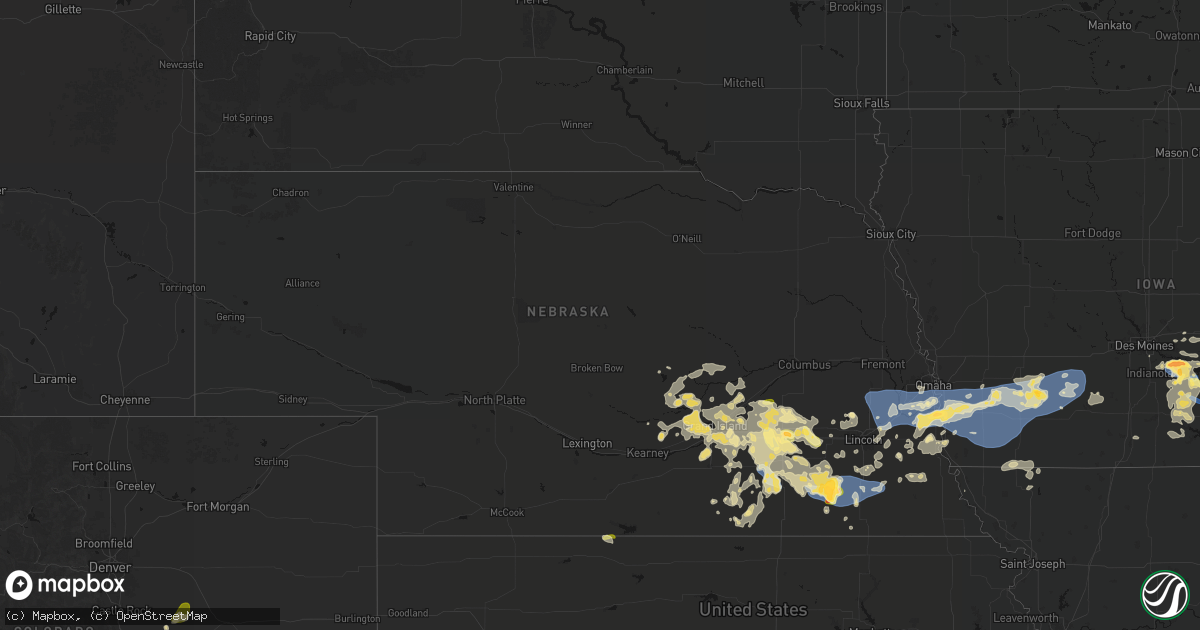
Hail Map in Nebraska on June 5, 2026
Get this storm
June 5 map
$229
one time, instant access
Download today. No call, no setup
Keep the $229
Bought the map and want the full workflow? Apply the entire $229 to a subscription within 7 days. None of it is wasted.
Every map, not just this one
This buys you this map. Subscription and you get every map we run, in the markets you choose from a few cities to whole states to nationwide. Plus real-time alerts the moment a storm fires.
Contact data
Name, contact info, occupancy, even credit band for addresses in the footprint. You go from where it hit to who to call.
Become the source they trust
Unlimited branding weather history reports on demand. You already have the documented answer ready for the property owner, and you are the one who showed up with it.
Property data and RoofTrace estimates
Pull up any address you have got, its value and the exact code rules for that jurisdiction, straight from One Click Code. Then RoofTrace estimates the squares, pitch, and roof value, priced the way you price.
Storm reports in Nebraska
Nebraska
| Date | Description |
|---|---|
| 06/05/20261:41 AM CDT | Corrects previous non-tstm wnd dmg report from 1 nnw strang. A delayed social media report of a blown over tractor trailer with image. |
| 06/05/20261:30 AM CDT | Via personal weather station. |
| 06/05/20261:30 AM CDT | Via personal weather station. May have had a gust as high as 76 mph a few minutes earlier... But considering this preliminary until other ground truth arrives from the |
| 06/05/20261:24 AM CDT | Via personal weather station. |
| 06/04/202611:52 PM CDT | Corrects previous tstm wnd dmg report from 2 sse western. Flattened crops on both sides of highway 15 near western. Updated radar estimated time. |
| 06/04/202611:51 PM CDT | Mesonet station ne057 auburn nebraska city. |
| 06/04/202611:17 PM CDT | Flattened crops on both sides of highway 15 near western. |
| 06/04/202610:31 PM CDT | Report of ping pong ball sized hail in york. |
| 06/04/202610:29 PM CDT | Report of quarter sized hail in york. |
| 06/04/202610:29 PM CDT | A local report indicates 67 MPH wind near 0.6 ESE Plymouth |
| 06/04/202610:16 PM CDT | Em shared photos of damage to a farm. Damage included a destroyed sheet metal outbuilding... Overturned irrigation pivot... Crop damage... And down trees in the area. T |
| 06/04/202610:15 PM CDT | A local report indicates 68 MPH wind near 2.7 WNW Plymouth |
| 06/04/202610:08 PM CDT | Personal weather station. |
| 06/04/202610:05 PM CDT | Personal weather station. |
| 06/04/202610:04 PM CDT | Personal weather station. |
| 06/04/202610:02 PM CDT | A local report indicates 1.75 inch wind near 2 WNW Plattsmouth |
| 06/04/202610:02 PM CDT | Damage to metal siding and a broken window at a residence as a result of wind-driven large hail. Location is approximate. |
| 06/04/20269:54 PM CDT | Personal weather station. |
| 06/04/20269:52 PM CDT | Report of large hail between union and murray... Ne using a tape measure. Time is estimated from radar. Location is approximate. |
| 06/04/20268:56 PM CDT | Personal weather station. |
| 06/04/20268:30 PM CDT | A local report indicates 1.00 inch wind near 1 SW Swanton |
| 06/04/20268:00 PM CDT | A local report indicates 1.75 inch wind near 3 S Swanton |
| 06/04/20267:58 PM CDT | Report from em relayed via nwschat. |
All States Impacted by Hail Map on June 5, 2026
Cities Impacted by Hail Map on June 5, 2026
- Long Prairie, MN
- Sauk Centre, MN
- Osakis, MN
- Mora, MN
- Altus, OK
- Headrick, OK
- Mountain Park, OK
- Brook Park, MN
- Grasston, MN
- Pine City, MN
- Gail, TX
- Hinckley, MN
- McCaulley, TX
- Hamlin, TX
- Danbury, WI
- Cleo Springs, OK
- Morton, TX
- Pecos, TX
- Coyanosa, TX
- Rogers, NM
- Canute, OK
- Pep, NM
- Barstow, TX
- Madison, MN
- Ames, OK
- Isabella, OK
- Ringwood, OK
- Morris, MN
- Hancock, MN
- Dawson, MN
- Sudan, TX
- Fairview, OK
- Boyd, MN
- Brandon, MN
- Milnesand, NM
- Cyrus, MN
- Granite Falls, MN
- Clarkfield, MN
- Starbuck, MN
- Benson, MN
- Clontarf, MN
- Alexandria, MN
- Garfield, MN
- Muleshoe, TX
- Rice Lake, WI
- Chester, OK
- Danvers, MN
- Hanley Falls, MN
- Glenwood, MN
- Las Vegas, NM
- Farwell, MN
- Arenas Valley, NM
- Carlos, MN
- Lowry, MN
- Villard, MN
- Memphis, TX
- Wood Lake, MN
- Murdock, MN
- Echo, MN
- Cornell, WI
- Holcombe, WI
- Conrath, WI
- Gould, OK
- Hollis, OK
- Alto, NM
- Ladysmith, WI
- Brooten, MN
- Tony, WI
- Gwinn, MI
- Ishpeming, MI
- Matador, TX
- Negaunee, MI
- Sheldon, WI
- Montevideo, MN
- Belgrade, MN
- Earth, TX
- Wellington, TX
- Maiden Rock, WI
- Orleans, NE
- Long Island, KS
- Phillipsburg, KS
- Stamford, NE
- Dimmitt, TX
- Lubbock, TX
- Plum City, WI
- Paynesville, MN
- Melrose, MN
- Pampa, TX
- Childress, TX
- Elbert, CO
- Scott City, KS
- Chillicothe, TX
- Calhan, CO
- Trementina, NM
- Agate, CO
- Ramah, CO
- Alma, WI
- Vernon, TX
- Nelson, WI
- Odell, TX
- Marienthal, KS
- Socorro, NM
- Plainview, TX
- Roswell, NM
- Cochrane, WI
- Arcadia, WI
- Hixton, WI
- Blair, WI
- Taylor, WI
- Independence, WI
- Polk, NE
- Fountain City, WI
- Black River Falls, WI
- Saint Libory, NE
- Grand Island, NE
- Hordville, NE
- Chapman, NE
- Stromsburg, NE
- Clarks, NE
- Garita, NM
- De Witt, NE
- Swanton, NE
- Central City, NE
- Canyon, TX
- Dryden, TX
- Stinnett, TX
- Amarillo, TX
- Minnesota City, MN
- Ohiowa, NE
- Ettrick, WI
- Galesville, WI
- Holmen, WI
- Trempealeau, WI
- Mindoro, WI
- Bangor, WI
- West Salem, WI
- Melrose, WI
- Dodge, WI
- Morse, TX
- Martell, NE
- Hickman, NE
- Firth, NE
- Western, NE
- Marquette, NE
- Bradshaw, NE
- Benedict, NE
- Alexandria, NE
- Tobias, NE
- Beatrice, NE
- Warrens, WI
- Winona, MN
- Wilber, NE
- Hampton, NE
- Plymouth, NE
- Sparta, WI
- Maljamar, NM
- Lake City, MN
- Phillips, NE
- Hallam, NE
- Staplehurst, NE
- Waco, NE
- Cortland, NE
- Dumas, TX
- Gresham, NE
- York, NE
- Hugo, CO
- Unadilla, NE
- Daykin, NE
- Crete, NE
- Dorchester, NE
- Stockholm, WI
- Otley, IA
- Aurora, NE
- Tomah, WI
- Norwalk, WI
- Wilton, WI
- Raymond, NE
- Valparaiso, NE
- Pella, IA
- Henderson, NE
- Palmyra, NE
- Pepin, WI
- Utica, NE
- Beaver Crossing, NE
- Durand, WI
- Arkansaw, WI
- McCool Junction, NE
- Kendall, WI
- Markesan, WI
- Bennet, NE
- Roca, NE
- Seward, NE
- Bee, NE
- Rock Port, MO
- Camp Douglas, WI
- Syracuse, NE
- Denton, NE
- Lincoln, NE
- Milligan, NE
- Walton, NE
- Dakota, MN
- Milford, NE
- Goehner, NE
- La Crosse, WI
- Onalaska, WI
- La Crescent, MN
- Avoca, NE
- Pleasant Dale, NE
- Fairmont, NE
- Geneva, NE
- Mauston, WI
- New Lisbon, WI
- Elroy, WI
- Otoe, NE
- Eagle, NE
- Jansen, NE
- Swan, IA
- Pleasantville, IA
- Orient, IA
- Exeter, NE
- Nehawka, NE
- Weeping Water, NE
- Ackworth, IA
- Hartford, IA
- Carlisle, IA
- Afton, IA
- Greenfield, IA
- Indianola, IA
- Malcolm, NE
- Garland, NE
- Elmwood, NE
- Houston, MN
- Friend, NE
- Louisville, NE
- Plattsmouth, NE
- Waverly, NE
- Nebraska City, NE
- Adams, NE
- Lorimor, IA
- Alvo, NE
- Greenwood, NE
- Murray, NE
- Ashland, NE
- Murdock, NE
- Union, NE
- Gretna, NE
- Gruver, TX
- Massena, IA
- Corning, IA
- Cumberland, IA
- Bridgewater, IA
- Springfield, NE
- Creston, IA
- Hokah, MN
- Coon Valley, WI
- Papillion, NE
- Cedar Creek, NE
- Pacific Junction, IA
- Bellevue, NE
- Chaseburg, WI
- Stoddard, WI
- Memphis, NE
- Wahoo, NE
- South Bend, NE
- Yutan, NE
- Ceresco, NE
- Ithaca, NE
- Mead, NE
- Colon, NE
- Fremont, NE
- Waterloo, NE
- Omaha, NE
- Elkhorn, NE
- La Vista, NE
- Boys Town, NE
- Offutt Afb, NE
- Council Bluffs, IA
- Manley, NE
- Glenwood, IA
- Clatonia, NE
- Pickrell, NE
- Mineola, IA
- Silver City, IA
- Treynor, IA
- Fairbury, NE
- Knoxville, IA
- Hastings, IA
- Henderson, IA
- Carson, IA
- Malvern, IA
- Macedonia, IA
- Melcher Dallas, IA
- Milo, IA
- Lacona, IA
- Panama, NE
- Dunbar, NE
- Griswold, IA
- Emerson, IA
- Villisca, IA
- Red Oak, IA
- Stanton, IA
- Elliott, IA
- Filley, NE
- Sidney, IA
- Thurman, IA
- Randolph, IA
- Imogene, IA
- Tabor, IA
- Essex, IA
- Atlantic, IA
- Grant, IA
- Lewis, IA
- Wiota, IA
- Oakland, IA
- Pleasanton, NE
- Ravenna, NE
- Burr, NE
- Sterling, NE
- Percival, IA
- Wolbach, NE
- Odell, NE
- Macksburg, IA
- Farragut, IA
- Shenandoah, IA
- Clarinda, IA
- Nodaway, IA
- Anita, IA
- Kearney, NE
- Gibbon, NE
- Cook, NE
- Monroe, IA
- Alda, NE
- Brock, NE
- Talmage, NE
- Belvidere, NC
- Tracy, IA
- Bussey, IA
- Giltner, NE
- Farwell, NE
- Columbia, IA
- Dannebrog, NE
- Fontanelle, IA
- Fullerton, NE
- Chariton, IA
- Palmer, NE
- Lovilia, IA
- Carbon, IA
- Dexter, IA
- Prescott, IA
- Stuart, IA
- Archer, NE
- Sutton, NE
- Grafton, NE
- Blanchard, IA
- Coin, IA
- Braddyville, IA
- College Springs, IA
- Cairo, NE
- Hamilton, IA
- Shelton, NE
- Wood River, NE
- Diller, NE
- Strang, NE
- Ridgeway, IA
- Cresco, IA
- Decorah, IA
- Saint Paul, NE
- Russell, IA
- Williamson, IA
- Elmo, MO
- Bedford, IA
- Clearmont, MO
- Hillsboro, WI
- Richland Center, WI
- Doniphan, NE
- Hopkins, MO
- New Market, IA
- Cary, IL
- Crystal Lake, IL
- Mchenry, IL
- North Loup, NE
- Cazenovia, WI
- Barrington, IL
- Island Lake, IL
- Wauconda, IL
- Melrose, IA
- Maryville, MO
- Lake Zurich, IL
- Pickering, MO
- New Albin, IA
- Dorchester, IA
- Loup City, NE
- Mitchellville, IA
- Prairie City, IA
- Lansing, IA
- Weldon, IA
- Shickley, NE
- Scotia, NE
- Elba, NE
- Rockville, NE
- Ashton, NE
- Colfax, IA
- Waukon, IA
- Newton, IA
- Hastings, NE
- Juniata, NE
- Corydon, IA
- Millerton, IA
- Trumbull, NE
- Harvard, NE
- Boelus, NE
- Monona, IA
- Bruning, NE
- Edgar, NE
- Promise City, IA
- Luana, IA
- Waterville, IA
- Harpers Ferry, IA
- Spearman, TX
- Malta, MT
- Inland, NE
- Saronville, NE
- Clay Center, NE
- Davenport, NE
- Fairfield, NE
- Aledo, IL
- Sherrard, IL
- Deweese, NE
- Orion, IL
- Nelson, NE
- Ong, NE
- Oak, NE
- Superior, NE
- Ruskin, NE
- Woodhull, IL
- Streator, IL
- Tonica, IL
- Matherville, IL
- La Crosse, IN
- Lynn Center, IL
- Lawrence, NE
- Varna, IL
- Toluca, IL
- Ophiem, IL
- Viola, IL
- New Windsor, IL
- Alpha, IL
- Hardy, NE
- Osco, IL
- Long Point, IL
- Minonk, IL
- Pontiac, IL
- Cornell, IL
- Flanagan, IL
- Cambridge, IL
- Geneseo, IL
- Galva, IL
- Blue Hill, NE
- Kewanee, IL
- Odell, IL
- Wolf Point, MT
- Wenona, IL
- Wilmington, IL
- Manteno, IL
- Saunemin, IL
- Cullom, IL
- Piper City, IL
- Kempton, IL
- Fairbury, IL
- Forrest, IL
- Ashkum, IL
- Chenoa, IL
- Guide Rock, NE
- Chatsworth, IL
- Graymont, IL
- Clifton, IL
- Fowler, IN
- Remington, IN
- Chalmers, IN
- Wolcott, IN
- Brookston, IN
- West Lafayette, IN


