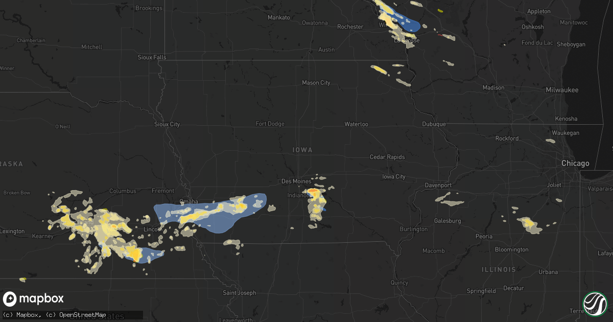
Hail Map in Iowa on June 5, 2026
Get this storm
June 5 map
$229
one time, instant access
Download today. No call, no setup
Keep the $229
Bought the map and want the full workflow? Apply the entire $229 to a subscription within 7 days. None of it is wasted.
Every map, not just this one
This buys you this map. Subscription and you get every map we run, in the markets you choose from a few cities to whole states to nationwide. Plus real-time alerts the moment a storm fires.
Contact data
Name, contact info, occupancy, even credit band for addresses in the footprint. You go from where it hit to who to call.
Become the source they trust
Unlimited branding weather history reports on demand. You already have the documented answer ready for the property owner, and you are the one who showed up with it.
Property data and RoofTrace estimates
Pull up any address you have got, its value and the exact code rules for that jurisdiction, straight from One Click Code. Then RoofTrace estimates the squares, pitch, and roof value, priced the way you price.
Storm reports in Iowa
Iowa
| Date | Description |
|---|---|
| 06/04/202611:59 PM CDT | Measured from personal weather station. |
| 06/04/202611:58 PM CDT | Measured from personal weather station. |
| 06/04/202611:40 PM CDT | Report from mping: quarter |
| 06/04/202611:39 PM CDT | Report from mping: quarter |
| 06/04/202611:35 PM CDT | 1-2 inch tree limbs down. |
| 06/04/202611:29 PM CDT | A local report indicates 60 MPH wind near 5.6 WSW Grant |
| 06/04/202611:18 PM CDT | Reports of power flashes and ping pong ball sized hail south of massena. |
| 06/04/202611:18 PM CDT | Measured from personal weather station. |
| 06/04/202611:10 PM CDT | Measured from personal weather station. |
| 06/04/202611:10 PM CDT | Trees uprooted. |
| 06/04/202611:01 PM CDT | Measured from personal weather station. |
| 06/04/202611:00 PM CDT | A local report indicates 60 MPH wind near 4 SE Malvern |
| 06/04/202611:00 PM CDT | Report of tree on house in pleasantville. Time estimated from radar. |
| 06/04/202611:00 PM CDT | Report of quarter size hail south of massena relayed via chat. |
| 06/04/202610:58 PM CDT | Em reported flattened corn east of thurman. Time is estimated from radar. |
| 06/04/202610:56 PM CDT | Delayed report - received hail photo from social media. |
| 06/04/202610:56 PM CDT | Em reported the department of roads was working on clearing trees from roads in the thurman area. Time is estimated from radar. |
| 06/04/202610:54 PM CDT | A local report indicates 59 MPH wind near 7.8 NE Emerson |
| 06/04/202610:50 PM CDT | Several large tree limbs down. |
| 06/04/202610:48 PM CDT | A local report indicates 69 MPH wind near 5.9 W Macedonia |
| 06/04/202610:45 PM CDT | A local report indicates 60 MPH wind near 1.9 NW Henderson |
| 06/04/202610:44 PM CDT | Photo of mature walnut tree uprooted west of macedonia. Time is estimated from radar. |
| 06/04/202610:40 PM CDT | A local report indicates 59 MPH wind near 3 NW Silver City |
| 06/04/202610:34 PM CDT | A local report indicates 59 MPH wind near 2.0 S Silver City |
| 06/04/202610:19 PM CDT | Personal weather station. |
| 06/04/202610:18 PM CDT | Report of no power at truckstop near glenwood exit. Winds were estimated to have been between 60-70 mph. |
| 06/04/202610:18 PM CDT | Report of quarter size hail near glenwood exit. |
| 06/04/202610:11 PM CDT | Received text message from trained spotter of 63mph gust on pws. |
| 06/04/202610:02 PM CDT | Received photo from media of golf ball sized hail. |
| 06/04/202610:02 PM CDT | Received phone call from trained spotter reporting golf ball sized hail in pleasantville. |
| 06/04/202610:00 PM CDT | Delayed report - relayed from broadcast media. Time estimated from radar. |
| 06/04/20269:59 PM CDT | Received phone call of tree branches down north of sandyville. |
| 06/04/20269:55 PM CDT | Received phone call from trained spotter reporting quarter sized hail falling in pleasantville. |
All States Impacted by Hail Map on June 5, 2026
Cities Impacted by Hail Map on June 5, 2026
- Long Prairie, MN
- Sauk Centre, MN
- Osakis, MN
- Mora, MN
- Altus, OK
- Headrick, OK
- Mountain Park, OK
- Brook Park, MN
- Grasston, MN
- Pine City, MN
- Gail, TX
- Hinckley, MN
- McCaulley, TX
- Hamlin, TX
- Danbury, WI
- Cleo Springs, OK
- Morton, TX
- Pecos, TX
- Coyanosa, TX
- Rogers, NM
- Canute, OK
- Pep, NM
- Barstow, TX
- Madison, MN
- Ames, OK
- Isabella, OK
- Ringwood, OK
- Morris, MN
- Hancock, MN
- Dawson, MN
- Sudan, TX
- Fairview, OK
- Boyd, MN
- Brandon, MN
- Milnesand, NM
- Cyrus, MN
- Granite Falls, MN
- Clarkfield, MN
- Starbuck, MN
- Benson, MN
- Clontarf, MN
- Alexandria, MN
- Garfield, MN
- Muleshoe, TX
- Rice Lake, WI
- Chester, OK
- Danvers, MN
- Hanley Falls, MN
- Glenwood, MN
- Las Vegas, NM
- Farwell, MN
- Arenas Valley, NM
- Carlos, MN
- Lowry, MN
- Villard, MN
- Memphis, TX
- Wood Lake, MN
- Murdock, MN
- Echo, MN
- Cornell, WI
- Holcombe, WI
- Conrath, WI
- Gould, OK
- Hollis, OK
- Alto, NM
- Ladysmith, WI
- Brooten, MN
- Tony, WI
- Gwinn, MI
- Ishpeming, MI
- Matador, TX
- Negaunee, MI
- Sheldon, WI
- Montevideo, MN
- Belgrade, MN
- Earth, TX
- Wellington, TX
- Maiden Rock, WI
- Orleans, NE
- Long Island, KS
- Phillipsburg, KS
- Stamford, NE
- Dimmitt, TX
- Lubbock, TX
- Plum City, WI
- Paynesville, MN
- Melrose, MN
- Pampa, TX
- Childress, TX
- Elbert, CO
- Scott City, KS
- Chillicothe, TX
- Calhan, CO
- Trementina, NM
- Agate, CO
- Ramah, CO
- Alma, WI
- Vernon, TX
- Nelson, WI
- Odell, TX
- Marienthal, KS
- Socorro, NM
- Plainview, TX
- Roswell, NM
- Cochrane, WI
- Arcadia, WI
- Hixton, WI
- Blair, WI
- Taylor, WI
- Independence, WI
- Polk, NE
- Fountain City, WI
- Black River Falls, WI
- Saint Libory, NE
- Grand Island, NE
- Hordville, NE
- Chapman, NE
- Stromsburg, NE
- Clarks, NE
- Garita, NM
- De Witt, NE
- Swanton, NE
- Central City, NE
- Canyon, TX
- Dryden, TX
- Stinnett, TX
- Amarillo, TX
- Minnesota City, MN
- Ohiowa, NE
- Ettrick, WI
- Galesville, WI
- Holmen, WI
- Trempealeau, WI
- Mindoro, WI
- Bangor, WI
- West Salem, WI
- Melrose, WI
- Dodge, WI
- Morse, TX
- Martell, NE
- Hickman, NE
- Firth, NE
- Western, NE
- Marquette, NE
- Bradshaw, NE
- Benedict, NE
- Alexandria, NE
- Tobias, NE
- Beatrice, NE
- Warrens, WI
- Winona, MN
- Wilber, NE
- Hampton, NE
- Plymouth, NE
- Sparta, WI
- Maljamar, NM
- Lake City, MN
- Phillips, NE
- Hallam, NE
- Staplehurst, NE
- Waco, NE
- Cortland, NE
- Dumas, TX
- Gresham, NE
- York, NE
- Hugo, CO
- Unadilla, NE
- Daykin, NE
- Crete, NE
- Dorchester, NE
- Stockholm, WI
- Otley, IA
- Aurora, NE
- Tomah, WI
- Norwalk, WI
- Wilton, WI
- Raymond, NE
- Valparaiso, NE
- Pella, IA
- Henderson, NE
- Palmyra, NE
- Pepin, WI
- Utica, NE
- Beaver Crossing, NE
- Durand, WI
- Arkansaw, WI
- McCool Junction, NE
- Kendall, WI
- Markesan, WI
- Bennet, NE
- Roca, NE
- Seward, NE
- Bee, NE
- Rock Port, MO
- Camp Douglas, WI
- Syracuse, NE
- Denton, NE
- Lincoln, NE
- Milligan, NE
- Walton, NE
- Dakota, MN
- Milford, NE
- Goehner, NE
- La Crosse, WI
- Onalaska, WI
- La Crescent, MN
- Avoca, NE
- Pleasant Dale, NE
- Fairmont, NE
- Geneva, NE
- Mauston, WI
- New Lisbon, WI
- Elroy, WI
- Otoe, NE
- Eagle, NE
- Jansen, NE
- Swan, IA
- Pleasantville, IA
- Orient, IA
- Exeter, NE
- Nehawka, NE
- Weeping Water, NE
- Ackworth, IA
- Hartford, IA
- Carlisle, IA
- Afton, IA
- Greenfield, IA
- Indianola, IA
- Malcolm, NE
- Garland, NE
- Elmwood, NE
- Houston, MN
- Friend, NE
- Louisville, NE
- Plattsmouth, NE
- Waverly, NE
- Nebraska City, NE
- Adams, NE
- Lorimor, IA
- Alvo, NE
- Greenwood, NE
- Murray, NE
- Ashland, NE
- Murdock, NE
- Union, NE
- Gretna, NE
- Gruver, TX
- Massena, IA
- Corning, IA
- Cumberland, IA
- Bridgewater, IA
- Springfield, NE
- Creston, IA
- Hokah, MN
- Coon Valley, WI
- Papillion, NE
- Cedar Creek, NE
- Pacific Junction, IA
- Bellevue, NE
- Chaseburg, WI
- Stoddard, WI
- Memphis, NE
- Wahoo, NE
- South Bend, NE
- Yutan, NE
- Ceresco, NE
- Ithaca, NE
- Mead, NE
- Colon, NE
- Fremont, NE
- Waterloo, NE
- Omaha, NE
- Elkhorn, NE
- La Vista, NE
- Boys Town, NE
- Offutt Afb, NE
- Council Bluffs, IA
- Manley, NE
- Glenwood, IA
- Clatonia, NE
- Pickrell, NE
- Mineola, IA
- Silver City, IA
- Treynor, IA
- Fairbury, NE
- Knoxville, IA
- Hastings, IA
- Henderson, IA
- Carson, IA
- Malvern, IA
- Macedonia, IA
- Melcher Dallas, IA
- Milo, IA
- Lacona, IA
- Panama, NE
- Dunbar, NE
- Griswold, IA
- Emerson, IA
- Villisca, IA
- Red Oak, IA
- Stanton, IA
- Elliott, IA
- Filley, NE
- Sidney, IA
- Thurman, IA
- Randolph, IA
- Imogene, IA
- Tabor, IA
- Essex, IA
- Atlantic, IA
- Grant, IA
- Lewis, IA
- Wiota, IA
- Oakland, IA
- Pleasanton, NE
- Ravenna, NE
- Burr, NE
- Sterling, NE
- Percival, IA
- Wolbach, NE
- Odell, NE
- Macksburg, IA
- Farragut, IA
- Shenandoah, IA
- Clarinda, IA
- Nodaway, IA
- Anita, IA
- Kearney, NE
- Gibbon, NE
- Cook, NE
- Monroe, IA
- Alda, NE
- Brock, NE
- Talmage, NE
- Belvidere, NC
- Tracy, IA
- Bussey, IA
- Giltner, NE
- Farwell, NE
- Columbia, IA
- Dannebrog, NE
- Fontanelle, IA
- Fullerton, NE
- Chariton, IA
- Palmer, NE
- Lovilia, IA
- Carbon, IA
- Dexter, IA
- Prescott, IA
- Stuart, IA
- Archer, NE
- Sutton, NE
- Grafton, NE
- Blanchard, IA
- Coin, IA
- Braddyville, IA
- College Springs, IA
- Cairo, NE
- Hamilton, IA
- Shelton, NE
- Wood River, NE
- Diller, NE
- Strang, NE
- Ridgeway, IA
- Cresco, IA
- Decorah, IA
- Saint Paul, NE
- Russell, IA
- Williamson, IA
- Elmo, MO
- Bedford, IA
- Clearmont, MO
- Hillsboro, WI
- Richland Center, WI
- Doniphan, NE
- Hopkins, MO
- New Market, IA
- Cary, IL
- Crystal Lake, IL
- Mchenry, IL
- North Loup, NE
- Cazenovia, WI
- Barrington, IL
- Island Lake, IL
- Wauconda, IL
- Melrose, IA
- Maryville, MO
- Lake Zurich, IL
- Pickering, MO
- New Albin, IA
- Dorchester, IA
- Loup City, NE
- Mitchellville, IA
- Prairie City, IA
- Lansing, IA
- Weldon, IA
- Shickley, NE
- Scotia, NE
- Elba, NE
- Rockville, NE
- Ashton, NE
- Colfax, IA
- Waukon, IA
- Newton, IA
- Hastings, NE
- Juniata, NE
- Corydon, IA
- Millerton, IA
- Trumbull, NE
- Harvard, NE
- Boelus, NE
- Monona, IA
- Bruning, NE
- Edgar, NE
- Promise City, IA
- Luana, IA
- Waterville, IA
- Harpers Ferry, IA
- Spearman, TX
- Malta, MT
- Inland, NE
- Saronville, NE
- Clay Center, NE
- Davenport, NE
- Fairfield, NE
- Aledo, IL
- Sherrard, IL
- Deweese, NE
- Orion, IL
- Nelson, NE
- Ong, NE
- Oak, NE
- Superior, NE
- Ruskin, NE
- Woodhull, IL
- Streator, IL
- Tonica, IL
- Matherville, IL
- La Crosse, IN
- Lynn Center, IL
- Lawrence, NE
- Varna, IL
- Toluca, IL
- Ophiem, IL
- Viola, IL
- New Windsor, IL
- Alpha, IL
- Hardy, NE
- Osco, IL
- Long Point, IL
- Minonk, IL
- Pontiac, IL
- Cornell, IL
- Flanagan, IL
- Cambridge, IL
- Geneseo, IL
- Galva, IL
- Blue Hill, NE
- Kewanee, IL
- Odell, IL
- Wolf Point, MT
- Wenona, IL
- Wilmington, IL
- Manteno, IL
- Saunemin, IL
- Cullom, IL
- Piper City, IL
- Kempton, IL
- Fairbury, IL
- Forrest, IL
- Ashkum, IL
- Chenoa, IL
- Guide Rock, NE
- Chatsworth, IL
- Graymont, IL
- Clifton, IL
- Fowler, IN
- Remington, IN
- Chalmers, IN
- Wolcott, IN
- Brookston, IN
- West Lafayette, IN


