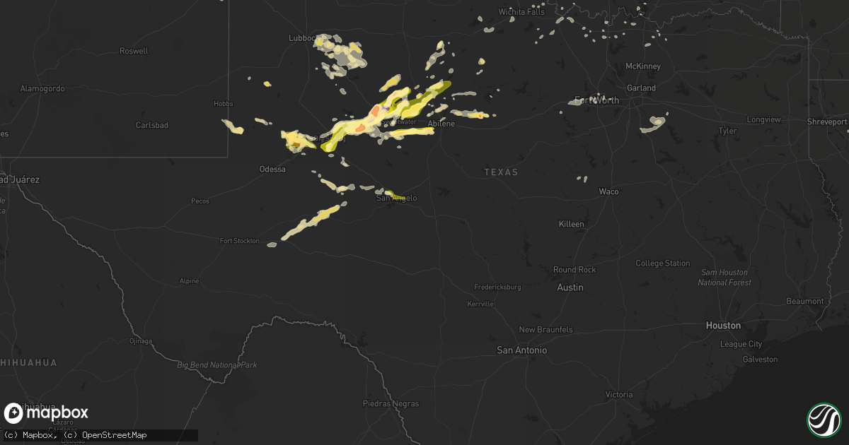
Hail Map in Texas on June 5, 2013
Get this storm
June 5 map
$229
one time, instant access
Download today. No call, no setup
Keep the $229
Bought the map and want the full workflow? Apply the entire $229 to a subscription within 7 days. None of it is wasted.
Every map, not just this one
This buys you this map. Subscription and you get every map we run, in the markets you choose from a few cities to whole states to nationwide. Plus real-time alerts the moment a storm fires.
Contact data
Name, contact info, occupancy, even credit band for addresses in the footprint. You go from where it hit to who to call.
Become the source they trust
Unlimited branding weather history reports on demand. You already have the documented answer ready for the property owner, and you are the one who showed up with it.
Property data and RoofTrace estimates
Pull up any address you have got, its value and the exact code rules for that jurisdiction, straight from One Click Code. Then RoofTrace estimates the squares, pitch, and roof value, priced the way you price.
Storm reports in Texas
Texas
| Date | Description |
|---|---|
| 06/05/20136:30 PM CDT | A local report indicates 60 MPH wind near 26 NNE BIG LAKE |
| 06/05/20136:00 PM CDT | A local report indicates 68 MPH wind near 5 SW ST. LAWRENCE |
| 06/05/20136:45 AM CDT | 3-inch tree limbs blown down in the city of terrell |
| 06/05/20131:30 AM CDT | Limbs down along county road 654. Shingles removed from roof. |
| 06/05/20131:21 AM CDT | A local report indicates 61 MPH wind near 3 ESE ABILENE |
| 06/05/201312:40 AM CDT | Trees and power lines reported down in sweetwater. |
| 06/05/201312:27 AM CDT | A local report indicates 1.00 inch wind near WHITE RIVER LAKE |
| 06/05/201312:20 AM CDT | Powerline down on east lee street |
| 06/05/201312:10 AM CDT | A local report indicates 72 MPH wind near 3 E SNYDER |
| 06/05/201312:05 AM CDT | Reported by west texas mesonet |
| 06/05/201312:05 AM CDT | Several 3 inch diameter limbs about 10 feet long blown down on the nw side of breckenridge. |
| 06/05/201312:00 AM CDT | A local report indicates 66 MPH wind near 6 SSW WOLFFORTH |
| 06/05/201312:00 AM CDT | A local report indicates 60 MPH wind near 5 NW SNYDER |
| 06/04/201311:46 PM CDT | A local report indicates 62 MPH wind near MIDLAND INTERNATIONAL A |
| 06/04/201311:45 PM CDT | A local report indicates 64 MPH wind near 1 N O'DONNELL |
| 06/04/201311:43 PM CDT | A local report indicates 62 MPH wind near MIDLAND INTERNATIONAL A |
| 06/04/201311:40 PM CDT | A local report indicates 70 MPH wind near 3 WNW FLUVANNA |
| 06/04/201311:40 PM CDT | A local report indicates 62 MPH wind near 1 NW LAKE ALAN HENRY |
| 06/04/201311:30 PM CDT | Large tree down in albany |
| 06/04/201311:30 PM CDT | Public reported storage shed was destroyed by winds. Estimated time of occurence is 1130 to 1145 pm cdt |
| 06/04/201311:29 PM CDT | A local report indicates 77 MPH wind near 6 NE LUBBOCK |
| 06/04/201311:25 PM CDT | A local report indicates 1.75 inch wind near 2 E MORAN |
| 06/04/201311:25 PM CDT | Large oak tree down in moran |
| 06/04/201311:05 PM CDT | A local report indicates 74 MPH wind near 6 SSW ANTON |
| 06/04/201311:05 PM CDT | From west texas mesonet |
| 06/04/201311:00 PM CDT | A local report indicates 58 MPH wind near REESE CENTER |
| 06/04/201311:00 PM CDT | At the intersection e of slide and marsha sharp without power... Broken tree limbs. At 28th and boston broken windows on e and n sides due to hail... And blown down woo |
| 06/04/201311:00 PM CDT | North side of barn destroyed between 1100-1130 pm cdt. |
| 06/04/201311:00 PM CDT | A local report indicates 62 MPH wind near 3 NNE TAHOKA |
| 06/04/201311:00 PM CDT | A local report indicates 59 MPH wind near 1 ENE MORTON |
| 06/04/201311:00 PM CDT | Roof blown off of barn. |
| 06/04/201311:00 PM CDT | A local report indicates 60 MPH wind near STAMFORD |
| 06/04/201311:00 PM CDT | A local report indicates 1.00 inch wind near STAMFORD |
| 06/04/201311:00 PM CDT | A local report indicates 70 MPH wind near 6 SSW ANTON |
| 06/04/201310:55 PM CDT | A local report indicates 75 MPH wind near 6 SSW ANTON |
| 06/04/201310:50 PM CDT | A local report indicates 82 MPH wind near 2 NE SLATON |
| 06/04/201310:50 PM CDT | Five power poles snapped along highway 62. Time estimated. |
| 06/04/201310:50 PM CDT | A local report indicates 1.00 inch wind near STAMFORD |
| 06/04/201310:45 PM CDT | A local report indicates 62 MPH wind near 2 NNE SEMINOLE |
| 06/04/201310:45 PM CDT | A local report indicates 1.25 inch wind near STAMFORD |
| 06/04/201310:40 PM CDT | A local report indicates 60 MPH wind near 6 S OLTON |
| 06/04/201310:40 PM CDT | A local report indicates 60 MPH wind near 4 N HAWLEY |
| 06/04/201310:40 PM CDT | A local report indicates 67 MPH wind near REESE CENTER |
| 06/04/201310:38 PM CDT | A local report indicates 58 MPH wind near 1 SW SEAGRAVES |
| 06/04/201310:35 PM CDT | A local report indicates 1.00 inch wind near 1 E HAWLEY |
| 06/04/201310:35 PM CDT | Radio tower blown down onto fire department |
| 06/04/201310:35 PM CDT | A local report indicates 68 MPH wind near 1 ENE MORTON |
| 06/04/201310:35 PM CDT | Several trees blown down and windows broken across the texas tech university campus. |
| 06/04/201310:34 PM CDT | A local report indicates 84 MPH wind near 6 SSW WOLFFORTH |
| 06/04/201310:31 PM CDT | Visilibility severly restricted. |
| 06/04/201310:31 PM CDT | A local report indicates 72 MPH wind near 4 SSW LUBBOCK |
| 06/04/201310:30 PM CDT | Substantial roof damage to apartment complex. |
| 06/04/201310:30 PM CDT | A local report indicates 75 MPH wind near 6 SSW WOLFFORTH |
| 06/04/201310:30 PM CDT | Roof material was blown off of west side of high school...a few trees were toppled...power lines down...several carports turned over...siding on home was removed...and |
| 06/04/201310:30 PM CDT | Several trees blown down...power lines down...and several carports turned over |
| 06/04/201310:20 PM CDT | A local report indicates 1.50 inch wind near FRANKEL CITY |
| 06/04/201310:15 PM CDT | A local report indicates 81 MPH wind near REESE CENTER |
| 06/04/201310:15 PM CDT | A local report indicates 63 MPH wind near 1 ENE MORTON |
| 06/04/201310:15 PM CDT | A local report indicates 60 MPH wind near 7 WNW DENVER CITY |
| 06/04/201310:11 PM CDT | Poor visibility |
| 06/04/201310:10 PM CDT | Window screens were shredded. Time estimated by radar |
| 06/04/201310:10 PM CDT | A local report indicates 1.75 inch wind near ROTAN |
| 06/04/201310:07 PM CDT | A local report indicates 1.00 inch wind near ROTAN |
| 06/04/201310:07 PM CDT | A local report indicates 75 MPH wind near ROTAN |
| 06/04/201310:05 PM CDT | A local report indicates 69 MPH wind near 3 N PLAINS |
| 06/04/201310:05 PM CDT | A local report indicates 65 MPH wind near 1 ENE MORTON |
| 06/04/201310:05 PM CDT | A local report indicates 68 MPH wind near 6 SSW ANTON |
| 06/04/201310:05 PM CDT | A local report indicates 66 MPH wind near 4 S LEVELLAND |
| 06/04/201310:00 PM CDT | A local report indicates 67 MPH wind near 6 SSW ANTON |
| 06/04/201310:00 PM CDT | A local report indicates 1.75 inch wind near 3 N ROBY |
| 06/04/201310:00 PM CDT | A local report indicates 1.75 inch wind near 4 S ROBY |
| 06/04/201310:00 PM CDT | A local report indicates 76 MPH wind near 4 S LEVELLAND |
| 06/04/20139:55 PM CDT | A local report indicates 1.75 inch wind near 1 S ROBY |
| 06/04/20139:50 PM CDT | A local report indicates 67 MPH wind near 3 N PLAINS |
| 06/04/20139:45 PM CDT | A local report indicates 60 MPH wind near 2 SSW MULESHOE |
| 06/04/20139:40 PM CDT | Roof barn was blown off on county road 351 |
| 06/04/20139:33 PM CDT | Several 8 inch diameter by 10-12 feet long limbs down. |
| 06/04/20139:30 PM CDT | Public reported storage shed was destroyed by winds. Estimated time of occurence is 2130 to 2145 cdt |
| 06/04/20139:30 PM CDT | A local report indicates 72 MPH wind near 1 ENE MORTON |
| 06/04/20139:27 PM CDT | Report from social media |
| 06/04/20139:22 PM CDT | A local report indicates 2.00 inch wind near 3 W SPRINGLAKE |
| 06/04/20139:20 PM CDT | A local report indicates 1.00 inch wind near COLORADO CITY |
| 06/04/20139:10 PM CDT | Car port and small trailer house sustained significant damage on the morrow ranch |
| 06/04/20139:04 PM CDT | Golf ball size hail on highway 70 |
| 06/04/20138:54 PM CDT | Winshield was shattered. |
| 06/04/20138:49 PM CDT | Limbs being ripped from trees with penny sized hail. |
| 06/04/20138:45 PM CDT | A local report indicates 70 MPH wind near WESTBROOK |
| 06/04/20138:45 PM CDT | Hail between golf ball and egg size |
| 06/04/20138:45 PM CDT | Utility pole down in rowena |
| 06/04/20138:45 PM CDT | Police cruiser had windshield busted out due to the hail. |
| 06/04/20138:34 PM CDT | A local report indicates 1.75 inch wind near FRIONA |
| 06/04/20138:30 PM CDT | A local report indicates 63 MPH wind near 2 NE FRIONA |
| 06/04/20138:30 PM CDT | A local report indicates 1.00 inch wind near TARZAN |
| 06/04/20138:28 PM CDT | A local report indicates 1.75 inch wind near FRIONA |
| 06/04/20138:27 PM CDT | A local report indicates 1.00 inch wind near LEES |
| 06/04/20138:25 PM CDT | 1.2 inches of rain in 30 minutes measured |
| 06/04/20138:15 PM CDT | A local report indicates 60 MPH wind near 2 NE FRIONA |
| 06/04/20138:07 PM CDT | Golf ball sized hail is covering the ground |
| 06/04/20138:07 PM CDT | Golf ball sized hail is covering the ground |
| 06/04/20138:01 PM CDT | A local report indicates 1.75 inch wind near TARZAN |
| 06/04/20138:00 PM CDT | Hail occurred between 800-830 pm cdt. |
| 06/04/20138:00 PM CDT | Quarter size hail reported near pierce and beauregard |
| 06/04/20138:00 PM CDT | 30 foot tree down on louise drive |
| 06/04/20137:50 PM CDT | A local report indicates 59 MPH wind near 7 N BOOTLEG |
| 06/04/20137:38 PM CDT | 6 miles north of intersection of arden road and fm 2288 |
| 06/04/20137:38 PM CDT | 6 miles north of intersection of arden road and fm 2288 |
All States Impacted by Hail Map on June 5, 2013
Cities Impacted by Hail Map on June 5, 2013
- Encino, NM
- Sweetwater, TX
- Trent, TX
- Merkel, TX
- Rule, TX
- Amory, MS
- Smithville, MS
- Charleston, MS
- Tutwiler, MS
- Vaughn, NM
- Conchas Dam, NM
- Mosquero, NM
- Hollandale, MS
- Atlanta, GA
- Andrews, TX
- Friona, TX
- Broadview, NM
- Texico, NM
- Garden City, TX
- Baldwyn, MS
- Muleshoe, TX
- Albany, TX
- Courtland, MS
- Batesville, MS
- Aberdeen, MS
- Ringling, OK
- Healdton, OK
- Dubach, LA
- Sterling City, TX
- Big Lake, TX
- Tarzan, TX
- Stanton, TX
- Stanley, NM
- Rotan, TX
- Aspermont, TX
- Jayton, TX
- Abilene, TX
- Stamford, TX
- Big Spring, TX
- Coahoma, TX
- West Memphis, AR
- Earle, AR
- Crawfordsville, AR
- Turrell, AR
- Marion, AR
- Hermleigh, TX
- Heflin, LA
- McCaulley, TX
- Hamlin, TX
- Roby, TX
- Roy, NM
- Moran, TX
- Fort Stockton, TX
- Valley Mills, TX
- Springlake, TX
- Earth, TX
- Tyronza, AR
- Grady, NM
- Holly Springs, MS
- Waterford, MS
- West Monroe, LA
- Calhoun, LA
- Eros, LA
- Bard, NM
- Nauvoo, AL
- Lynn, AL
- Justiceburg, TX
- Post, TX
- Hampton, AR
- Camden, AR
- Portales, NM
- Oakland, MS
- Cisco, TX
- Midkiff, TX
- Ozona, TX
- Raton, NM
- Olton, TX
- Newellton, LA
- Corona, NM
- Tiptonville, TN
- Union City, TN
- Jonesboro, AR
- Oneonta, AL
- Blountsville, AL
- Altoona, AL
- Colorado City, TX
- Westbrook, TX
- Gleason, TN
- Dresden, TN
- Manchester, TN
- Winnsboro, LA
- Des Moines, NM
- Alexandria, LA
- Santa Fe, NM
- Rochester, TX
- Spur, TX
- Sardis, MS
- O'Brien, TX
- Saline, LA
- Ashland, LA
- Castor, LA
- Farwell, TX
- Logan, NM
- San Jon, NM
- Dimmitt, TX
- Tucumcari, NM
- Plainview, TX
- Hart, TX
- Hereford, TX
- Hale Center, TX
- Bovina, TX
- Fieldton, TX
- Saint Jo, TX
- Knox City, TX
- Munday, TX
- Cascilla, MS
- Haleyville, AL
- Double Springs, AL
- Fisher, AR
- Cherry Valley, AR
- Weiner, AR
- Harrisburg, AR
- Anson, TX
- Sylvester, TX
- Willard, NM
- Coushatta, LA
- Denison, TX
- Solano, NM
- Hawley, TX
- Clovis, NM
- Grenada, MS
- Duck Hill, MS
- McCarley, MS
- Ryan, OK
- Loop, TX
- Brownfield, TX
- Pell City, AL
- Odenville, AL
- Ruston, LA
- Kaufman, TX
- Roscoe, TX
- Fluvanna, TX
- Natchitoches, LA
- Cherokee, AL
- Avoca, TX
- Ragland, AL
- Scurry, TX
- Loraine, TX
- Maryneal, TX
- Haltom City, TX
- Fort Worth, TX
- Weinert, TX
- Coffeeville, MS
- Haskell, TX
- Ira, TX
- Las Vegas, NM
- Sapello, NM
- Naval Air Station Jrb, TX
- Taiban, NM
- Hamilton, AL
- Detroit, AL
- Nolan, TX
- Crosbyton, TX
- Athens, TN
- Riceville, TN
- Winnfield, LA
- Talbott, TN
- Jefferson City, TN
- Potts Camp, MS
- Ocate, NM
- Enid, MS
- Lambert, MS
- Gobler, MO
- Steele, MO
- Readyville, TN
- Woodbury, TN
- Christiana, TN
- Bradyville, TN
- Beechgrove, TN
- Tuscumbia, AL
- Atlanta, LA
- Booneville, MS
- Eunice, NM
- Menlo, GA
- Throckmorton, TX
- Normandy, TN
- Wartrace, TN
- Tullahoma, TN
- Amherst, TX
- Sudan, TX
- Ringgold, LA
- Gainesville, TX
- Memphis, TN
- Tupelo, MS
- Newport, AR
- Tuckerman, AR
- West Point, MS
- Prairie, MS
- Breckenridge, TX
- Whitesboro, TX
- Stuttgart, AR
- Slaton, TX
- Denver City, TX
- Ralls, TX
- Mertzon, TX
- Columbia, LA
- Muenster, TX
- Forestburg, TX
- Farmerville, LA
- Sterlington, LA
- Bastrop, LA
- Monroe, LA
- Collinston, LA
- Fayette, AL
- Snyder, TX
- Amagon, AR
- Cash, AR
- Natchez, LA
- Cosby, TN
- Florien, LA
- Lindsay, TX
- Prattville, AL
- Magee, MS
- Colfax, LA
- Montgomery, LA
- Quitman, LA
- Water Valley, MS
- Midland, TX
- Trementina, NM
- Savoy, TX
- Nettleton, MS
- Florence, AL
- Mathiston, MS
- Eupora, MS
- Mer Rouge, LA
- Marietta, MS
- Sunflower, MS
- Doddsville, MS
- Wichita Falls, TX
- Holliday, TX
- Olla, LA
- Moriarty, NM
- Petrolia, TX
- Tchula, MS
- Belzoni, MS
- Henrietta, TX
- Lorenzo, TX
- Ransom Canyon, TX
- San Angelo, TX
- Nocona, TX
- Fort Sumner, NM
- Rolling Fork, MS
- Oak Ridge, LA
- Piedmont, AL
- Leesburg, AL
- Gadsden, AL
- Centre, AL
- Lake Providence, LA
- Lake Village, AR
- Eudora, AR
- Tremont, MS
- Greenwood Springs, MS
- Birmingham, AL
- Arlington, TX
- Byhalia, MS
- Tillatoba, MS
- Sherman, TX
- Van Alstyne, TX
- Whitewright, TX
- Heflin, AL
- Steens, MS
- Horton, AL
- Guntersville, AL
- Russellville, AL
- Bellevue, TX
- Chatham, LA
- Sikes, LA
- Grayson, LA
- Geraldine, AL
- Rociada, NM
- Madisonville, TN
- Sweetwater, TN
- Kingston, OK
- Monett, MO
- Sevierville, TN
- Cedarbluff, MS
- Pheba, MS
- Hickman, KY
- Troy, TN
- Summerville, GA
- Pinson, AL
- Trussville, AL
- Jasper, AL
- Tahoka, TX
- Thackerville, OK
- Blackwell, TX
- Seagraves, TX
- Aledo, TX
- Weatherford, TX
- Carlsbad, TX
- Ackerman, MS
- Kemp, TX
- Ennis, TX
- Rosser, TX
- Etowah, TN
- Humphrey, AR
- Pontotoc, MS
- Red Banks, MS
- Lamar, MS
- Lewisburg, TN
- Shelbyville, TN
- Iraan, TX
- Winona, MS
- Bell Buckle, TN
- Woodson, TX
- Elm Grove, LA
- Dubberly, LA
- Jamestown, LA
- Sibley, LA
- Gladstone, NM
- Leland, MS
- Vicksburg, MS
- Guadalupita, NM
- Seymour, TX
- Pecos, NM
- Greenville, MS
- Moody, AL
- Bells, TX
- Lexington, MS
- Pope, MS
- Aliceville, AL
- Brookland, AR
- Bono, AR
- Wentworth, MO
- Estill Springs, TN
- Winchester, TN
- Sadler, TX
- Pottsboro, TX
- Clifton, TX
- Crenshaw, MS
- Delhi, LA
- Hazen, AR
- Jonesboro, LA
- Dodson, LA
- Bearden, AR
- Bienville, LA
- Iowa Park, TX
- Mead, OK
- Lubbock, TX
- Delta, AL
- Shannon, MS
- Talladega, AL
- Maryville, TN
- Vernon, TX
- Jones, LA
- Ringgold, TX
- Pineville, LA
- Ashland, AL
- Okolona, MS
- Houlka, MS
- Shaw, MS
- Signal Mountain, TN
- Star City, AR
- Monticello, KY
- Cimarron, NM
- Bonham, TX
- Tye, TX
- Yazoo City, MS
- Hamburg, AR
- Campti, LA
- Thorn Hill, TN
- Plantersville, MS
- Verona, MS
- Fackler, AL
- Stevenson, AL
- Bridgeport, AL
- Prentiss, MS
- Mount Olive, MS
- Santa Rosa, NM
- Vina, AL
- Red Bay, AL
- Pine Bluff, AR
- Montezuma, NM
- Rockford, TN
- Jasper, TN
- Sequatchie, TN
- Whitwell, TN
- Gaylesville, AL
- Mentone, AL
- Quitman, MS
- Jena, LA
- Gilmore, AR
- Lueders, TX


