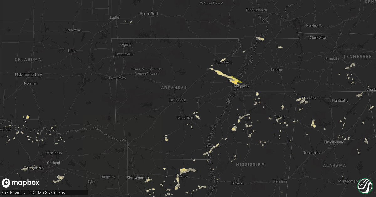
Hail Map in Arkansas on June 5, 2013
Get this storm
June 5 map
$229
one time, instant access
Download today. No call, no setup
Keep the $229
Bought the map and want the full workflow? Apply the entire $229 to a subscription within 7 days. None of it is wasted.
Every map, not just this one
This buys you this map. Subscription and you get every map we run, in the markets you choose from a few cities to whole states to nationwide. Plus real-time alerts the moment a storm fires.
Contact data
Name, contact info, occupancy, even credit band for addresses in the footprint. You go from where it hit to who to call.
Become the source they trust
Unlimited branding weather history reports on demand. You already have the documented answer ready for the property owner, and you are the one who showed up with it.
Property data and RoofTrace estimates
Pull up any address you have got, its value and the exact code rules for that jurisdiction, straight from One Click Code. Then RoofTrace estimates the squares, pitch, and roof value, priced the way you price.
Storm reports in Arkansas
Arkansas
| Date | Description |
|---|---|
| 06/05/20136:40 PM CDT | Severe winds downed a powerline...several billboard...and several business signs. Roofs also reported off of warehouse buildings. Powerpoles snapped northwest and south |
| 06/04/20138:05 PM CDT | Funnel clouds descended into a tornado just west of the mississippi river as reported by a trained storm spotter. This tornado moved east onto the mississippi river. Th |
| 06/04/20137:55 PM CDT | Golfball sized hail reported by trained weather spotter. |
| 06/04/20137:50 PM CDT | A large tree down on an automobile in jericho...due to damaging winds. |
| 06/04/20137:50 PM CDT | Quarter size hail in jericho. |
| 06/04/20137:45 PM CDT | Large pivot on irrigation system broken up from high winds near mile marker 17 on interstate 55. |
| 06/04/20137:38 PM CDT | Quarter size hail reported at mile marker 18 along interstate 55 approximately 1 mile north of jericho. |
All States Impacted by Hail Map on June 5, 2013
Cities Impacted by Hail Map on June 5, 2013
- Encino, NM
- Sweetwater, TX
- Trent, TX
- Merkel, TX
- Rule, TX
- Amory, MS
- Smithville, MS
- Charleston, MS
- Tutwiler, MS
- Vaughn, NM
- Conchas Dam, NM
- Mosquero, NM
- Hollandale, MS
- Atlanta, GA
- Andrews, TX
- Friona, TX
- Broadview, NM
- Texico, NM
- Garden City, TX
- Baldwyn, MS
- Muleshoe, TX
- Albany, TX
- Courtland, MS
- Batesville, MS
- Aberdeen, MS
- Ringling, OK
- Healdton, OK
- Dubach, LA
- Sterling City, TX
- Big Lake, TX
- Tarzan, TX
- Stanton, TX
- Stanley, NM
- Rotan, TX
- Aspermont, TX
- Jayton, TX
- Abilene, TX
- Stamford, TX
- Big Spring, TX
- Coahoma, TX
- West Memphis, AR
- Earle, AR
- Crawfordsville, AR
- Turrell, AR
- Marion, AR
- Hermleigh, TX
- Heflin, LA
- McCaulley, TX
- Hamlin, TX
- Roby, TX
- Roy, NM
- Moran, TX
- Fort Stockton, TX
- Valley Mills, TX
- Springlake, TX
- Earth, TX
- Tyronza, AR
- Grady, NM
- Holly Springs, MS
- Waterford, MS
- West Monroe, LA
- Calhoun, LA
- Eros, LA
- Bard, NM
- Nauvoo, AL
- Lynn, AL
- Justiceburg, TX
- Post, TX
- Hampton, AR
- Camden, AR
- Portales, NM
- Oakland, MS
- Cisco, TX
- Midkiff, TX
- Ozona, TX
- Raton, NM
- Olton, TX
- Newellton, LA
- Corona, NM
- Tiptonville, TN
- Union City, TN
- Jonesboro, AR
- Oneonta, AL
- Blountsville, AL
- Altoona, AL
- Colorado City, TX
- Westbrook, TX
- Gleason, TN
- Dresden, TN
- Manchester, TN
- Winnsboro, LA
- Des Moines, NM
- Alexandria, LA
- Santa Fe, NM
- Rochester, TX
- Spur, TX
- Sardis, MS
- O'Brien, TX
- Saline, LA
- Ashland, LA
- Castor, LA
- Farwell, TX
- Logan, NM
- San Jon, NM
- Dimmitt, TX
- Tucumcari, NM
- Plainview, TX
- Hart, TX
- Hereford, TX
- Hale Center, TX
- Bovina, TX
- Fieldton, TX
- Saint Jo, TX
- Knox City, TX
- Munday, TX
- Cascilla, MS
- Haleyville, AL
- Double Springs, AL
- Fisher, AR
- Cherry Valley, AR
- Weiner, AR
- Harrisburg, AR
- Anson, TX
- Sylvester, TX
- Willard, NM
- Coushatta, LA
- Denison, TX
- Solano, NM
- Hawley, TX
- Clovis, NM
- Grenada, MS
- Duck Hill, MS
- McCarley, MS
- Ryan, OK
- Loop, TX
- Brownfield, TX
- Pell City, AL
- Odenville, AL
- Ruston, LA
- Kaufman, TX
- Roscoe, TX
- Fluvanna, TX
- Natchitoches, LA
- Cherokee, AL
- Avoca, TX
- Ragland, AL
- Scurry, TX
- Loraine, TX
- Maryneal, TX
- Haltom City, TX
- Fort Worth, TX
- Weinert, TX
- Coffeeville, MS
- Haskell, TX
- Ira, TX
- Las Vegas, NM
- Sapello, NM
- Naval Air Station Jrb, TX
- Taiban, NM
- Hamilton, AL
- Detroit, AL
- Nolan, TX
- Crosbyton, TX
- Athens, TN
- Riceville, TN
- Winnfield, LA
- Talbott, TN
- Jefferson City, TN
- Potts Camp, MS
- Ocate, NM
- Enid, MS
- Lambert, MS
- Gobler, MO
- Steele, MO
- Readyville, TN
- Woodbury, TN
- Christiana, TN
- Bradyville, TN
- Beechgrove, TN
- Tuscumbia, AL
- Atlanta, LA
- Booneville, MS
- Eunice, NM
- Menlo, GA
- Throckmorton, TX
- Normandy, TN
- Wartrace, TN
- Tullahoma, TN
- Amherst, TX
- Sudan, TX
- Ringgold, LA
- Gainesville, TX
- Memphis, TN
- Tupelo, MS
- Newport, AR
- Tuckerman, AR
- West Point, MS
- Prairie, MS
- Breckenridge, TX
- Whitesboro, TX
- Stuttgart, AR
- Slaton, TX
- Denver City, TX
- Ralls, TX
- Mertzon, TX
- Columbia, LA
- Muenster, TX
- Forestburg, TX
- Farmerville, LA
- Sterlington, LA
- Bastrop, LA
- Monroe, LA
- Collinston, LA
- Fayette, AL
- Snyder, TX
- Amagon, AR
- Cash, AR
- Natchez, LA
- Cosby, TN
- Florien, LA
- Lindsay, TX
- Prattville, AL
- Magee, MS
- Colfax, LA
- Montgomery, LA
- Quitman, LA
- Water Valley, MS
- Midland, TX
- Trementina, NM
- Savoy, TX
- Nettleton, MS
- Florence, AL
- Mathiston, MS
- Eupora, MS
- Mer Rouge, LA
- Marietta, MS
- Sunflower, MS
- Doddsville, MS
- Wichita Falls, TX
- Holliday, TX
- Olla, LA
- Moriarty, NM
- Petrolia, TX
- Tchula, MS
- Belzoni, MS
- Henrietta, TX
- Lorenzo, TX
- Ransom Canyon, TX
- San Angelo, TX
- Nocona, TX
- Fort Sumner, NM
- Rolling Fork, MS
- Oak Ridge, LA
- Piedmont, AL
- Leesburg, AL
- Gadsden, AL
- Centre, AL
- Lake Providence, LA
- Lake Village, AR
- Eudora, AR
- Tremont, MS
- Greenwood Springs, MS
- Birmingham, AL
- Arlington, TX
- Byhalia, MS
- Tillatoba, MS
- Sherman, TX
- Van Alstyne, TX
- Whitewright, TX
- Heflin, AL
- Steens, MS
- Horton, AL
- Guntersville, AL
- Russellville, AL
- Bellevue, TX
- Chatham, LA
- Sikes, LA
- Grayson, LA
- Geraldine, AL
- Rociada, NM
- Madisonville, TN
- Sweetwater, TN
- Kingston, OK
- Monett, MO
- Sevierville, TN
- Cedarbluff, MS
- Pheba, MS
- Hickman, KY
- Troy, TN
- Summerville, GA
- Pinson, AL
- Trussville, AL
- Jasper, AL
- Tahoka, TX
- Thackerville, OK
- Blackwell, TX
- Seagraves, TX
- Aledo, TX
- Weatherford, TX
- Carlsbad, TX
- Ackerman, MS
- Kemp, TX
- Ennis, TX
- Rosser, TX
- Etowah, TN
- Humphrey, AR
- Pontotoc, MS
- Red Banks, MS
- Lamar, MS
- Lewisburg, TN
- Shelbyville, TN
- Iraan, TX
- Winona, MS
- Bell Buckle, TN
- Woodson, TX
- Elm Grove, LA
- Dubberly, LA
- Jamestown, LA
- Sibley, LA
- Gladstone, NM
- Leland, MS
- Vicksburg, MS
- Guadalupita, NM
- Seymour, TX
- Pecos, NM
- Greenville, MS
- Moody, AL
- Bells, TX
- Lexington, MS
- Pope, MS
- Aliceville, AL
- Brookland, AR
- Bono, AR
- Wentworth, MO
- Estill Springs, TN
- Winchester, TN
- Sadler, TX
- Pottsboro, TX
- Clifton, TX
- Crenshaw, MS
- Delhi, LA
- Hazen, AR
- Jonesboro, LA
- Dodson, LA
- Bearden, AR
- Bienville, LA
- Iowa Park, TX
- Mead, OK
- Lubbock, TX
- Delta, AL
- Shannon, MS
- Talladega, AL
- Maryville, TN
- Vernon, TX
- Jones, LA
- Ringgold, TX
- Pineville, LA
- Ashland, AL
- Okolona, MS
- Houlka, MS
- Shaw, MS
- Signal Mountain, TN
- Star City, AR
- Monticello, KY
- Cimarron, NM
- Bonham, TX
- Tye, TX
- Yazoo City, MS
- Hamburg, AR
- Campti, LA
- Thorn Hill, TN
- Plantersville, MS
- Verona, MS
- Fackler, AL
- Stevenson, AL
- Bridgeport, AL
- Prentiss, MS
- Mount Olive, MS
- Santa Rosa, NM
- Vina, AL
- Red Bay, AL
- Pine Bluff, AR
- Montezuma, NM
- Rockford, TN
- Jasper, TN
- Sequatchie, TN
- Whitwell, TN
- Gaylesville, AL
- Mentone, AL
- Quitman, MS
- Jena, LA
- Gilmore, AR
- Lueders, TX


