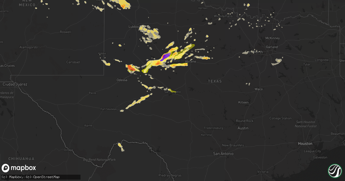
Hail Map on June 5, 2013
Get this storm
June 5 map
$229
one time, instant access
Download today. No call, no setup
Keep the $229
Bought the map and want the full workflow? Apply the entire $229 to a subscription within 7 days. None of it is wasted.
Every map, not just this one
This buys you this map. Subscription and you get every map we run, in the markets you choose from a few cities to whole states to nationwide. Plus real-time alerts the moment a storm fires.
Contact data
Name, contact info, occupancy, even credit band for addresses in the footprint. You go from where it hit to who to call.
Become the source they trust
Unlimited branding weather history reports on demand. You already have the documented answer ready for the property owner, and you are the one who showed up with it.
Property data and RoofTrace estimates
Pull up any address you have got, its value and the exact code rules for that jurisdiction, straight from One Click Code. Then RoofTrace estimates the squares, pitch, and roof value, priced the way you price.
States Impacted by Hail Map on June 5, 2013
Storm reports
Tennessee
| Date | Description |
|---|---|
| 06/05/20135:00 PM CDT | One tree down on upper middle creek rd. |
| 06/05/20133:30 PM CDT | One inch hail in talbott |
| 06/05/20132:00 PM CDT | A few trees down around the chattanooga area. |
| 06/05/20131:45 PM CDT | A few trees down across northen end of county |
Alabama
| Date | Description |
|---|---|
| 06/05/201312:48 PM CDT | A bradford pear tree was knocked down between the 1200 and 1300 block of county road 98 between bridgeport and russell cave national monument. |
| 06/05/201311:38 AM CDT | A tree was blown down on crockett road. |
| 06/05/201311:31 AM CDT | Thunderstorm winds knocked down two trees on mill road and flattened patches of wheat. The maximum wind speeds were estimated to be 60 mph. |
| 06/05/201311:23 AM CDT | A tree down was blown down at court st and irvine ave. |
| 06/05/201310:54 AM CDT | A tree was blown down at lawton ave and midway st. |
| 06/05/20138:26 AM CDT | Power outages were reported along woodward avenue beginning near lowes and continuing northward along woodward avenue into the muscle shoals area. |
| 06/05/20138:16 AM CDT | A tree was blown down on frankfort road nead the entrance to r. E. Thompson elementary school. |
| 06/05/20138:11 AM CDT | Power lines reported down on underwood mountain road. |
Louisiana
| Date | Description |
|---|---|
| 06/05/20136:00 AM CDT | A large tree fell adjacent to the old antoons restaurant on washington street...damaging a corner of the building. A canopy was also blown off a building on south dr. N |
| 06/05/20135:50 AM CDT | Several large pecan trees were blown down at the oakland plantation within the cane river creole national historic park in the bermuda community. |
| 06/05/20135:38 AM CDT | Trees down on 471 and litle horseshoe road |
| 06/05/20135:25 AM CDT | Numerous trees downed near the verda community in extreme northwest grant parish. |
| 06/05/20135:20 AM CDT | Numerous trees down south of atlanta in extreme southwest winn parish. |
| 06/05/20132:20 AM CDT | A local report indicates 1.00 inch wind near ALEXANDRIA |
| 06/05/20132:15 AM CDT | Wind estimated by public of 60 to 70 mph near airport. |
| 06/05/20131:58 AM CDT | Wind measured at aex asos. |
Florida
| Date | Description |
|---|---|
| 06/05/20135:45 AM CDT | *** 1 inj *** homes damaged... Trees and power poles snapped and downed. The path length was 2 miles and the path width was 50 to 100 yards. |
| 06/05/20132:50 AM CDT | Power lines down along sun city blvd. Time estimated by radar. |
| 06/05/20132:50 AM CDT | Small tree limbs down and lawn furniture blown around. Time estimated by radar. |
| 06/05/20132:48 AM CDT | Porch blown down and landed on neighbors house and adjacent road. |
| 06/05/20132:20 AM CDT | Emergency management received reports of funnel cloud on south side of belle glade. Numerous powerlines down throughout the city from possible tornado. |
| 06/05/20132:20 AM CDT | Ef-0 confirmed tornado...minor damage to trees and power lines. |
| 06/05/20131:59 AM CDT | Damage to a house. Pool cage torn down |
| 06/05/20131:53 AM CDT | Building in roadway...possibly a shed. Powerlines down near singletary rd and state rd 70. |
Kansas
| Date | Description |
|---|---|
| 06/05/20131:20 PM CDT | Several 2 to 3 inch tree limbs down. Wind estimated at near 70 mph. The caller also received 0.87 inches of rain. |
| 06/05/20131:07 PM CDT | 3 inch tree limbs down from an old cottonwood tree. Wind estimated at 70 mph. |
Minnesota
| Date | Description |
|---|---|
| 06/05/20135:42 PM CDT | No damage known. Spotter confirmed with pictures. Time estimated via radar. Preliminary ef0 rating. |
North Carolina
| Date | Description |
|---|---|
| 06/05/20135:15 PM CDT | Several trees down across the county. |
Arkansas
| Date | Description |
|---|---|
| 06/05/20136:40 PM CDT | Severe winds downed a powerline...several billboard...and several business signs. Roofs also reported off of warehouse buildings. Powerpoles snapped northwest and south |
| 06/04/20138:05 PM CDT | Funnel clouds descended into a tornado just west of the mississippi river as reported by a trained storm spotter. This tornado moved east onto the mississippi river. Th |
| 06/04/20137:55 PM CDT | Golfball sized hail reported by trained weather spotter. |
| 06/04/20137:50 PM CDT | A large tree down on an automobile in jericho...due to damaging winds. |
| 06/04/20137:50 PM CDT | Quarter size hail in jericho. |
| 06/04/20137:45 PM CDT | Large pivot on irrigation system broken up from high winds near mile marker 17 on interstate 55. |
| 06/04/20137:38 PM CDT | Quarter size hail reported at mile marker 18 along interstate 55 approximately 1 mile north of jericho. |
Texas
| Date | Description |
|---|---|
| 06/05/20136:30 PM CDT | A local report indicates 60 MPH wind near 26 NNE BIG LAKE |
| 06/05/20136:00 PM CDT | A local report indicates 68 MPH wind near 5 SW ST. LAWRENCE |
| 06/05/20136:45 AM CDT | 3-inch tree limbs blown down in the city of terrell |
| 06/05/20131:30 AM CDT | Limbs down along county road 654. Shingles removed from roof. |
| 06/05/20131:21 AM CDT | A local report indicates 61 MPH wind near 3 ESE ABILENE |
| 06/05/201312:40 AM CDT | Trees and power lines reported down in sweetwater. |
| 06/05/201312:27 AM CDT | A local report indicates 1.00 inch wind near WHITE RIVER LAKE |
| 06/05/201312:20 AM CDT | Powerline down on east lee street |
| 06/05/201312:10 AM CDT | A local report indicates 72 MPH wind near 3 E SNYDER |
| 06/05/201312:05 AM CDT | Several 3 inch diameter limbs about 10 feet long blown down on the nw side of breckenridge. |
| 06/05/201312:05 AM CDT | Reported by west texas mesonet |
| 06/05/201312:00 AM CDT | A local report indicates 66 MPH wind near 6 SSW WOLFFORTH |
| 06/05/201312:00 AM CDT | A local report indicates 60 MPH wind near 5 NW SNYDER |
| 06/04/201311:46 PM CDT | A local report indicates 62 MPH wind near MIDLAND INTERNATIONAL A |
| 06/04/201311:45 PM CDT | A local report indicates 64 MPH wind near 1 N O'DONNELL |
| 06/04/201311:43 PM CDT | A local report indicates 62 MPH wind near MIDLAND INTERNATIONAL A |
| 06/04/201311:40 PM CDT | A local report indicates 62 MPH wind near 1 NW LAKE ALAN HENRY |
| 06/04/201311:40 PM CDT | A local report indicates 70 MPH wind near 3 WNW FLUVANNA |
| 06/04/201311:30 PM CDT | Public reported storage shed was destroyed by winds. Estimated time of occurence is 1130 to 1145 pm cdt |
| 06/04/201311:30 PM CDT | Large tree down in albany |
| 06/04/201311:29 PM CDT | A local report indicates 77 MPH wind near 6 NE LUBBOCK |
| 06/04/201311:25 PM CDT | Large oak tree down in moran |
| 06/04/201311:25 PM CDT | A local report indicates 1.75 inch wind near 2 E MORAN |
| 06/04/201311:05 PM CDT | A local report indicates 74 MPH wind near 6 SSW ANTON |
| 06/04/201311:05 PM CDT | From west texas mesonet |
| 06/04/201311:00 PM CDT | A local report indicates 59 MPH wind near 1 ENE MORTON |
| 06/04/201311:00 PM CDT | Roof blown off of barn. |
| 06/04/201311:00 PM CDT | A local report indicates 60 MPH wind near STAMFORD |
| 06/04/201311:00 PM CDT | North side of barn destroyed between 1100-1130 pm cdt. |
| 06/04/201311:00 PM CDT | At the intersection e of slide and marsha sharp without power... Broken tree limbs. At 28th and boston broken windows on e and n sides due to hail... And blown down woo |
| 06/04/201311:00 PM CDT | A local report indicates 58 MPH wind near REESE CENTER |
| 06/04/201311:00 PM CDT | A local report indicates 70 MPH wind near 6 SSW ANTON |
| 06/04/201311:00 PM CDT | A local report indicates 1.00 inch wind near STAMFORD |
| 06/04/201311:00 PM CDT | A local report indicates 62 MPH wind near 3 NNE TAHOKA |
| 06/04/201310:55 PM CDT | A local report indicates 75 MPH wind near 6 SSW ANTON |
| 06/04/201310:50 PM CDT | A local report indicates 1.00 inch wind near STAMFORD |
| 06/04/201310:50 PM CDT | A local report indicates 82 MPH wind near 2 NE SLATON |
| 06/04/201310:50 PM CDT | Five power poles snapped along highway 62. Time estimated. |
| 06/04/201310:45 PM CDT | A local report indicates 62 MPH wind near 2 NNE SEMINOLE |
| 06/04/201310:45 PM CDT | A local report indicates 1.25 inch wind near STAMFORD |
| 06/04/201310:40 PM CDT | A local report indicates 60 MPH wind near 4 N HAWLEY |
| 06/04/201310:40 PM CDT | A local report indicates 60 MPH wind near 6 S OLTON |
| 06/04/201310:40 PM CDT | A local report indicates 67 MPH wind near REESE CENTER |
| 06/04/201310:38 PM CDT | A local report indicates 58 MPH wind near 1 SW SEAGRAVES |
| 06/04/201310:35 PM CDT | Several trees blown down and windows broken across the texas tech university campus. |
| 06/04/201310:35 PM CDT | A local report indicates 68 MPH wind near 1 ENE MORTON |
| 06/04/201310:35 PM CDT | Radio tower blown down onto fire department |
| 06/04/201310:35 PM CDT | A local report indicates 1.00 inch wind near 1 E HAWLEY |
| 06/04/201310:34 PM CDT | A local report indicates 84 MPH wind near 6 SSW WOLFFORTH |
| 06/04/201310:31 PM CDT | A local report indicates 72 MPH wind near 4 SSW LUBBOCK |
| 06/04/201310:31 PM CDT | Visilibility severly restricted. |
| 06/04/201310:30 PM CDT | Several trees blown down...power lines down...and several carports turned over |
| 06/04/201310:30 PM CDT | Roof material was blown off of west side of high school...a few trees were toppled...power lines down...several carports turned over...siding on home was removed...and |
| 06/04/201310:30 PM CDT | Substantial roof damage to apartment complex. |
| 06/04/201310:30 PM CDT | A local report indicates 75 MPH wind near 6 SSW WOLFFORTH |
| 06/04/201310:20 PM CDT | A local report indicates 1.50 inch wind near FRANKEL CITY |
| 06/04/201310:15 PM CDT | A local report indicates 63 MPH wind near 1 ENE MORTON |
| 06/04/201310:15 PM CDT | A local report indicates 81 MPH wind near REESE CENTER |
| 06/04/201310:15 PM CDT | A local report indicates 60 MPH wind near 7 WNW DENVER CITY |
| 06/04/201310:11 PM CDT | Poor visibility |
| 06/04/201310:10 PM CDT | Window screens were shredded. Time estimated by radar |
| 06/04/201310:10 PM CDT | A local report indicates 1.75 inch wind near ROTAN |
| 06/04/201310:07 PM CDT | A local report indicates 1.00 inch wind near ROTAN |
| 06/04/201310:07 PM CDT | A local report indicates 75 MPH wind near ROTAN |
| 06/04/201310:05 PM CDT | A local report indicates 65 MPH wind near 1 ENE MORTON |
| 06/04/201310:05 PM CDT | A local report indicates 69 MPH wind near 3 N PLAINS |
| 06/04/201310:05 PM CDT | A local report indicates 68 MPH wind near 6 SSW ANTON |
| 06/04/201310:05 PM CDT | A local report indicates 66 MPH wind near 4 S LEVELLAND |
| 06/04/201310:00 PM CDT | A local report indicates 1.75 inch wind near 4 S ROBY |
| 06/04/201310:00 PM CDT | A local report indicates 1.75 inch wind near 3 N ROBY |
| 06/04/201310:00 PM CDT | A local report indicates 76 MPH wind near 4 S LEVELLAND |
| 06/04/201310:00 PM CDT | A local report indicates 67 MPH wind near 6 SSW ANTON |
| 06/04/20139:55 PM CDT | A local report indicates 1.75 inch wind near 1 S ROBY |
| 06/04/20139:50 PM CDT | A local report indicates 67 MPH wind near 3 N PLAINS |
| 06/04/20139:45 PM CDT | A local report indicates 60 MPH wind near 2 SSW MULESHOE |
| 06/04/20139:40 PM CDT | Roof barn was blown off on county road 351 |
| 06/04/20139:33 PM CDT | Several 8 inch diameter by 10-12 feet long limbs down. |
| 06/04/20139:30 PM CDT | A local report indicates 72 MPH wind near 1 ENE MORTON |
| 06/04/20139:30 PM CDT | Public reported storage shed was destroyed by winds. Estimated time of occurence is 2130 to 2145 cdt |
| 06/04/20139:27 PM CDT | Report from social media |
| 06/04/20139:22 PM CDT | A local report indicates 2.00 inch wind near 3 W SPRINGLAKE |
| 06/04/20139:20 PM CDT | A local report indicates 1.00 inch wind near COLORADO CITY |
| 06/04/20139:10 PM CDT | Car port and small trailer house sustained significant damage on the morrow ranch |
| 06/04/20139:04 PM CDT | Golf ball size hail on highway 70 |
| 06/04/20138:54 PM CDT | Winshield was shattered. |
| 06/04/20138:49 PM CDT | Limbs being ripped from trees with penny sized hail. |
| 06/04/20138:45 PM CDT | A local report indicates 70 MPH wind near WESTBROOK |
| 06/04/20138:45 PM CDT | Police cruiser had windshield busted out due to the hail. |
| 06/04/20138:45 PM CDT | Utility pole down in rowena |
| 06/04/20138:45 PM CDT | Hail between golf ball and egg size |
| 06/04/20138:34 PM CDT | A local report indicates 1.75 inch wind near FRIONA |
| 06/04/20138:30 PM CDT | A local report indicates 63 MPH wind near 2 NE FRIONA |
| 06/04/20138:30 PM CDT | A local report indicates 1.00 inch wind near TARZAN |
| 06/04/20138:28 PM CDT | A local report indicates 1.75 inch wind near FRIONA |
| 06/04/20138:27 PM CDT | A local report indicates 1.00 inch wind near LEES |
| 06/04/20138:25 PM CDT | 1.2 inches of rain in 30 minutes measured |
| 06/04/20138:15 PM CDT | A local report indicates 60 MPH wind near 2 NE FRIONA |
| 06/04/20138:07 PM CDT | Golf ball sized hail is covering the ground |
| 06/04/20138:07 PM CDT | Golf ball sized hail is covering the ground |
| 06/04/20138:01 PM CDT | A local report indicates 1.75 inch wind near TARZAN |
| 06/04/20138:00 PM CDT | Hail occurred between 800-830 pm cdt. |
| 06/04/20138:00 PM CDT | Quarter size hail reported near pierce and beauregard |
| 06/04/20138:00 PM CDT | 30 foot tree down on louise drive |
| 06/04/20137:50 PM CDT | A local report indicates 59 MPH wind near 7 N BOOTLEG |
| 06/04/20137:38 PM CDT | 6 miles north of intersection of arden road and fm 2288 |
| 06/04/20137:38 PM CDT | 6 miles north of intersection of arden road and fm 2288 |
New Mexico
| Date | Description |
|---|---|
| 06/05/20136:40 PM CDT | A local report indicates 1.75 inch wind near 9 SSE LOGAN |
| 06/05/20136:25 PM CDT | A local report indicates 1.75 inch wind near 6 NNE LOGAN |
| 06/05/20133:00 PM CDT | A local report indicates 1.00 inch wind near 1 SE ROCIADA |
| 06/05/20132:30 PM CDT | A local report indicates 1.00 inch wind near 2 ESE OCATE |
| 06/04/201310:17 PM CDT | A local report indicates 59 MPH wind near 5 NW HOBBS |
| 06/04/201310:12 PM CDT | Brown-out conditions...snapped power poles...trees down...and estimated wind gust of 60 mph |
| 06/04/20139:50 PM CDT | A local report indicates 62 MPH wind near 2 SW TATUM |
| 06/04/20139:35 PM CDT | A local report indicates 62 MPH wind near 2 SW TATUM |
| 06/04/20139:35 PM CDT | A local report indicates 62 MPH wind near TATUM |
| 06/04/20138:55 PM CDT | Kcvn awos. |
| 06/04/20138:45 PM CDT | A local report indicates 64 MPH wind near 2 SW DORA |
| 06/04/20138:38 PM CDT | 4 inch diameter tree limbs broken. |
| 06/04/20138:37 PM CDT | Eight mile draw raws. |
| 06/04/20138:32 PM CDT | A local report indicates 70 MPH wind near TEXICO |
| 06/04/20138:23 PM CDT | A local report indicates 69 MPH wind near 4 SW FLOYD |
| 06/04/20138:20 PM CDT | Kcvs asos. |
| 06/04/20138:16 PM CDT | A local report indicates 66 MPH wind near 5 N CANNON AFB |
| 06/04/20137:25 PM CDT | A local report indicates 66 MPH wind near 1 E FORT SUMNER |
| 06/04/20137:02 PM CDT | A local report indicates 60 MPH wind near 4 NNW BARD |
| 06/04/20137:02 PM CDT | A local report indicates 1.50 inch wind near 4 NNW BARD |
Georgia
| Date | Description |
|---|---|
| 06/05/20136:05 PM CDT | A tree fell on a truck off gaston street. Trees across powerlines off newport street in nw atlanta. |
Mississippi
| Date | Description |
|---|---|
| 06/05/20136:40 PM CDT | Trees down along trace road near springhill road. |
| 06/05/20136:00 PM CDT | A few trees down on pine springs road and north hills street |
| 06/05/20133:14 PM CDT | Penny to quarter size hail fell in the area |
| 06/05/20132:57 PM CDT | Reports of a tree down on the natchez trace parkway between french camp and stewart weir road. |
| 06/05/20132:13 PM CDT | A few trees down along with numerous 3-4 inch diameter limbs down in downtown tupelo. |
| 06/05/20132:00 PM CDT | Several trees have fallen on homes and across roads. |
| 06/05/20131:42 PM CDT | Several trees were down on homes and across roads. |
| 06/05/20131:40 PM CDT | A local report indicates 1.00 inch wind near LELAND |
| 06/05/20131:05 PM CDT | Reports of tree down at wilcox road and redman road and also on tampa drive. |
| 06/04/201311:40 PM CDT | Reports of a tree down on kings point road. |
| 06/04/20138:15 PM CDT | Perry county ema reports a large tree down in the community of richton. |
| 06/04/20137:45 PM CDT | Several trees down in the southern and eastern portions of the county. Minor flooding occurred as well. |
| 06/04/20137:05 PM CDT | Couple trees blown down in town |
Cities Impacted by Hail Map on June 5, 2013
- Encino, NM
- Sweetwater, TX
- Trent, TX
- Merkel, TX
- Rule, TX
- Amory, MS
- Smithville, MS
- Charleston, MS
- Tutwiler, MS
- Vaughn, NM
- Conchas Dam, NM
- Mosquero, NM
- Hollandale, MS
- Atlanta, GA
- Andrews, TX
- Friona, TX
- Broadview, NM
- Texico, NM
- Garden City, TX
- Baldwyn, MS
- Muleshoe, TX
- Albany, TX
- Courtland, MS
- Batesville, MS
- Aberdeen, MS
- Ringling, OK
- Healdton, OK
- Dubach, LA
- Sterling City, TX
- Big Lake, TX
- Tarzan, TX
- Stanton, TX
- Stanley, NM
- Rotan, TX
- Aspermont, TX
- Jayton, TX
- Abilene, TX
- Stamford, TX
- Big Spring, TX
- Coahoma, TX
- West Memphis, AR
- Earle, AR
- Crawfordsville, AR
- Turrell, AR
- Marion, AR
- Hermleigh, TX
- Heflin, LA
- McCaulley, TX
- Hamlin, TX
- Roby, TX
- Roy, NM
- Moran, TX
- Fort Stockton, TX
- Valley Mills, TX
- Springlake, TX
- Earth, TX
- Tyronza, AR
- Grady, NM
- Holly Springs, MS
- Waterford, MS
- West Monroe, LA
- Calhoun, LA
- Eros, LA
- Bard, NM
- Nauvoo, AL
- Lynn, AL
- Justiceburg, TX
- Post, TX
- Hampton, AR
- Camden, AR
- Portales, NM
- Oakland, MS
- Cisco, TX
- Midkiff, TX
- Ozona, TX
- Raton, NM
- Olton, TX
- Newellton, LA
- Corona, NM
- Tiptonville, TN
- Union City, TN
- Jonesboro, AR
- Oneonta, AL
- Blountsville, AL
- Altoona, AL
- Colorado City, TX
- Westbrook, TX
- Gleason, TN
- Dresden, TN
- Manchester, TN
- Winnsboro, LA
- Des Moines, NM
- Alexandria, LA
- Santa Fe, NM
- Rochester, TX
- Spur, TX
- Sardis, MS
- O'Brien, TX
- Saline, LA
- Ashland, LA
- Castor, LA
- Farwell, TX
- Logan, NM
- San Jon, NM
- Dimmitt, TX
- Tucumcari, NM
- Plainview, TX
- Hart, TX
- Hereford, TX
- Hale Center, TX
- Bovina, TX
- Fieldton, TX
- Saint Jo, TX
- Knox City, TX
- Munday, TX
- Cascilla, MS
- Haleyville, AL
- Double Springs, AL
- Fisher, AR
- Cherry Valley, AR
- Weiner, AR
- Harrisburg, AR
- Anson, TX
- Sylvester, TX
- Willard, NM
- Coushatta, LA
- Denison, TX
- Solano, NM
- Hawley, TX
- Clovis, NM
- Grenada, MS
- Duck Hill, MS
- McCarley, MS
- Ryan, OK
- Loop, TX
- Brownfield, TX
- Pell City, AL
- Odenville, AL
- Ruston, LA
- Kaufman, TX
- Roscoe, TX
- Fluvanna, TX
- Natchitoches, LA
- Cherokee, AL
- Avoca, TX
- Ragland, AL
- Scurry, TX
- Loraine, TX
- Maryneal, TX
- Haltom City, TX
- Fort Worth, TX
- Weinert, TX
- Coffeeville, MS
- Haskell, TX
- Ira, TX
- Las Vegas, NM
- Sapello, NM
- Naval Air Station Jrb, TX
- Taiban, NM
- Hamilton, AL
- Detroit, AL
- Nolan, TX
- Crosbyton, TX
- Athens, TN
- Riceville, TN
- Winnfield, LA
- Talbott, TN
- Jefferson City, TN
- Potts Camp, MS
- Ocate, NM
- Enid, MS
- Lambert, MS
- Gobler, MO
- Steele, MO
- Readyville, TN
- Woodbury, TN
- Christiana, TN
- Bradyville, TN
- Beechgrove, TN
- Tuscumbia, AL
- Atlanta, LA
- Booneville, MS
- Eunice, NM
- Menlo, GA
- Throckmorton, TX
- Normandy, TN
- Wartrace, TN
- Tullahoma, TN
- Amherst, TX
- Sudan, TX
- Ringgold, LA
- Gainesville, TX
- Memphis, TN
- Tupelo, MS
- Newport, AR
- Tuckerman, AR
- West Point, MS
- Prairie, MS
- Breckenridge, TX
- Whitesboro, TX
- Stuttgart, AR
- Slaton, TX
- Denver City, TX
- Ralls, TX
- Mertzon, TX
- Columbia, LA
- Muenster, TX
- Forestburg, TX
- Farmerville, LA
- Sterlington, LA
- Bastrop, LA
- Monroe, LA
- Collinston, LA
- Fayette, AL
- Snyder, TX
- Amagon, AR
- Cash, AR
- Natchez, LA
- Cosby, TN
- Florien, LA
- Lindsay, TX
- Prattville, AL
- Magee, MS
- Colfax, LA
- Montgomery, LA
- Quitman, LA
- Water Valley, MS
- Midland, TX
- Trementina, NM
- Savoy, TX
- Nettleton, MS
- Florence, AL
- Mathiston, MS
- Eupora, MS
- Mer Rouge, LA
- Marietta, MS
- Sunflower, MS
- Doddsville, MS
- Wichita Falls, TX
- Holliday, TX
- Olla, LA
- Moriarty, NM
- Petrolia, TX
- Tchula, MS
- Belzoni, MS
- Henrietta, TX
- Lorenzo, TX
- Ransom Canyon, TX
- San Angelo, TX
- Nocona, TX
- Fort Sumner, NM
- Rolling Fork, MS
- Oak Ridge, LA
- Piedmont, AL
- Leesburg, AL
- Gadsden, AL
- Centre, AL
- Lake Providence, LA
- Lake Village, AR
- Eudora, AR
- Tremont, MS
- Greenwood Springs, MS
- Birmingham, AL
- Arlington, TX
- Byhalia, MS
- Tillatoba, MS
- Sherman, TX
- Van Alstyne, TX
- Whitewright, TX
- Heflin, AL
- Steens, MS
- Horton, AL
- Guntersville, AL
- Russellville, AL
- Bellevue, TX
- Chatham, LA
- Sikes, LA
- Grayson, LA
- Geraldine, AL
- Rociada, NM
- Madisonville, TN
- Sweetwater, TN
- Kingston, OK
- Monett, MO
- Sevierville, TN
- Cedarbluff, MS
- Pheba, MS
- Hickman, KY
- Troy, TN
- Summerville, GA
- Pinson, AL
- Trussville, AL
- Jasper, AL
- Tahoka, TX
- Thackerville, OK
- Blackwell, TX
- Seagraves, TX
- Aledo, TX
- Weatherford, TX
- Carlsbad, TX
- Ackerman, MS
- Kemp, TX
- Ennis, TX
- Rosser, TX
- Etowah, TN
- Humphrey, AR
- Pontotoc, MS
- Red Banks, MS
- Lamar, MS
- Lewisburg, TN
- Shelbyville, TN
- Iraan, TX
- Winona, MS
- Bell Buckle, TN
- Woodson, TX
- Elm Grove, LA
- Dubberly, LA
- Jamestown, LA
- Sibley, LA
- Gladstone, NM
- Leland, MS
- Vicksburg, MS
- Guadalupita, NM
- Seymour, TX
- Pecos, NM
- Greenville, MS
- Moody, AL
- Bells, TX
- Lexington, MS
- Pope, MS
- Aliceville, AL
- Brookland, AR
- Bono, AR
- Wentworth, MO
- Estill Springs, TN
- Winchester, TN
- Sadler, TX
- Pottsboro, TX
- Clifton, TX
- Crenshaw, MS
- Delhi, LA
- Hazen, AR
- Jonesboro, LA
- Dodson, LA
- Bearden, AR
- Bienville, LA
- Iowa Park, TX
- Mead, OK
- Lubbock, TX
- Delta, AL
- Shannon, MS
- Talladega, AL
- Maryville, TN
- Vernon, TX
- Jones, LA
- Ringgold, TX
- Pineville, LA
- Ashland, AL
- Okolona, MS
- Houlka, MS
- Shaw, MS
- Signal Mountain, TN
- Star City, AR
- Monticello, KY
- Cimarron, NM
- Bonham, TX
- Tye, TX
- Yazoo City, MS
- Hamburg, AR
- Campti, LA
- Thorn Hill, TN
- Plantersville, MS
- Verona, MS
- Fackler, AL
- Stevenson, AL
- Bridgeport, AL
- Prentiss, MS
- Mount Olive, MS
- Santa Rosa, NM
- Vina, AL
- Red Bay, AL
- Pine Bluff, AR
- Montezuma, NM
- Rockford, TN
- Jasper, TN
- Sequatchie, TN
- Whitwell, TN
- Gaylesville, AL
- Mentone, AL
- Quitman, MS
- Jena, LA
- Gilmore, AR
- Lueders, TX