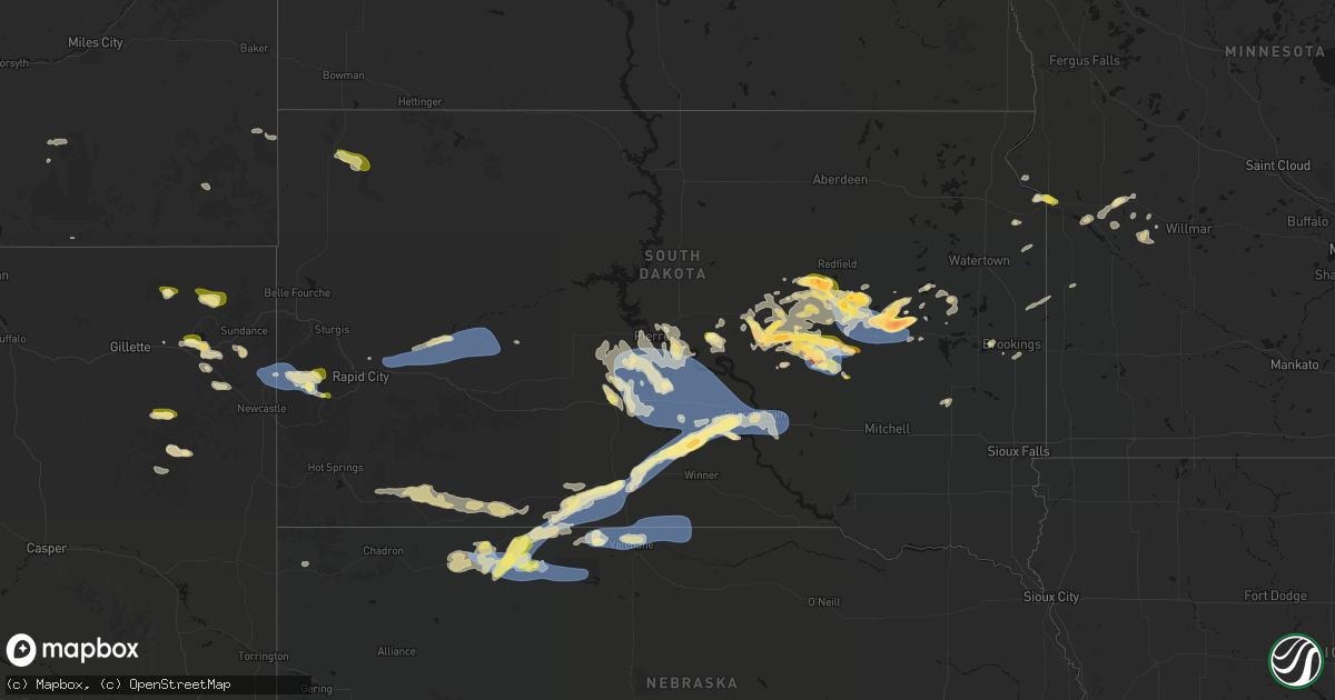
Hail Map in South Dakota on June 4, 2026
Get this storm
June 4 map
$229
one time, instant access
Download today. No call, no setup
Keep the $229
Bought the map and want the full workflow? Apply the entire $229 to a subscription within 7 days. None of it is wasted.
Every map, not just this one
This buys you this map. Subscription and you get every map we run, in the markets you choose from a few cities to whole states to nationwide. Plus real-time alerts the moment a storm fires.
Contact data
Name, contact info, occupancy, even credit band for addresses in the footprint. You go from where it hit to who to call.
Become the source they trust
Unlimited branding weather history reports on demand. You already have the documented answer ready for the property owner, and you are the one who showed up with it.
Property data and RoofTrace estimates
Pull up any address you have got, its value and the exact code rules for that jurisdiction, straight from One Click Code. Then RoofTrace estimates the squares, pitch, and roof value, priced the way you price.
Storm reports in South Dakota
South Dakota
| Date | Description |
|---|---|
| 06/04/20266:59 PM CDT | A local report indicates 1.00 inch wind near 1 E Hill City |
| 06/04/20266:52 PM CDT | Report from mping: ping pong ball |
| 06/04/20266:50 PM CDT | A local report indicates 1.75 inch wind near 9 SE Tulare |
| 06/04/20266:28 PM CDT | Time estimated. |
| 06/04/20266:26 PM CDT | A local report indicates 1.00 inch wind near 3 SE Deerfield |
| 06/04/20266:25 PM CDT | Sent via social media picture. |
| 06/04/20262:50 PM CDT | A local report indicates 1.50 inch wind near 5 WSW Bancroft |
| 06/04/20262:47 PM CDT | A local report indicates 1.50 inch wind near 6 WSW Bancroft |
| 06/04/20262:39 PM CDT | Various hail size from golf ball to baseball via photo. |
| 06/04/20262:31 PM CDT | A local report indicates 2.00 inch wind near Yale |
| 06/03/202611:28 PM CDT | A local report indicates 62 MPH wind near 3 S Chamberlain |
| 06/03/202611:24 PM CDT | Mesonet station 54 reliance |
| 06/03/202611:05 PM CDT | Mesonet station 285 lower brule 14 w |
| 06/03/202610:45 PM CDT | Mesonet station vvms2 vivian 12s |
| 06/03/202610:36 PM CDT | Mesonet station 13 vivian |
| 06/03/202610:31 PM CDT | Mesonet station 13 vivian |
| 06/03/202610:15 PM CDT | Estimated 50mph wind gusts associated with numerous hailstones. |
| 06/03/202610:07 PM CDT | Report from mping: quarter |
| 06/03/20269:55 PM CDT | A local report indicates 72 MPH wind near 7 ESE Rosebud |
| 06/03/20269:53 PM CDT | Measured on private weather station. |
| 06/03/20269:31 PM CDT | Em report of quarter sized hail just north of lane... Sd. Timing confirmed with radar. |
| 06/03/20268:34 PM CDT | Mesonet station rhus2 danforth 5 e. Time estimated by radar. |
| 06/03/20268:00 PM CDT | A local report indicates 60 MPH wind near 2 E Elm Springs |
| 06/03/20267:55 PM CDT | A local report indicates 62 MPH wind near 2 E Elm Springs |
| 06/03/20267:51 PM CDT | A local report indicates 61 MPH wind near 3 NW Wasta |
| 06/03/20267:39 PM CDT | A local report indicates 1.00 inch wind near 10 S Wessington |
| 06/03/20267:33 PM CDT | Asos station khon huron regional airport. |
| 06/03/20267:31 PM CDT | Report from mping: quarter |
| 06/03/20267:27 PM CDT | Time estimated. Also came with brief 50 to 60 mph gusts. |
| 06/03/20267:04 PM CDT | Mesonet station 164 sd rwis wolsey. |
All States Impacted by Hail Map on June 4, 2026
Cities Impacted by Hail Map on June 4, 2026
- Lake Arthur, NM
- Haddam, KS
- Morrowville, KS
- Mahaska, KS
- Lakeview, TX
- Washington, KS
- Wichita, KS
- Kechi, KS
- Wolsey, SD
- Burchard, NE
- Clarendon, TX
- Shamrock, TX
- Mclean, TX
- Solomon, KS
- Minneapolis, KS
- Manhattan, KS
- Olsburg, KS
- Seneca, KS
- Wheeler, TX
- Huron, SD
- Du Bois, NE
- Humboldt, NE
- Bryant, SD
- Lahoma, OK
- Helena, OK
- Yale, SD
- Cavour, SD
- Iroquois, SD
- Willow Lake, SD
- Canova, SD
- Mayfield, KS
- Argonia, KS
- Milan, KS
- Conway Springs, KS
- Wellington, KS
- Dawson, NE
- Forsyth, MT
- Carpenter, SD
- Erwin, SD
- Clearwater, KS
- Stella, NE
- Peck, KS
- Haysville, KS
- Lame Deer, MT
- Verdon, NE
- Council Grove, KS
- Mulvane, KS
- Belle Plaine, KS
- Ashland, MT
- Derby, KS
- Mcconnell Afb, KS
- Rose Hill, KS
- Andover, KS
- South Haven, KS
- Fort Stockton, TX
- Otter, MT
- Lake Preston, SD
- De Smet, SD
- Weston, WY
- Hulett, WY
- Moorcroft, WY
- Revillo, SD
- Strandburg, SD
- Labolt, SD
- Saint Marys, KS
- Delia, KS
- Havensville, KS
- Onaga, KS
- Soldier, KS
- Emmett, KS
- Picacho, NM
- Madison, MN
- Appleton, MN
- Stockholm, SD
- Twin Brooks, SD
- Brookings, SD
- Tinnie, NM
- Ekalaka, MT
- Clay Center, KS
- Green, KS
- Danvers, MN
- Volga, SD
- Toronto, SD
- Astoria, SD
- Devils Tower, WY
- Hope, KS
- Holloway, MN
- Benson, MN
- Van Horn, TX
- Brandt, SD
- Canby, MN
- Longford, KS
- Sundance, WY
- Milan, MN
- Porter, MN
- Salt Flat, TX
- Barnes, KS
- Randolph, KS
- Greenleaf, KS
- Waterville, KS
- Blue Rapids, KS
- Marysville, KS
- Bremen, KS
- Hanover, KS
- Upton, WY
- Wakefield, KS
- Gillette, WY
- Rozet, WY
- Oacoma, SD
- Frankfort, KS
- Home, KS
- Maynard, MN
- Montevideo, MN
- Murdock, MN
- Leonardville, KS
- Riley, KS
- Chamberlain, SD
- Horton, KS
- Clara City, MN
- Mule Creek, NM
- Kerkhoven, MN
- Highland, KS
- Troy, KS
- Buffalo, SD
- Reva, SD
- Miller, SD
- Tulare, SD
- Redfield, SD
- Rockham, SD
- Oregon, MO
- Sidney, NE
- Boyes, MT
- Newcastle, WY
- Hill City, SD
- Lead, SD
- Savannah, MO
- Amazonia, MO
- Ree Heights, SD
- Lodgepole, NE
- Dalton, NE
- Mason, TX
- Hitchcock, SD
- Oneida, KS
- Saint Lawrence, SD
- Harrison, NE
- Rea, MO
- Rosendale, MO
- Union Star, MO
- King City, MO
- Wessington, SD
- Hamill, SD
- Rapid City, SD
- Frankfort, SD
- Orient, SD
- McFall, MO
- Albany, MO
- Gregory, SD
- Piedmont, SD
- Virgil, SD
- Fluvanna, TX
- Vienna, SD
- Post, TX
- Douglas, WY
- Darlington, MO
- Saint George, KS
- New Underwood, SD
- Wamego, KS
- Justiceburg, TX
- Box Elder, SD
- Owanka, SD
- Wasta, SD
- Wall, SD
- Merriman, NE
- Alpena, SD
- Outing, MN
- Remer, MN
- Belvue, KS
- Philip, SD
- Milesville, SD
- Clinton, MN
- Rushville, NE
- Gordon, NE
- Mayetta, KS
- Santa Rosa, NM
- Wessington Springs, SD
- Big Stone City, SD
- Ortonville, MN
- Beardsley, MN
- Corona, SD
- Holton, KS
- Tuthill, SD
- Odessa, MN
- Gann Valley, SD
- Saint Francis, SD
- Martin, SD
- Cody, NE
- Highmore, SD
- Rosebud, SD
- Fort Pierre, SD
- Woonsocket, SD
- Hackensack, MN
- Walker, MN
- Murdo, SD
- Okaton, SD
- Circleville, KS
- Mission, SD
- Centralia, KS
- Parmelee, SD
- Pierre, SD
- Valentine, NE
- Draper, SD
- Wetmore, KS
- Wood, SD
- Kilgore, NE
- Nenzel, NE
- Longville, MN
- Crookston, NE
- Vivian, SD
- Winner, SD
- Harrold, SD
- Netawaka, KS
- Corning, KS
- Muleshoe, TX
- Ideal, SD
- Witten, SD
- Presho, SD
- Pine Ridge, SD
- Goff, KS
- Holabird, SD
- Bern, KS
- Whiting, KS
- Kennebec, SD
- Wounded Knee, SD
- Manderson, SD
- Reliance, SD
- Porcupine, SD
- Batesland, SD
- Sabetha, KS
- Pukwana, SD
- Baileyville, KS
- Platte, SD
- Kimball, SD
- Floodwood, MN
- Salem, NE
- Morrill, KS
- White River, SD
- Lower Brule, SD
- Okreek, SD
- Sparks, NE
- Helena, MO
- Amity, MO
- Springview, NE
- Cosby, MO


