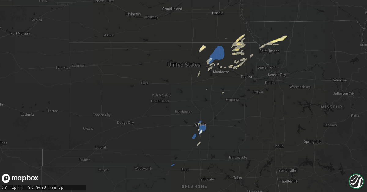
Hail Map in Kansas on June 4, 2026
Get this storm
June 4 map
$229
one time, instant access
Download today. No call, no setup
Keep the $229
Bought the map and want the full workflow? Apply the entire $229 to a subscription within 7 days. None of it is wasted.
Every map, not just this one
This buys you this map. Subscription and you get every map we run, in the markets you choose from a few cities to whole states to nationwide. Plus real-time alerts the moment a storm fires.
Contact data
Name, contact info, occupancy, even credit band for addresses in the footprint. You go from where it hit to who to call.
Become the source they trust
Unlimited branding weather history reports on demand. You already have the documented answer ready for the property owner, and you are the one who showed up with it.
Property data and RoofTrace estimates
Pull up any address you have got, its value and the exact code rules for that jurisdiction, straight from One Click Code. Then RoofTrace estimates the squares, pitch, and roof value, priced the way you price.
Storm reports in Kansas
Kansas
| Date | Description |
|---|---|
| 06/04/20264:57 PM CDT | Report of wind damage to homestead. Em was going to check out damage. |
| 06/04/20263:55 PM CDT | Tree limb down on power line causing down line. |
| 06/04/20263:12 PM CDT | Gusts estimated 50 to 60 mph. |
| 06/04/20262:59 PM CDT | Report from facebook. Time estimated based on radar. |
| 06/04/20262:59 PM CDT | Several large tree limbs down at 1016 e 140th ave in mulvane. |
| 06/04/20262:59 PM CDT | Corrects previous tstm wnd dmg report from 4 wsw mulvane. Several large tree limbs down near 140th ave and hydraulic in mulvane. |
| 06/04/20261:44 PM CDT | Storm chaser report on spotter network and on x with a picture and short video. Mainly over southwest portion of waconda lake. No damage reported. |
| 06/04/20261:05 PM CDT | 50 to 60 mph gusts. |
| 06/04/202612:46 PM CDT | Power poles down with lines down across i-235. I-235 closed both directions. 7000+ customers without power. Time estimated based on radar. Report from broadcast media a |
All States Impacted by Hail Map on June 4, 2026
Cities Impacted by Hail Map on June 4, 2026
- Lake Arthur, NM
- Haddam, KS
- Morrowville, KS
- Mahaska, KS
- Lakeview, TX
- Washington, KS
- Wichita, KS
- Kechi, KS
- Wolsey, SD
- Burchard, NE
- Clarendon, TX
- Shamrock, TX
- Mclean, TX
- Solomon, KS
- Minneapolis, KS
- Manhattan, KS
- Olsburg, KS
- Seneca, KS
- Wheeler, TX
- Huron, SD
- Du Bois, NE
- Humboldt, NE
- Bryant, SD
- Lahoma, OK
- Helena, OK
- Yale, SD
- Cavour, SD
- Iroquois, SD
- Willow Lake, SD
- Canova, SD
- Mayfield, KS
- Argonia, KS
- Milan, KS
- Conway Springs, KS
- Wellington, KS
- Dawson, NE
- Forsyth, MT
- Carpenter, SD
- Erwin, SD
- Clearwater, KS
- Stella, NE
- Peck, KS
- Haysville, KS
- Lame Deer, MT
- Verdon, NE
- Council Grove, KS
- Mulvane, KS
- Belle Plaine, KS
- Ashland, MT
- Derby, KS
- Mcconnell Afb, KS
- Rose Hill, KS
- Andover, KS
- South Haven, KS
- Fort Stockton, TX
- Otter, MT
- Lake Preston, SD
- De Smet, SD
- Weston, WY
- Hulett, WY
- Moorcroft, WY
- Revillo, SD
- Strandburg, SD
- Labolt, SD
- Saint Marys, KS
- Delia, KS
- Havensville, KS
- Onaga, KS
- Soldier, KS
- Emmett, KS
- Picacho, NM
- Madison, MN
- Appleton, MN
- Stockholm, SD
- Twin Brooks, SD
- Brookings, SD
- Tinnie, NM
- Ekalaka, MT
- Clay Center, KS
- Green, KS
- Danvers, MN
- Volga, SD
- Toronto, SD
- Astoria, SD
- Devils Tower, WY
- Hope, KS
- Holloway, MN
- Benson, MN
- Van Horn, TX
- Brandt, SD
- Canby, MN
- Longford, KS
- Sundance, WY
- Milan, MN
- Porter, MN
- Salt Flat, TX
- Barnes, KS
- Randolph, KS
- Greenleaf, KS
- Waterville, KS
- Blue Rapids, KS
- Marysville, KS
- Bremen, KS
- Hanover, KS
- Upton, WY
- Wakefield, KS
- Gillette, WY
- Rozet, WY
- Oacoma, SD
- Frankfort, KS
- Home, KS
- Maynard, MN
- Montevideo, MN
- Murdock, MN
- Leonardville, KS
- Riley, KS
- Chamberlain, SD
- Horton, KS
- Clara City, MN
- Mule Creek, NM
- Kerkhoven, MN
- Highland, KS
- Troy, KS
- Buffalo, SD
- Reva, SD
- Miller, SD
- Tulare, SD
- Redfield, SD
- Rockham, SD
- Oregon, MO
- Sidney, NE
- Boyes, MT
- Newcastle, WY
- Hill City, SD
- Lead, SD
- Savannah, MO
- Amazonia, MO
- Ree Heights, SD
- Lodgepole, NE
- Dalton, NE
- Mason, TX
- Hitchcock, SD
- Oneida, KS
- Saint Lawrence, SD
- Harrison, NE
- Rea, MO
- Rosendale, MO
- Union Star, MO
- King City, MO
- Wessington, SD
- Hamill, SD
- Rapid City, SD
- Frankfort, SD
- Orient, SD
- McFall, MO
- Albany, MO
- Gregory, SD
- Piedmont, SD
- Virgil, SD
- Fluvanna, TX
- Vienna, SD
- Post, TX
- Douglas, WY
- Darlington, MO
- Saint George, KS
- New Underwood, SD
- Wamego, KS
- Justiceburg, TX
- Box Elder, SD
- Owanka, SD
- Wasta, SD
- Wall, SD
- Merriman, NE
- Alpena, SD
- Outing, MN
- Remer, MN
- Belvue, KS
- Philip, SD
- Milesville, SD
- Clinton, MN
- Rushville, NE
- Gordon, NE
- Mayetta, KS
- Santa Rosa, NM
- Wessington Springs, SD
- Big Stone City, SD
- Ortonville, MN
- Beardsley, MN
- Corona, SD
- Holton, KS
- Tuthill, SD
- Odessa, MN
- Gann Valley, SD
- Saint Francis, SD
- Martin, SD
- Cody, NE
- Highmore, SD
- Rosebud, SD
- Fort Pierre, SD
- Woonsocket, SD
- Hackensack, MN
- Walker, MN
- Murdo, SD
- Okaton, SD
- Circleville, KS
- Mission, SD
- Centralia, KS
- Parmelee, SD
- Pierre, SD
- Valentine, NE
- Draper, SD
- Wetmore, KS
- Wood, SD
- Kilgore, NE
- Nenzel, NE
- Longville, MN
- Crookston, NE
- Vivian, SD
- Winner, SD
- Harrold, SD
- Netawaka, KS
- Corning, KS
- Muleshoe, TX
- Ideal, SD
- Witten, SD
- Presho, SD
- Pine Ridge, SD
- Goff, KS
- Holabird, SD
- Bern, KS
- Whiting, KS
- Kennebec, SD
- Wounded Knee, SD
- Manderson, SD
- Reliance, SD
- Porcupine, SD
- Batesland, SD
- Sabetha, KS
- Pukwana, SD
- Baileyville, KS
- Platte, SD
- Kimball, SD
- Floodwood, MN
- Salem, NE
- Morrill, KS
- White River, SD
- Lower Brule, SD
- Okreek, SD
- Sparks, NE
- Helena, MO
- Amity, MO
- Springview, NE
- Cosby, MO


