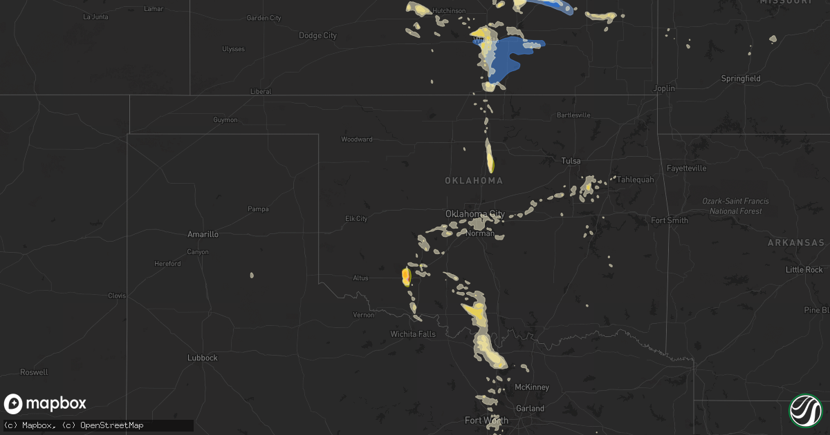
Hail Map in Oklahoma on June 4, 2024
Get this storm
June 4 map
$229
one time, instant access
Download today. No call, no setup
Keep the $229
Bought the map and want the full workflow? Apply the entire $229 to a subscription within 7 days. None of it is wasted.
Every map, not just this one
This buys you this map. Subscription and you get every map we run, in the markets you choose from a few cities to whole states to nationwide. Plus real-time alerts the moment a storm fires.
Contact data
Name, contact info, occupancy, even credit band for addresses in the footprint. You go from where it hit to who to call.
Become the source they trust
Unlimited branding weather history reports on demand. You already have the documented answer ready for the property owner, and you are the one who showed up with it.
Property data and RoofTrace estimates
Pull up any address you have got, its value and the exact code rules for that jurisdiction, straight from One Click Code. Then RoofTrace estimates the squares, pitch, and roof value, priced the way you price.
Storm reports in Oklahoma
Oklahoma
| Date | Description |
|---|---|
| 06/04/202412:25 AM CDT | A local report indicates 59 MPH wind near 3 NNE Sparks |
| 06/04/202412:15 AM CDT | Tree fell on house. |
| 06/03/202411:50 PM CDT | Spotter measured winds at hwy 69 and the arkansas river. |
| 06/03/202411:42 PM CDT | Nickel size hail also falling at location; hwy 69 and muskogee tpke junction. |
| 06/03/202411:15 PM CDT | A local report indicates 58 MPH wind near 1 N Ringling |
| 06/03/202411:15 PM CDT | A local report indicates 60 MPH wind near 7 NNW Velma |
| 06/03/202410:30 PM CDT | A local report indicates 2.75 inch wind near Cache |
| 06/03/202410:25 PM CDT | Several reports of downed power lines and power outages. |
| 06/03/202410:13 PM CDT | Report from mping: half dollar |
| 06/03/20249:34 PM CDT | A local report indicates 58 MPH wind near 3 ENE Washington |
All States Impacted by Hail Map on June 4, 2024
Cities Impacted by Hail Map on June 4, 2024
- Oberlin, KS
- Atwood, KS
- Norcatur, KS
- Norton, KS
- Selden, KS
- Lenora, KS
- Hill City, KS
- Colby, KS
- Winona, KS
- Phillipsburg, KS
- Glade, KS
- Kirwin, KS
- Agra, KS
- Kensington, KS
- Canton, TX
- Gaylord, KS
- Van, TX
- Ben Wheeler, TX
- Athol, KS
- Lindale, TX
- Tyler, TX
- Mineola, TX
- Chandler, TX
- Flint, TX
- Dighton, KS
- Utica, KS
- Winona, TX
- Bullard, TX
- Hays, KS
- Ellis, KS
- Ransom, KS
- Arnold, KS
- Victoria, KS
- Gorham, KS
- Burnsville, NC
- Russell, KS
- Catharine, KS
- Bison, KS
- Vining, MN
- Paradise, KS
- Natoma, KS
- Otis, KS
- Henning, MN
- Grand Cane, LA
- Thief River Falls, MN
- Saint Hilaire, MN
- Pfeifer, KS
- Bunker Hill, KS
- Hoisington, KS
- Olmitz, KS
- Solway, MN
- Mansfield, LA
- Bemidji, MN
- Kerkhoven, MN
- Murdock, MN
- Deer Creek, MN
- Luray, KS
- Lucas, KS
- Wadena, MN
- Granite Falls, MN
- Sacred Heart, MN
- Maynard, MN
- Akeley, MN
- Nevis, MN
- Claflin, KS
- Raymond, MN
- Sunburg, MN
- Dorrance, KS
- Sylvan Grove, KS
- Beloit, KS
- Tenstrike, MN
- Clara City, MN
- Wannaska, MN
- Holyrood, KS
- Lincoln, KS
- Clarissa, MN
- Eagle Bend, MN
- Hines, MN
- Osakis, MN
- Pennock, MN
- Walker, MN
- Cass Lake, MN
- Long Prairie, MN
- Mount Pleasant, NC
- Concord, NC
- Simpson, KS
- Moreauville, LA
- Glasco, KS
- Browerville, MN
- Hatley, WI
- Willmar, MN
- Concordia, KS
- Rosholt, WI
- Bushton, KS
- Monterey, LA
- Ocheyedan, IA
- Lorraine, KS
- Geneseo, KS
- Polkton, NC
- Woodville, MS
- Irma, WI
- Ellsworth, KS
- Chase, KS
- Wittenberg, WI
- Frontenac, MN
- Banks, AL
- Lyons, KS
- Brantwood, WI
- Hutchinson, MN
- Union Springs, AL
- Windom, MN
- Darwin, MN
- Phillips, WI
- Deer River, MN
- Midway, AL
- Plaucheville, LA
- Evergreen, LA
- Little River, KS
- Ridgeway, SC
- Lugoff, SC
- Cottonport, LA
- Durham, KS
- Canton, KS
- Mosinee, WI
- Madison Heights, VA
- Lynchburg, VA
- Troy, AL
- Algona, IA
- Whittemore, IA
- West Bend, IA
- Ottosen, IA
- Bode, IA
- Burt, IA
- Lu Verne, IA
- Auburn, NE
- Humboldt, NE
- Glencoe, MN
- Stevens Point, WI
- Morrow, LA
- Silver Lake, MN
- Windom, KS
- Nemaha, NE
- Brownville, NE
- Wesley, IA
- Mcpherson, KS
- Lafayette, MN
- Inman, KS
- Centreville, MS
- Liberty, MS
- Cokato, MN
- South Haven, MN
- Saint Francisville, LA
- Angola, LA
- Jackson, LA
- Zachary, LA
- Slaughter, LA
- Ethel, LA
- Wilson, LA
- Norwood, LA
- Clinton, LA
- Osyka, MS
- Greensburg, LA
- Greenwell Springs, LA
- Kentwood, LA
- Pride, LA
- Amite, LA
- Holden, LA
- Pine Grove, LA
- Denham Springs, LA
- Walker, LA
- McCall Creek, MS
- Meadville, MS
- Brookhaven, MS
- Winter, WI
- Ladysmith, WI
- Stella, NE
- Lehigh, KS
- Repton, AL
- Burns, KS
- Newton, KS
- Walton, KS
- Ellinwood, KS
- Galva, KS
- Hudson, KS
- Tigerton, WI
- Peabody, KS
- Rock Port, MO
- Fairfax, MO
- Harrisville, MS
- Florence, MS
- Crystal Springs, MS
- Richland, MS
- Terry, MS
- Georgetown, MS
- Brandon, MS
- Braxton, MS
- Pearl, MS
- Flowood, MS
- Morton, MS
- Pelahatchie, MS
- Lena, MS
- Canton, MS
- Magnolia, MS
- Mount Hermon, LA
- Fluker, LA
- Roseland, LA
- Mccomb, MS
- Tylertown, MS
- Independence, LA
- Loranger, LA
- Franklinton, LA
- Husser, LA
- Roxbury, KS
- Hillsboro, KS
- Marion, KS
- Paton, IA
- Ogden, IA
- Shubert, NE
- Florence, KS
- Cedar Point, KS
- Lindsborg, KS
- Raymond, KS
- Green Bay, WI
- Red Oak, IA
- St John, KS
- Dana, IA
- Jefferson, IA
- Stanton, IA
- Sylvia, KS
- Villisca, IA
- Sandy Hook, MS
- Angie, LA
- Bogalusa, LA
- Plevna, KS
- Grand Junction, IA
- Bowler, WI
- Boxholm, IA
- Sterling, KS
- Rulo, NE
- Falls City, NE
- Pilot Mound, IA
- Kanopolis, KS
- Abbyville, KS
- Saint Ansgar, IA
- Craig, MO
- Spring Valley, MN
- Le Roy, MN
- Elmdale, KS
- Turon, KS
- Park Falls, WI
- Cottonwood Falls, KS
- Stafford, KS
- Matfield Green, KS
- Preston, MN
- Harmony, MN
- Lime Springs, IA
- Hutchinson, KS
- Partridge, KS
- Pretty Prairie, KS
- Quitaque, TX
- Kingman, KS
- Maize, KS
- Woodward, IA
- Colwich, KS
- Whitewater, KS
- Boone, IA
- Andale, KS
- Wichita, KS
- Valley Center, KS
- Granger, IA
- Bouton, IA
- Olpe, KS
- Benton, KS
- Marenisco, MI
- Madison, KS
- Hamilton, KS
- Virgil, KS
- Mercer, WI
- Oakboro, NC
- Haysville, KS
- Emelle, AL
- Derby, KS
- Towanda, KS
- Epes, AL
- Peck, KS
- Mcconnell Afb, KS
- Clearwater, KS
- New Hampton, IA
- Ionia, IA
- Alta Vista, IA
- Elma, IA
- Cresco, IA
- Gracemont, OK
- Dallas Center, IA
- Savanna, IL
- El Dorado, KS
- Goddard, KS
- Andover, KS
- Rose Hill, KS
- Anthony, KS
- Boligee, AL
- Fort Cobb, OK
- Medford, OK
- Leon, KS
- Minco, OK
- South Haven, KS
- Wellington, KS
- Anadarko, OK
- Albion, IA
- Belle Plaine, KS
- Mulvane, KS
- Udall, KS
- Douglass, KS
- Rock, KS
- Oxford, KS
- Winfield, KS
- Atlanta, KS
- Augusta, KS
- Burden, KS
- Latham, KS
- Beaumont, KS
- Piedmont, KS
- Geuda Springs, KS
- Arkansas City, KS
- Eutaw, AL
- Attica, KS
- Oklahoma City, OK
- Mustang, OK
- Tuttle, OK
- Pocasset, OK
- Neosho Falls, KS
- Wilsonville, AL
- Yates Center, KS
- Piqua, KS
- Union City, OK
- Kechi, KS
- Cambridge, KS
- Choctaw, OK
- Iola, KS
- Colony, KS
- Harrah, OK
- Keshena, WI
- Amber, OK
- Vincent, AL
- Harpersville, AL
- Yukon, OK
- Newcastle, OK
- Blanchard, OK
- Sterrett, AL
- Mcloud, OK
- Madrid, IA
- La Harpe, KS
- Minburn, IA
- Blackwell, OK
- Gridley, KS
- Caldwell, KS
- Shawnee, OK
- Humboldt, KS
- Suring, WI
- Mountain, WI
- Newalla, OK
- Norman, OK
- Nardin, OK
- Braman, OK
- Lawton, OK
- Tonkawa, OK
- Cement, OK
- Moran, KS
- Prague, OK
- Elgin, OK
- Paden, OK
- Meeker, OK
- Noble, OK
- Macomb, OK
- Tecumseh, OK
- Billings, OK
- Greenwich, KS
- Depew, OK
- Bristow, OK
- Castle, OK
- Cache, OK
- Stroud, OK
- Medicine Park, OK
- Beggs, OK
- Mounds, OK
- Broken Arrow, OK
- Okmulgee, OK
- Perry, OK
- Marlow, OK
- Faxon, OK
- Douglas, OK
- Coweta, OK
- Haskell, OK
- Orlando, OK
- Stillwater, OK
- Mulhall, OK
- Coyle, OK
- Elmore City, OK
- Duncan, OK
- Bixby, OK
- Foster, OK
- Morris, OK
- Porter, OK
- Boynton, OK
- Oktaha, OK
- Okemah, OK
- Healdton, OK
- Wagoner, OK
- Ratliff City, OK
- Graham, OK
- Walters, OK
- Sedgwick, KS
- Norborne, MO
- Eufaula, OK
- Devol, OK
- Randlett, OK
- Savannah, MO
- Hanna, OK
- Indianola, OK
- Checotah, OK
- Sheldon, MO
- Nevada, MO
- Moundville, MO
- Redbird, OK
- Marshall, MO
- Wilson, OK
- La Cygne, KS
- Lamar, MO
- Evergreen, AL
- Antlers, OK
- Tussy, OK
- Ringling, OK
- Keysville, GA
- Louisville, GA
- Waynesboro, GA
- Overbrook, OK
- Burneyville, OK
- Saint Jo, TX
- Leon, OK
- Hennepin, OK
- Wilburton, OK
- Fayette, MO
- Springer, OK
- Nocona, TX
- Gainesville, TX
- Muenster, TX
- Glasgow, MO
- Wichita Falls, TX
- Fort Sill, OK
- Gentry, AR
- Buffalo, MO
- Chickasha, OK
- Ninnekah, OK
- Apache, OK
- Lindsay, TX
- Forestburg, TX
- Ardmore, OK
- Phillipsburg, MO
- Long Lane, MO
- Lebanon, MO
- Lone Grove, OK
- Collinsville, TX
- Valley View, TX
- New Florence, MO
- Montgomery City, MO
- Era, TX
- Tioga, TX
- Gunter, TX
- Celina, TX
- Van Alstyne, TX
- Bellflower, MO
- Truxton, MO
- High Hill, MO
- Jonesburg, MO
- Middletown, MO
- Bowling Green, MO
- Locust, NC
- Silex, MO
- Howe, TX
- Anna, TX
- Eolia, MO
- Troy, MO
- Elsberry, MO
- Sanger, TX
- Denton, TX
- Krum, TX
- Little Elm, TX
- Aubrey, TX
- Clarksville, MO
- Hamburg, IL
- Rhome, TX
- Batchtown, IL
- Argyle, TX
- Hardin, IL
- Foley, MO
- Justin, TX
- Ponder, TX
- Flower Mound, TX
- Haslet, TX
- White Hall, IL
- Roodhouse, IL
- Greenfield, IL
- Jerseyville, IL
- Kane, IL
- Roanoke, TX
- Fort Worth, TX
- Keller, TX
- Southlake, TX
- Carrollton, IL
- Rockbridge, IL
- Brighton, IL
- Palmyra, IL
- Modesto, IL
- Medora, IL
- Montalba, TX
- Tennessee Colony, TX
- Kennedale, TX
- Arlington, TX
- Piasa, IL
- Shipman, IL
- Burrton, KS
- Mount Hope, KS
- Haven, KS
- Halstead, KS
- Mansfield, TX
- Burleson, TX
- Grand Prairie, TX
- Cleburne, TX
- Alvarado, TX
- Venus, TX
- Grandview, TX
- Covington, TX
- Blum, TX
- Glenmora, LA
- Smithdale, MS
- North Richland Hills, TX
- Haltom City, TX
- Hurst, TX
- Euless, TX
- Hillsboro, TX
- Whitney, TX
- Washington, OK
- Lexington, OK
- Wanette, OK
- Maud, OK
- Seminole, OK
- Earlsboro, OK
- Wewoka, OK
- Holdenville, OK
- Bowlegs, OK
- Asher, OK
- Sasakwa, OK
- Konawa, OK
- Calvin, OK
- Stuart, OK
- Stratford, OK
- Atwood, OK
- Allen, OK
- Fitzhugh, OK
- Stonewall, OK
- Ada, OK
- Byars, OK
- Sulphur, OK
- Tishomingo, OK
- Mill Creek, OK
- Roff, OK
- Fittstown, OK
- Pauls Valley, OK
- Dougherty, OK
- Wynnewood, OK
- Davis, OK
- Wayne, OK
- Paoli, OK
- Maysville, OK
- Lindsay, OK
- Purcell, OK
- Alex, OK
- Tupelo, OK
- Centrahoma, OK
- Coalgate, OK
- Milburn, OK
- Mannsville, OK
- Wapanucka, OK
- Coleman, OK
- Kenefic, OK
- Atoka, OK
- Madill, OK
- Caddo, OK
- Durant, OK
- Mead, OK
- Loco, OK
- Marietta, OK
- Whitesboro, TX
- Kingston, OK
- Lebanon, OK
- Bokchito, OK
- Pottsboro, TX
- Cartwright, OK
- Calera, OK
- Sherman, TX
- Savoy, TX
- Ravenna, TX
- Hendrix, OK
- Bells, TX
- Thackerville, OK
- Gordonville, TX
- Denison, TX
- Colbert, OK
- Sadler, TX
- Whitewright, TX
- Tom Bean, TX
- Carney, OK
- Perkins, OK
- Wellston, OK
- Chandler, OK
- Sparks, OK
- Meridian, OK
- Muskogee, OK
- Fort Gibson, OK
- Braggs, OK
- Biloxi, MS
- Fountain, MN
- Wykoff, MN
- Chatfield, MN


