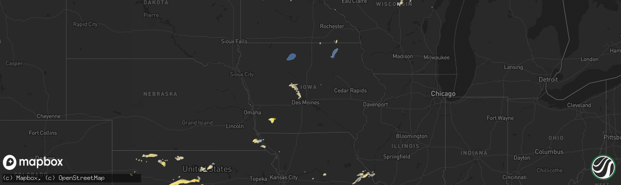
Hail Map in Iowa on June 4, 2024
The weather event in Iowa on June 4, 2024 includes Hail, Wind, and Tornado maps. 18 states and 624 cities were impacted and suffered possible damage. The total estimated number of properties impacted is 3,033.
Want more than just the map?
Turn this storm into a full workflow.
- Owner + property data so you know who to knock
- OnDemand branded weather history reports to win the "did we even have hail?" argument
- RoofTrace estimate so reps stop guessing numbers at the door
Bought this map? Upgrade within 7 days and we'll credit the $230. (10-15 min setup call)
Hail
Wind
Tornado
3,033
Estimated number of impacted properties by a 1.00" hail or larger0
Estimated number of impacted properties by a 1.75" hail or larger0
Estimated number of impacted properties by a 2.50" hail or largerStorm reports in Iowa
Iowa
| Date | Description |
|---|---|
| 06/04/20246:30 PM CDT | Phone line blow down. |
| 06/04/20246:26 PM CDT | Tree downed on some lines at the intersection of 14th and story st. Large branch down also at 14th and boone st. Delayed report... Time estimated. |
| 06/04/20246:20 PM CDT | Flag pole was bent slightly from the wind... Branches on road. Delayed report. |
| 06/04/20245:55 PM CDT | Tree blown down. |
| 06/04/20245:52 PM CDT | Powerline blown down. |
| 06/04/20245:48 PM CDT | Via raccoon valley radio. Time estimated from radar. |
| 06/04/20244:25 PM CDT | A local report indicates 63 MPH wind near 2 W Algona |
| 06/04/20244:08 PM CDT | 2 to 3 inch wide branches down at this location. Employee estimated 60 mph winds one mile southeast of location at 407 pm. |
| 06/04/20244:06 PM CDT | A local report indicates 60 MPH wind near 2 SSE Davenport Municip |
| 06/03/20247:55 PM CDT | Peak wind gust from ssw. |
All States Impacted by Hail Map on June 4, 2024
Cities Impacted by Hail Map on June 4, 2024
- Oberlin, KS
- Atwood, KS
- Norcatur, KS
- Norton, KS
- Selden, KS
- Lenora, KS
- Hill City, KS
- Colby, KS
- Winona, KS
- Phillipsburg, KS
- Glade, KS
- Kirwin, KS
- Agra, KS
- Kensington, KS
- Canton, TX
- Gaylord, KS
- Van, TX
- Ben Wheeler, TX
- Athol, KS
- Lindale, TX
- Tyler, TX
- Mineola, TX
- Chandler, TX
- Flint, TX
- Dighton, KS
- Utica, KS
- Winona, TX
- Bullard, TX
- Hays, KS
- Ellis, KS
- Ransom, KS
- Arnold, KS
- Victoria, KS
- Gorham, KS
- Burnsville, NC
- Russell, KS
- Catharine, KS
- Bison, KS
- Vining, MN
- Paradise, KS
- Natoma, KS
- Otis, KS
- Henning, MN
- Grand Cane, LA
- Thief River Falls, MN
- Saint Hilaire, MN
- Pfeifer, KS
- Bunker Hill, KS
- Hoisington, KS
- Olmitz, KS
- Solway, MN
- Mansfield, LA
- Bemidji, MN
- Kerkhoven, MN
- Murdock, MN
- Deer Creek, MN
- Luray, KS
- Lucas, KS
- Wadena, MN
- Granite Falls, MN
- Sacred Heart, MN
- Maynard, MN
- Akeley, MN
- Nevis, MN
- Claflin, KS
- Raymond, MN
- Sunburg, MN
- Dorrance, KS
- Sylvan Grove, KS
- Beloit, KS
- Tenstrike, MN
- Clara City, MN
- Wannaska, MN
- Holyrood, KS
- Lincoln, KS
- Clarissa, MN
- Eagle Bend, MN
- Hines, MN
- Osakis, MN
- Pennock, MN
- Walker, MN
- Cass Lake, MN
- Long Prairie, MN
- Mount Pleasant, NC
- Concord, NC
- Simpson, KS
- Moreauville, LA
- Glasco, KS
- Browerville, MN
- Hatley, WI
- Willmar, MN
- Concordia, KS
- Rosholt, WI
- Bushton, KS
- Monterey, LA
- Ocheyedan, IA
- Lorraine, KS
- Geneseo, KS
- Polkton, NC
- Woodville, MS
- Irma, WI
- Ellsworth, KS
- Chase, KS
- Wittenberg, WI
- Frontenac, MN
- Banks, AL
- Lyons, KS
- Brantwood, WI
- Hutchinson, MN
- Union Springs, AL
- Windom, MN
- Darwin, MN
- Phillips, WI
- Deer River, MN
- Midway, AL
- Plaucheville, LA
- Evergreen, LA
- Little River, KS
- Ridgeway, SC
- Lugoff, SC
- Cottonport, LA
- Durham, KS
- Canton, KS
- Mosinee, WI
- Madison Heights, VA
- Lynchburg, VA
- Troy, AL
- Algona, IA
- Whittemore, IA
- West Bend, IA
- Ottosen, IA
- Bode, IA
- Burt, IA
- Lu Verne, IA
- Auburn, NE
- Humboldt, NE
- Glencoe, MN
- Stevens Point, WI
- Morrow, LA
- Silver Lake, MN
- Windom, KS
- Nemaha, NE
- Brownville, NE
- Wesley, IA
- Mcpherson, KS
- Lafayette, MN
- Inman, KS
- Centreville, MS
- Liberty, MS
- Cokato, MN
- South Haven, MN
- Saint Francisville, LA
- Angola, LA
- Jackson, LA
- Zachary, LA
- Slaughter, LA
- Ethel, LA
- Wilson, LA
- Norwood, LA
- Clinton, LA
- Osyka, MS
- Greensburg, LA
- Greenwell Springs, LA
- Kentwood, LA
- Pride, LA
- Amite, LA
- Holden, LA
- Pine Grove, LA
- Denham Springs, LA
- Walker, LA
- McCall Creek, MS
- Meadville, MS
- Brookhaven, MS
- Winter, WI
- Ladysmith, WI
- Stella, NE
- Lehigh, KS
- Repton, AL
- Burns, KS
- Newton, KS
- Walton, KS
- Ellinwood, KS
- Galva, KS
- Hudson, KS
- Tigerton, WI
- Peabody, KS
- Rock Port, MO
- Fairfax, MO
- Harrisville, MS
- Florence, MS
- Crystal Springs, MS
- Richland, MS
- Terry, MS
- Georgetown, MS
- Brandon, MS
- Braxton, MS
- Pearl, MS
- Flowood, MS
- Morton, MS
- Pelahatchie, MS
- Lena, MS
- Canton, MS
- Magnolia, MS
- Mount Hermon, LA
- Fluker, LA
- Roseland, LA
- Mccomb, MS
- Tylertown, MS
- Independence, LA
- Loranger, LA
- Franklinton, LA
- Husser, LA
- Roxbury, KS
- Hillsboro, KS
- Marion, KS
- Paton, IA
- Ogden, IA
- Shubert, NE
- Florence, KS
- Cedar Point, KS
- Lindsborg, KS
- Raymond, KS
- Green Bay, WI
- Red Oak, IA
- St John, KS
- Dana, IA
- Jefferson, IA
- Stanton, IA
- Sylvia, KS
- Villisca, IA
- Sandy Hook, MS
- Angie, LA
- Bogalusa, LA
- Plevna, KS
- Grand Junction, IA
- Bowler, WI
- Boxholm, IA
- Sterling, KS
- Rulo, NE
- Falls City, NE
- Pilot Mound, IA
- Kanopolis, KS
- Abbyville, KS
- Saint Ansgar, IA
- Craig, MO
- Spring Valley, MN
- Le Roy, MN
- Elmdale, KS
- Turon, KS
- Park Falls, WI
- Cottonwood Falls, KS
- Stafford, KS
- Matfield Green, KS
- Preston, MN
- Harmony, MN
- Lime Springs, IA
- Hutchinson, KS
- Partridge, KS
- Pretty Prairie, KS
- Quitaque, TX
- Kingman, KS
- Maize, KS
- Woodward, IA
- Colwich, KS
- Whitewater, KS
- Boone, IA
- Andale, KS
- Wichita, KS
- Valley Center, KS
- Granger, IA
- Bouton, IA
- Olpe, KS
- Benton, KS
- Marenisco, MI
- Madison, KS
- Hamilton, KS
- Virgil, KS
- Mercer, WI
- Oakboro, NC
- Haysville, KS
- Emelle, AL
- Derby, KS
- Towanda, KS
- Epes, AL
- Peck, KS
- Mcconnell Afb, KS
- Clearwater, KS
- New Hampton, IA
- Ionia, IA
- Alta Vista, IA
- Elma, IA
- Cresco, IA
- Gracemont, OK
- Dallas Center, IA
- Savanna, IL
- El Dorado, KS
- Goddard, KS
- Andover, KS
- Rose Hill, KS
- Anthony, KS
- Boligee, AL
- Fort Cobb, OK
- Medford, OK
- Leon, KS
- Minco, OK
- South Haven, KS
- Wellington, KS
- Anadarko, OK
- Albion, IA
- Belle Plaine, KS
- Mulvane, KS
- Udall, KS
- Douglass, KS
- Rock, KS
- Oxford, KS
- Winfield, KS
- Atlanta, KS
- Augusta, KS
- Burden, KS
- Latham, KS
- Beaumont, KS
- Piedmont, KS
- Geuda Springs, KS
- Arkansas City, KS
- Eutaw, AL
- Attica, KS
- Oklahoma City, OK
- Mustang, OK
- Tuttle, OK
- Pocasset, OK
- Neosho Falls, KS
- Wilsonville, AL
- Yates Center, KS
- Piqua, KS
- Union City, OK
- Kechi, KS
- Cambridge, KS
- Choctaw, OK
- Iola, KS
- Colony, KS
- Harrah, OK
- Keshena, WI
- Amber, OK
- Vincent, AL
- Harpersville, AL
- Yukon, OK
- Newcastle, OK
- Blanchard, OK
- Sterrett, AL
- Mcloud, OK
- Madrid, IA
- La Harpe, KS
- Minburn, IA
- Blackwell, OK
- Gridley, KS
- Caldwell, KS
- Shawnee, OK
- Humboldt, KS
- Suring, WI
- Mountain, WI
- Newalla, OK
- Norman, OK
- Nardin, OK
- Braman, OK
- Lawton, OK
- Tonkawa, OK
- Cement, OK
- Moran, KS
- Prague, OK
- Elgin, OK
- Paden, OK
- Meeker, OK
- Noble, OK
- Macomb, OK
- Tecumseh, OK
- Billings, OK
- Greenwich, KS
- Depew, OK
- Bristow, OK
- Castle, OK
- Cache, OK
- Stroud, OK
- Medicine Park, OK
- Beggs, OK
- Mounds, OK
- Broken Arrow, OK
- Okmulgee, OK
- Perry, OK
- Marlow, OK
- Faxon, OK
- Douglas, OK
- Coweta, OK
- Haskell, OK
- Orlando, OK
- Stillwater, OK
- Mulhall, OK
- Coyle, OK
- Elmore City, OK
- Duncan, OK
- Bixby, OK
- Foster, OK
- Morris, OK
- Porter, OK
- Boynton, OK
- Oktaha, OK
- Okemah, OK
- Healdton, OK
- Wagoner, OK
- Ratliff City, OK
- Graham, OK
- Walters, OK
- Sedgwick, KS
- Norborne, MO
- Eufaula, OK
- Devol, OK
- Randlett, OK
- Savannah, MO
- Hanna, OK
- Indianola, OK
- Checotah, OK
- Sheldon, MO
- Nevada, MO
- Moundville, MO
- Redbird, OK
- Marshall, MO
- Wilson, OK
- La Cygne, KS
- Lamar, MO
- Evergreen, AL
- Antlers, OK
- Tussy, OK
- Ringling, OK
- Keysville, GA
- Louisville, GA
- Waynesboro, GA
- Overbrook, OK
- Burneyville, OK
- Saint Jo, TX
- Leon, OK
- Hennepin, OK
- Wilburton, OK
- Fayette, MO
- Springer, OK
- Nocona, TX
- Gainesville, TX
- Muenster, TX
- Glasgow, MO
- Wichita Falls, TX
- Fort Sill, OK
- Gentry, AR
- Buffalo, MO
- Chickasha, OK
- Ninnekah, OK
- Apache, OK
- Lindsay, TX
- Forestburg, TX
- Ardmore, OK
- Phillipsburg, MO
- Long Lane, MO
- Lebanon, MO
- Lone Grove, OK
- Collinsville, TX
- Valley View, TX
- New Florence, MO
- Montgomery City, MO
- Era, TX
- Tioga, TX
- Gunter, TX
- Celina, TX
- Van Alstyne, TX
- Bellflower, MO
- Truxton, MO
- High Hill, MO
- Jonesburg, MO
- Middletown, MO
- Bowling Green, MO
- Locust, NC
- Silex, MO
- Howe, TX
- Anna, TX
- Eolia, MO
- Troy, MO
- Elsberry, MO
- Sanger, TX
- Denton, TX
- Krum, TX
- Little Elm, TX
- Aubrey, TX
- Clarksville, MO
- Hamburg, IL
- Rhome, TX
- Batchtown, IL
- Argyle, TX
- Hardin, IL
- Foley, MO
- Justin, TX
- Ponder, TX
- Flower Mound, TX
- Haslet, TX
- White Hall, IL
- Roodhouse, IL
- Greenfield, IL
- Jerseyville, IL
- Kane, IL
- Roanoke, TX
- Fort Worth, TX
- Keller, TX
- Southlake, TX
- Carrollton, IL
- Rockbridge, IL
- Brighton, IL
- Palmyra, IL
- Modesto, IL
- Medora, IL
- Montalba, TX
- Tennessee Colony, TX
- Kennedale, TX
- Arlington, TX
- Piasa, IL
- Shipman, IL
- Burrton, KS
- Mount Hope, KS
- Haven, KS
- Halstead, KS
- Mansfield, TX
- Burleson, TX
- Grand Prairie, TX
- Cleburne, TX
- Alvarado, TX
- Venus, TX
- Grandview, TX
- Covington, TX
- Blum, TX
- Glenmora, LA
- Smithdale, MS
- North Richland Hills, TX
- Haltom City, TX
- Hurst, TX
- Euless, TX
- Hillsboro, TX
- Whitney, TX
- Washington, OK
- Lexington, OK
- Wanette, OK
- Maud, OK
- Seminole, OK
- Earlsboro, OK
- Wewoka, OK
- Holdenville, OK
- Bowlegs, OK
- Asher, OK
- Sasakwa, OK
- Konawa, OK
- Calvin, OK
- Stuart, OK
- Stratford, OK
- Atwood, OK
- Allen, OK
- Fitzhugh, OK
- Stonewall, OK
- Ada, OK
- Byars, OK
- Sulphur, OK
- Tishomingo, OK
- Mill Creek, OK
- Roff, OK
- Fittstown, OK
- Pauls Valley, OK
- Dougherty, OK
- Wynnewood, OK
- Davis, OK
- Wayne, OK
- Paoli, OK
- Maysville, OK
- Lindsay, OK
- Purcell, OK
- Alex, OK
- Tupelo, OK
- Centrahoma, OK
- Coalgate, OK
- Milburn, OK
- Mannsville, OK
- Wapanucka, OK
- Coleman, OK
- Kenefic, OK
- Atoka, OK
- Madill, OK
- Caddo, OK
- Durant, OK
- Mead, OK
- Loco, OK
- Marietta, OK
- Whitesboro, TX
- Kingston, OK
- Lebanon, OK
- Bokchito, OK
- Pottsboro, TX
- Cartwright, OK
- Calera, OK
- Sherman, TX
- Savoy, TX
- Ravenna, TX
- Hendrix, OK
- Bells, TX
- Thackerville, OK
- Gordonville, TX
- Denison, TX
- Colbert, OK
- Sadler, TX
- Whitewright, TX
- Tom Bean, TX
- Carney, OK
- Perkins, OK
- Wellston, OK
- Chandler, OK
- Sparks, OK
- Meridian, OK
- Muskogee, OK
- Fort Gibson, OK
- Braggs, OK
- Biloxi, MS
- Fountain, MN
- Wykoff, MN
- Chatfield, MN


