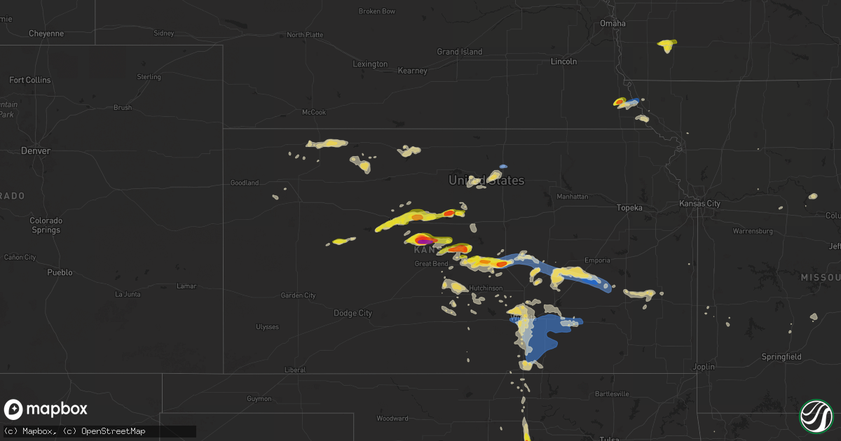
Hail Map on June 4, 2024
Get this storm
June 4 map
$229
one time, instant access
Download today. No call, no setup
Keep the $229
Bought the map and want the full workflow? Apply the entire $229 to a subscription within 7 days. None of it is wasted.
Every map, not just this one
This buys you this map. Subscription and you get every map we run, in the markets you choose from a few cities to whole states to nationwide. Plus real-time alerts the moment a storm fires.
Contact data
Name, contact info, occupancy, even credit band for addresses in the footprint. You go from where it hit to who to call.
Become the source they trust
Unlimited branding weather history reports on demand. You already have the documented answer ready for the property owner, and you are the one who showed up with it.
Property data and RoofTrace estimates
Pull up any address you have got, its value and the exact code rules for that jurisdiction, straight from One Click Code. Then RoofTrace estimates the squares, pitch, and roof value, priced the way you price.
States Impacted by Hail Map on June 4, 2024
Storm reports
Kentucky
| Date | Description |
|---|---|
| 06/04/20243:55 PM CDT | Via wkyt... Social media post of large tree limbs around 1300-1400 delong rd. |
| 06/04/202412:23 PM CDT | Report of limps down that snapped power pole along highway 42 near greenhaven lane. Via nws chat. |
Missouri
| Date | Description |
|---|---|
| 06/04/20244:02 AM CDT | Tree down near county road 272 and highway 54. |
| 06/03/202411:05 PM CDT | Delayed report of large tree limb downed at excelsior springs dog park. Time estimated from radar. |
Ohio
| Date | Description |
|---|---|
| 06/04/20246:10 PM CDT | 2 trees down. |
| 06/04/20246:04 PM CDT | Trees down. |
Illinois
| Date | Description |
|---|---|
| 06/04/20244:55 PM CDT | Tree downed. Time estimated using radar. |
| 06/04/20246:10 AM CDT | Relayed via social media. Multiple tree limbs down... Some up to 4 inches in diameter. |
| 06/04/20244:20 AM CDT | Sizeable tree branch down |
| 06/04/202412:37 AM CDT | Multiple public reports of tree damage in albany park... Irving park... And avondale community areas of chicago. Relayed by chicago311. Time estimated by radar. |
| 06/04/202412:29 AM CDT | Multiple public reports of tree damage in austin community area of chicago. Relayed by chicago311. Time estimated by radar. |
| 06/03/202411:38 PM CDT | Corrects previous tstm wnd dmg report from 2 nnw aurora. Sizeable tree branch down |
| 06/03/202411:35 PM CDT | Large tree branch downed. Additional public reports of tree damage in the same general area. Time estimated by radar. |
| 06/03/202411:30 PM CDT | Photo shows small tree with trunk snapped in oswego. Time estimated by radar. |
| 06/03/20247:56 PM CDT | Large tree blown down on a house on oakley avenue. |
| 06/03/20247:13 PM CDT | Measured wind gust to 67 mph at nws office in romeoville. |
Kansas
| Date | Description |
|---|---|
| 06/04/20246:41 PM CDT | Along highway 177. |
| 06/04/20245:47 PM CDT | 50 to 60 mph at marion reservoir. |
| 06/04/20245:29 PM CDT | A local report indicates 70 MPH wind near 4 S Durham |
| 06/04/20245:12 PM CDT | Report came in via social media. |
| 06/04/20245:09 PM CDT | Report from mping: quarter |
| 06/04/20245:08 PM CDT | A local report indicates 1.00 inch wind near Mcpherson |
| 06/04/20245:06 PM CDT | Along highway 61. Courtesy of kake tv. |
| 06/04/20245:00 PM CDT | Kake meteorologist reports stronger than 60 mph winds. |
| 06/04/20244:24 PM CDT | Picture on social media relayed via kwch. |
| 06/04/20243:26 PM CDT | A local report indicates 1.75 inch wind near 1 NE Frederick |
| 06/04/20243:17 PM CDT | A local report indicates 1.00 inch wind near 3 WNW Geneseo |
| 06/04/20243:02 PM CDT | Picture relayed via social media from kwch. |
| 06/04/20243:01 PM CDT | Report of roof damage and tin sheds destroyed at 160th and noble roads. |
| 06/04/20243:00 PM CDT | Power lines down. |
| 06/04/20242:53 PM CDT | Kcnk. |
| 06/04/20242:50 PM CDT | A local report indicates 1.00 inch wind near Holyrood |
| 06/04/20242:48 PM CDT | Spotter reported quarter to ping-pong ball sized hail. |
| 06/04/20242:00 PM CDT | Army corps of engineers had mainly nickel to quarter sized with a few larger than golf balls. Time is estimated. |
| 06/04/20241:43 PM CDT | Quarter to half dollar sized hail. Time is estimated from radar. |
| 06/04/20241:20 PM CDT | Mostly smaller pea sized hail but a few golf ball sized hail pieces. |
| 06/04/20241:05 PM CDT | Kake relayed a picture of tennis ball sized hail. Time is estimated from radar. |
| 06/04/202412:18 PM CDT | A local report indicates 1.00 inch wind near 2 WNW Hays |
| 06/04/202412:18 PM CDT | Report from mping: quarter |
| 06/04/202411:47 AM CDT | A local report indicates 1.25 inch wind near 9 ESE Cedar Bluff |
| 06/04/202410:57 AM CDT | A local report indicates 1.25 inch wind near 4 E Pendennis |
| 06/03/20248:22 PM CDT | Estimated 60 mph gusts... Small tree limb damage. |
| 06/03/20248:16 PM CDT | A local report indicates 60 MPH wind near Derby |
| 06/03/20248:16 PM CDT | Large trees bending over. |
| 06/03/20248:12 PM CDT | Report from mping: 1-inch tree limbs broken; shingles blown off. |
| 06/03/20247:46 PM CDT | Report from mping: 3-inch tree limbs broken; power poles broken. |
| 06/03/20247:43 PM CDT | Estimating 50 to 60 mph winds near pawnee and seneca. Courtesy of ks storm info. |
| 06/03/20247:36 PM CDT | Measured by a personal weather station. |
| 06/03/20247:28 PM CDT | A local report indicates 58 MPH wind near Wichita Eisenhower Airp |
| 06/03/20247:21 PM CDT | Trained spotter reported wind gusts estimated over 80 mph. Tops of trees snapped off. Small hail below quarter size as well. |
| 06/03/20247:20 PM CDT | Delayed report from kwch media. |
Iowa
| Date | Description |
|---|---|
| 06/04/20246:30 PM CDT | Phone line blow down. |
| 06/04/20246:26 PM CDT | Tree downed on some lines at the intersection of 14th and story st. Large branch down also at 14th and boone st. Delayed report... Time estimated. |
| 06/04/20246:20 PM CDT | Flag pole was bent slightly from the wind... Branches on road. Delayed report. |
| 06/04/20245:55 PM CDT | Tree blown down. |
| 06/04/20245:52 PM CDT | Powerline blown down. |
| 06/04/20245:48 PM CDT | Via raccoon valley radio. Time estimated from radar. |
| 06/04/20244:25 PM CDT | A local report indicates 63 MPH wind near 2 W Algona |
| 06/04/20244:08 PM CDT | 2 to 3 inch wide branches down at this location. Employee estimated 60 mph winds one mile southeast of location at 407 pm. |
| 06/04/20244:06 PM CDT | A local report indicates 60 MPH wind near 2 SSE Davenport Municip |
| 06/03/20247:55 PM CDT | Peak wind gust from ssw. |
South Carolina
| Date | Description |
|---|---|
| 06/04/20243:44 PM CDT | Reported a tree down on a power line along hope road near old river road. |
| 06/04/20242:48 PM CDT | Reported a tree on a powerline along farm road. |
| 06/04/20242:29 PM CDT | Reported tree down blocking happy town road near the town of swansea. |
| 06/04/20242:27 PM CDT | Reported a tree down across the roadway at huckabee mill road near the town of swansea. |
| 06/04/20242:18 PM CDT | Sc dept of public safety reported a tree down along platt springs road. Time estimated by radar. |
| 06/04/20241:13 PM CDT | Reported power line down in the roadway near two notch road and s. Lake drive. |
North Carolina
| Date | Description |
|---|---|
| 06/04/20246:50 PM CDT | Trees down... Including one on a house. |
| 06/04/20242:36 PM CDT | A couple of trees were blown down in the green creek area. |
| 06/04/20242:07 PM CDT | A retired fire department employee reported mostly pea sized hail with a few hail stones quarter sized. The storm started with near 40mph gusts then decreased to 15 to |
Texas
| Date | Description |
|---|---|
| 06/04/20243:37 AM CDT | Large branch broken off mature tree. Blocking roadway in frisco at prestmont pl and ohio dr. |
| 06/04/20243:20 AM CDT | Guinn hall at twu reported a measured 59 mph wind gust. |
| 06/04/20243:05 AM CDT | First of numerous trees down in the linden area at 3:05a.m. On tx hwy 155. |
| 06/04/20242:44 AM CDT | Report from mping: 1-inch tree limbs broken; shingles blown off. |
| 06/04/20242:10 AM CDT | Power line and tree damage reported in collinsville. |
| 06/04/20241:35 AM CDT | 50 knot wind gust measured at the gainesville airport. |
| 06/04/202412:37 AM CDT | Oak tree on fm 131. |
Georgia
| Date | Description |
|---|---|
| 06/04/20245:50 PM CDT | Reported large limbs needed to be cleared along hwy. 305 near the st. Clair community. |
| 06/04/20245:44 PM CDT | Reported multiple power lines down along property at pebble road near st. Clair road. |
Nebraska
| Date | Description |
|---|---|
| 06/04/20244:54 PM CDT | Personal weather station. |
Mississippi
| Date | Description |
|---|---|
| 06/04/20246:50 PM CDT | Numerous trees down across southern forrest county. |
| 06/04/20246:45 PM CDT | Awning torn off at baxterville school & roof blown off an on-campus storage building. |
| 06/04/20246:43 PM CDT | Numerous trees reported down across numerous roads in marion county. |
| 06/04/20246:40 PM CDT | Trees were downed in seminary. Report via facebook. |
| 06/04/20246:33 PM CDT | Tree down on highway 12 west in kosciusko. Another tree reported down in kosciusko... On county road 5131. |
| 06/04/20246:33 PM CDT | Five trees reported down in the northeast part of covington county. |
| 06/04/20246:32 PM CDT | Trees down across highway 28 near mize. Possible tornado. |
| 06/04/20246:32 PM CDT | Corrects previous tstm wnd dmg report from 1 w mize. Trees were blown down across highway 28 near the intersection of cr 64... And a power pole was snapped. A damage su |
| 06/04/20246:30 PM CDT | Trees down in picayune. |
| 06/04/20246:25 PM CDT | *** 1 fatal *** a 55-foot tall mobile oil well tower was blown over near ms highway 28 and mangum garner road. A 24-year old male worker on the tower died when the towe |
| 06/04/20246:22 PM CDT | Tree down on highway 429 in sallis. |
| 06/04/20246:05 PM CDT | Trees down in the prentiss area on the following roads: polk trail... George deen... Greens creek... Clem... And granby. |
| 06/04/20245:59 PM CDT | Power lines downed near ms 43 and ms 478. Report via facebook. |
| 06/04/20245:52 PM CDT | Several trees reported down across the county just to the west and north of carthage. |
| 06/04/20245:47 PM CDT | Trees down on the natchez trace parkway near mile marker 136. |
| 06/04/20245:26 PM CDT | Sporadic trees reported down across lincoln county. |
| 06/04/20245:12 PM CDT | Widespread tree damage from osyka to magnolia to fernwood. Trees reported on houses and vehicles as well. No other details at this time. Possible tornado. |
| 06/04/20245:10 PM CDT | Large wooden light pole pushed over at a ballfield near the mississippi job corps center. |
| 06/04/20245:09 PM CDT | 10-15 trees reported down within the city limits of brookhaven. |
| 06/04/20244:58 PM CDT | A tree was blown down into power lines behind sunline drive. Branches were also blown down in the area. |
| 06/04/20244:57 PM CDT | Measured with portable anemometer. |
| 06/04/20244:56 PM CDT | Stop lights blown down along hwy 18 at the overpass of interstate 20. |
| 06/04/20244:54 PM CDT | Sporadic trees reported down across copiah county. |
| 06/04/20244:48 PM CDT | Numerous trees down all along thomasville rd. |
| 06/04/20244:45 PM CDT | A tree fell on a home on will o wisp way... Resulting in a house fire. |
| 06/04/20244:43 PM CDT | Tree down at the intersection of flowers rd & kimbell rd. |
| 06/04/20244:28 PM CDT | Corrects previous tstm wnd dmg report from centreville. Widespread trees damage. Many uprooted and/or snapped in centreville. |
| 06/04/20244:28 PM CDT | Trees down in centreville. |
| 06/03/20247:56 PM CDT | Tree downed on power lines along estelle ave. |
| 06/03/20247:36 PM CDT | Widespread tree damage across the county from west to east... Mainly north of i-10. |
| 06/03/20247:35 PM CDT | Corrects previous tstm wnd dmg report from 2 wnw ocean springs. Mdot district 6 engineer reported high winds damaged the devices that operate the arms that raise and lo |
| 06/03/20247:05 PM CDT | Numerous trees down within the hattiesburg city limits. |
Louisiana
| Date | Description |
|---|---|
| 06/04/20246:39 PM CDT | Two trees snapped and fell on a large shed off of susan ln in slidell. |
| 06/04/20246:34 PM CDT | Knew asos... Lakefront airport recorded a wind gust of 60 mph. |
| 06/04/20245:11 PM CDT | Trees and power lines down along la 1054 just south of troy spears rd. |
| 06/04/20245:11 PM CDT | Trees down and blocking both northbound and southbound lanes of i-55 at amite. Possible tornado. |
| 06/04/20245:08 PM CDT | Widespread trees down across the parish reported be em. More details expected later. |
| 06/04/20245:05 PM CDT | Multiple trees down around kentwood. |
| 06/04/20245:03 PM CDT | Multiple trees down are southeastern st helena parish. |
| 06/04/20244:59 PM CDT | Widespread tree damage across the area. |
| 06/04/20244:55 PM CDT | Powerlines down on cheray dr. Relayed via social media. |
| 06/04/20244:48 PM CDT | Large oak tree snapped on lazy lake dr. |
| 06/04/20244:32 PM CDT | Widespread tree and powerline damage across the area. Further details will be sent later. |
| 06/04/20244:20 PM CDT | Widespread tree and powerline damage reported by the parish. More details still to come. |
| 06/04/20243:45 PM CDT | Tree down on car at highway 1 in mansura. No injury. |
| 06/04/20242:11 PM CDT | A tree was blown down across coco bed road in the cloutierville community. |
| 06/04/20241:45 PM CDT | A large tree was downed at the 3000 block of north blvd in provencal. |
| 06/04/20243:38 AM CDT | Numerous trees down in the rodessa... Hosston and ida vicinities. |
Minnesota
| Date | Description |
|---|---|
| 06/04/20246:47 PM CDT | Relayed through dispatch. |
| 06/04/20246:35 PM CDT | Several trees and a couple of power lines blown down. |
| 06/04/20246:33 PM CDT | Tree blown down onto a power line. |
| 06/04/20246:31 PM CDT | Report from mping: trees uprooted or snapped; roof blown off. |
| 06/04/20246:20 PM CDT | Corrects previous non-tstm wnd gst report from 7 s etna. Mesonet station mn145 u.s.63 - le roy - mp 0.5. |
| 06/04/20245:50 PM CDT | A local report indicates 61 MPH wind near 1 N Mounds View |
| 06/04/20245:10 PM CDT | Found on a public facebook page. Report of a tree through a house. Other reports of trees down in the area. |
| 06/04/20244:55 PM CDT | 14 inch diameter tree down... Signs down at lexington ave and pheasant ridge dr. |
| 06/04/20244:51 PM CDT | Photo sent via facebook of 2 large trees blocking the road. |
| 06/04/20244:46 PM CDT | 3 inch diameter branches blown off trees and smaller. |
| 06/04/20244:45 PM CDT | Report of a huge and healthy... But old... Maple tree that snapped over a powerline 0.5 miles sw of this location... And a 2 ft in diameter pine that had fallen over cr |
| 06/04/20244:19 PM CDT | *** 1 inj *** relayed report from sheriffs office of a shed with roof blown off and sides collapsed. |
| 06/04/20243:39 PM CDT | *** 1 inj *** corrects previous tstm wnd dmg report from 7 n hutchinson. Relayed report from sheriffs office of a shed with roof blown off and sides collapsed. |
| 06/04/20241:48 PM CDT | A few small tree branches down. Power lines down. Also reported dime sized hail. |
| 06/04/20241:39 PM CDT | Mature tree damage and downed power lines. |
| 06/03/20247:36 PM CDT | Large tree down on house near 10th st & lake elmo ave. |
| 06/03/20247:05 PM CDT | Corrects previous tstm wnd dmg report from chatfield. Several large tree branches blown down onto a house. |
Virginia
| Date | Description |
|---|---|
| 06/04/20244:50 PM CDT | Tree down on fletchers level road. |
| 06/04/20244:30 PM CDT | One tree down near cleburne boulevard and old cloyd road. |
| 06/04/20244:30 PM CDT | Tree down on kenmore road. |
| 06/04/20244:27 PM CDT | Tree and wires down on highland road. |
| 06/04/20243:57 PM CDT | Tree down blocking the roadway. |
Oklahoma
| Date | Description |
|---|---|
| 06/04/202412:25 AM CDT | A local report indicates 59 MPH wind near 3 NNE Sparks |
| 06/04/202412:15 AM CDT | Tree fell on house. |
| 06/03/202411:50 PM CDT | Spotter measured winds at hwy 69 and the arkansas river. |
| 06/03/202411:42 PM CDT | Nickel size hail also falling at location; hwy 69 and muskogee tpke junction. |
| 06/03/202411:15 PM CDT | A local report indicates 58 MPH wind near 1 N Ringling |
| 06/03/202411:15 PM CDT | A local report indicates 60 MPH wind near 7 NNW Velma |
| 06/03/202410:30 PM CDT | A local report indicates 2.75 inch wind near Cache |
| 06/03/202410:25 PM CDT | Several reports of downed power lines and power outages. |
| 06/03/202410:13 PM CDT | Report from mping: half dollar |
| 06/03/20249:34 PM CDT | A local report indicates 58 MPH wind near 3 ENE Washington |
Alabama
| Date | Description |
|---|---|
| 06/04/20246:46 AM CDT | Tree down in the bexar community. Location and time estimated by radar. |
Cities Impacted by Hail Map on June 4, 2024
- Oberlin, KS
- Atwood, KS
- Norcatur, KS
- Norton, KS
- Selden, KS
- Lenora, KS
- Hill City, KS
- Colby, KS
- Winona, KS
- Phillipsburg, KS
- Glade, KS
- Kirwin, KS
- Agra, KS
- Kensington, KS
- Canton, TX
- Gaylord, KS
- Van, TX
- Ben Wheeler, TX
- Athol, KS
- Lindale, TX
- Tyler, TX
- Mineola, TX
- Chandler, TX
- Flint, TX
- Dighton, KS
- Utica, KS
- Winona, TX
- Bullard, TX
- Hays, KS
- Ellis, KS
- Ransom, KS
- Arnold, KS
- Victoria, KS
- Gorham, KS
- Burnsville, NC
- Russell, KS
- Catharine, KS
- Bison, KS
- Vining, MN
- Paradise, KS
- Natoma, KS
- Otis, KS
- Henning, MN
- Grand Cane, LA
- Thief River Falls, MN
- Saint Hilaire, MN
- Pfeifer, KS
- Bunker Hill, KS
- Hoisington, KS
- Olmitz, KS
- Solway, MN
- Mansfield, LA
- Bemidji, MN
- Kerkhoven, MN
- Murdock, MN
- Deer Creek, MN
- Luray, KS
- Lucas, KS
- Wadena, MN
- Granite Falls, MN
- Sacred Heart, MN
- Maynard, MN
- Akeley, MN
- Nevis, MN
- Claflin, KS
- Raymond, MN
- Sunburg, MN
- Dorrance, KS
- Sylvan Grove, KS
- Beloit, KS
- Tenstrike, MN
- Clara City, MN
- Wannaska, MN
- Holyrood, KS
- Lincoln, KS
- Clarissa, MN
- Eagle Bend, MN
- Hines, MN
- Osakis, MN
- Pennock, MN
- Walker, MN
- Cass Lake, MN
- Long Prairie, MN
- Mount Pleasant, NC
- Concord, NC
- Simpson, KS
- Moreauville, LA
- Glasco, KS
- Browerville, MN
- Hatley, WI
- Willmar, MN
- Concordia, KS
- Rosholt, WI
- Bushton, KS
- Monterey, LA
- Ocheyedan, IA
- Lorraine, KS
- Geneseo, KS
- Polkton, NC
- Woodville, MS
- Irma, WI
- Ellsworth, KS
- Chase, KS
- Wittenberg, WI
- Frontenac, MN
- Banks, AL
- Lyons, KS
- Brantwood, WI
- Hutchinson, MN
- Union Springs, AL
- Windom, MN
- Darwin, MN
- Phillips, WI
- Deer River, MN
- Midway, AL
- Plaucheville, LA
- Evergreen, LA
- Little River, KS
- Ridgeway, SC
- Lugoff, SC
- Cottonport, LA
- Durham, KS
- Canton, KS
- Mosinee, WI
- Madison Heights, VA
- Lynchburg, VA
- Troy, AL
- Algona, IA
- Whittemore, IA
- West Bend, IA
- Ottosen, IA
- Bode, IA
- Burt, IA
- Lu Verne, IA
- Auburn, NE
- Humboldt, NE
- Glencoe, MN
- Stevens Point, WI
- Morrow, LA
- Silver Lake, MN
- Windom, KS
- Nemaha, NE
- Brownville, NE
- Wesley, IA
- Mcpherson, KS
- Lafayette, MN
- Inman, KS
- Centreville, MS
- Liberty, MS
- Cokato, MN
- South Haven, MN
- Saint Francisville, LA
- Angola, LA
- Jackson, LA
- Zachary, LA
- Slaughter, LA
- Ethel, LA
- Wilson, LA
- Norwood, LA
- Clinton, LA
- Osyka, MS
- Greensburg, LA
- Greenwell Springs, LA
- Kentwood, LA
- Pride, LA
- Amite, LA
- Holden, LA
- Pine Grove, LA
- Denham Springs, LA
- Walker, LA
- McCall Creek, MS
- Meadville, MS
- Brookhaven, MS
- Winter, WI
- Ladysmith, WI
- Stella, NE
- Lehigh, KS
- Repton, AL
- Burns, KS
- Newton, KS
- Walton, KS
- Ellinwood, KS
- Galva, KS
- Hudson, KS
- Tigerton, WI
- Peabody, KS
- Rock Port, MO
- Fairfax, MO
- Harrisville, MS
- Florence, MS
- Crystal Springs, MS
- Richland, MS
- Terry, MS
- Georgetown, MS
- Brandon, MS
- Braxton, MS
- Pearl, MS
- Flowood, MS
- Morton, MS
- Pelahatchie, MS
- Lena, MS
- Canton, MS
- Magnolia, MS
- Mount Hermon, LA
- Fluker, LA
- Roseland, LA
- Mccomb, MS
- Tylertown, MS
- Independence, LA
- Loranger, LA
- Franklinton, LA
- Husser, LA
- Roxbury, KS
- Hillsboro, KS
- Marion, KS
- Paton, IA
- Ogden, IA
- Shubert, NE
- Florence, KS
- Cedar Point, KS
- Lindsborg, KS
- Raymond, KS
- Green Bay, WI
- Red Oak, IA
- St John, KS
- Dana, IA
- Jefferson, IA
- Stanton, IA
- Sylvia, KS
- Villisca, IA
- Sandy Hook, MS
- Angie, LA
- Bogalusa, LA
- Plevna, KS
- Grand Junction, IA
- Bowler, WI
- Boxholm, IA
- Sterling, KS
- Rulo, NE
- Falls City, NE
- Pilot Mound, IA
- Kanopolis, KS
- Abbyville, KS
- Saint Ansgar, IA
- Craig, MO
- Spring Valley, MN
- Le Roy, MN
- Elmdale, KS
- Turon, KS
- Park Falls, WI
- Cottonwood Falls, KS
- Stafford, KS
- Matfield Green, KS
- Preston, MN
- Harmony, MN
- Lime Springs, IA
- Hutchinson, KS
- Partridge, KS
- Pretty Prairie, KS
- Quitaque, TX
- Kingman, KS
- Maize, KS
- Woodward, IA
- Colwich, KS
- Whitewater, KS
- Boone, IA
- Andale, KS
- Wichita, KS
- Valley Center, KS
- Granger, IA
- Bouton, IA
- Olpe, KS
- Benton, KS
- Marenisco, MI
- Madison, KS
- Hamilton, KS
- Virgil, KS
- Mercer, WI
- Oakboro, NC
- Haysville, KS
- Emelle, AL
- Derby, KS
- Towanda, KS
- Epes, AL
- Peck, KS
- Mcconnell Afb, KS
- Clearwater, KS
- New Hampton, IA
- Ionia, IA
- Alta Vista, IA
- Elma, IA
- Cresco, IA
- Gracemont, OK
- Dallas Center, IA
- Savanna, IL
- El Dorado, KS
- Goddard, KS
- Andover, KS
- Rose Hill, KS
- Anthony, KS
- Boligee, AL
- Fort Cobb, OK
- Medford, OK
- Leon, KS
- Minco, OK
- South Haven, KS
- Wellington, KS
- Anadarko, OK
- Albion, IA
- Belle Plaine, KS
- Mulvane, KS
- Udall, KS
- Douglass, KS
- Rock, KS
- Oxford, KS
- Winfield, KS
- Atlanta, KS
- Augusta, KS
- Burden, KS
- Latham, KS
- Beaumont, KS
- Piedmont, KS
- Geuda Springs, KS
- Arkansas City, KS
- Eutaw, AL
- Attica, KS
- Oklahoma City, OK
- Mustang, OK
- Tuttle, OK
- Pocasset, OK
- Neosho Falls, KS
- Wilsonville, AL
- Yates Center, KS
- Piqua, KS
- Union City, OK
- Kechi, KS
- Cambridge, KS
- Choctaw, OK
- Iola, KS
- Colony, KS
- Harrah, OK
- Keshena, WI
- Amber, OK
- Vincent, AL
- Harpersville, AL
- Yukon, OK
- Newcastle, OK
- Blanchard, OK
- Sterrett, AL
- Mcloud, OK
- Madrid, IA
- La Harpe, KS
- Minburn, IA
- Blackwell, OK
- Gridley, KS
- Caldwell, KS
- Shawnee, OK
- Humboldt, KS
- Suring, WI
- Mountain, WI
- Newalla, OK
- Norman, OK
- Nardin, OK
- Braman, OK
- Lawton, OK
- Tonkawa, OK
- Cement, OK
- Moran, KS
- Prague, OK
- Elgin, OK
- Paden, OK
- Meeker, OK
- Noble, OK
- Macomb, OK
- Tecumseh, OK
- Billings, OK
- Greenwich, KS
- Depew, OK
- Bristow, OK
- Castle, OK
- Cache, OK
- Stroud, OK
- Medicine Park, OK
- Beggs, OK
- Mounds, OK
- Broken Arrow, OK
- Okmulgee, OK
- Perry, OK
- Marlow, OK
- Faxon, OK
- Douglas, OK
- Coweta, OK
- Haskell, OK
- Orlando, OK
- Stillwater, OK
- Mulhall, OK
- Coyle, OK
- Elmore City, OK
- Duncan, OK
- Bixby, OK
- Foster, OK
- Morris, OK
- Porter, OK
- Boynton, OK
- Oktaha, OK
- Okemah, OK
- Healdton, OK
- Wagoner, OK
- Ratliff City, OK
- Graham, OK
- Walters, OK
- Sedgwick, KS
- Norborne, MO
- Eufaula, OK
- Devol, OK
- Randlett, OK
- Savannah, MO
- Hanna, OK
- Indianola, OK
- Checotah, OK
- Sheldon, MO
- Nevada, MO
- Moundville, MO
- Redbird, OK
- Marshall, MO
- Wilson, OK
- La Cygne, KS
- Lamar, MO
- Evergreen, AL
- Antlers, OK
- Tussy, OK
- Ringling, OK
- Keysville, GA
- Louisville, GA
- Waynesboro, GA
- Overbrook, OK
- Burneyville, OK
- Saint Jo, TX
- Leon, OK
- Hennepin, OK
- Wilburton, OK
- Fayette, MO
- Springer, OK
- Nocona, TX
- Gainesville, TX
- Muenster, TX
- Glasgow, MO
- Wichita Falls, TX
- Fort Sill, OK
- Gentry, AR
- Buffalo, MO
- Chickasha, OK
- Ninnekah, OK
- Apache, OK
- Lindsay, TX
- Forestburg, TX
- Ardmore, OK
- Phillipsburg, MO
- Long Lane, MO
- Lebanon, MO
- Lone Grove, OK
- Collinsville, TX
- Valley View, TX
- New Florence, MO
- Montgomery City, MO
- Era, TX
- Tioga, TX
- Gunter, TX
- Celina, TX
- Van Alstyne, TX
- Bellflower, MO
- Truxton, MO
- High Hill, MO
- Jonesburg, MO
- Middletown, MO
- Bowling Green, MO
- Locust, NC
- Silex, MO
- Howe, TX
- Anna, TX
- Eolia, MO
- Troy, MO
- Elsberry, MO
- Sanger, TX
- Denton, TX
- Krum, TX
- Little Elm, TX
- Aubrey, TX
- Clarksville, MO
- Hamburg, IL
- Rhome, TX
- Batchtown, IL
- Argyle, TX
- Hardin, IL
- Foley, MO
- Justin, TX
- Ponder, TX
- Flower Mound, TX
- Haslet, TX
- White Hall, IL
- Roodhouse, IL
- Greenfield, IL
- Jerseyville, IL
- Kane, IL
- Roanoke, TX
- Fort Worth, TX
- Keller, TX
- Southlake, TX
- Carrollton, IL
- Rockbridge, IL
- Brighton, IL
- Palmyra, IL
- Modesto, IL
- Medora, IL
- Montalba, TX
- Tennessee Colony, TX
- Kennedale, TX
- Arlington, TX
- Piasa, IL
- Shipman, IL
- Burrton, KS
- Mount Hope, KS
- Haven, KS
- Halstead, KS
- Mansfield, TX
- Burleson, TX
- Grand Prairie, TX
- Cleburne, TX
- Alvarado, TX
- Venus, TX
- Grandview, TX
- Covington, TX
- Blum, TX
- Glenmora, LA
- Smithdale, MS
- North Richland Hills, TX
- Haltom City, TX
- Hurst, TX
- Euless, TX
- Hillsboro, TX
- Whitney, TX
- Washington, OK
- Lexington, OK
- Wanette, OK
- Maud, OK
- Seminole, OK
- Earlsboro, OK
- Wewoka, OK
- Holdenville, OK
- Bowlegs, OK
- Asher, OK
- Sasakwa, OK
- Konawa, OK
- Calvin, OK
- Stuart, OK
- Stratford, OK
- Atwood, OK
- Allen, OK
- Fitzhugh, OK
- Stonewall, OK
- Ada, OK
- Byars, OK
- Sulphur, OK
- Tishomingo, OK
- Mill Creek, OK
- Roff, OK
- Fittstown, OK
- Pauls Valley, OK
- Dougherty, OK
- Wynnewood, OK
- Davis, OK
- Wayne, OK
- Paoli, OK
- Maysville, OK
- Lindsay, OK
- Purcell, OK
- Alex, OK
- Tupelo, OK
- Centrahoma, OK
- Coalgate, OK
- Milburn, OK
- Mannsville, OK
- Wapanucka, OK
- Coleman, OK
- Kenefic, OK
- Atoka, OK
- Madill, OK
- Caddo, OK
- Durant, OK
- Mead, OK
- Loco, OK
- Marietta, OK
- Whitesboro, TX
- Kingston, OK
- Lebanon, OK
- Bokchito, OK
- Pottsboro, TX
- Cartwright, OK
- Calera, OK
- Sherman, TX
- Savoy, TX
- Ravenna, TX
- Hendrix, OK
- Bells, TX
- Thackerville, OK
- Gordonville, TX
- Denison, TX
- Colbert, OK
- Sadler, TX
- Whitewright, TX
- Tom Bean, TX
- Carney, OK
- Perkins, OK
- Wellston, OK
- Chandler, OK
- Sparks, OK
- Meridian, OK
- Muskogee, OK
- Fort Gibson, OK
- Braggs, OK
- Biloxi, MS
- Fountain, MN
- Wykoff, MN
- Chatfield, MN