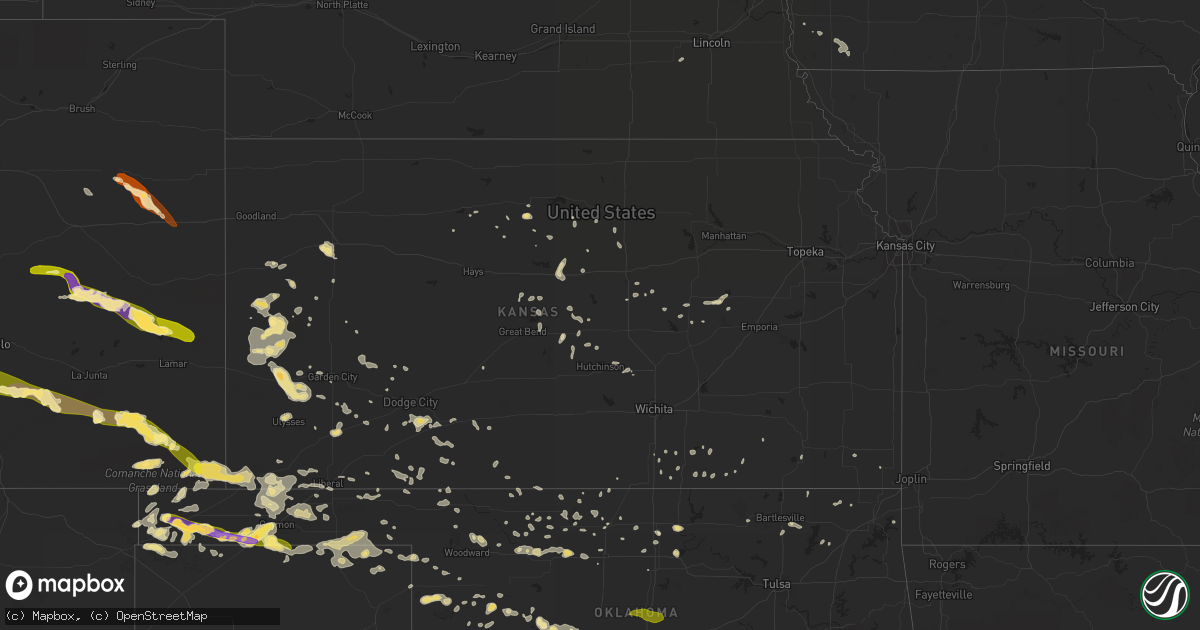
Hail Map in Kansas on June 4, 2013
Get this storm
June 4 map
$229
one time, instant access
Download today. No call, no setup
Keep the $229
Bought the map and want the full workflow? Apply the entire $229 to a subscription within 7 days. None of it is wasted.
Every map, not just this one
This buys you this map. Subscription and you get every map we run, in the markets you choose from a few cities to whole states to nationwide. Plus real-time alerts the moment a storm fires.
Contact data
Name, contact info, occupancy, even credit band for addresses in the footprint. You go from where it hit to who to call.
Become the source they trust
Unlimited branding weather history reports on demand. You already have the documented answer ready for the property owner, and you are the one who showed up with it.
Property data and RoofTrace estimates
Pull up any address you have got, its value and the exact code rules for that jurisdiction, straight from One Click Code. Then RoofTrace estimates the squares, pitch, and roof value, priced the way you price.
Storm reports in Kansas
Kansas
| Date | Description |
|---|---|
| 06/04/201312:15 AM CDT | A local report indicates 65 MPH wind near 1 ENE ASHLAND |
| 06/03/201311:00 PM CDT | A few live 1-inch limbs were blown down. Estimated wind speeds of 60 mph. |
| 06/03/201310:30 PM CDT | The dispatcher reported power lines down all over town. Winds were estimated at greater than 50 mph. |
| 06/03/201310:06 PM CDT | Hqg 1006 pm 29053g60kt 7sm +tsra sct007 sct04 bkn032 68/57 a02 rh68 wind |
| 06/03/20139:30 PM CDT | Tree branches broke...trampoline blown over...dime sized hail. |
| 06/03/20139:22 PM CDT | A local report indicates a tornado near 9 SW LAKIN |
| 06/03/20138:50 PM CDT | A local report indicates 1.50 inch wind near 3 SSE SELKIRK |
| 06/03/20138:45 PM CDT | A local report indicates 60 MPH wind near 12 NNW LAKIN |
All States Impacted by Hail Map on June 4, 2013
Cities Impacted by Hail Map on June 4, 2013
- Leoti, KS
- Boise City, OK
- Marathon, TX
- Healdton, OK
- Pritchett, CO
- Karval, CO
- Ordway, CO
- Sugar City, CO
- Keyes, OK
- Texhoma, OK
- Merkel, TX
- Trent, TX
- Lakin, KS
- Syracuse, KS
- Halstead, KS
- Dorchester, NE
- Crete, NE
- Billings, OK
- Satanta, KS
- Sylvan Grove, KS
- Wilson, KS
- Guymon, OK
- Texhoma, TX
- Stratford, TX
- Spearman, TX
- Goodwell, OK
- Gruver, TX
- Oswego, KS
- Wilson, OK
- Ardmore, OK
- Follett, TX
- Booker, TX
- Perryton, TX
- Balko, OK
- Hardesty, OK
- Darrouzett, TX
- Dexter, KS
- Scott City, KS
- Burlington, OK
- Las Animas, CO
- Kim, CO
- Springfield, CO
- Haswell, CO
- Eads, CO
- Fort Stockton, TX
- Tribune, KS
- Osborne, KS
- Hugoton, KS
- Rolla, KS
- Tecumseh, OK
- Norman, OK
- Baldwyn, MS
- Wanette, OK
- Macomb, OK
- Asher, OK
- Lawton, OK
- Minneola, KS
- Ford, KS
- Dodge City, KS
- Burnsville, MS
- Madill, OK
- Marietta, OK
- Ringling, OK
- Nicholls, GA
- Assaria, KS
- Englewood, KS
- Alva, OK
- Davis, OK
- Cherokee, OK
- Carmen, OK
- Dacoma, OK
- Helena, OK
- Hamlin, TX
- Lake Park, MN
- Marienthal, KS
- Lamont, OK
- Hunter, OK
- Wilsey, KS
- Burdick, KS
- Council Grove, KS
- Dalhart, TX
- Arnett, OK
- Leedey, OK
- Oakley, KS
- Campo, CO
- McCaulley, TX
- Abilene, TX
- Ringwood, OK
- Anton, CO
- Cope, CO
- Taloga, OK
- Sylvester, TX
- Pawhuska, OK
- Sterling, KS
- Anadarko, OK
- Verden, OK
- Pond Creek, OK
- Bailey, CO
- Montezuma, KS
- Gate, OK
- Wynnewood, OK
- Pauls Valley, OK
- Bartlesville, OK
- Nowata, OK
- Winfield, KS
- Sedalia, CO
- Watonga, OK
- Wallace, KS
- Howard, KS
- Longton, KS
- El Reno, OK
- Red Rock, OK
- Anson, TX
- Sweetwater, TX
- Overbrook, OK
- Kingston, OK
- Seibert, CO
- Flagler, CO
- Lookeba, OK
- Welch, OK
- Stockton, KS
- Manchester, OK
- Wakita, OK
- Sublette, KS
- Buffalo, OK
- Healy, KS
- Hooker, OK
- Ashland, KS
- Dent, MN
- Richville, MN
- Springer, OK
- Tonkawa, OK
- Greenfield, OK
- Geary, OK
- Wellington, KS
- Felt, OK
- Thackerville, OK
- Waynoka, OK
- Union City, OK
- Yukon, OK
- Ulysses, KS
- Ponca City, OK
- Minco, OK
- Binger, OK
- Glenwood, MN
- Weinert, TX
- Oklahoma City, OK
- Claflin, KS
- Hoisington, KS
- Water Valley, MS
- Shattuck, OK
- Apache, OK
- Cyril, OK
- Fowler, KS
- Paris, MS
- Whitewright, TX
- Liberal, KS
- Chester, OK
- Walters, OK
- Columbus, KS
- Ravenna, TX
- Savoy, TX
- Lincolnville, KS
- Marion, KS
- Crawford, OK
- Beloit, KS
- Essex, IA
- Shenandoah, IA
- Turpin, OK
- Vona, CO
- Gracemont, OK
- Elgin, OK
- Fletcher, OK
- Rush, CO
- Kendall, KS
- Ninnekah, OK
- Coin, IA
- Lincoln, KS
- Ramah, CO
- Perry, OK
- Aline, OK
- Fairview, OK
- Cleo Springs, OK
- Chickasha, OK
- Haskell, TX
- Enid, OK
- Mooreland, OK
- Burrton, KS
- Laverne, OK
- Gainesville, TX
- Whitesboro, TX
- Winona, KS
- Monument, KS
- Indiahoma, OK
- Lahoma, OK
- Meno, OK
- Kenton, OK
- Hinton, OK
- Oxford, MS
- Forgan, OK
- Marlow, OK
- Butler, OK
- Custer City, OK
- Bucklin, KS
- Limon, CO
- Genoa, CO
- Little River, KS
- Wilmore, KS
- Ingalls, KS
- Moline, KS
- Cedar Vale, KS
- Copeland, KS
- Jetmore, KS
- Thaxton, MS
- Calumet, OK
- Okarche, OK
- Fort Supply, OK
- Hawley, MN
- Amorita, OK
- Geneseo, KS
- Lyons, KS
- Imogene, IA
- Randolph, IA
- Fowler, CO
- Caldwell, KS
- Lucas, KS
- Dryden, TX
- Gypsum, KS
- Abilene, KS
- Belle Plaine, KS
- Jet, OK
- Udall, KS
- S Coffeyville, OK
- Walsh, CO
- Elkhart, KS
- Buffalo Creek, CO
- Conifer, CO
- Lorraine, KS
- Garden City, KS
- Duncan, OK
- Holcomb, KS
- Walsenburg, CO
- Model, CO
- Old Glory, TX
- Rule, TX
- Natoma, KS
- Wyandotte, OK
- Waukomis, OK
- Medford, OK
- Mill Creek, OK
- Mannsville, OK
- Burneyville, OK
- Herington, KS
- Gage, OK
- Cement, OK
- Perham, MN
- Burden, KS
- Hutchinson, KS
- Buhler, KS
- Leesburg, GA
- Smithville, GA
- Putnam, OK
- Vici, OK
- Camargo, OK
- Townsend, GA
- Darien, GA
- Higgins, TX
- Delphos, KS
- Minneapolis, KS
- Faxon, OK
- Hennepin, OK
- Cambridge, KS
- Ramer, AL
- Inman, KS
- Ellsworth, KS
- Chase, KS
- Ochelata, OK
- Meade, KS
- Haviland, KS
- Greensburg, KS
- Cimarron, KS
- Tyrone, OK
- Kismet, KS
- Independence, KS
- Midkiff, TX
- Foster, OK
- Ellinwood, KS
- Mountain View, OK
- Sharon, OK
- Hardtner, KS
- Kiowa, KS
- Comanche, OK
- Lake City, KS
- Hammon, OK
- Strong City, KS
- Fay, OK
- Oakwood, OK
- Chelsea, OK
- Luray, KS
- Bowman, SC
- Palco, KS
- Garfield, KS
- Geuda Springs, KS
- South Haven, KS
- Deerfield, KS
- Raymond, KS
- Alton, KS
- Nash, OK
- Cameron, SC
- Orangeburg, SC
- Stamford, TX
- Salina, KS
- Glenwood, IA
- Ensign, KS
- Hendrix, OK
- Sadler, TX
- Tampa, KS
- Lost Springs, KS
- Chattanooga, OK
- Loveland, OK
- Cache, OK
- Rush Springs, OK
- Arkansas City, KS
- White Oak, GA
- Millwood, GA
- Throckmorton, TX
- La Junta, CO
- Trinidad, CO
- Hugo, CO
- Sheridan Lake, CO
- Yoder, CO
- Pueblo, CO
- Rye, CO
- Avondale, CO
- Stratton, CO
- Coyle, OK
- Guthrie, OK
- Crescent, OK
- Meridian, OK


