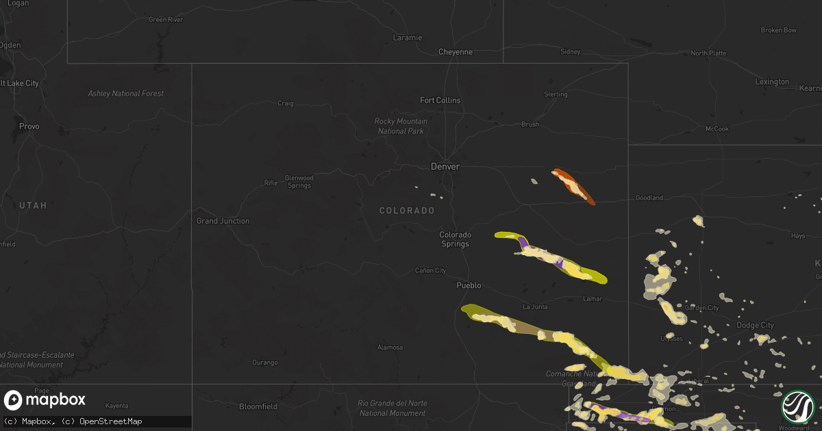
Hail Map in Colorado on June 4, 2013
Get this storm
June 4 map
$229
one time, instant access
Download today. No call, no setup
Keep the $229
Bought the map and want the full workflow? Apply the entire $229 to a subscription within 7 days. None of it is wasted.
Every map, not just this one
This buys you this map. Subscription and you get every map we run, in the markets you choose from a few cities to whole states to nationwide. Plus real-time alerts the moment a storm fires.
Contact data
Name, contact info, occupancy, even credit band for addresses in the footprint. You go from where it hit to who to call.
Become the source they trust
Unlimited branding weather history reports on demand. You already have the documented answer ready for the property owner, and you are the one who showed up with it.
Property data and RoofTrace estimates
Pull up any address you have got, its value and the exact code rules for that jurisdiction, straight from One Click Code. Then RoofTrace estimates the squares, pitch, and roof value, priced the way you price.
Storm reports in Colorado
Colorado
| Date | Description |
|---|---|
| 06/04/20136:53 PM CDT | Funnel cloud with reports from public of contact with the ground were issued through lincoln county sheriff. No damage reported. |
| 06/03/20139:49 PM CDT | A local report indicates 59 MPH wind near 3 NNE GRAND JUNCTION |
| 06/03/20139:20 PM CDT | Gusty winds knocked over 9 sections of wooden privacy fence... Trampoline wrapped around tree |
| 06/03/20139:20 PM CDT | Gusty winds knocked over 9 sections of wooden privacy fence... Trampoline wrapped around tree |
| 06/03/20139:15 PM CDT | A local report indicates 1.00 inch wind near 16 NNE FLAGLER |
| 06/03/20138:59 PM CDT | Ute canyon raws |
| 06/03/20138:35 PM CDT | Trained spotter reported a tornado in the sweetwater resevoir area. |
| 06/03/20138:35 PM CDT | Trained spotter reported a tornado in the sweetwater resevoir area. |
| 06/03/20137:56 PM CDT | Asos recorded 90 mph gust from northwest at 656 pm mdt |
All States Impacted by Hail Map on June 4, 2013
Cities Impacted by Hail Map on June 4, 2013
- Leoti, KS
- Boise City, OK
- Marathon, TX
- Healdton, OK
- Pritchett, CO
- Karval, CO
- Ordway, CO
- Sugar City, CO
- Keyes, OK
- Texhoma, OK
- Merkel, TX
- Trent, TX
- Lakin, KS
- Syracuse, KS
- Halstead, KS
- Dorchester, NE
- Crete, NE
- Billings, OK
- Satanta, KS
- Sylvan Grove, KS
- Wilson, KS
- Guymon, OK
- Texhoma, TX
- Stratford, TX
- Spearman, TX
- Goodwell, OK
- Gruver, TX
- Oswego, KS
- Wilson, OK
- Ardmore, OK
- Follett, TX
- Booker, TX
- Perryton, TX
- Balko, OK
- Hardesty, OK
- Darrouzett, TX
- Dexter, KS
- Scott City, KS
- Burlington, OK
- Las Animas, CO
- Kim, CO
- Springfield, CO
- Haswell, CO
- Eads, CO
- Fort Stockton, TX
- Tribune, KS
- Osborne, KS
- Hugoton, KS
- Rolla, KS
- Tecumseh, OK
- Norman, OK
- Baldwyn, MS
- Wanette, OK
- Macomb, OK
- Asher, OK
- Lawton, OK
- Minneola, KS
- Ford, KS
- Dodge City, KS
- Burnsville, MS
- Madill, OK
- Marietta, OK
- Ringling, OK
- Nicholls, GA
- Assaria, KS
- Englewood, KS
- Alva, OK
- Davis, OK
- Cherokee, OK
- Carmen, OK
- Dacoma, OK
- Helena, OK
- Hamlin, TX
- Lake Park, MN
- Marienthal, KS
- Lamont, OK
- Hunter, OK
- Wilsey, KS
- Burdick, KS
- Council Grove, KS
- Dalhart, TX
- Arnett, OK
- Leedey, OK
- Oakley, KS
- Campo, CO
- McCaulley, TX
- Abilene, TX
- Ringwood, OK
- Anton, CO
- Cope, CO
- Taloga, OK
- Sylvester, TX
- Pawhuska, OK
- Sterling, KS
- Anadarko, OK
- Verden, OK
- Pond Creek, OK
- Bailey, CO
- Montezuma, KS
- Gate, OK
- Wynnewood, OK
- Pauls Valley, OK
- Bartlesville, OK
- Nowata, OK
- Winfield, KS
- Sedalia, CO
- Watonga, OK
- Wallace, KS
- Howard, KS
- Longton, KS
- El Reno, OK
- Red Rock, OK
- Anson, TX
- Sweetwater, TX
- Overbrook, OK
- Kingston, OK
- Seibert, CO
- Flagler, CO
- Lookeba, OK
- Welch, OK
- Stockton, KS
- Manchester, OK
- Wakita, OK
- Sublette, KS
- Buffalo, OK
- Healy, KS
- Hooker, OK
- Ashland, KS
- Dent, MN
- Richville, MN
- Springer, OK
- Tonkawa, OK
- Greenfield, OK
- Geary, OK
- Wellington, KS
- Felt, OK
- Thackerville, OK
- Waynoka, OK
- Union City, OK
- Yukon, OK
- Ulysses, KS
- Ponca City, OK
- Minco, OK
- Binger, OK
- Glenwood, MN
- Weinert, TX
- Oklahoma City, OK
- Claflin, KS
- Hoisington, KS
- Water Valley, MS
- Shattuck, OK
- Apache, OK
- Cyril, OK
- Fowler, KS
- Paris, MS
- Whitewright, TX
- Liberal, KS
- Chester, OK
- Walters, OK
- Columbus, KS
- Ravenna, TX
- Savoy, TX
- Lincolnville, KS
- Marion, KS
- Crawford, OK
- Beloit, KS
- Essex, IA
- Shenandoah, IA
- Turpin, OK
- Vona, CO
- Gracemont, OK
- Elgin, OK
- Fletcher, OK
- Rush, CO
- Kendall, KS
- Ninnekah, OK
- Coin, IA
- Lincoln, KS
- Ramah, CO
- Perry, OK
- Aline, OK
- Fairview, OK
- Cleo Springs, OK
- Chickasha, OK
- Haskell, TX
- Enid, OK
- Mooreland, OK
- Burrton, KS
- Laverne, OK
- Gainesville, TX
- Whitesboro, TX
- Winona, KS
- Monument, KS
- Indiahoma, OK
- Lahoma, OK
- Meno, OK
- Kenton, OK
- Hinton, OK
- Oxford, MS
- Forgan, OK
- Marlow, OK
- Butler, OK
- Custer City, OK
- Bucklin, KS
- Limon, CO
- Genoa, CO
- Little River, KS
- Wilmore, KS
- Ingalls, KS
- Moline, KS
- Cedar Vale, KS
- Copeland, KS
- Jetmore, KS
- Thaxton, MS
- Calumet, OK
- Okarche, OK
- Fort Supply, OK
- Hawley, MN
- Amorita, OK
- Geneseo, KS
- Lyons, KS
- Imogene, IA
- Randolph, IA
- Fowler, CO
- Caldwell, KS
- Lucas, KS
- Dryden, TX
- Gypsum, KS
- Abilene, KS
- Belle Plaine, KS
- Jet, OK
- Udall, KS
- S Coffeyville, OK
- Walsh, CO
- Elkhart, KS
- Buffalo Creek, CO
- Conifer, CO
- Lorraine, KS
- Garden City, KS
- Duncan, OK
- Holcomb, KS
- Walsenburg, CO
- Model, CO
- Old Glory, TX
- Rule, TX
- Natoma, KS
- Wyandotte, OK
- Waukomis, OK
- Medford, OK
- Mill Creek, OK
- Mannsville, OK
- Burneyville, OK
- Herington, KS
- Gage, OK
- Cement, OK
- Perham, MN
- Burden, KS
- Hutchinson, KS
- Buhler, KS
- Leesburg, GA
- Smithville, GA
- Putnam, OK
- Vici, OK
- Camargo, OK
- Townsend, GA
- Darien, GA
- Higgins, TX
- Delphos, KS
- Minneapolis, KS
- Faxon, OK
- Hennepin, OK
- Cambridge, KS
- Ramer, AL
- Inman, KS
- Ellsworth, KS
- Chase, KS
- Ochelata, OK
- Meade, KS
- Haviland, KS
- Greensburg, KS
- Cimarron, KS
- Tyrone, OK
- Kismet, KS
- Independence, KS
- Midkiff, TX
- Foster, OK
- Ellinwood, KS
- Mountain View, OK
- Sharon, OK
- Hardtner, KS
- Kiowa, KS
- Comanche, OK
- Lake City, KS
- Hammon, OK
- Strong City, KS
- Fay, OK
- Oakwood, OK
- Chelsea, OK
- Luray, KS
- Bowman, SC
- Palco, KS
- Garfield, KS
- Geuda Springs, KS
- South Haven, KS
- Deerfield, KS
- Raymond, KS
- Alton, KS
- Nash, OK
- Cameron, SC
- Orangeburg, SC
- Stamford, TX
- Salina, KS
- Glenwood, IA
- Ensign, KS
- Hendrix, OK
- Sadler, TX
- Tampa, KS
- Lost Springs, KS
- Chattanooga, OK
- Loveland, OK
- Cache, OK
- Rush Springs, OK
- Arkansas City, KS
- White Oak, GA
- Millwood, GA
- Throckmorton, TX
- La Junta, CO
- Trinidad, CO
- Hugo, CO
- Sheridan Lake, CO
- Yoder, CO
- Pueblo, CO
- Rye, CO
- Avondale, CO
- Stratton, CO
- Coyle, OK
- Guthrie, OK
- Crescent, OK
- Meridian, OK


