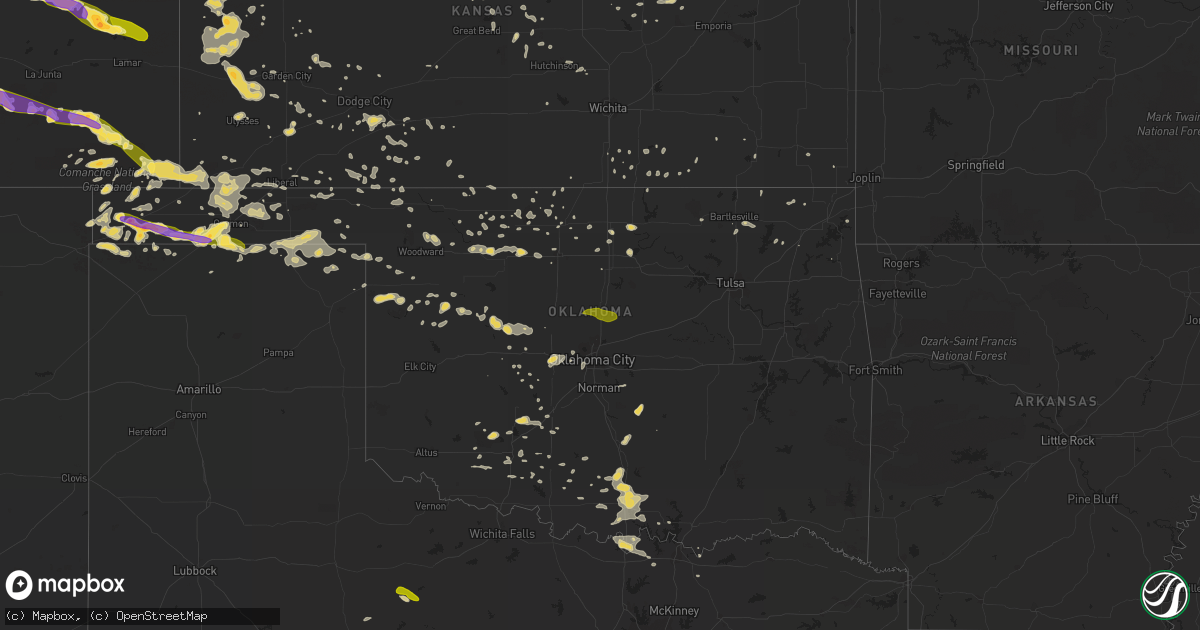
Hail Map on June 4, 2013
Get this storm
June 4 map
$229
one time, instant access
Download today. No call, no setup
Keep the $229
Bought the map and want the full workflow? Apply the entire $229 to a subscription within 7 days. None of it is wasted.
Every map, not just this one
This buys you this map. Subscription and you get every map we run, in the markets you choose from a few cities to whole states to nationwide. Plus real-time alerts the moment a storm fires.
Contact data
Name, contact info, occupancy, even credit band for addresses in the footprint. You go from where it hit to who to call.
Become the source they trust
Unlimited branding weather history reports on demand. You already have the documented answer ready for the property owner, and you are the one who showed up with it.
Property data and RoofTrace estimates
Pull up any address you have got, its value and the exact code rules for that jurisdiction, straight from One Click Code. Then RoofTrace estimates the squares, pitch, and roof value, priced the way you price.
States Impacted by Hail Map on June 4, 2013
Storm reports
California
| Date | Description |
|---|---|
| 06/03/20138:25 PM CDT | The bishop police department reported thunderstorm outflow knocked a large tree down which blocked the roadway near the intersection of west pine street and hammond str |
| 06/03/20138:05 PM CDT | Bishop airport measured a gust to 59 mph from the north from thunderstorm outflow. |
Colorado
| Date | Description |
|---|---|
| 06/04/20136:53 PM CDT | Funnel cloud with reports from public of contact with the ground were issued through lincoln county sheriff. No damage reported. |
| 06/03/20139:49 PM CDT | A local report indicates 59 MPH wind near 3 NNE GRAND JUNCTION |
| 06/03/20139:20 PM CDT | Gusty winds knocked over 9 sections of wooden privacy fence... Trampoline wrapped around tree |
| 06/03/20139:20 PM CDT | Gusty winds knocked over 9 sections of wooden privacy fence... Trampoline wrapped around tree |
| 06/03/20139:15 PM CDT | A local report indicates 1.00 inch wind near 16 NNE FLAGLER |
| 06/03/20138:59 PM CDT | Ute canyon raws |
| 06/03/20138:35 PM CDT | Trained spotter reported a tornado in the sweetwater resevoir area. |
| 06/03/20138:35 PM CDT | Trained spotter reported a tornado in the sweetwater resevoir area. |
| 06/03/20137:56 PM CDT | Asos recorded 90 mph gust from northwest at 656 pm mdt |
Oklahoma
| Date | Description |
|---|---|
| 06/04/20134:00 AM CDT | A local report indicates 64 MPH wind near 2 SSW MINCO |
| 06/04/20133:55 AM CDT | A local report indicates 59 MPH wind near 2 SSW MINCO |
| 06/04/20133:00 AM CDT | A local report indicates 82 MPH wind near 3 SE BRECKENRIDGE |
| 06/04/20132:55 AM CDT | A local report indicates 1.25 inch wind near 15 SW BOISE CITY |
| 06/04/20132:40 AM CDT | A local report indicates 63 MPH wind near 7 W WATONGA |
| 06/04/20131:55 AM CDT | A local report indicates 62 MPH wind near 7 WNW SEILING |
| 06/03/201311:04 PM CDT | A local report indicates 60 MPH wind near 7 N FLORIS |
| 06/03/201310:41 PM CDT | 60 mph winds as well |
| 06/03/201310:40 PM CDT | A local report indicates 1.25 inch wind near 12 S GUYMON |
| 06/03/201310:15 PM CDT | A local report indicates 1.00 inch wind near GOODWELL |
| 06/03/201310:11 PM CDT | A local report indicates 1.00 inch wind near 1 NE TEXHOMA |
| 06/03/201310:05 PM CDT | A local report indicates 1.50 inch wind near TEXHOMA |
| 06/03/201310:05 PM CDT | Estimated wind gust up to 65 miles per hour at his location |
| 06/03/20139:30 PM CDT | Estimated thunderstorm wind gust as high as 60 mph with marble size hail. |
| 06/03/20139:25 PM CDT | A local report indicates 1.00 inch wind near 2 W GRIGGS |
| 06/03/20138:45 PM CDT | A local report indicates 1.50 inch wind near 10 SE BOISE CITY |
| 06/03/20138:44 PM CDT | A local report indicates 1.75 inch wind near 5 SE BOISE CITY |
| 06/03/20138:35 PM CDT | Relayed to our office via nssl. |
| 06/03/20138:27 PM CDT | Few ping pong ball sized but mainly smaller than that |
| 06/03/20138:25 PM CDT | A local report indicates 1.00 inch wind near 1 W BOISE CITY |
Georgia
| Date | Description |
|---|---|
| 06/04/20136:15 PM CDT | Broadcast media relayed a public report of a large pecan tree that was downed in dixie union. Time was estimated based on radar imagery. |
| 06/04/20133:50 PM CDT | Liberty 911 center reported a large tree limb down on a power line blocking wilson ave near n main st. |
| 06/04/20132:40 PM CDT | Long mcintosh 911 reported trees down on murray townsend rd at hwy 99. |
| 06/04/20132:30 PM CDT | Jenkins emergency dispatch reported a tree down on highway 23 s in butts. |
| 06/04/20132:19 PM CDT | Mcintosh county reported several trees down near cypress street in darien. |
| 06/04/20131:44 PM CDT | Media in savannah reported the left lane of interstate 16 west at interstate 516 was blocked due to a fallen tree. Time estimated by radar. |
| 06/04/20131:41 PM CDT | Chatham emergency management reported trees down at chatham center dr. |
| 06/04/20131:41 PM CDT | Chatham emergency management reported trees down at liberty pkwy and acl blvd. |
| 06/04/20131:40 PM CDT | Spotter reported estimated wind gust to 60 mph. |
| 06/04/20131:20 PM CDT | Long mcintosh 911 reported trees down on harris neck rd at eagle neck airport. |
| 06/04/201312:38 PM CDT | Liberty county reported a tree down on camp viking road. Time estimated by radar. |
Texas
| Date | Description |
|---|---|
| 06/04/20132:27 AM CDT | A local report indicates 1.00 inch wind near BOOKER |
| 06/03/201311:03 PM CDT | A local report indicates 1.00 inch wind near MERKEL |
| 06/03/201310:52 PM CDT | A local report indicates 1.00 inch wind near MERKEL |
| 06/03/201310:30 PM CDT | Hail occurred on noodle dome road near the jones and taylor county line. |
| 06/03/20139:45 PM CDT | A local report indicates 1.00 inch wind near 1 W NOODLE |
| 06/03/20139:35 PM CDT | A local report indicates 2.00 inch wind near 3 W NOODLE |
| 06/03/20138:38 PM CDT | Hail slightly larger than golf balls busted the windshield on a vehicle traveling on highway 180 just west of farm to market 126 |
| 06/03/20138:25 PM CDT | Mccaulley resident reported her carport was flipped onto the house. |
| 06/03/20138:10 PM CDT | A local report indicates 2.25 inch wind near 1 S HAMLIN |
| 06/03/20138:03 PM CDT | A local report indicates 1.75 inch wind near 1 SW HAMLIN |
| 06/03/20137:47 PM CDT | Nssl shave report. Hail began at 747 pm and ended at 806 pm |
| 06/03/20137:30 PM CDT | Quarter size hail reprted 2 miles east of the intersection of fm 266 and highway 222 |
| 06/03/20137:30 PM CDT | A local report indicates 4.50 inch wind near 1 SSE HAMLIN |
| 06/03/20137:25 PM CDT | A local report indicates 2.75 inch wind near 1 S HAMLIN |
North Dakota
| Date | Description |
|---|---|
| 06/03/20137:16 PM CDT | Short lived tornado with video and photographic evidence with no damage reported. Initial report received via facebook. |
South Carolina
| Date | Description |
|---|---|
| 06/04/20133:55 PM CDT | Allendale county comms reports a tree down on river road near bluff road. |
| 06/04/20133:50 PM CDT | Allendale county comms reports a tree down on terry road near fairfax-barton highway. |
| 06/04/20133:50 PM CDT | Allendale county comms reports a tree down on terry road near barton road. |
| 06/04/20133:45 PM CDT | Allendale county comms reports a tree down and blocking harmony church road. |
| 06/04/20133:28 PM CDT | Tree reported down on cypress campground road and highway 176. Time estimated by radar. |
| 06/04/20132:47 PM CDT | Dorchester county relayed a report of quarter size hail. Time estimated by radar. |
| 06/04/20132:45 PM CDT | Several trees down near highway 15 near i-26. Time estimated by radar. |
| 06/04/20132:42 PM CDT | Dorchester county reported several trees down along duncan chapel road near highway 15. Time estimated by radar. |
| 06/04/20132:42 PM CDT | A shed was blown into a field...vinyl was blown off of a house and several trees had tops blown off along duncan chapel road near highway 15. Time estimated by radar. |
| 06/04/20132:42 PM CDT | South carolina highway patrol reported a tree down along interstate 26 east boundat exit 172. Time estimated by radar. |
| 06/04/20132:41 PM CDT | Nws survey team found ef-1 damage across northern dorchester county. The tornado touched down just north of the duncan chapel cemetary. The tornado moved south-southeas |
| 06/04/20132:40 PM CDT | Nws columbia damage survey team reported trees down along duncan chapel road just inside the dorchester county line. This damage was possibly caused by the ef-1 tornado |
| 06/04/20132:39 PM CDT | Nws storm survey team found ef-1 damage across northern dorchester county. The tornado entered dorchester county from orangeburg county near duncan chapel. The tornado |
| 06/04/20132:29 PM CDT | Nws storm survey found an ef1 tornado that began near ayshire road and ebenezer road. The tornado continued to move southeast along ebenezer road and then turned right |
| 06/04/20132:28 PM CDT | Hightway patrol reported a tree down on eastbound i-26 near i-95 interchange blocking traffic. |
| 06/04/20132:23 PM CDT | Public report of half dollar size hail on ditch bank road and ebenezer road. |
| 06/04/20132:17 PM CDT | Emergency manager reported trees down on i-26 at the bowman exit. |
Kansas
| Date | Description |
|---|---|
| 06/04/201312:15 AM CDT | A local report indicates 65 MPH wind near 1 ENE ASHLAND |
| 06/03/201311:00 PM CDT | A few live 1-inch limbs were blown down. Estimated wind speeds of 60 mph. |
| 06/03/201310:30 PM CDT | The dispatcher reported power lines down all over town. Winds were estimated at greater than 50 mph. |
| 06/03/201310:06 PM CDT | Hqg 1006 pm 29053g60kt 7sm +tsra sct007 sct04 bkn032 68/57 a02 rh68 wind |
| 06/03/20139:30 PM CDT | Tree branches broke...trampoline blown over...dime sized hail. |
| 06/03/20139:22 PM CDT | A local report indicates a tornado near 9 SW LAKIN |
| 06/03/20138:50 PM CDT | A local report indicates 1.50 inch wind near 3 SSE SELKIRK |
| 06/03/20138:45 PM CDT | A local report indicates 60 MPH wind near 12 NNW LAKIN |
Cities Impacted by Hail Map on June 4, 2013
- Leoti, KS
- Boise City, OK
- Marathon, TX
- Healdton, OK
- Pritchett, CO
- Karval, CO
- Ordway, CO
- Sugar City, CO
- Keyes, OK
- Texhoma, OK
- Merkel, TX
- Trent, TX
- Lakin, KS
- Syracuse, KS
- Halstead, KS
- Dorchester, NE
- Crete, NE
- Billings, OK
- Satanta, KS
- Sylvan Grove, KS
- Wilson, KS
- Guymon, OK
- Texhoma, TX
- Stratford, TX
- Spearman, TX
- Goodwell, OK
- Gruver, TX
- Oswego, KS
- Wilson, OK
- Ardmore, OK
- Follett, TX
- Booker, TX
- Perryton, TX
- Balko, OK
- Hardesty, OK
- Darrouzett, TX
- Dexter, KS
- Scott City, KS
- Burlington, OK
- Las Animas, CO
- Kim, CO
- Springfield, CO
- Haswell, CO
- Eads, CO
- Fort Stockton, TX
- Tribune, KS
- Osborne, KS
- Hugoton, KS
- Rolla, KS
- Tecumseh, OK
- Norman, OK
- Baldwyn, MS
- Wanette, OK
- Macomb, OK
- Asher, OK
- Lawton, OK
- Minneola, KS
- Ford, KS
- Dodge City, KS
- Burnsville, MS
- Madill, OK
- Marietta, OK
- Ringling, OK
- Nicholls, GA
- Assaria, KS
- Englewood, KS
- Alva, OK
- Davis, OK
- Cherokee, OK
- Carmen, OK
- Dacoma, OK
- Helena, OK
- Hamlin, TX
- Lake Park, MN
- Marienthal, KS
- Lamont, OK
- Hunter, OK
- Wilsey, KS
- Burdick, KS
- Council Grove, KS
- Dalhart, TX
- Arnett, OK
- Leedey, OK
- Oakley, KS
- Campo, CO
- McCaulley, TX
- Abilene, TX
- Ringwood, OK
- Anton, CO
- Cope, CO
- Taloga, OK
- Sylvester, TX
- Pawhuska, OK
- Sterling, KS
- Anadarko, OK
- Verden, OK
- Pond Creek, OK
- Bailey, CO
- Montezuma, KS
- Gate, OK
- Wynnewood, OK
- Pauls Valley, OK
- Bartlesville, OK
- Nowata, OK
- Winfield, KS
- Sedalia, CO
- Watonga, OK
- Wallace, KS
- Howard, KS
- Longton, KS
- El Reno, OK
- Red Rock, OK
- Anson, TX
- Sweetwater, TX
- Overbrook, OK
- Kingston, OK
- Seibert, CO
- Flagler, CO
- Lookeba, OK
- Welch, OK
- Stockton, KS
- Manchester, OK
- Wakita, OK
- Sublette, KS
- Buffalo, OK
- Healy, KS
- Hooker, OK
- Ashland, KS
- Dent, MN
- Richville, MN
- Springer, OK
- Tonkawa, OK
- Greenfield, OK
- Geary, OK
- Wellington, KS
- Felt, OK
- Thackerville, OK
- Waynoka, OK
- Union City, OK
- Yukon, OK
- Ulysses, KS
- Ponca City, OK
- Minco, OK
- Binger, OK
- Glenwood, MN
- Weinert, TX
- Oklahoma City, OK
- Claflin, KS
- Hoisington, KS
- Water Valley, MS
- Shattuck, OK
- Apache, OK
- Cyril, OK
- Fowler, KS
- Paris, MS
- Whitewright, TX
- Liberal, KS
- Chester, OK
- Walters, OK
- Columbus, KS
- Ravenna, TX
- Savoy, TX
- Lincolnville, KS
- Marion, KS
- Crawford, OK
- Beloit, KS
- Essex, IA
- Shenandoah, IA
- Turpin, OK
- Vona, CO
- Gracemont, OK
- Elgin, OK
- Fletcher, OK
- Rush, CO
- Kendall, KS
- Ninnekah, OK
- Coin, IA
- Lincoln, KS
- Ramah, CO
- Perry, OK
- Aline, OK
- Fairview, OK
- Cleo Springs, OK
- Chickasha, OK
- Haskell, TX
- Enid, OK
- Mooreland, OK
- Burrton, KS
- Laverne, OK
- Gainesville, TX
- Whitesboro, TX
- Winona, KS
- Monument, KS
- Indiahoma, OK
- Lahoma, OK
- Meno, OK
- Kenton, OK
- Hinton, OK
- Oxford, MS
- Forgan, OK
- Marlow, OK
- Butler, OK
- Custer City, OK
- Bucklin, KS
- Limon, CO
- Genoa, CO
- Little River, KS
- Wilmore, KS
- Ingalls, KS
- Moline, KS
- Cedar Vale, KS
- Copeland, KS
- Jetmore, KS
- Thaxton, MS
- Calumet, OK
- Okarche, OK
- Fort Supply, OK
- Hawley, MN
- Amorita, OK
- Geneseo, KS
- Lyons, KS
- Imogene, IA
- Randolph, IA
- Fowler, CO
- Caldwell, KS
- Lucas, KS
- Dryden, TX
- Gypsum, KS
- Abilene, KS
- Belle Plaine, KS
- Jet, OK
- Udall, KS
- S Coffeyville, OK
- Walsh, CO
- Elkhart, KS
- Buffalo Creek, CO
- Conifer, CO
- Lorraine, KS
- Garden City, KS
- Duncan, OK
- Holcomb, KS
- Walsenburg, CO
- Model, CO
- Old Glory, TX
- Rule, TX
- Natoma, KS
- Wyandotte, OK
- Waukomis, OK
- Medford, OK
- Mill Creek, OK
- Mannsville, OK
- Burneyville, OK
- Herington, KS
- Gage, OK
- Cement, OK
- Perham, MN
- Burden, KS
- Hutchinson, KS
- Buhler, KS
- Leesburg, GA
- Smithville, GA
- Putnam, OK
- Vici, OK
- Camargo, OK
- Townsend, GA
- Darien, GA
- Higgins, TX
- Delphos, KS
- Minneapolis, KS
- Faxon, OK
- Hennepin, OK
- Cambridge, KS
- Ramer, AL
- Inman, KS
- Ellsworth, KS
- Chase, KS
- Ochelata, OK
- Meade, KS
- Haviland, KS
- Greensburg, KS
- Cimarron, KS
- Tyrone, OK
- Kismet, KS
- Independence, KS
- Midkiff, TX
- Foster, OK
- Ellinwood, KS
- Mountain View, OK
- Sharon, OK
- Hardtner, KS
- Kiowa, KS
- Comanche, OK
- Lake City, KS
- Hammon, OK
- Strong City, KS
- Fay, OK
- Oakwood, OK
- Chelsea, OK
- Luray, KS
- Bowman, SC
- Palco, KS
- Garfield, KS
- Geuda Springs, KS
- South Haven, KS
- Deerfield, KS
- Raymond, KS
- Alton, KS
- Nash, OK
- Cameron, SC
- Orangeburg, SC
- Stamford, TX
- Salina, KS
- Glenwood, IA
- Ensign, KS
- Hendrix, OK
- Sadler, TX
- Tampa, KS
- Lost Springs, KS
- Chattanooga, OK
- Loveland, OK
- Cache, OK
- Rush Springs, OK
- Arkansas City, KS
- White Oak, GA
- Millwood, GA
- Throckmorton, TX
- La Junta, CO
- Trinidad, CO
- Hugo, CO
- Sheridan Lake, CO
- Yoder, CO
- Pueblo, CO
- Rye, CO
- Avondale, CO
- Stratton, CO
- Coyle, OK
- Guthrie, OK
- Crescent, OK
- Meridian, OK